| ||||||||||||||
| Banaskantha district | |
|---|---|
| — district — | |
 |
|
| Country | |
| State | Gujarat |
| Headquarters | Palanpur |
| Government | |
| • District Collectorate | R. J. Patel |
| Area | |
| • Total | 10,400.16 km2 (4,015.52 sq mi) |
| Population (2001) | |
| • Total | 2,504,244 |
| • Density | 233/km2 (600/sq mi) |
| Languages | |
| • Official | Gujarati, Hindi |
| Time zone | IST (UTC+5:30) |
| Website | banaskantha.gujarat.gov.in |
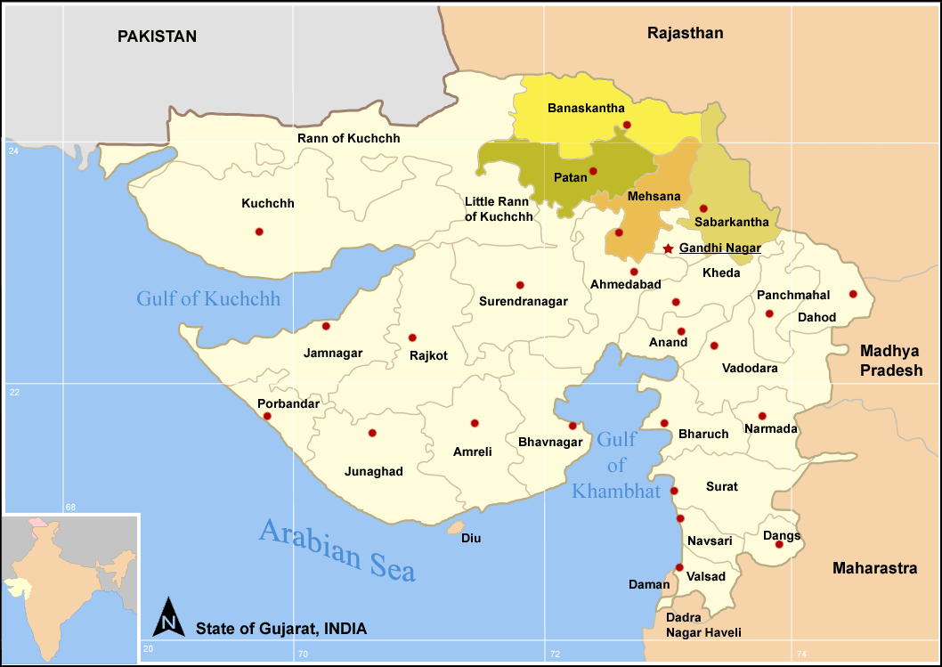
Banaskantha is one among the twenty-six districts of the Gujarat state of India. The administrative headquarters of the district is at Palanpur which is also its largest city. The district is located in the Northeast of Gujarat and is presumably named after the West Banas River which runs through the valley between Mount Abu and Aravalli Range, entering into the plains of Gujarat in this region and flowing towards the Rann of Kutch. The district is famous for the Ambaji temple and the Balaram temple which draw many tourists.
Geography[]
Banaskantha has a population of 2,504,244 of which 11.00% were urban as of 2001. It covers an area of 10,751 km2and is the third largest district in the state. Banaskantha shares its borders with Rajasthan state in the North, Sabarkantha district in East, Kutch district in West and Patan district and Mehsana district in the South.
Economy[]
The economy of the district is based on agro & food Processing, tourism, textile and mineral based industries (ceramics). The food Processing industry in the district has attracted 57% of the total investment in the district over the last two decades The district ranks first in the state in the production of vegetables contributing nearly 17.67% to the total vegetable production of Gujarat. It is the largest producer of potatoes in the state. Bajri, Maize, Tobacco, Castor oil, Jowar, Psyllium are the other major crops of the district. It is also one of the leading producers of Isabgul (Psyllium husk) in the country. It is also the 3rd largest producer of oil seeds in the state after Junagadh district and Jamnagar district.
The district has rich mineral reserves including limestone, marble, granite, building stone and china clay. It accounts for almost the entire marble reserves (99.3%) of Gujarat and contributes about 15% to the total production of limestone in the state.
Banaskantha District Central Co-operative Bank is one of the most important banks of Gujarat.
It has got prestigious State Agricultural University, Sardarkrushinagar Dantiwada Agricultural University, Sardarkrushinagar.[1] The main agriculture is of Bajra crops.
In 2006 the Ministry of Panchayati Raj named Banaskantha one of the country's 250 most backward districts (out of a total of 640).[2] It is one of the six districts in Gujarat currently receiving funds from the Backward Regions Grant Fund Programme (BRGF).[2]
Divisions[]
Administrative divisions[]
In 2000 parts of the district were split for the formation of Patan district.
Taluks[]
The district is divided into twelve talukasnamely,
|
|
Towns[]
Palanpur is the district headquarters and also the largest city. The other major towns in the district are:
- Deesa
- Tharad
- Dhanera
- Ambaji
- Danta
Political divisions[]
Banaskantha constituency is the Lok Sabha constituency for the district.
The seven Vidhan Sabha segments are,
- Vav
- Tharad
- Dhanera
- Danta
- Palanpur
- Deesa
- Deodar
Transport[]
Palanpur and Deesa, the two major cities of the district are well connected to other cities and towns of Gujarat.
Road[]
National Highway 15 connects the district with Pathankot, Amritsar, Bhatinda, Ganganagar, Bikaner and Jaisalmer and Kandla. National Highway 14 connecting Beawar in Rajasthan with Radhanpur in Gujarat passes through Palanpur and Deesa.
Gujarat State Highway 7 connects the district to important cities of Ahmedabad, Patan and State Highway 9 connects Palanpur with Ambaji, the most famous tourist destination in the state. Other state highways passing through the district are 41, 54, 56, 63, 72, 127, 128, 129, 130 and 132 linking it most parts of the state.
Rail[]
Palanpur Junction is the largest railway station of the district. It is connected to Mumbai-Ahmedabad-Jaipur-Delhi corridor thus linking it with four major cities of India. It is also connected to other towns of the district such as Deesa, Deodar, Dhanera and Bhabhar.
Air[]
The district has an airstrip at Palanpur. Sardar Vallabhbhai Patel International Airport in Ahmedabad is the nearest International airport.
Demographics[]
According to the 2011 census Banaskantha district has a population of 3,116,045 ,[3] roughly equal to the nation of Mongolia[4] or the US state of Iowa.[5] This gives it a ranking of 111th in India (out of a total of 640).[3] The district has a population density of 290 inhabitants per square kilometre (750 /sq mi) .[3] Its population growth rate over the decade 2001-2011 was 24.43 %.[3] Banaskantha has a sex ratio of 936 females for every 1000 males,[3] and a literacy rate of 66.39 %.[3]
Culture[]
Notable personalities[]
- Chandrakant Bakshi (1932 - 2006) Author. Born in Palanpur.
References[]
- ^ Sardarkrushinagar Dantiwada Agricultural University
- ^ a b Ministry of Panchayati Raj (September 8, 2009). "A Note on the Backward Regions Grant Fund Programme". National Institute of Rural Development. http://www.nird.org.in/brgf/doc/brgf_BackgroundNote.pdf. Retrieved September 27, 2011.
- ^ a b c d e f "District Census 2011". Census2011.co.in. 2011. http://www.census2011.co.in/district.php. Retrieved 2011-09-30.
- ^ US Directorate of Intelligence. "Country Comparison:Population". https://www.cia.gov/library/publications/the-world-factbook/rankorder/2119rank.html. Retrieved 2011-10-01. "Mongolia 3,133,318 July 2011 est."
- ^ "2010 Resident Population Data". U. S. Census Bureau. http://2010.census.gov/2010census/data/apportionment-pop-text.php. Retrieved 2011-09-30. "Iowa 3,046,355"
External links[]
- Banaskantha District profile
- Detailed Profile
- DISTRICT PROFILE - Rural.nic.in
- Banskantha District Panchayat - English

|
Jalor district, Rajasthan | Sirohi district, Rajasthan |
| |
| Kutch district | Sabar Kantha district | |||
 Banaskantha district | ||||
| Patan district | Mahesana district |
| ||||||||||||||||||||||||||||||
| This page uses content from the English language Wikipedia. The original content was at Banaskantha district. The list of authors can be seen in the page history. As with this Familypedia wiki, the content of Wikipedia is available under the Creative Commons License. |