| Main | Births etc |
|---|
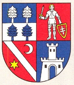
| Banská Bystrica | |||
| Region | |||
| |||
| Official name: Banskobystrický kraj | |||
| Country | Slovakia | ||
|---|---|---|---|
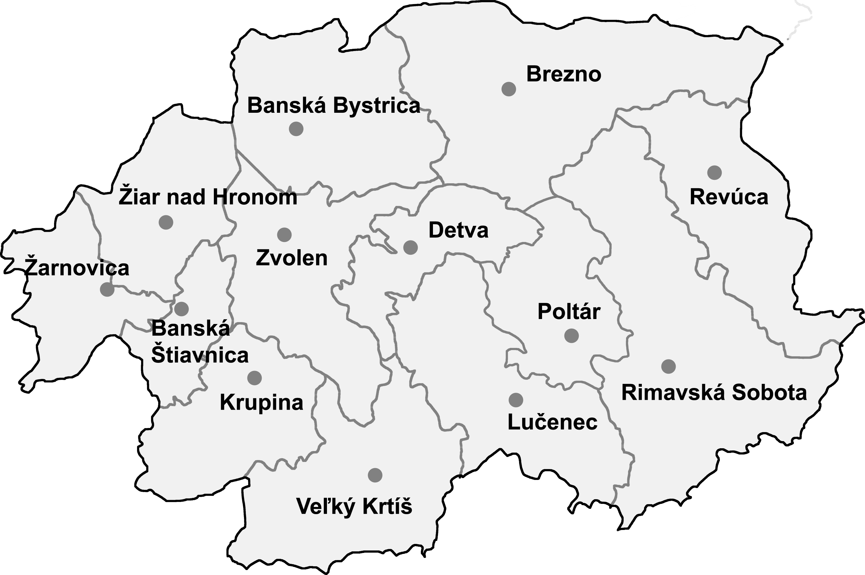
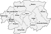
| Districts | 13
| ||
| Seat | Banská Bystrica | ||
| - elevation | 362 m (1,188 ft) | ||
| - coordinates | |||
| Highest point | Ďumbier | ||
| - elevation | 2,046 m (6,713 ft) | ||
| Lowest point | Štiavnica | ||
| - elevation | 135 m (443 ft) | ||
| Area | 9,454.8 km² (3,650.5 sq mi) | ||
| Population | 653,697 (2008-12-31) | ||
| Density | 69 / km² (179 / sq mi) | ||
| Timezone | CET (UTC+1) | ||
| - summer (DST) | CEST (UTC+2) | ||

| |||
| Statistics: MOŠ/MIS | |||
| Website: [http://www.vucbb.sk www.vucbb.sk] | |||

The Banská Bystrica Region (Slovak: Banskobystrický kraj) is one of the Slovak regions in the country of Slovakia in Europe.
Geography[]
It is located in the central part of Slovakia and has an area of 9,455 km². The region is prevailingly mountains, with several ranges within the area. The highest of them are the Low Tatras in the north, where the highest point, Ďumbier, is located. Some of the mountain ranges in the west include Kremnica Mountains, Vtáčnik and Štiavnica Mountains. The Javorie and Krupina Plain ranges are located in the centre. The Slovak Ore Mountains are running from the central areas to the east, along with its subdivisions (e.g. Poľana, Veporské vrchy, Muránska planina and Spiš-Gemer Karst). Lower lying areas are located in the south, represented by the Southern Slovak Basin, running along the borders with Hungary. Major rivers are the Hron in the northern half, Ipeľ in the south and centre, Rimava and for short length Slaná in the east. As for administrative division, the region borders Žilina Region in the north, Prešov Region in the north-east, Košice Region in the east, Hungarian Borsod-Abaúj-Zemplén county in the south-east, Nógrád county in the south and Pest county in the south-west, Nitra Region in the west and Trenčín Region in the north-west.
Demographics[]
The population density in the region is 69.5 inhabitants per km², what is the least of all Slovak regions and much less than country's average (110 per km²). The largest towns are Banská Bystrica, Zvolen, Lučenec and Rimavská Sobota. According to the 2001 census, there were 662,121 inhabitants in the region, with a majority of Slovaks (83.7%), but there is a Hungarian minority (11.8%) along Hungarian border, and there are small minorities of Roma (2.3%) and Czechs(<1%).[1]
Districts of Banská Bystrica Region
List of districts (okresy)[]
- Banská Bystrica District
- Banská Štiavnica District
- Brezno District
- Detva District
- Krupina District
- Lučenec District
- Poltár District
- Revúca District
- Rimavská Sobota District
- Veľký Krtíš District
- Zvolen District
- Žarnovica District
- Žiar nad Hronom District
List of municipalities and towns[]
There are 513 municipalities, of which 24 are towns (in bold), where the 56% of the region's population live.
- Ábelová
- Abovce
- Babinec
- Bacúch
- Baďan
- Balog nad Ipľom
- Banská Belá
- Banská Bystrica
- Banská Štiavnica
- Banský Studenec
- Barca
- Bartošova Lehôtka
- Bátka
- Bátorová
- Belín
- Belina
- Beluj
- Beňuš
- Biskupice
- Blhovce
- Boľkovce
- Bottovo
- Braväcovo
- Brehy
- Breznička
- Brezno
- Brusník
- Budikovany
- Bulhary
- Bušince
- Bystrá, Brezno
- Bzenica
- Bzovík
- Cakov
- Cerovo
- Cinobaňa
- Čabradský Vrbovok
- Čakanovce
- Čamovce
- Čebovce
- Čekovce
- Čeláre
- Čelovce
- Čerenčany
- Červeňany
- České Brezovo
- Čierny Balog
- Čierny Potok
- Číž
- Dačov Lom
- Dekýš
- Detva
- Detvianska Huta
- Devičie
- Divín
- Dobroč
- Dolinka
- Dolná Lehota
- Dolná Strehová
- Dolná Trnávka
- Dolná Ves
- Dolná Ždaňa
- Dolné Mladonice
- Dolné Plachtince
- Dolné Strháre
- Dolné Zahorany
- Dolný Badín
- Domaníky
- Donovaly
- Drábsko
- Dražice
- Drážovce
- Drienčany
- Drienovo
- Drňa
- Držkovce
- Ďubákovo
- Dubno
- Dubovec
- Dúbravy
- Dudince
- Dulovo
- Ďurkovce
- Figa
- Fiľakovo
- Fiľakovské Kováče
- Gemer
- Gemerček
- Gemerská Ves
- Gemerské Dechtáre
- Gemerské Michalovce
- Gemerské Teplice
- Gemerský Jablonec
- Gemerský Sad
- Glabušovce
- Gortva
- Gregorova Vieska
- Hajnáčka
- Halič
- Heľpa
- Hliník nad Hronom
- Hnúšťa
- Hodejov
- Hodejovec
- Hodruša-Hámre
- Holiša
- Hontianske Moravce
- Hontianske Nemce
- Hontianske Tesáre
- Horná Lehota
- Horná Strehová
- Horná Ves
- Horná Ždaňa
- Horné Hámre
- Horné Mladonice
- Horné Plachtince
- Horné Strháre
- Horné Zahorany
- Horný Badín
- Horný Tisovník
- Hostice
- Hostišovce
- Hrabičov
- Hradište
- Hrachovo
- Hriňová
- Hrlica
- Hrnčiarska Ves
- Hrnčiarske Zalužany
- Hronec
- Hronská Dúbrava
- Hrušov
- Hrušovo
- Hubovo
- Hucín
- Husiná
- Chanava
- Chrámec
- Chrastince
- Chrťany
- Chvalová
- Chyžné
- Ihráč
- Ilija
- Ipeľské Predmostie
- Ivanice
- Jalšovík
- Janovice
- Janova Lehota
- Jarabá
- Jasenie
- Jastrabá
- Jelšava
- Jelšovec
- Jesenské
- Jestice
- Kalinovo
- Kalonda
- Kaloša
- Kameňany
- Kamenné Kosihy
- Kesovce
- Kiarov
- Kľak
- Kleňany
- Klenovec
- Klokoč
- Kociha
- Kokava nad Rimavicou
- Koláre
- Konrádovce
- Kopernica
- Korytárky
- Kosihovce
- Kosihy nad Ipľom
- Kosorín
- Kotmanová
- Kováčovce
- Kozelník
- Kozí Vrbovok
- Krahule
- Kráľ
- Kráľovce-Krnišov
- Kremnica
- Kremnické Bane
- Kriváň (village)
- Krná
- Krokava
- Krupina
- Kružno
- Kunešov
- Kyjatice
- Lackov
- Ladomeská Vieska
- Ladzany
- Látky
- Lehota nad Rimavicou
- Lehôtka pod Brehmi
- Lehôtka
- Lenartovce
- Lenka
- Lentvora
- Lesenice
- Lešť
- Leváre
- Levkuška
- Licince
- Lipovany
- Lipovec
- Lišov
- Litava
- Lom nad Rimavicou
- Lovča
- Lovčica-Trubín
- Lovinobaňa
- Lubeník
- Ľuboreč
- Ľuboriečka
- Lučenec
- Lúčky
- Lukovištia
- Lupoč
- Lutila
- Magnezitovce
- Malá Čalomija
- Malá Lehota
- Malé Straciny
- Malé Zlievce
- Málinec
- Malý Krtíš
- Martinová
- Mašková
- Medovarce
- Michalová
- Mládzovo
- Močiar
- Modrý Kameň
- Mokrá Lúka
- Mučín
- Muľa
- Muráň
- Muránska Dlhá Lúka
- Muránska Huta
- Muránska Lehota
- Muránska Zdychava
- Mýtna
- Mýto pod Ďumbierom
- Nandraž
- Nemecká
- Nenince
- Neporadza
- Nevoľné
- Nitra nad Ipľom
- Nižný Skálnik
- Nová Baňa
- Nová Bašta
- Nová Ves
- Obeckov
- Olováry
- Opatovská Nová Ves
- Opava
- Orávka
- Orovnica
- Osrblie
- Ostrý Grúň
- Otročok
- Ozdín
- Ožďany
- Padarovce
- Panické Dravce
- Pavlovce
- Petrovce
- Píla
- Pitelová
- Pleš
- Ploské
- Počúvadlo
- Podbrezová
- Podhorie
- Podkriváň
- Podrečany
- Pohorelá
- Pohronská Polhora
- Polichno
- Polina
- Polomka
- Poltár
- Poproč
- Potok
- Pôtor
- Praha
- Pravica
- Predajná
- Prenčov
- Príbelce
- Prihradzany
- Prochot
- Prša
- Radnovce
- Radzovce
- Rákoš
- Rakytník
- Rapovce
- Rašice
- Ratka
- Ratková
- Ratkovská Lehota
- Ratkovská Suchá
- Ratkovské Bystré
- Ráztoka
- Revúca
- Revúcka Lehota
- Riečka
- Rimavská Baňa
- Rimavská Seč
- Rimavská Sobota
- Rimavské Brezovo
- Rimavské Janovce
- Rimavské Zalužany
- Rovňany
- Rovné
- Rudno nad Hronom
- Rumince
- Ružiná
- Rybník
- Rykynčice
- Sása, Revúca
- Sása, Zvolen
- Sebechleby
- Sečianky
- Seľany
- Selce, Poltár District
- Selce, Krupina District
- Senné
- Senohrad
- Sihla
- Sirk
- Skerešovo
- Sklabiná
- Sklené Teplice
- Slaska
- Slatinské Lazy
- Sliač
- Slizké
- Slovenské Ďarmoty
- Slovenské Kľačany
- Stará Bašta
- Stará Halič
- Stará Huta
- Stará Kremnička
- Stožok
- Stránska
- Stredné Plachtince
- Studená
- Sudince
- Súdovce
- Sucháň
- Suché Brezovo
- Sušany
- Sútor
- Svätý Anton
- Šávoľ
- Šiatorská Bukovinka
- Šíd
- Šimonovce
- Širákov
- Širkovce
- Šivetice
- Šoltýska
- Špania Dolina
- Španie Pole
- Štiavnické Bane
- Štrkovec
- Šuľa
- Šumiac
- Šurice
- Tachty
- Tekovská Breznica
- Telgárt
- Teplý Vrch
- Terany
- Tisovec
- Točnica
- Tomášovce
- Tornaľa
- Trebeľovce
- Trebušovce
- Trenč
- Trnavá Hora
- Trpín
- Tuhár
- Turčok
- Uhorské
- Uňatín
- Utekáč
- Uzovská Panica
- Valaská
- Valice
- Vaľkovňa
- Včelince
- Večelkov
- Veľká Čalomija
- Veľká Lehota
- Veľká Lúka
- Veľká nad Ipľom
- Veľká Ves nad Ipľom
- Veľká Ves
- Veľké Dravce
- Veľké Pole
- Veľké Straciny
- Veľké Teriakovce
- Veľké Zlievce
- Veľký Blh
- Veľký Krtíš
- Veľký Lom
- Vidiná
- Vieska nad Blhom
- Vieska
- Vígľaš
- Vígľašská Huta-Kalinka
- Vinica
- Višnové
- Vlkyňa
- Voznica
- Vrbovka
- Vyhne
- Vysoká
- Vyšné Valice
- Vyšný Skálnik
- Zádor
- Záhorce
- Zacharovce
- Závada
- Závadka nad Hronom
- Zemiansky Vrbovok
- Zlatno
- Zombor
- Zvolen
- Žarnovica
- Železná Breznica
- Želovce
- Žiar nad Hronom
- Žiar
- Žibritov
- Žíp
- Župkov
References[]
- Kopa, Ľudovít et al. (2006). The Encyclopaedia of Slovakia and the Slovaks. Bratislava, Slovakia: Encyclopaedic Institute of the Slovak Academy of Sciences. ISBN 80-224-0925-1.
External links[]
- Banskobystrický samosprávny kraj Official website
| This page uses content from the English language Wikipedia. The original content was at Banská Bystrica Region. The list of authors can be seen in the page history. As with this Familypedia wiki, the content of Wikipedia is available under the Creative Commons License. |