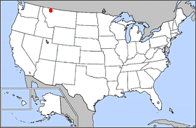
Blackfeet Indian Reservation in the U.S. state of Montana

Entering the reservation on U.S. Route 2
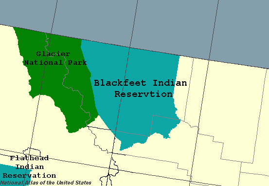
The Blackfeet Nation also known as the Blackfeet Tribe of the Blackfeet Indian Reservation[1] is an Indian reservation and headquarters for the Siksikaitsitapi people in the United States. Located in Montana, its members are composed primarily of the Piegan Blackfeet (Ampskapi Piikani) band of the larger ethnic group historically described as the Blackfoot Confederacy. It is located east of Glacier National Park and borders the Canadian province of Alberta. Cut Bank Creek and Birch Creek form part of its eastern and southern borders. The reservation contains 3,000 square miles (7,800 km2), twice the size of the national park and larger than the state of Delaware. It is located in parts of Glacier and Pondera counties.
The reservation is also east of the Lewis and Clark National Forest in Montana, which contains the Badger-Two Medicine area, sacred to the Blackfeet people.[2] This sacred part of the Rocky Mountain Front was excluded from Blackfeet lands in a Treaty of 1896 but they reserved access, hunting and fishing rights. Since the early 1980s, when the Bureau of Land Management approved drilling rights leases without consultation with the tribe, the Blackfeet have worked to protect this sacred area, where they practiced their traditional religious rituals.
The federal government suspended all leasing activities for drilling in this area in the 1990s, and in 2007 the Bush administration made permanent a moratorium on issuing new permits. Many leaseholders had already relinquished their leases, and in November 2016 the Department of Interior announced the cancellation of the 15 drilling rights leases held by Devon Energy Corporation in the Badger-Two Medicine area.[2] The Blackfeet had documented that the area was not a "wilderness," as the Bob Marshall Wilderness Complex was designated in 1964, but a "human landscape" shaped by and integral to their culture.[2]
Geography[]
Elevations in the reservation range from a low of 3,400 feet (1,000 m) to a high of 9,066 feet (2,763 m) at Chief Mountain. Adjacent mountains include Ninaki Mountain and Papoose. The eastern part of the reservation is mostly open hills of grassland, while a narrow strip along the western edge is covered by forests of fir and spruce. Free-ranging cattle are present in several areas, sometimes including on roadways.
Several waterways drain the area with the largest being the St. Mary River, Two Medicine River, Milk River, Birch Creek and Cut Bank Creek. There are 175 miles (282 km) of streams and eight major lakes on the reservation.
Demographics[]

Blackfeet Indian Reservation, looking at the mountains of Glacier National Park
The 2010 census reported a population of 10,405 living on the reservation lands.[3] The population density is 3.47 people per square mile (1.34 people/km²).
The Blackfeet Nation has 16,500 registered members. The main community is Browning, which is the seat of tribal government. Other towns serve the tourist economy along the edge of the park: St. Mary and East Glacier Park Village, which has an Amtrak passenger station and the historic Glacier Park Lodge. Small communities include Babb, Kiowa, Blackfoot, Seville, Heart Butte, Starr School, and Glacier Homes.
The nation celebrates North American Indian Days, an annual festival held on pow wow grounds, near the Museum of the Plains Indian in Browning. Adjacent to the reservation's eastern edge is the city of Cut Bank.
Communities[]
- Babb
- Browning
- East Glacier Park Village
- Heart Butte
- Little Browning
- North Browning
- St. Mary
- South Browning
- Starr School
History[]
The Blackfeet and their ancestors have occupied this area for 10,000 years, according to their oral history. They dominated a large territory extending into what has been defined as Canada since the 19th century. Their sacred history was centered in what is now known as the Badger-Two Medicine area, known as their "Cathedral" of origin and creation.
In the late 19th century, Blackfeet territory was encroached on by European Americans and Canadians, and various branches of the people were forced to cede lands and ultimately move to smaller Indian reservations in the United States and reserves in Canada.[2] Adjacent to their reservation, established by Treaty of 1896, are two federally controlled areas: the Lewis and Clark National Forest, set up in 1896, which contains the Badger-Two Medicine area, an area of 200 square miles (130,000-acres); and Glacier National Park, both part of the tribal nation's former territory.
The Badger-Two Medicine area is at the Rocky Mountain Front of the national forest. The Blackfeet call the Rocky Mountains the "Backbone of the World." Their names for peaks include Morning Star, Poia, Little Plume, Running Crane, Spotted Eagle, Kiyo, Scarface, Elkcalf Bullshoe, and Curly Bear.[4]
The Rocky Mountain Front near Birch Creek The Badger-Two Medicine is "covered by the Treaty of 1896, which gives Blackfeet tribal members the right to hunt and fish in any portion of the area in accordance with state law and cut wood for domestic use. Blackfeet treaty claims as well as spiritual and cultural uses of the Badger-Two Medicine are pre-existing rights... Blackfeet tribal members have used the Badger-Two Medicine and its waters for hundreds of years for vision quests and for other religious and cultural purposes."[4]
Government[]

Relationship of the National Park and the reservation
The Blackfeet Nation runs the sovereign government on the reservation through its elected Tribal Business Council. For many years Earl Old Person led the organization, and As of 2016 remains a council member.[5] Old Person is also the honorary chief of the tribe.[6] It provides most services, including courts, child welfare, employment assistance, wildlife management, health care, education, land management, and senior services, as well as garbage collection and water systems. They worked with the federal Bureau of Indian Affairs to replace native police with federal officers in 2003 because of problems in the local force.
The reservation includes several types of land use. Of the total 1,462,640 acres (5,919.09 km2), 650,558 acres (2,632.715 km2) are held in trust for enrolled tribal members, 311,324 acres (1,259.884 km2) are held directly by the tribe, and 8,292 acres (33.557 km2) are Government Reserve, mostly irrigation projects and the Cut Bank Boarding School Reserve. The remaining 529,826 acres (2,144.130 km2) are Fee lands, which is taxable and may be privately owned by the tribe, tribe members or non-tribe members.
The tribe leases some of its communal land for homes, farms, grazing, and commercial uses. They offer leases to tribe members prior to any offers to non-members. The tribe has the right of first refusal; all private land offered for sale within the reservation must be offered to the tribe first. If they decline to purchase it, they grant a waiver permitting purchase by non-Native parties.
Culture[]
The tribe has an oral history of 10,000 years in this region. It recounts the sacred nature of their central place, the Badger-Two Medicine area, known as their site of creation and origin.
In 2002, the Department of Interior declared roughly two-thirds (almost 90,000 acres) of the Badger-Two Medicine area along the Rocky Mountain Front as eligible for listing as a Traditional Cultural District in the National Register of Historic Places.[4] This was a recognition of its importance to the Blackfeet. They used an ethnographer to document their oral history of use and practices, and in 2014 used this information to negotiate with stakeholders over leases for drilling rights that had been made in the area.[2]
Economy[]
Because of its isolated location, residents of the reservation have suffered high unemployment. As of May 2016, the Montana Local Area Unemployment Statistics (LAUS) Program Preliminary Non-Seasonally Adjusted Data reports the rate is 11.0% on the reservation (for comparison, at the same time, unemployment was 3.6% for Montana and 4.5% for the U.S.).[7]
In 2001, the BIA reported 69% unemployment among registered members of the tribe.[8] Among those who were employed that year, 26% earned less than the poverty guideline.
The major income source of the reservation is oil and natural gas leases on the oil fields on tribal lands. In 1982, there were 643 producing oil wells and 47 producing gas wells.
The reservation also has a significant tourist industry. Other economic activities include ranching and a small lumber industry, which supported the Blackfeet Indian Writing Company pencil factory in Browning.[9]
There are no paved north-south roads in Glacier National Park. Access to sites on the east side of the park is provided by U.S. Route 89, which runs through the reservation to the Canada–US border, crossing near Chief Mountain. It provides access to the Canadian sister national park, Waterton Lakes. Both east-west routes for the park travel through the reservation, as does the passenger train service on Amtrak's Empire Builder. Several hiking trails continue out of the park and across the reservation; they require Blackfeet-issued permits for use.
Farms located at least partially on the reservation reported a total income of $9 million in 2002. A total of 354 farms covered 1,291,180 acres (5,225.22 km2), the majority of the reservation's land. Most of these farms or ranches were family-owned, including the 198 farms owned by Native Americans.[10]
Eighty percent of the land was used for raising beef cattle, which produced eighty percent of farm income. Other livestock included hogs, and chickens, with only small numbers of dairy cattle, bison, horses, and sheep.[10]
Of the 245,530 acres (993.62 km2) used for growing crops, only 32,158 acres (130.139 km2), or 13%, were irrigated. Crops raised included wheat, barley, and hay with a smaller amount of oats.[10]
Members of the tribe work seasonally in wildfire firefighting, a source of considerable individual income. In 2000, some 1,000 Blackfeet worked as firefighters, including the elite Chief Mountain Hotshots team. Firefighting income brought in $6.1 million that year. However, this income is highly variable depending on the severity of the wildfire season.
In a marathon session on Friday, April 30, 2010, the Blackfeet Tribal Business Council (BTBC) approved three major initiatives totaling $5.5 million. The revenue was to be derived from payments for oil exploration from Newfield Production Co.
The BTBC approved a $200 special per capita payments for all 16,500 members, initial funding for a new grocery store in Browning, and more than $1 million for land acquisition within the reservation to return property to tribal control. They planned to make the $200 per capita payments within 60 days. This special per capita is separate from the annual December per capita payments made from leasing revenues.
Notable people[]
- Gordon Belcourt (1945-2013), Former Executive Director of the Montana-Wyoming Tribal Leaders Council[11]
- Elouise P. Cobell, former tribal treasurer and founder of Blackfeet Nation Bank. She identified mismanagement of trust land fees by the departments of Interior and Treasury, and sought corrections in Washington. In 1996 she filed a class-action suit against the government in what is known as Cobell v. Salazar, settled by the federal government for $3.4 billion in 2009. The settlement provides for payment to potentially more than 250,000 plaintiffs, repurchase of lands across the country for transfer to tribal management, and a scholarship fund for Native American and Alaskan Native students.
- Richie Havens (1941-2013), singer-songwriter and guitarist
- Donna Hutchinson, elected as member of the Arkansas House of Representatives from Bella Vista, Arkansas, served from 2007 to 2013
- Earl Old Person, Tribal Chief and political leader
- Steve Reevis (b. August 14, 1962), actor (Geronimo: An American Legend, The Missing, Fargo (film))
- Misty Upham (1982-2014), actor[12]
- Black Lodge Singers, traditional music and drum group
See also[]
- Tipi ring - information about study of tipi ring sites on the Blackfeet Indian Reservation
Notes[]
- ^ "Blackfeet Nation Constitution". http://blackfeetnation.com/government/constitution/. Retrieved 22 July 2017.
- ^ a b c d e Renae Ditmer, "On Eve of Film Premier, Interior Cancels Oil and Gas Leases in Blackfeet ‘Cathedral’", Indian Country Today, 22 November 2016; accessed 23 November 2016
- ^ "Census shows growth at 4 Montana reservations". helenair.com/Independent Record. 28 March 2011. http://helenair.com/news/article_98cba378-5967-11e0-a41b-001cc4c002e0.html. Retrieved 2 April 2011.
- ^ a b c Rocky Mountain Front, Browning, Montana website
- ^ "Old Person: A legacy for the ages". http://www.greatfallstribune.com/story/life/my-montana/2015/07/16/old-persons-commitment-tribe-spans-two-centuries/30253215/.
- ^ Jack McNeel, "10 Things You Should Know about the Blackfeet Nation", Indian Country Today, 19 November 2015; accessed 24 November 2016
- ^ "lmi.mt.gov > Home". http://lmi.mt.gov/.
- ^ "Bureau of Indian Affairs Calculation of Unemployment Rates for Montana Indian Reservations". February 2007. Archived from the original on May 4, 2005. https://web.archive.org/web/20050504175810/http://dli.state.mt.us/resources/indianlabormarket.asp. Retrieved 2013-04-28.
- ^ "Blackfeet Indian Writing Co., Inc.". http://www.pencilpages.com/mfg/blackfet.htm.
- ^ a b c "NATIONAL AGRICULTURAL STATISTICS SERVICE". October 2004. Archived from the original on July 11, 2007. https://web.archive.org/web/20070711031532/http://www.nass.usda.gov/census/amindian.txt. Retrieved 2013-04-28.
- ^ Devlin, Vince (2013-07-17). "Gordon Belcourt remembered as advocate for Indian Country". The Missoulian. http://missoulian.com/news/local/gordon-belcourt-remembered-as-advocate-for-indian-country/article_2dc0817a-ee8e-11e2-88c1-0019bb2963f4.html. Retrieved 2013-08-10.
- ^ Schmidt, Rob. " Blackfeet Actress Misty Upham On Filming 'Jimmy P.' with Benicio Del Toro", Indian Country Today Media Network, 30 Sept 2013. Accessed 1 Feb 2014.
References[]
- Farr, William E. The Reservation Blackfeet: A Photographic History of Cultural Survival. Foreword by James Welch. Seattle: University of Washington Press, 1984. ISBN 0-295-96040-X
- McFee, Malcolm. Modern Blackfeet: Montanans on a Reservation. New York: Holt, Rinehart and Winston, 1972. ISBN 0-03-085768-6
External links[]
- Blackfeet Tribal Land Department
- Official tribe website
- Blackfeet Reservation and Off-Reservation Trust Land, Montana, United States Census Bureau
- Singer/songwriter/storyteller/lecturer Jack Gladstone
- James Willard Schultz Papers, 1867-1969, University of Montana Library
| ||||||||||||||||||||||||||||||

Template:Indian reservations in Montana Coordinates: