| Main | Births etc |
|---|
| City of Bloomfield Hills | |||
|---|---|---|---|
| — City — | |||
 |
|||
|
|||
 |
|||
| Coordinates: Coordinates: | |||
| Country | United States | ||
| State | Michigan | ||
| County | Oakland | ||
| Government[1] | |||
| • Type | Commission-Manager | ||
| • Mayor | Sarah H. McClure | ||
| • City Manager | Jay Cravens | ||
| Area[2] | |||
| • City | 5.04 sq mi (13.05 km2) | ||
| • Land | 4.96 sq mi (12.85 km2) | ||
| • Water | 0.08 sq mi (0.21 km2) | ||
| Elevation | 833 ft (254 m) | ||
| Population (2010)[3] | |||
| • City | 3,869 | ||
| • Estimate (2012[4]) | 3,931 | ||
| • Density | 780.0/sq mi (301.2/km2) | ||
| • Metro | 4,296,250 | ||
| Time zone | EST (UTC-5) | ||
| • Summer (DST) | EDT (UTC-4) | ||
| ZIP code | 48304 | ||
| Area code(s) | 248 | ||
| FIPS code | 26-09180[5] | ||
| GNIS feature ID | 0621616[6] | ||
| Website | http://www.bloomfieldhillsmi.net | ||
Bloomfield Hills is a city located in Metro Detroit's northern suburbs in Oakland County in the US state of Michigan, 20.2 miles (32.5 km) northwest of downtown Detroit. The city is almost completely surrounded by Bloomfield Township.[7] As of the 2010 census, the city population was 3,869.[8] Bloomfield Hills consistently ranks as one of the top five wealthiest cities in the United States with population between 2,500 to 9,999 – it currently is listed at the number four position and in 1990 it was ranked number two.[9] Bloomfield Hills has the second highest income for a municipality with over 1,000 households in the country and the highest income in the state of Michigan.[10]
History[]
On June 28, 1820, Oakland County was divided into two townships: Pontiac Township and Bloomfield Township, the latter covering the southern part of the county that would include West Bloomfield Township, Royal Oak and Southfield. What is now Bloomfield Hills was a farming area until the turn of the 20th century when wealthy Detroit residents bought up the land. The settlement became a village in 1927, and in 1932 residents voted to become a city to avoid being incorporated into growing Birmingham.
The origin of the name "Bloomfield" is uncertain. Bloomfield Hills' former names were "Bagley's Corners", after early settler Amasa Bagley, and "Circle City."
Culture[]
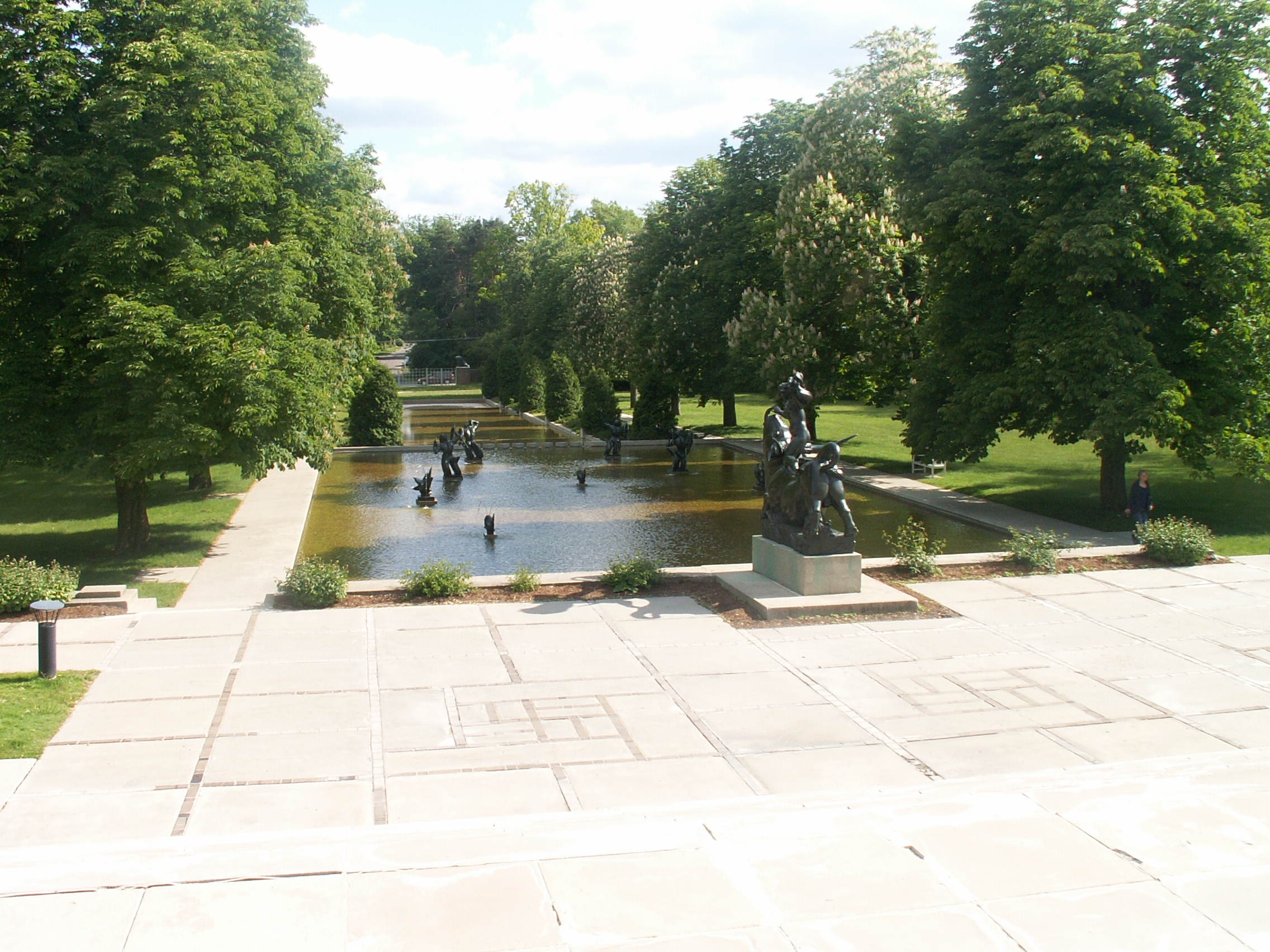
Cranbrook gardens
Bloomfield Hills is the location of the National Historic Landmark Cranbrook Educational Community and other historic sites listed on the national register of historic places.
In popular culture, Bloomfield Hills was the setting for the 2005 film The Upside of Anger. In the 2002 film 8 Mile, Eminem mentions Cranbrook Kingswood while making fun of "Doc" because he attended Cranbrook, which is not considered cool or impressive in the atmosphere portrayed in the film. Bloomfield Hills is the hometown of the comic book character, Trance. Some scenes in Out of Sight with Jennifer Lopez and George Clooney were filmed at a private residence in Bloomfield Hills. Jimmy Hoffa was last seen at the former Machus Red Fox restaurant in Bloomfield Township. Gilda Joyce: The Ladies of the Lake is set in a private school in Bloomfield.
Churches[]
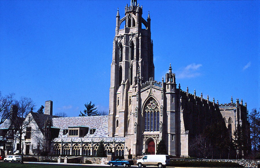

Kirk in the Hills
The area is the home of landmark churches including Kirk in the Hills Presbyterian on Long Lake Rd (Bloomfield Township) and Christ Church Cranbrook Episcopal, consecrated in 1928 as part of George Booth's plan for the Cranbrook Educational Community.[11] The Congregational Church of Birmingham United Church of Christ[12] was founded in Birmingham but moved to its present location in at 1000 Cranbrook Road (at Woodward Avenue) in Bloomfield Hills in 1966.[13] St. Hugo of the Hills Roman Catholic Church' was funded by Theodore F. MacManus (1872–1940) and his wife in memory of their deceased children, Hugo and Hubert. St. Hugo of the Hills Catholic Church was built from 1931–1936, with approval from Bishop Michael J. Gallagher, and was designed by Arthur DesRossiers.[14] Other churches include St. George Greek Orthodox, Bloomfield Hills Baptist, Beautiful Savior Lutheran Church (ELCA) on Adams Road (Bloomfield Township), Detroit Michigan Temple of The Church of Jesus Christ of Latter-day Saints, and Birmingham Unitarian Church on Woodward Avenue.[15][16]
Government[]
State officials
- Governor Rick Snyder (R)
- State Senator John Pappageorge (R) – 13th State Senate District
- State Representative Mike McCready (R) – 40th State House District
Federal officials
- Senator Carl Levin (D)
- Senator Debbie Stabenow (D)
- Representative Kerry Bentivolio (R) – 11th Congressional District
Geography[]
According to the United States Census Bureau, the city has a total area of 5.04 square miles (13.05 km2), of which 4.96 square miles (12.85 km2) is land and 0.08 square miles (0.21 km2) is water.[2]
Demographics[]
As of the 2005–2009 American Community Survey 5-Year Estimates,[17] there were 3,774 people, 1,570 households, and about 1,382 families residing in the city. The population density was 796.4 per square mile (307.3/km²). There were 1,628 housing units at an average density of 329.1 per square mile (127.0/km²). The racial makeup of the city was 89.1% White, 5.4% Asian, 4.3% Black, 0.8% from other races, and 0.4% from two or more races. Hispanic or Latino of any race were 2.2% of the population.
2010 census[]
As of the census[3] of 2010, there were 3,869 people, 1,489 households, and 1,116 families residing in the city. The population density was 780.0 inhabitants per square mile (301.2 /km2). There were 1,659 housing units at an average density of 334.5 per square mile (129.2 /km2). The racial makeup of the city was 87.3% White, 4.1% African American, 0.1% Native American, 6.7% Asian, 0.3% from other races, and 1.6% from two or more races. Hispanic or Latino of any race were 1.5% of the population.
There were 1,489 households of which 25.7% had children under the age of 18 living with them, 67.7% were married couples living together, 4.9% had a female householder with no husband present, 2.4% had a male householder with no wife present, and 25.1% were non-families. 21.8% of all households were made up of individuals and 13% had someone living alone who was 65 years of age or older. The average household size was 2.44 and the average family size was 2.84.
The median age in the city was 54.1 years. 19.9% of residents were under the age of 18; 4.8% were between the ages of 18 and 24; 11.8% were from 25 to 44; 33.5% were from 45 to 64; and 29.7% were 65 years of age or older. The gender makeup of the city was 49.0% male and 51.0% female.
2000 census[]
As of the census[5] of 2000, There were 1,520 households out of which 26.2% had children under the age of 18 living with them, 71.9% were married couples living together, 3.2% had a female householder with no husband present, and 23.2% were non-families. 21.1% of all households were made up of individuals and 10.3% had someone living alone who was 65 years of age or older. The average household size was 2.45 and the average family size was 2.84.
In the city the population was spread out with 19.7% under the age of 18, 3.8% from 18 to 24, 13.8% from 25 to 44, 39.0% from 45 to 64, and 23.8% who were 65 years of age or older. The median age was 52 years. For every 100 females there were 89.8 males. For every 100 females age 18 and over, there were 85.8 males.
The median income for a household in the city was $170,790, and the median income for a family was over $200,000. Males had a median income of $100,000 versus $52,273 for females. The per capita income for the city was $104,920. About 1.8% of families and 3.8% of the population were below the poverty line, including 5.3% of those under age 18 and 6.4% of those age 65 and over.
Education[]
Primary and secondary schools[]
Public schools[]
The city is served by the Bloomfield Hills School District (BHSD), a public school district based in neighboring Bloomfield Township, comprising the City of Bloomfield Hills, most of Bloomfield Township, and small parts of neighboring communities such as Auburn Hills, Troy, and West Bloomfield Township. Most schools within the district are in Bloomfield Township, but Lone Pine Elementary and West Hills Middle School are located in the eastern portion of West Bloomfield Township. The district operates four elementary schools, three middle schools, one traditional high school, several nontraditional high schools, a development center for special education students, a nature center, and a working farm.
The district operates four elementary schools: Conant Elementary (grades K-4), Eastover Elementary (grades K-4), Lone Pine Elementary (grades K-3), and Way Elementary (grades K-4). The district previously operated two additional elementary schools, Pine Lake and Hickory Grove, whose students were consolidated into the remaining four schools beginning with the 2009–2010 school year.
There are three middle schools in the district: Bloomfield Hills Middle School (grades 5–8), West Hills Middle School (grades 4–8) and East Hills Middle School (grades 5–8).
The sole district comprehensive high school is Bloomfield Hills High School, formed in 2013 by the mergers of Andover High School and Lahser High School.[18][19] Bloomfield Hills High School temporarily is operating grades 10–12 out of the former Lahser building while a new, permanent high school building is being constructed at the former Andover site. In the interim, the former Hickory Grove building is temporary home of the district's ninth grade academy. Buses shuttle students between the 9th grade campus and the main campus. The district is planning for students in grades 9–12 to move to the new Bloomfield Hills High School Building at the former Andover cite in fall 2015.
The district also offers two nontraditional high schools: Model High School, which currently operates out of the former Pine Lake Elementary building in West Bloomfield Township, and the Bowers Academy, an alternative high school which is located at the Charles L. Bowers Farm in Bloomfield Township, MI.
The district administers the International Academy, a tuition-free, public consortium high school in Bloomfield Township that hosts students from ten different public schools districts (including some Bloomfield Hills School District students). All IA students in grades 9–12 participate in the IB Diploma Program. Since the mid 2000s, Newsweek magazine has consistently ranked IA within the top twenty public high schools in the United States, including honoring it with the #1 ranking in 2003.
The district operates Wing Lake Developmental Center, in Bloomfield Township, to provide special education services for students in southeastern Oakland County.
Private schools[]
Bloomfield Hills is also home to many private schools. These include the nonsectarian Cranbrook Schools, Cranbrook Academy of Art, The Roeper School, and St. Hugo of the Hills Catholic School. The neighboring communities of Bloomfield Township and Beverly Hills have two single-sex Catholic schools: Brother Rice High School for boys and Marian High School for girls, as well as a private college-preparatory school, Detroit Country Day School.
Post-secondary education[]
Bloomfield Hills is home to the Cranbrook Academy of Art, one of the nation's leading graduate schools of architecture, art and design. It was founded by the Booths in 1932. By 1984, the New York Times would say that "the effect of Cranbrook and its graduates and faculty on the physical environment of this country has been profound ... Cranbrook, surely more than any other institution, has a right to think of itself as synonymous with contemporary American design."
Notable people[]
See also[]
- Oakland Hills Country Club
- Michigan locations by per capita income
References[]
- ^ "City of Bloomfield Hills". Bloomfieldhillsmi.net. http://www.bloomfieldhillsmi.net/.
- ^ a b "US Gazetteer files 2010". United States Census Bureau. http://www.census.gov/geo/www/gazetteer/files/Gaz_places_national.txt. Retrieved November 25, 2012.
- ^ a b "American FactFinder". United States Census Bureau. http://factfinder2.census.gov/faces/nav/jsf/pages/index.xhtml. Retrieved November 25, 2012.
- ^ "Population Estimates". United States Census Bureau. http://www.census.gov/popest/data/cities/totals/2012/SUB-EST2012.html. Retrieved June 3, 2013.
- ^ a b "American FactFinder". United States Census Bureau. http://factfinder2.census.gov. Retrieved 2008-01-31.
- ^ USGS GNIS: Bloomfield Hills, Michigan
- ^ Google Maps Distance Calculator, Draft Logic from Bloomfield Hills, Michigan to downtown Detroit
- ^ "Race, Hispanic or Latino, Age, and Housing Occupancy: 2010 Census Redistricting Data (Public Law 94-171) Summary File (QT-PL), Bloomfield Hills city, Michigan". U.S. Census Bureau, American FactFinder 2. http://factfinder2.census.gov. Retrieved August 18, 2011.
- ^ 1990 CPH-L-126. Median Family Income for Places with a Population of 2,500 to 9,999, Ranked Within the United States United States Census Bureau
- ^ "Table DP-3. Profile of Selected Economic Characteristics: 2000" (PDF). http://censtats.census.gov/data/MI/1602609180.pdf.
- ^ Christ Church Cranbrook web site
- ^ "Congregational Church of Birmingham web site". Ccbucc.org. http://www.ccbucc.org.
- ^ CCB web site
- ^ St. Hugo website
- ^ Birmingham Unitarian Church web site
- ^ "UUA web site". Uua.org. October 11, 2012. http://www.uua.org.
- ^ http://factfinder.census.gov.+"2005–2009 American Community Survey 5-Year Estimates". US Census Bureau. http://factfinder.census.gov/servlet/ACSSAFFFacts?_event=Search&geo_id=&_geoContext=&_street=&_county=bloomfield+hills&_cityTown=bloomfield+hills&_state=04000US26&_zip=&_lang=en&_sse=on&pctxt=fph&pgsl=010. Retrieved April 26, 2011.
- ^ "Home." Bloomfield Hills High School. Retrieved on July 30, 2013. "Bloomfield Hills High School Main Campus 3456 Lahser Road Bloomfield Hills, MI 48302" and "Bloomfield Hills High School 9th Grade Campus 2800 Lahser Bloomfield Hills, MI 48302"
- ^ "Bloomfield Township Street Map." (Archive) Bloomfield Township, Oakland County. Retrieved on July 30, 2013.
External links[]
| ||||||||||||||||||||||||||

| |||||||||||||||||||||||||||||||||||


|
Pontiac | Bloomfield Township, Auburn Hills | Rochester |
|
| West Bloomfield Township, Bloomfield Township, | Bloomfield Township, Troy | |||
 Bloomfield Hills | ||||
| Beverly Hills, Southfield | Bloomfield Township, Birmingham | Birmingham, Royal Oak |
| This page uses content from the English language Wikipedia. The original content was at Bloomfield Hills, Michigan. The list of authors can be seen in the page history. As with this Familypedia wiki, the content of Wikipedia is available under the Creative Commons License. |