| ||||||||||||||
| Cameron County, Texas | ||
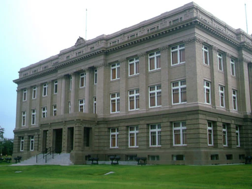
 The current Cameron County Courthouse in Brownsville.
| ||
| ||
 Location in the state of Texas | ||
 Texas's location in the U.S. | ||
| Founded | 1848 | |
|---|---|---|
| Seat | Brownsville | |
| Area - Total - Land - Water |
1,276 sq mi (3,305 km²) 906 sq mi (2,347 km²) 371 sq mi (961 km²), 29.03% | |
| Population - (2020) - Density |
421,017 370/sq mi (143/km²) | |
| Website | www.co.cameron.tx.us | |
Cameron County is the southernmost county located in the U.S. state of Texas. In 2020, its population was 421,017. Its county seat is Brownsville[1]. Cameron was founded in 1848. Cameron is named for Captain Ewen Cameron [1], a soldier during the Texas Revolution and in the ill-fated Mier Expedition.
Cameron County is part of the Brownsville–Harlingen Metropolitan Statistical Area as well as the Brownsville–Harlingen–Raymondville Combined Statistical Area.
Geography[]
According to the U.S. Census Bureau, the county has a total area of 1,276 square miles (3,304.8 km2), of which 906 square miles (2,346.5 km2) is land and 371 square miles (960.9 km2) (29.03%) is water.
Major highways[]
 U.S. Highway 77
US-77 is a is a freeway through Harlingen to Brownsville, blocks north of the International Border.
- U.S. Highway 83
US-83 is a Freeway through Harlingen and Brownsville.
- U.S. Highway 281
US-281 is called the 'Military Highway' through Cameron County, and runs roughly adjacent to the Rio Grande River and the Border.
- State Highway 4
- State Highway 48
- State Highway 100
- State Highway 107
Adjacent counties and municipios[]
- Willacy County, Texas (north)
- Hidalgo County, Texas (west)
- Matamoros Municipality, Tamaulipas, Mexico (south)
To the east, the county borders the Gulf of Mexico.
National protected areas[]
- Laguna Atascosa National Wildlife Refuge (part)
- Lower Rio Grande Valley National Wildlife Refuge (part)
- Palo Alto Battlefield National Historic Site
Demographics[]
As of the census[2] of 2000, there were 335,227 people[3], 97,267 households, and 79,953 families residing in the county. The population density was 370 people per square mile (143/km²). There were 119,654 housing units at an average density of 132 per square mile (51/km²). The racial makeup of the county was 80.29% White, 0.48% Black or African American, 0.44% Native American, 0.48% Asian, 0.03% Pacific Islander, 15.98% from other races, and 2.30% from two or more races. 84.34% of the population were Hispanic or Latino of any race.
There were 97,267 households out of which 45.80% had children under the age of 18 living with them, 60.80% were married couples living together, 17.40% had a female householder with no husband present, and 17.80% were non-families. 15.40% of all households were made up of individuals and 7.60% had someone living alone who was 65 years of age or older. The average household size was 3.40 and the average family size was 3.81.
In the county, the population was spread out with 33.80% under the age of 18, 10.50% from 18 to 24, 26.80% from 25 to 44, 17.80% from 45 to 64, and 11.10% who were 65 years of age or older. The median age was 29 years. For every 100 females there were 91.90 males. For every 100 females age 18 and over, there were 86.30 males.
The median income for a household in the county was $26,155, and the median income for a family was $27,853. Males had a median income of $22,755 versus $18,182 for females. The per capita income for the county was $10,960. About 28.20% of families and 33.10% of the population were below the poverty line, including 43.10% of those under age 18 and 22.90% of those age 65 or over.
A 2000 Texas A&M study stated that of the residents of Cameron County, 43% do not have basic literary skills.[4]
Communities[]
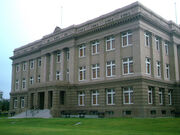
A picture of the Cameron County Courthouse (1912), the Dancy Building, in Brownsville, Texas which served as the County Courthouse before the construction of the current Courthouse. It was restored in 2006 and now houses County Court at Law No 1 as well as some county offices.
Cities[]
- Brownsville
- Harlingen
- La Feria
- Los Fresnos
- Palm Valley
- Port Isabel
- Rio Hondo
- San Benito
Towns[]
- Bayview
- Combes
- Indian Lake
- Laguna Vista
- Los Indios
- Primera
- Rancho Viejo
- Santa Rosa
- South Padre Island
Unincorporated areas[]
Census-designated places[]
|
|
|
Other unincorporated areas[]
- Arroyo City
- Rangerville
Government and infrastructure[]
U.S. Immigration and Customs Enforcement operates the Port Isabel Service Processing Center, which is located in an unincorporated area adjacent to Port Isabel-Cameron County Airport.[5]
Politics[]
Cameron County leans toward the Democratic Party in presidential elections. The last Republican to win the county was George W. Bush in 2004. Donald Trump's 2016 showing of 32.0% was the lowest received by a Republican candidate in the county since Alf Landon in 1936. However in 2020, Trump's performance of 43% was the best for a Republican in the county since 2004.
As of 2006, officeholders tend to be Democrats. As of 2006, about 20,000 to 30,000 people in Cameron County vote in primary elections, and presidential elections have higher turnouts. Politiqueras, women hired to help elderly people vote, are crucial in South Texas elections.
| Year | Republican | Democratic | Third party | |||
|---|---|---|---|---|---|---|
| No. | % | No. | % | No. | % | |
| 2020 | 49,032 | 42.89% | 64,063 | 56.04% | 1,231 | 1.08% |
| 2016 | 29,472 | 31.80% | 59,402 | 64.10% | 3,791 | 4.09% |
| 2012 | 26,099 | 33.94% | 49,975 | 64.99% | 821 | 1.07% |
| 2008 | 26,671 | 35.06% | 48,480 | 63.72% | 926 | 1.22% |
| 2004 | 34,801 | 50.32% | 33,998 | 49.16% | 357 | 0.52% |
| 2000 | 27,800 | 44.80% | 33,214 | 53.52% | 1,043 | 1.68% |
| 1996 | 18,434 | 32.63% | 34,891 | 61.76% | 3,168 | 5.61% |
| 1992 | 20,123 | 34.07% | 29,435 | 49.84% | 9,499 | 16.08% |
| 1988 | 24,263 | 43.68% | 30,972 | 55.75% | 317 | 0.57% |
| 1984 | 29,545 | 52.64% | 26,394 | 47.03% | 187 | 0.33% |
| 1980 | 22,041 | 47.62% | 23,200 | 50.12% | 1,044 | 2.26% |
| 1976 | 16,448 | 39.06% | 25,310 | 60.10% | 353 | 0.84% |
| 1972 | 20,816 | 60.69% | 13,340 | 38.89% | 144 | 0.42% |
| 1968 | 11,759 | 39.82% | 15,726 | 53.26% | 2,042 | 6.92% |
| 1964 | 9,531 | 37.14% | 16,056 | 62.57% | 72 | 0.28% |
| 1960 | 10,190 | 45.01% | 12,416 | 54.84% | 34 | 0.15% |
| 1956 | 11,952 | 56.85% | 8,829 | 42.00% | 241 | 1.15% |
| 1952 | 14,018 | 64.89% | 7,559 | 34.99% | 25 | 0.12% |
| 1948 | 4,689 | 39.54% | 6,778 | 57.15% | 392 | 3.31% |
| 1944 | 5,309 | 44.82% | 5,998 | 50.63% | 539 | 4.55% |
| 1940 | 3,370 | 35.73% | 6,035 | 63.98% | 28 | 0.30% |
| 1936 | 2,160 | 26.32% | 5,887 | 71.74% | 159 | 1.94% |
| 1932 | 1,785 | 19.87% | 7,146 | 79.53% | 54 | 0.60% |
| 1928 | 3,544 | 52.45% | 3,202 | 47.39% | 11 | 0.16% |
| 1924 | 1,266 | 34.52% | 2,225 | 60.68% | 176 | 4.80% |
| 1920 | 909 | 49.24% | 920 | 49.84% | 17 | 0.92% |
| 1916 | 420 | 24.48% | 1,260 | 73.43% | 36 | 2.10% |
| 1912 | 149 | 6.13% | 2,146 | 88.35% | 134 | 5.52% |
Education[]
Cameron County is served by several school districts. They include:
- Brownsville Independent School District
- Harlingen Consolidated Independent School District
- La Feria Independent School District
- Los Fresnos Consolidated Independent School District
- Lyford Consolidated Independent School District (partially)
- Point Isabel Independent School District
- Rio Hondo Independent School District
- San Benito Consolidated Independent School District
- Santa Maria Independent School District
- Santa Rosa Independent School District
In addition, residents are eligible to apply to South Texas Independent School District's magnet schools.
Radio stations[]
- KFRQ 94.5FM - Official Site
- KKPS 99.5FM - Official Site
- KNVO 101.1FM - Official Site
- KVLY 107.9FM - Official Site
Newspapers[]
- The Brownsville Herald (A Freedom Communications, Inc. newspaper based in Brownsville, TX) - Official Site
- Valley Morning Star (A Freedom Communications, Inc. newspaper based in Harlingen, TX) - Official Site
See also[]
- National Register of Historic Places listings in Cameron County, Texas
References[]
- ^ "Find a County". National Association of Counties. http://www.naco.org/Counties/Pages/FindACounty.aspx. Retrieved 2011-06-07.
- ^ "American FactFinder". United States Census Bureau. http://factfinder.census.gov. Retrieved 2008-01-31.
- ^ http://quickfacts.census.gov/qfd/states/48/48061.html
- ^ Clark, Steve. "Borders liquidation to bring down local Waldenbooks." The Brownsville Herald. July 20, 2011. Retrieved on July 21, 2011.
- ^ "Port Isabel Service Processing Center." U.S. Immigration and Customs Enforcement. Retrieved on July 21, 2010.
- ^ Leip, David. "Dave Leip's Atlas of U.S. Presidential Elections". http://uselectionatlas.org/RESULTS.
External links[]
- Cameron County government's website
- Cameron County in Handbook of Texas Online at the University of Texas

|
Willacy County |
| ||
| Hidalgo County | Gulf of Mexico | |||
 Cameron County, Texas | ||||
| Matamoros, Tamaulipas, Mexico |
| ||||||||||||||||||||


| This page uses content from the English language Wikipedia. The original content was at Cameron County, Texas. The list of authors can be seen in the page history. As with this Familypedia wiki, the content of Wikipedia is available under the Creative Commons License. |