| ||||||||||||||
- This article is about the county in Kansas. For other uses of "Chautauqua," see Chautauqua (disambiguation).
| Chautauqua County, Kansas | |
 Location in the state of Kansas | |
 Kansas's location in the U.S. | |
| Founded | March 25, 1875 |
|---|---|
| Named for | Chautauqua County, New York |
| Seat | Sedan |
| Area - Total - Land - Water |
644.83 sq mi (1,670 km²) 641.69 sq mi (1,662 km²) 3.14 sq mi (8 km²), 0.49% |
| Population - (2010) - Density |
3,669 6.2/sq mi (2.4/km²) |
| Time zone | Central: UTC-6/-5 |
Chautauqua County (county code CQ) is a county located in Southeast Kansas, in the Central United States. As of the 2010 census, the county population was 3,669.[1] Its county seat and most populous city is Sedan.[2] Chautauqua County is named for Chautauqua County, New York.
History[]
The first white settlers in the area that became Chautauqua County arrived in July 1868.
Chautauqua County was created by an act of the Kansas legislature on June 1, 1875 by the division of Howard County into Elk County (the northern half) and Chautauqua County (the southern half). At the time of its creation, the county's population was about 7,400.
Law and government[]
Although the Kansas Constitution was amended in 1986 to allow the sale of alcoholic liquor by the individual drink with the approval of voters, Chautauqua County remained a prohibition, or "dry", county, until 2008' when a county wide ballot measure was approved to allow individual liquor sales with a 30 percent food requirement[3]
Geography[]
According to the 2000 census, the county has a total area of 644.83 square miles (1,670.1 km2), of which 641.69 square miles (1,662.0 km2) (or 99.51%) is land and 3.14 square miles (8.1 km2) (or 0.49%) is water.[4]
Adjacent counties[]
- Elk County (north)
- Montgomery County (east)
- Washington County, Oklahoma (southeast)
- Osage County, Oklahoma (south)
- Cowley County (west)
Major highways[]
Sources: National Atlas,[5] U.S. Census Bureau[6]
- U.S. Route 166
- Kansas Highway 38
- Kansas Highway 99
Demographics[]
| Historical populations | |||
|---|---|---|---|
| Census | Pop. | %± | |
| 1880 | 11,072 | [7] | |
| 1890 | 12,297 | 11.1% | |
| 1900 | 11,804 | −4.0% | |
| 1910 | 11,429 | −3.2% | |
| 1920 | 11,598 | 1.5% | |
| 1930 | 10,352 | −10.7% | |
| 1940 | 9,233 | −10.8% | |
| 1950 | 7,376 | −20.1% | |
| 1960 | 5,956 | −19.3% | |
| 1970 | 4,642 | −22.1% | |
| 1980 | 5,016 | 8.1% | |
| 1990 | 4,407 | −12.1% | |
| 2000 | 4,359 | −1.1% | |
| 2010 | 3,669 | −15.8% | |

Population pyramid

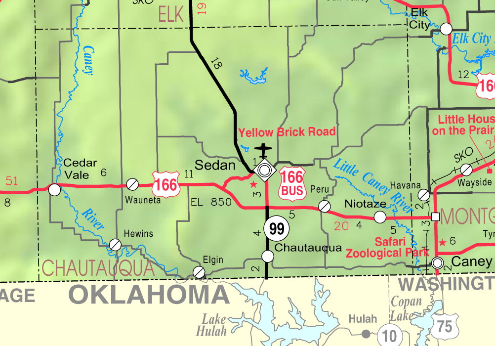
2005 KDOT Map of Chautauqua County (map legend)
As of the U.S. Census in 2000,[8] there were 4,359 people, 1,796 households, and 1,235 families residing in the county. The population density was 7 people per square mile (3/km²). There were 2,169 housing units at an average density of 3 per square mile (1/km²). The racial makeup of the county was 93.83% White, 0.30% Black or African American, 3.58% Native American, 0.07% Asian, 0.05% Pacific Islander, 0.34% from other races, and 1.84% from two or more races. Hispanic or Latino of any race were 1.35% of the population.
There were 1,796 households out of which 26.20% had children under the age of 18 living with them, 57.30% were married couples living together, 7.90% had a female householder with no husband present, and 31.20% were non-families. 29.40% of all households were made up of individuals and 16.40% had someone living alone who was 65 years of age or older. The average household size was 2.34 and the average family size was 2.87.
In the county the population was spread out with 23.40% under the age of 18, 6.10% from 18 to 24, 20.90% from 25 to 44, 25.20% from 45 to 64, and 24.30% who were 65 years of age or older. The median age was 45 years. For every 100 females there were 93.60 males. For every 100 females age 18 and over, there were 91.20 males.
The median income for a household in the county was $28,717, and the median income for a family was $33,871. Males had a median income of $25,083 versus $21,346 for females. The per capita income for the county was $16,280. About 9.00% of families and 12.20% of the population were below the poverty line, including 15.80% of those under age 18 and 10.60% of those age 65 or over.
Cities and towns[]
Incorporated cities[]
Name and population (2006 estimate):[9]
- Sedan, 1,222 (county seat)
- Cedar Vale, 646
- Peru, 166
- Niotaze, 111
- Chautauqua, 102
- Elgin, 75
Unincorporated places[]
- Cloverdale
- Grafton
- Hale
- Hewins
- Jonesburg
- Layton (no longer exists)
- Leeds (no longer exists)
- Lowe (Gibbs)
- Matanzas (no longer exists)
- Monett
- Moore (no longer exists)
- Osro (no longer exists)
- Rogers
- Wauneta
Townships[]
Chautauqua County is divided into twelve townships. None of the cities within the county are considered governmentally independent, and all figures for the townships include those of the cities. In the following table, the population center is the largest city (or cities) included in that township's population total, if it is of a significant size.
| Township | FIPS | Population center |
Population | Population density /km² (/sq mi) |
Land area km² (sq mi) |
Water area km² (sq mi) |
Water % | Geographic coordinates |
|---|---|---|---|---|---|---|---|---|
| Belleville | 05575 | 675 | 4 (11) | 155 (60) | 0 (0) | 0.14% | ||
| Caneyville | 10425 | 88 | 1 (2) | 144 (55) | 1 (0) | 0.38% | ||
| Center | 11575 | 75 | 1 (1) | 144 (56) | 1 (0) | 0.80% | ||
| Harrison | 30275 | 114 | 1 (2) | 142 (55) | 0 (0) | 0.14% | ||
| Hendricks | 31300 | 179 | 1 (3) | 142 (55) | 0 (0) | 0.05% | ||
| Jefferson | 35125 | Cedar Vale | 834 | 6 (15) | 144 (56) | 1 (0) | 0.45% | |
| Lafayette | 37650 | 65 | 0 (1) | 154 (59) | 2 (1) | 1.40% | ||
| Little Caney | 41525 | 353 | 3 (8) | 117 (45) | 0 (0) | 0.31% | ||
| Salt Creek | 62775 | 123 | 1 (3) | 127 (49) | 0 (0) | 0.34% | ||
| Sedan | 63775 | Sedan | 1,660 | 13 (34) | 128 (49) | 1 (0) | 0.65% | |
| Summit | 69025 | 106 | 1 (2) | 144 (56) | 1 (0) | 0.40% | ||
| Washington | 75550 | 87 | 1 (2) | 121 (47) | 1 (0) | 0.71% | ||
| Sources: "Census 2000 U.S. Gazetteer Files". U.S. Census Bureau, Geography Division. http://www.census.gov/geo/www/gazetteer/places2k.html. | ||||||||
Education[]
Unified school districts[]
See also[]
Information on this and other counties in Kansas
- List of counties in Kansas
- List of Kansas county name etymologies
- National Register of Historic Places listings in Kansas
- Kansas locations by per capita income
Other information for Kansas
- List of cities in Kansas
- List of unified school districts in Kansas
- List of colleges and universities in Kansas
References[]
- ^ "2010 County Population and Housing Occupancy Status". U.S. Census Bureau. http://factfinder2.census.gov/faces/tableservices/jsf/pages/productview.xhtml?pid=DEC_10_PL_GCTPL2.ST05&prodType=table. Retrieved March 31, 2011.
- ^ "Find a County". National Association of Counties. http://www.naco.org/Counties/Pages/FindACounty.aspx. Retrieved 2011-06-07.
- ^ "Map of Wet and Dry Counties". Alcoholic Beverage Control, Kansas Department of Revenue. November 2006. http://www.ksrevenue.org/abcwetdrymap.htm. Retrieved 2007-12-26.
- ^ "Census 2000 U.S. Gazetteer Files: Counties". United States Census. http://www.census.gov/tiger/tms/gazetteer/county2k.txt. Retrieved 2011-02-13.
- ^ National Atlas
- ^ U.S. Census Bureau TIGER shape files
- ^ The counties of Chautauqua and Elk were organized from parts of Howard County in 1875. The census populations for Howard were 2,794 in 1870 and 19 in 1860.
- ^ "American FactFinder". United States Census Bureau. http://factfinder.census.gov. Retrieved 2008-01-31.
- ^ "Population Estimates". U.S. Census Bureau, Population Division. http://www.census.gov/popest/estimates.php. Annual estimates of the population to 2006-07-01. Released 2007-06-28.
Further reading[]
- History of the State of Kansas; William G. Cutler; A.T. Andreas Publisher; 1883. (Online HTML eBook)
- Kansas : A Cyclopedia of State History, Embracing Events, Institutions, Industries, Counties, Cities, Towns, Prominent Persons, Etc; 3 Volumes; Frank W. Blackmar; Standard Publishing Co; 944 / 955 / 824 pages; 1912. (Volume1 - Download 54MB PDF eBook),(Volume2 - Download 53MB PDF eBook), (Volume3 - Download 33MB PDF eBook)
External links[]
- County
- Maps
- Chautauqua County Map, KDOT
- Kansas Highway Map, KDOT
- Kansas Railroad Map, KDOT
- Kansas School District Boundary Map, KSDE

|
Elk County |
| ||
| Cowley County | Montgomery County | |||
 Chautauqua County, Kansas | ||||
| Osage County, Oklahoma | Washington County, Oklahoma |
| |||||
| This page uses content from the English language Wikipedia. The original content was at Chautauqua County, Kansas. The list of authors can be seen in the page history. As with this Familypedia wiki, the content of Wikipedia is available under the Creative Commons License. |