No edit summary |
m (update from Wikipedia) |
||
| (One intermediate revision by the same user not shown) | |||
| Line 1: | Line 1: | ||
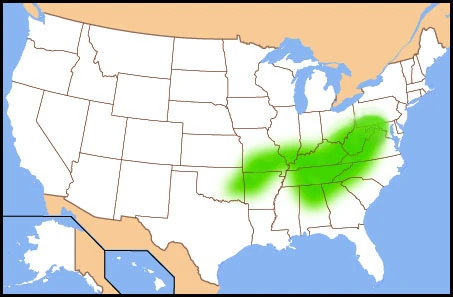
| ⚫ | The '''[[Cincinnati]]-[[Northern Kentucky]] metropolitan area''' (aka Greater Cincinnati) is a [[metropolitan area]] that includes counties in the U.S. states of [[Ohio]], [[Kentucky]] and [[Indiana]], centered around the city of [[Cincinnati, Ohio|Cincinnati]], [[Ohio]]. The [[United States Census]] defines the metropolitan area as the Cincinnati-Middletown Metropolitan Statistical Area (MSA). As of the [[United States Census, 2010|2010 census]], the MSA had a population of 2,130,151, the largest metro in Ohio and 27th largest in the United States.<ref>[[Table of United States Metropolitan Statistical Areas]]</ref> |
||
| − | [[Image:Greatercincinnaticounties.png|thumb|right|300px|The Cincinnati/Northern Kentucky MSA]] |
||
| ⚫ | The Census also defines the Cincinnati-Middletown-Wilmington Combined Statistical Area (CSA), which adds the [[Wilmington, Ohio]] Micropolitan Statistical Area to the metropolitan area for a 2009 estimated population of 2,214,954.<ref name="ReferenceA">[http://www.census.gov/popest/states/NST-ann-est.html Population Estimates]{{dead link|date=May 2012}}</ref> |
||
| − | |||
| ⚫ | The '''[[Cincinnati]]-[[Northern Kentucky]] metropolitan area''' (aka Greater Cincinnati) is a [[metropolitan area]] that includes counties in the U.S. states of [[Ohio]], [[Kentucky]] and [[Indiana]]. The [[United States Census]] defines the metropolitan area as the Cincinnati-Middletown Metropolitan Statistical Area (MSA). As of the [[United States Census, 2010|2010 census]], the MSA had a population of 2,130,151.<ref> |
||
| ⚫ | The Census also defines the Cincinnati-Middletown-Wilmington Combined Statistical Area (CSA), which adds the [[Wilmington, Ohio]] Micropolitan Statistical Area to the metropolitan area for a 2009 estimated population of 2,214,954.<ref name="ReferenceA">[http://www.census.gov/popest/states/NST-ann-est.html Population Estimates |
||
The Cincinnati – Northern Kentucky metropolitan area is also considered part of the [[Great Lakes Megalopolis]]. |
The Cincinnati – Northern Kentucky metropolitan area is also considered part of the [[Great Lakes Megalopolis]]. |
||
| − | ==The |
+ | ==The suburbs== |
| − | The suburbs of Cincinnati and Northern Kentucky can range in population from extremely small to as many as 40,000+ citizens. Many suburbs are their own little towns (e.g. Batavia, Ohio) but many are considered townships and counties.< |
+ | The suburbs of Cincinnati and Northern Kentucky can range in population from extremely small to as many as 40,000+ citizens. Many suburbs are their own little towns (e.g. [[Batavia, Ohio|Batavia]]) but many are considered townships and counties.<br> |
| − | [[Adams County, Ohio|Adams County]] - population: estimated 28,213.<ref> |
+ | [[Adams County, Ohio|Adams County]] - population: estimated 28,213.<ref>{{cite web|url=http://quickfacts.census.gov/qfd/states/39/39001.html |title=Adams County QuickFacts from the US Census Bureau |publisher=Quickfacts.census.gov |date= |accessdate=2012-05-14}}</ref><br/> |
| − | [[Amelia, Ohio|Amelia]] - population:3,530 |
+ | [[Amelia, Ohio|Amelia]] - population:3,530<ref>[http://www.bestplaces.net/City/Amelia-Ohio.aspx Best Places to Live in Amelia, Ohio], bestplaces.net</ref><br/> |
| − | [[Anderson Township, Ohio|Anderson Township]] - population:37,700 |
+ | [[Anderson Township, Ohio|Anderson Township]] - population:37,700<ref>[http://www.bestplaces.net/city/Anderson_township-Ohio.aspx Best Places to Live in Anderson township, Ohio], bestplaces.net</ref><br/> |
| − | [[Arlington Heights, Ohio|Arlington Heights]] - population:830<ref>[http://www.bestplaces.net/city/Arlington_Heights-Ohio.aspx Best Places to Live in Arlington Heights, Ohio], bestplaces.net</ref><br |
+ | [[Arlington Heights, Ohio|Arlington Heights]] - population:830<ref>[http://www.bestplaces.net/city/Arlington_Heights-Ohio.aspx Best Places to Live in Arlington Heights, Ohio], bestplaces.net</ref><br/> |
| − | [[Bethel, Ohio|Bethel]] - population:2,633<ref>[http://www.bestplaces.net/city/Bethel-Ohio.aspx Best Places to Live in Bethel, Ohio], bestplaces.net</ref><br |
+ | [[Bethel, Ohio|Bethel]] - population:2,633<ref>[http://www.bestplaces.net/city/Bethel-Ohio.aspx Best Places to Live in Bethel, Ohio], bestplaces.net</ref><br/> |
| − | [[Blue Ash, Ohio|Blue Ash]] - population:12,767<ref>[http://www.bestplaces.net/city/Blue_Ash-Ohio.aspx Best Places to Live in Blue_Ash, Ohio], bestplaces.net</ref><br |
+ | [[Blue Ash, Ohio|Blue Ash]] - population:12,767<ref>[http://www.bestplaces.net/city/Blue_Ash-Ohio.aspx Best Places to Live in Blue_Ash, Ohio], bestplaces.net</ref><br/> |
| − | [[Cherry Grove, Ohio|Cherry Grove]] - population:4,144<ref>[http://www.bestplaces.net/city/Cherry_Grove-Ohio.aspx Best Places to Live in Cherry Grove, Ohio], bestplaces.net</ref><br |
+ | [[Cherry Grove, Ohio|Cherry Grove]] - population:4,144<ref>[http://www.bestplaces.net/city/Cherry_Grove-Ohio.aspx Best Places to Live in Cherry Grove, Ohio], bestplaces.net</ref><br/> |
| − | [[Cheviot, Ohio|Cheviot]] - population:8,280<ref>[http://www.bestplaces.net/city/Cheviot-Ohio.aspx Best Places to Live in Cheviot, Ohio], bestplaces.net</ref><br |
+ | [[Cheviot, Ohio|Cheviot]] - population:8,280<ref>[http://www.bestplaces.net/city/Cheviot-Ohio.aspx Best Places to Live in Cheviot, Ohio], bestplaces.net</ref><br/> |
| − | [[Cleves, Ohio|Cleves]] - population:2,600<ref>[http://www.bestplaces.net/city/Cleves-Ohio.aspx Best Places to Live in Cleves, Ohio], bestplaces.net</ref><br |
+ | [[Cleves, Ohio|Cleves]] - population:2,600<ref>[http://www.bestplaces.net/city/Cleves-Ohio.aspx Best Places to Live in Cleves, Ohio], bestplaces.net</ref><br/> |
| − | [[Colerain Township, Hamilton County, Ohio|Colerain]] - population:60,144<ref>[http://www.bestplaces.net/city/Colerain-Ohio.aspx Best Places to Live in Colerain, Ohio], bestplaces.net</ref><br |
+ | [[Colerain Township, Hamilton County, Ohio|Colerain]] - population:60,144<ref>[http://www.bestplaces.net/city/Colerain-Ohio.aspx Best Places to Live in Colerain, Ohio], bestplaces.net</ref><br/> |
| − | [[Covington, Kentucky|Covington]] - population:43,370<ref>[http://www.bestplaces.net/city/Covington-Kentucky.aspx Best Places to Live in Covington, Kentucky], bestplaces.net</ref><br |
+ | [[Covington, Kentucky|Covington]] - population:43,370<ref>[http://www.bestplaces.net/city/Covington-Kentucky.aspx Best Places to Live in Covington, Kentucky], bestplaces.net</ref><br/> |
| − | [[Deerfield Township, Warren County, Ohio|Deerfield Township]] - population:30,500<ref>[http://www.bestplaces.net/city/Deerfield_township_(Warren_county)-Ohio.aspx Best Places to Live in Deerfield township (Warren county), Ohio], bestplaces.net</ref><br |
+ | [[Deerfield Township, Warren County, Ohio|Deerfield Township]] - population:30,500<ref>[http://www.bestplaces.net/city/Deerfield_township_(Warren_county)-Ohio.aspx Best Places to Live in Deerfield township (Warren county), Ohio], bestplaces.net</ref><br/> |
| − | [[ |
+ | [[Deer Park, Ohio|Deer Park]] - population:5,736<ref>[http://www.bestplaces.net/people/city/ohio/deer_park Best Places to Live in Deer_Park, Ohio], bestplaces.net</ref><br/> |
| + | [[Erlanger, Kentucky|Erlanger]] - population:18,368 |
||
| ⚫ | |||
| − | [[ |
+ | [[Fairfield Township, Butler County, Ohio|Fairfield Township]] - population:17,171<ref>[http://www.bestplaces.net/city/Fairfield_township_(Butler_county)-Ohio.aspx Best Places to Live in Fairfield township (Butler county), Ohio], bestplaces.net</ref><br/> |
| ⚫ | |||
| ⚫ | [[Fort Thomas, Kentucky|Fort Thomas]] - population:16,495 |
||
| + | [[Florence, Kentucky|Florence]] - population:28,381<ref>[http://www.florence-ky.gov/docs/admin/demographics2010.pdf About the City of Florence]{{dead link|date=May 2012}}</ref><br/> |
||
| ⚫ | |||
| ⚫ | [[Fort Thomas, Kentucky|Fort Thomas]] - population:16,495<ref>{{cite web|url=http://factfinder.census.gov/servlet/SAFFFacts?_event=Search&geo_id=01000US&_geoContext=&_street=&_county=&_cityTown=Fort+Thomas&_state=04000US21 |title=Fort Thomas city, Kentucky - Fact Sheet - American FactFinder |publisher=Factfinder.census.gov |date= |accessdate=2012-05-14}}</ref><br/> |
||
| ⚫ | |||
| − | + | [[Green Township, Hamilton County, Ohio|Green Township]] - population: 61,285<ref>[http://www.bestplaces.net/city/Green_township_(Hamilton_county)-Ohio.aspx Best Places to Live in Green township (Hamilton county), Ohio], bestplaces.net</ref> (CDP breakdown below) |
|
| − | *[[ |
+ | *[[Bridgetown North, Ohio|Bridgetown]] - population: 12,164<ref>[http://www.bestplaces.net/city/Bridgetown_North-Ohio.aspx Best Places to Live in Bridgetown North, Ohio], bestplaces.net</ref> |
| ⚫ | |||
| ⚫ | |||
*[[Mack, Ohio|Mack]] - population: 9,570,<ref>[http://www.bestplaces.net/city/Mack_North-Ohio.aspx Best Places to Live in Mack North, Ohio], bestplaces.net</ref><ref>[http://www.bestplaces.net/city/Mack_South-Ohio.aspx Best Places to Live in Mack South, Ohio], bestplaces.net</ref> |
*[[Mack, Ohio|Mack]] - population: 9,570,<ref>[http://www.bestplaces.net/city/Mack_North-Ohio.aspx Best Places to Live in Mack North, Ohio], bestplaces.net</ref><ref>[http://www.bestplaces.net/city/Mack_South-Ohio.aspx Best Places to Live in Mack South, Ohio], bestplaces.net</ref> |
||
*[[Monfort Heights, Ohio|Monfort Heights]] - population: 8,693,<ref>[http://www.bestplaces.net/city/Monfort_Heights_East-Ohio.aspx Best Places to Live in Monfort_Heights_East, Ohio], bestplaces.net</ref><ref>[http://www.bestplaces.net/city/Monfort_Heights_South-Ohio.aspx Best Places to Live in Monfort Heights South, Ohio], bestplaces.net</ref> |
*[[Monfort Heights, Ohio|Monfort Heights]] - population: 8,693,<ref>[http://www.bestplaces.net/city/Monfort_Heights_East-Ohio.aspx Best Places to Live in Monfort_Heights_East, Ohio], bestplaces.net</ref><ref>[http://www.bestplaces.net/city/Monfort_Heights_South-Ohio.aspx Best Places to Live in Monfort Heights South, Ohio], bestplaces.net</ref> |
||
*[[White Oak, Ohio|White Oak]] - population: 6,537,<ref>[http://www.bestplaces.net/city/White_Oak_West-Ohio.aspx Best Places to Live in White Oak_West, Ohio], bestplaces.net</ref><ref>[http://www.bestplaces.net/city/White_Oak_East-Ohio.aspx Best Places to Live in White Oak East, Ohio], bestplaces.net</ref> |
*[[White Oak, Ohio|White Oak]] - population: 6,537,<ref>[http://www.bestplaces.net/city/White_Oak_West-Ohio.aspx Best Places to Live in White Oak_West, Ohio], bestplaces.net</ref><ref>[http://www.bestplaces.net/city/White_Oak_East-Ohio.aspx Best Places to Live in White Oak East, Ohio], bestplaces.net</ref> |
||
| − | [[Goshen, Ohio|Goshen]] - population:12,800<ref>[http://www.bestplaces.net/city/Goshen-Ohio.aspx Best Places to Live in Goshen, Ohio], bestplaces.net</ref><br |
+ | [[Goshen, Ohio|Goshen]] - population:12,800<ref>[http://www.bestplaces.net/city/Goshen-Ohio.aspx Best Places to Live in Goshen, Ohio], bestplaces.net</ref><br/> |
| − | [[Hamilton, Ohio|Hamilton]] - population:62,000<ref>[http://www.bestplaces.net/city/Hamilton-Ohio.aspx Best Places to Live in Hamilton, Ohio], bestplaces.net</ref><br |
+ | [[Hamilton, Ohio|Hamilton]] - population:62,000<ref>[http://www.bestplaces.net/city/Hamilton-Ohio.aspx Best Places to Live in Hamilton, Ohio], bestplaces.net</ref><br/> |
| − | [[Harrison, Ohio|Harrison]] - population:14,000<ref>[http://www.bestplaces.net/city/Harrison_township_(Hamilton_county)-Ohio.aspx Best Places to Live in Harrison township (Hamilton county), Ohio], bestplaces.net</ref><br |
+ | [[Harrison, Ohio|Harrison]] - population:14,000<ref>[http://www.bestplaces.net/city/Harrison_township_(Hamilton_county)-Ohio.aspx Best Places to Live in Harrison township (Hamilton county), Ohio], bestplaces.net</ref><br/> |
| + | [[Independence, Kentucky|Independence]] - population:24,757 |
||
| ⚫ | |||
| − | [[Indian Hill, Ohio|Indian Hill]] - population:6,000<ref>[http://www.bestplaces.net/city/The_Village_of_Indian_Hill-Ohio.aspx Best Places to Live in The Village of Indian Hill, Ohio], bestplaces.net</ref><br |
+ | [[Indian Hill, Ohio|Indian Hill]] - population:6,000<ref>[http://www.bestplaces.net/city/The_Village_of_Indian_Hill-Ohio.aspx Best Places to Live in The Village of Indian Hill, Ohio], bestplaces.net</ref><br/> |
| − | [[Kenwood, Ohio|Kenwood]] - population:6,800<ref>[http://www.bestplaces.net/city/Kenwood-Ohio.aspx Best Places to Live in Kenwood, Ohio], bestplaces.net</ref><br |
+ | [[Kenwood, Ohio|Kenwood]] - population:6,800<ref>[http://www.bestplaces.net/city/Kenwood-Ohio.aspx Best Places to Live in Kenwood, Ohio], bestplaces.net</ref><br/> |
| − | [[Lebanon, Ohio|Lebanon]] - population:20,500<ref>[http://www.bestplaces.net/city/Lebanon-Ohio.aspx Best Places to Live in Lebanon, Ohio], bestplaces.net</ref><br |
+ | [[Lebanon, Ohio|Lebanon]] - population:20,500<ref>[http://www.bestplaces.net/city/Lebanon-Ohio.aspx Best Places to Live in Lebanon, Ohio], bestplaces.net</ref><br/> |
| − | [[Liberty Township, Butler County, Ohio|Liberty Township]] - population:25,200<ref>[http://www.bestplaces.net/city/Liberty_township_(Butler_county)-Ohio.aspx Best Places to Live in Liberty township (Butler county), Ohio], bestplaces.net</ref><br |
+ | [[Liberty Township, Butler County, Ohio|Liberty Township]] - population:25,200<ref>[http://www.bestplaces.net/city/Liberty_township_(Butler_county)-Ohio.aspx Best Places to Live in Liberty township (Butler county), Ohio], bestplaces.net</ref><br/> |
| − | [[Loveland, Ohio|Loveland]] - population:11,500<ref>[http://www.bestplaces.net/city/Loveland-Ohio.aspx Best Places to Live in Loveland, Ohio], bestplaces.net</ref><br |
+ | [[Loveland, Ohio|Loveland]] - population:11,500<ref>[http://www.bestplaces.net/city/Loveland-Ohio.aspx Best Places to Live in Loveland, Ohio], bestplaces.net</ref><br/> |
| − | [[Madeira, Ohio|Madeira]] - population:9,022<ref>http://madeiracity.com/documents/Community/About%20Madeira%20Revisons.PDF</ref><br |
+ | [[Madeira, Ohio|Madeira]] - population:9,022<ref>[http://madeiracity.com/documents/Community/About%20Madeira%20Revisons.PDF ]{{dead link|date=May 2012}}</ref><br/> |
| − | [[Mariemont, Ohio|Mariemont]] - population:3,100<ref>[http://www.bestplaces.net/city/Mariemont-Ohio.aspx Best Places to Live in Mariemont, Ohio], bestplaces.net</ref><br |
+ | [[Mariemont, Ohio|Mariemont]] - population:3,100<ref>[http://www.bestplaces.net/city/Mariemont-Ohio.aspx Best Places to Live in Mariemont, Ohio], bestplaces.net</ref><br/> |
| − | [[Mason, Ohio|Mason]] - population:30,000<ref>[http://www.bestplaces.net/city/Mason-Ohio.aspx Best Places to Live in Mason, Ohio], bestplaces.net</ref><br |
+ | [[Mason, Ohio|Mason]] - population:30,000<ref>[http://www.bestplaces.net/city/Mason-Ohio.aspx Best Places to Live in Mason, Ohio], bestplaces.net</ref><br/> |
| − | [[Middletown, Ohio]] - population: 51,605<br |
+ | [[Middletown, Ohio]] - population: 51,605<br/> |
| − | [[Milford, Ohio|Milford]] - population:6,300<ref>[http://www.bestplaces.net/city/Milford-Ohio.aspx Best Places to Live in Milford, Ohio], bestplaces.net</ref><br |
+ | [[Milford, Ohio|Milford]] - population:6,300<ref>[http://www.bestplaces.net/city/Milford-Ohio.aspx Best Places to Live in Milford, Ohio], bestplaces.net</ref><br/> |
| − | [[Montgomery, Ohio|Montgomery]] - population:10,200<ref>[http://www.bestplaces.net/city/Montgomery-Ohio.aspx Best Places to Live in Montgomery, Ohio], bestplaces.net</ref><br |
+ | [[Montgomery, Ohio|Montgomery]] - population:10,200<ref>[http://www.bestplaces.net/city/Montgomery-Ohio.aspx Best Places to Live in Montgomery, Ohio], bestplaces.net</ref><br/> |
| − | [[New Richmond, Ohio|New Richmond]] - population:2,500<ref>[http://www.bestplaces.net/city/New_Richmond-Ohio.aspx Best Places to Live in New Richmond, Ohio], bestplaces.net</ref><br |
+ | [[New Richmond, Ohio|New Richmond]] - population:2,500<ref>[http://www.bestplaces.net/city/New_Richmond-Ohio.aspx Best Places to Live in New Richmond, Ohio], bestplaces.net</ref><br/> |
| ⚫ | |||
| ⚫ | |||
| − | [[ |
+ | [[North College Hill, Ohio|North College Hill]] - population:9,500<ref>[http://www.bestplaces.net/city/North_College_Hill-Ohio.aspx Best Places to Live in North College Hill, Ohio], bestplaces.net</ref><br/> |
| ⚫ | |||
| ⚫ | |||
| + | [[Oxford, Ohio|Oxford]] - population:21,943<br/> |
||
| − | [[Pierce Township, Ohio|Pierce Township]] - population:13,500<ref>[http://www.bestplaces.net/city/Pierce_township-Ohio.aspx Best Places to Live in Pierce township, Ohio], bestplaces.net</ref><br /> |
||
| ⚫ | |||
| − | [[Silverton, Ohio|Silverton]] - population:5,178<ref> |
+ | [[Silverton, Ohio|Silverton]] - population:5,178<ref>{{cite web|url=http://factfinder.census.gov/servlet/SAFFFacts?_event=ChangeGeoContext&geo_id=16000US3972522&_geoContext=01000US&_street=&_county=hamilton&_cityTown=silverton&_state=04000US39&_zip=&_lang=en&_sse=on&ActiveGeoDiv=&_useEV=&pctxt=fph&pgsl=010&_submenuId=factsheet_1&ds_name=DEC_2000_SAFF&_ci_nbr=null&qr_name=null®=null%3Anull&_keyword=&_industry= |title=Silverton city, Ohio - Fact Sheet - American FactFinder |publisher=Factfinder.census.gov |date= |accessdate=2012-05-14}}</ref><br/> |
| ⚫ | |||
| − | [[ |
+ | [[Springboro, Ohio|Springboro]] (Partial) - population:17,500<ref>[http://www.bestplaces.net/city/Springboro-Ohio.aspx Best Places to Live in Springboro, Ohio], bestplaces.net</ref><br/> |
| ⚫ | |||
| − | |||
| + | [[Union, Kentucky|Union]] - population:5,379<br/> |
||
[[West Chester Township, Butler County, Ohio|West Chester Township]] - population 57,123 |
[[West Chester Township, Butler County, Ohio|West Chester Township]] - population 57,123 |
||
==General climate== |
==General climate== |
||
| − | The Cincinnati-Northern Kentucky metropolitan area is located within a climatic transition zone. The southern area of the region, from roughly about the Ohio River, is at the extreme northern limit of the [[humid subtropical climate]]; the north part of the region is on the extreme southern cusp of the [[humid continental climate]]. Evidence of both humid subtropical climate and humid continental climate can be found here, particularly noticeable by the presence of plants indicative of each climatic region; for example, the [[Southern magnolia]], [[Crape-myrtle]], [[Aucuba]], and [[Needle palm]] from the subtropics and the [[Blue spruce]], [[Maple]], and [[Eastern Hemlock]] from cooler regions. Within the area, the USDA climate zone rating can vary from as warm as zone 7 and 6b [http://www.ahs.org/pdfs/USDA_Map_3.03.pdf] to as cool as zone 5b [http://www.usna.usda.gov/Hardzone/ushzmap.html], with the warmest areas tending to be found closest to the [[Ohio River]]; individual [[microclimate]]s of even cooler and warmer temperature may occur in the area but are too small to be considered in the overall climate zone rating. The [[wall lizard]], introduced from Italy in the 1950s, is an example of fauna in the area that lends a subtropical ambiance to the southern and central area of the region. |
+ | The Cincinnati-Northern Kentucky metropolitan area is located within a climatic transition zone. The southern area of the region, from roughly about the Ohio River, is at the extreme northern limit of the [[humid subtropical climate]]; the north part of the region is on the extreme southern cusp of the [[humid continental climate]]. Evidence of both humid subtropical climate and humid continental climate can be found here, particularly noticeable by the presence of plants indicative of each climatic region; for example, the [[Southern magnolia]], [[Crape-myrtle]], [[Aucuba]], and [[Needle palm]] from the subtropics and the [[Blue spruce]], [[Maple]], and [[Eastern Hemlock]] from cooler regions. Within the area, the USDA climate zone rating can vary from as warm as zone 7 and 6b [http://www.ahs.org/pdfs/USDA_Map_3.03.pdf] to as cool as zone 5b [http://www.usna.usda.gov/Hardzone/ushzmap.html], with the warmest areas tending to be found closest to the [[Ohio River]]; individual [[microclimate]]s of even cooler and warmer temperature may occur in the area but are too small to be considered in the overall climate zone rating. The [[common wall lizard]], introduced from Italy in the 1950s, is an example of fauna in the area that lends a subtropical ambiance to the southern and central area of the region. |
Significant moderating variables for the overall climate are: |
Significant moderating variables for the overall climate are: |
||
| Line 68: | Line 69: | ||
North- Great Miami River, the area is situated on a glaciated flat plateau, the Miami Valley, and some urban heat island effect in the immediate area of downtown Dayton and Hamilton. |
North- Great Miami River, the area is situated on a glaciated flat plateau, the Miami Valley, and some urban heat island effect in the immediate area of downtown Dayton and Hamilton. |
||
| ⚫ | |||
| − | |||
Traveling through the region from North to South, a subtle but interesting change in climate can be observed and is most evidenced by the gradual increase in the occurrence of subtropical indicator plants in the landscape (most noticeable are the Southern Magnolia and [[Mimosa]] trees, the [[needle palm]] also may be found as a winter hardy landscape specimen in yards near the Ohio River). Also, in the winter there is usually a significant difference in snowfall/ice/rain in the region going from north to south. |
Traveling through the region from North to South, a subtle but interesting change in climate can be observed and is most evidenced by the gradual increase in the occurrence of subtropical indicator plants in the landscape (most noticeable are the Southern Magnolia and [[Mimosa]] trees, the [[needle palm]] also may be found as a winter hardy landscape specimen in yards near the Ohio River). Also, in the winter there is usually a significant difference in snowfall/ice/rain in the region going from north to south. |
||
| ⚫ | |||
| ⚫ | |||
| + | {{-}} |
||
| + | The area is vulnerable to occasional severe weather - thunderstorms, large hail and sometimes tornadoes. |
||
| ⚫ | |||
==Census Designation History== |
==Census Designation History== |
||
| Line 79: | Line 81: | ||
The Cincinnati, OH-KY-IN MSA was originally formed by the [[United States Census Bureau]] in 1950 and consisted of the Kentucky counties of [[Campbell County, Kentucky|Campbell]] and [[Kenton County, Kentucky|Kenton]] and the Ohio county of [[Hamilton County, Ohio|Hamilton]]. As surrounding counties saw an increase in their population densities and the number of their residents employed within Hamilton County, they met Census criteria to be added to the MSA. The Hamilton-Middletown, OH MSA was also formed in 1950 and consisted solely of [[Butler County, Ohio]]. |
The Cincinnati, OH-KY-IN MSA was originally formed by the [[United States Census Bureau]] in 1950 and consisted of the Kentucky counties of [[Campbell County, Kentucky|Campbell]] and [[Kenton County, Kentucky|Kenton]] and the Ohio county of [[Hamilton County, Ohio|Hamilton]]. As surrounding counties saw an increase in their population densities and the number of their residents employed within Hamilton County, they met Census criteria to be added to the MSA. The Hamilton-Middletown, OH MSA was also formed in 1950 and consisted solely of [[Butler County, Ohio]]. |
||
| − | In 1990, the Census changed designation of the areas known as MSAs to Primary Metropolitan Statistical Area (PMSA), and a new Consolidated Metropolitan Statistical Area (CMSA) grouping was created. From 1990 through 2005, the Cincinnati-Hamilton-Middletown CMSA included the Cincinnati-Hamilton, OH-KY-IN PMSA and the Hamilton-Middletown, OH PMSA. |
+ | In 1990, the Census changed designation of the areas known as MSAs to Primary Metropolitan Statistical Area (PMSA), and a new Consolidated Metropolitan Statistical Area (CMSA) grouping was created. From 1990 through 2005, the Cincinnati-Hamilton-Middletown CMSA included the Cincinnati-Hamilton, OH-KY-IN PMSA and the Hamilton-Middletown, OH PMSA. |
| − | As of December 2005, Census terminology changed again, eliminating the PMSA/CMSA terminology. Consolidated Statistical Areas (CSA) combine more than one Core Based Statistical Area (CBSA). Newly defined MSAs (Metropolitan) and µSAs (Micropolitan) Statistical Areas are CBSAs. The Cincinnati-Middletown-Wilmington CSA includes the Cincinnati-Middletown MSA (defined as the old Cincinnati-Hamilton-Middletown CMSA), and Wilmington, OH USA ([[Clinton County, Ohio]]). |
+ | As of December 2005, Census terminology changed again, eliminating the PMSA/CMSA terminology. Consolidated Statistical Areas (CSA) combine more than one Core Based Statistical Area (CBSA). Newly defined MSAs (Metropolitan) and µSAs (Micropolitan) Statistical Areas are CBSAs. The Cincinnati-Middletown-Wilmington CSA includes the Cincinnati-Middletown MSA (defined as the old Cincinnati-Hamilton-Middletown CMSA), and Wilmington, OH USA ([[Clinton County, Ohio]]). |
| − | ==Population |
+ | ==Population growth== |
| − | The |
+ | The metropolitan area's population has grown 8.1 percent between Census 2000 and the 2009 Census population estimate, just under the national population growth rate of 9.2 percent over the same period. This growth rate is about in the middle of the growth rates of other similarly sized mid western metropolitan areas. For example, the Cleveland metropolitan area lost approximately 2% of population, while Louisville gained 8%, Columbus gained 12%, and Indianapolis gained 14% over the same time period. |
| − | The 2009 population estimate from the US Census classifies population changes between natural population increases (number of births minus number of deaths) and net migration (the difference between people moving into the region minus those moving out of the region). Natural population increase contributes fundamentally all of Greater Cincinnati's population growth. A small amount of net international migration to the region is offset by a small amount of net domestic migration out of the region.<ref name="census.gov">[http://www.census.gov/popest/metro/metro.html Population Estimates |
+ | The 2009 population estimate from the US Census classifies population changes between natural population increases (number of births minus number of deaths) and net migration (the difference between people moving into the region minus those moving out of the region). Natural population increase contributes fundamentally all of Greater Cincinnati's population growth. A small amount of net international migration to the region is offset by a small amount of net domestic migration out of the region.<ref name="census.gov">[http://www.census.gov/popest/metro/metro.html Population Estimates]{{dead link|date=May 2012}}</ref> |
| − | The Cincinnati-Middletown Metropolitan Statistical Area (the "MSA"), which includes seven counties in Northern Kentucky and three in Southeast Indiana, is considered the largest metropolitan area that includes parts of Ohio, exceeding the population of Greater Cleveland. However, the Cleveland-Elyria-Akron Combined Statistical Area (CSA), which includes the Akron, Ohio metropolitan area, remains larger than the Cincinnati-Middletown-Wilmington Combined Statistical Area.<ref> |
+ | The Cincinnati-Middletown Metropolitan Statistical Area (the "MSA"), which includes seven counties in Northern Kentucky and three in Southeast Indiana, is considered the largest metropolitan area that includes parts of Ohio, exceeding the population of Greater Cleveland. However, the Cleveland-Elyria-Akron Combined Statistical Area (CSA), which includes the Akron, Ohio metropolitan area, remains larger than the Cincinnati-Middletown-Wilmington Combined Statistical Area.<ref>{{cite web|last=Lang |first=Tony |url=http://news.enquirer.com/apps/pbcs.dll/article?AID=/20080327/NEWS01/803270372/1077/COL02 |title=Local news | Cincinnati.com | cincinnati.com |publisher=News.enquirer.com |date=2012-05-09 |accessdate=2012-05-14}}</ref> |
| − | Most of the region's population growth in the region has occurred in the Northern counties, leading to speculation that the Cincinnati-Northern Kentucky metropolitan area will soon merge with [[Greater Dayton]].<ref> |
+ | Most of the region's population growth in the region has occurred in the Northern counties, leading to speculation that the Cincinnati-Northern Kentucky metropolitan area will soon merge with [[Greater Dayton]].<ref>{{cite web|url=http://cincinnati.bizjournals.com/cincinnati/stories/1998/11/09/story3.html |title=Ready for `Daytonnati?' It could happen |publisher=Cincinnati.bizjournals.com |date=1998-11-09 |accessdate=2012-05-14}}</ref> Combining the Cincinnati and Dayton Metropolitan Statistical Areas into a hypothetical Cincinnati-Dayton Combined Statisical Area yields a population of about 3.3 million people, similar in population to the Baltimore-Washington region. The combined region would be ranked roughly 14th largest in the nation. |
==Statistical information== |
==Statistical information== |
||
{| class="wikitable" |
{| class="wikitable" |
||
| − | |-style="background |
+ | |- style="background:#cff; text-align:center;" |
!Statistical Area/County |
!Statistical Area/County |
||
![[United States Census, 2010|2010 Census]] |
![[United States Census, 2010|2010 Census]] |
||
| Line 270: | Line 272: | ||
|40,543 |
|40,543 |
||
|35,415 |
|35,415 |
||
| − | |34,603 |
+ | |34,603 |
|31,464 |
|31,464 |
||
|30,004 |
|30,004 |
||
| Line 307: | Line 309: | ||
Clinton County has area of {{convert|411|sqmi|km2}}. |
Clinton County has area of {{convert|411|sqmi|km2}}. |
||
| − | ==Main |
+ | ==Main cities== |
| − | In order of |
+ | In order of 2010 census population: |
| − | *[[Cincinnati, Ohio]], ( |
+ | *[[Cincinnati, Ohio]], (296,943) |
| − | *[[Hamilton, Ohio]], ( |
+ | *[[Hamilton, Ohio]], (62,447) |
| − | *[[Middletown, Ohio]], ( |
+ | *[[Middletown, Ohio]], (48,694) |
| − | *[[ |
+ | *[[Fairfield, Ohio]], (42,510) |
| − | *[[ |
+ | *[[Covington, Kentucky]], (40,640) |
| − | *[[ |
+ | *[[Mason, Ohio]], (30,712) |
| − | *[[ |
+ | *[[Florence, Kentucky]], (29,951) |
| + | *[[Independence, Kentucky]], (24,757) |
||
*[[Oxford, Ohio]], (21,943) |
*[[Oxford, Ohio]], (21,943) |
||
| − | *[[ |
+ | *[[Lebanon, Ohio]], (20,033) |
| − | *[[ |
+ | *[[Norwood, Ohio]], (19,207) |
| − | *[[ |
+ | *[[Forest Park, Ohio]], (18,720) |
| − | *[[ |
+ | *[[Fort Thomas, Kentucky]], (16,325) |
| − | *[[ |
+ | *[[Newport, Kentucky]], (15,273) |
| − | *[[ |
+ | *[[Sharonville, Ohio]], (13,560) |
| − | *[[ |
+ | *[[Blue Ash, Ohio]], (12,114) |
| − | *[[ |
+ | *[[Wilmington, Ohio]], (12,520) (CSA Only) |
| − | *[[ |
+ | *[[Loveland, Ohio]], (12,081) |
| − | *[[ |
+ | *[[Springdale, Ohio]], (11,223) |
| − | *[[Springdale, Ohio]], (10,563) |
||
==Major highways and roads== |
==Major highways and roads== |
||
| Line 386: | Line 388: | ||
==References== |
==References== |
||
| − | {{reflist| |
+ | {{reflist|colwidth=30em}} |
==External links== |
==External links== |
||
| Line 403: | Line 405: | ||
{{Indiana}} |
{{Indiana}} |
||
{{USLargestMetros}} |
{{USLargestMetros}} |
||
| + | |||
| + | {{coord missing|Kentucky}} |
||
| + | {{coord missing|Ohio}} |
||
{{DEFAULTSORT:Cincinnati – Northern Kentucky Metropolitan Area}} |
{{DEFAULTSORT:Cincinnati – Northern Kentucky Metropolitan Area}} |
||
| ⚫ | |||
[[Category:Geography of Greater Cincinnati]] |
[[Category:Geography of Greater Cincinnati]] |
||
[[Category:Metropolitan areas of Indiana]] |
[[Category:Metropolitan areas of Indiana]] |
||
[[Category:Metropolitan areas of Kentucky]] |
[[Category:Metropolitan areas of Kentucky]] |
||
[[Category:Metropolitan areas of Ohio]] |
[[Category:Metropolitan areas of Ohio]] |
||
| + | |||
| ⚫ | |||
| + | {{usedwp|Cincinnati–Northern Kentucky metropolitan area}} |
||
| − | {{usedwp}} |
||
Latest revision as of 03:52, 25 January 2013
The Cincinnati-Northern Kentucky metropolitan area (aka Greater Cincinnati) is a metropolitan area that includes counties in the U.S. states of Ohio, Kentucky and Indiana, centered around the city of Cincinnati, Ohio. The United States Census defines the metropolitan area as the Cincinnati-Middletown Metropolitan Statistical Area (MSA). As of the 2010 census, the MSA had a population of 2,130,151, the largest metro in Ohio and 27th largest in the United States.[1] The Census also defines the Cincinnati-Middletown-Wilmington Combined Statistical Area (CSA), which adds the Wilmington, Ohio Micropolitan Statistical Area to the metropolitan area for a 2009 estimated population of 2,214,954.[2]
The Cincinnati – Northern Kentucky metropolitan area is also considered part of the Great Lakes Megalopolis.
The suburbs[]
The suburbs of Cincinnati and Northern Kentucky can range in population from extremely small to as many as 40,000+ citizens. Many suburbs are their own little towns (e.g. Batavia) but many are considered townships and counties.
Adams County - population: estimated 28,213.[3]
Amelia - population:3,530[4]
Anderson Township - population:37,700[5]
Arlington Heights - population:830[6]
Bethel - population:2,633[7]
Blue Ash - population:12,767[8]
Cherry Grove - population:4,144[9]
Cheviot - population:8,280[10]
Cleves - population:2,600[11]
Colerain - population:60,144[12]
Covington - population:43,370[13]
Deerfield Township - population:30,500[14]
Deer Park - population:5,736[15]
Erlanger - population:18,368
Fairfield Township - population:17,171[16]
Fayetteville - population:376[17]
Florence - population:28,381[18]
Fort Thomas - population:16,495[19]
Green Township - population: 61,285[20] (CDP breakdown below)
- Bridgetown - population: 12,164[21]
- Covedale - population: 6,218[22]
- Dent - population: 8,824[23]
- Mack - population: 9,570,[24][25]
- Monfort Heights - population: 8,693,[26][27]
- White Oak - population: 6,537,[28][29]
Goshen - population:12,800[30]
Hamilton - population:62,000[31]
Harrison - population:14,000[32]
Independence - population:24,757
Indian Hill - population:6,000[33]
Kenwood - population:6,800[34]
Lebanon - population:20,500[35]
Liberty Township - population:25,200[36]
Loveland - population:11,500[37]
Madeira - population:9,022[38]
Mariemont - population:3,100[39]
Mason - population:30,000[40]
Middletown, Ohio - population: 51,605
Milford - population:6,300[41]
Montgomery - population:10,200[42]
New Richmond - population:2,500[43]
Newtown - population:2,672
North College Hill - population:9,500[44]
Norwood - population:20,100[45]
Oxford - population:21,943
Pierce Township - population:13,500[46]
Silverton - population:5,178[47]
Springboro (Partial) - population:17,500[48]
Union Township (Clermont County) - population:43,900[49]
Union - population:5,379
West Chester Township - population 57,123
General climate[]
The Cincinnati-Northern Kentucky metropolitan area is located within a climatic transition zone. The southern area of the region, from roughly about the Ohio River, is at the extreme northern limit of the humid subtropical climate; the north part of the region is on the extreme southern cusp of the humid continental climate. Evidence of both humid subtropical climate and humid continental climate can be found here, particularly noticeable by the presence of plants indicative of each climatic region; for example, the Southern magnolia, Crape-myrtle, Aucuba, and Needle palm from the subtropics and the Blue spruce, Maple, and Eastern Hemlock from cooler regions. Within the area, the USDA climate zone rating can vary from as warm as zone 7 and 6b [2] to as cool as zone 5b [3], with the warmest areas tending to be found closest to the Ohio River; individual microclimates of even cooler and warmer temperature may occur in the area but are too small to be considered in the overall climate zone rating. The common wall lizard, introduced from Italy in the 1950s, is an example of fauna in the area that lends a subtropical ambiance to the southern and central area of the region.
Significant moderating variables for the overall climate are:
South and central- Ohio River, Licking River, relatively large hills and valleys, and a combined urban heat island effect due to the close proximity of the Cincinnati-Northern Kentucky cities of Covington, Newport, and Downtown Cincinnati
Suburban - large parking lots that take up the bulk of the land in Mason, West Chester, and Florence create a heat island effect.
North- Great Miami River, the area is situated on a glaciated flat plateau, the Miami Valley, and some urban heat island effect in the immediate area of downtown Dayton and Hamilton.
The Upland South.
Traveling through the region from North to South, a subtle but interesting change in climate can be observed and is most evidenced by the gradual increase in the occurrence of subtropical indicator plants in the landscape (most noticeable are the Southern Magnolia and Mimosa trees, the needle palm also may be found as a winter hardy landscape specimen in yards near the Ohio River). Also, in the winter there is usually a significant difference in snowfall/ice/rain in the region going from north to south.
Although widely accepted as part of the Midwest, the Cincinnati-Northern Kentucky metropolitan area is climatically and geographically located on the northern periphery of the Upland South region of the United States and is within the Bluegrass region of Ohio and Kentucky.
The area is vulnerable to occasional severe weather - thunderstorms, large hail and sometimes tornadoes.
Census Designation History[]
The Cincinnati, OH-KY-IN MSA was originally formed by the United States Census Bureau in 1950 and consisted of the Kentucky counties of Campbell and Kenton and the Ohio county of Hamilton. As surrounding counties saw an increase in their population densities and the number of their residents employed within Hamilton County, they met Census criteria to be added to the MSA. The Hamilton-Middletown, OH MSA was also formed in 1950 and consisted solely of Butler County, Ohio.
In 1990, the Census changed designation of the areas known as MSAs to Primary Metropolitan Statistical Area (PMSA), and a new Consolidated Metropolitan Statistical Area (CMSA) grouping was created. From 1990 through 2005, the Cincinnati-Hamilton-Middletown CMSA included the Cincinnati-Hamilton, OH-KY-IN PMSA and the Hamilton-Middletown, OH PMSA.
As of December 2005, Census terminology changed again, eliminating the PMSA/CMSA terminology. Consolidated Statistical Areas (CSA) combine more than one Core Based Statistical Area (CBSA). Newly defined MSAs (Metropolitan) and µSAs (Micropolitan) Statistical Areas are CBSAs. The Cincinnati-Middletown-Wilmington CSA includes the Cincinnati-Middletown MSA (defined as the old Cincinnati-Hamilton-Middletown CMSA), and Wilmington, OH USA (Clinton County, Ohio).
Population growth[]
The metropolitan area's population has grown 8.1 percent between Census 2000 and the 2009 Census population estimate, just under the national population growth rate of 9.2 percent over the same period. This growth rate is about in the middle of the growth rates of other similarly sized mid western metropolitan areas. For example, the Cleveland metropolitan area lost approximately 2% of population, while Louisville gained 8%, Columbus gained 12%, and Indianapolis gained 14% over the same time period.
The 2009 population estimate from the US Census classifies population changes between natural population increases (number of births minus number of deaths) and net migration (the difference between people moving into the region minus those moving out of the region). Natural population increase contributes fundamentally all of Greater Cincinnati's population growth. A small amount of net international migration to the region is offset by a small amount of net domestic migration out of the region.[50]
The Cincinnati-Middletown Metropolitan Statistical Area (the "MSA"), which includes seven counties in Northern Kentucky and three in Southeast Indiana, is considered the largest metropolitan area that includes parts of Ohio, exceeding the population of Greater Cleveland. However, the Cleveland-Elyria-Akron Combined Statistical Area (CSA), which includes the Akron, Ohio metropolitan area, remains larger than the Cincinnati-Middletown-Wilmington Combined Statistical Area.[51]
Most of the region's population growth in the region has occurred in the Northern counties, leading to speculation that the Cincinnati-Northern Kentucky metropolitan area will soon merge with Greater Dayton.[52] Combining the Cincinnati and Dayton Metropolitan Statistical Areas into a hypothetical Cincinnati-Dayton Combined Statisical Area yields a population of about 3.3 million people, similar in population to the Baltimore-Washington region. The combined region would be ranked roughly 14th largest in the nation.
Statistical information[]
| Statistical Area/County | 2010 Census | 2000 Census | 1990 Census | 1980 Census | 1970 Census | 1960 Census | 1950 Census |
|---|---|---|---|---|---|---|---|
| Cincinnati-Middletown-Wilmington, OH-KY-IN CSA1 | 2,172,191 | 2,050,175 | 1,880,332 | 1,788,404 | 1,721,698 | 1,574,663 | 1,270,310 |
| Cincinnati-Middletown, OH-KY-IN MSA1 | 2,130,151 | 2,009,632 | 1,844,917 | 1,753,801 | 1,690,234 | 1,544,659 | 1,244,738 |
| Dearborn County, Indiana | 50,047 | 46,109 | 38,835 | 34,291 | 29,430 | 28,674 | 25,141 |
| Franklin County, Indiana | 23,087 | 22,151 | 19,580 | 19,612 | 16,943 | 17,015 | 16,034 |
| Ohio County, Indiana | 6,128 | 5,623 | 5,315 | 5,114 | 4,289 | 4,165 | 4,223 |
| Boone County, Kentucky | 118,811 | 85,991 | 57,589 | 45,842 | 32,812 | 21,940 | 13,015 |
| Bracken County, Kentucky | 8,488 | 8,279 | 7,766 | 7,738 | 7,227 | 7,422 | 8,424 |
| Campbell County, Kentucky | 90,336 | 88,616 | 83,866 | 83,317 | 88,501 | 86,803 | 76,196 |
| Gallatin County, Kentucky | 8,589 | 7,870 | 5,393 | 4,842 | 4,134 | 3,867 | 3,969 |
| Grant County, Kentucky | 24,662 | 22,384 | 15,737 | 13,308 | 9,999 | 9,489 | 9,809 |
| Kenton County, Kentucky | 159,720 | 151,464 | 142,031 | 137,058 | 129,440 | 120,700 | 104,254 |
| Pendleton County, Kentucky | 14,877 | 14,390 | 12,036 | 10,989 | 9,949 | 9,968 | 9,610 |
| Brown County, Ohio | 44,846 | 42,285 | 34,966 | 31,920 | 26,635 | 25,178 | 22,221 |
| Clermont County, Ohio | 197,363 | 177,977 | 150,187 | 128,483 | 95,725 | 80,530 | 42,182 |
| Hamilton County, Ohio | 802,374 | 845,303 | 866,228 | 873,224 | 924,018 | 864,121 | 723,952 |
| Warren County, Ohio | 212,693 | 158,383 | 113,909 | 99,276 | 84,925 | 65,711 | 38,505 |
| Butler County, Ohio2 | 368,130 | 332,807 | 291,479 | 258,787 | 226,207 | 199,076 | 147,203 |
| Wilmington, OH µSA1 | 42,040 | 40,543 | 35,415 | 34,603 | 31,464 | 30,004 | 25,572 |
| Clinton County, Ohio | 42,040 | 40,543 | 35,415 | 34,603 | 31,464 | 30,004 | 25,572 |
Notes
1For comparison purposes, population data is summarized using 2008 Census CSA/MSA county definitions.
2Butler County, Ohio was previously known as the Hamilton- Middletown, OH PMSA and was separate from the Cincinnati, OH-KY-IN PMSA until the 1990 Census, when the Cincinnati- Hamilton, OH-KY-IN CMSA designation was used to consolidate the two PMSAs. The CMSA/PMSA designation is no longer used by the US Census.
Counties[]
Cincinnati-Middletown, OH-KY-IN MSA[]
- Brown County, Ohio
- Butler County, Ohio
- Clermont County, Ohio
- Hamilton County, Ohio
- Warren County, Ohio
- Boone County, Kentucky
- Bracken County, Kentucky
- Campbell County, Kentucky
- Gallatin County, Kentucky
- Grant County, Kentucky
- Kenton County, Kentucky
- Pendleton County, Kentucky
- Dearborn County, Indiana
- Franklin County, Indiana
- Ohio County, Indiana
These 15 counties have a total area of 4,465 square miles (11,560 km2).
Wilmington, OH USA[]
Clinton County has area of 411 square miles (1,060 km2).
Main cities[]
In order of 2010 census population:
- Cincinnati, Ohio, (296,943)
- Hamilton, Ohio, (62,447)
- Middletown, Ohio, (48,694)
- Fairfield, Ohio, (42,510)
- Covington, Kentucky, (40,640)
- Mason, Ohio, (30,712)
- Florence, Kentucky, (29,951)
- Independence, Kentucky, (24,757)
- Oxford, Ohio, (21,943)
- Lebanon, Ohio, (20,033)
- Norwood, Ohio, (19,207)
- Forest Park, Ohio, (18,720)
- Fort Thomas, Kentucky, (16,325)
- Newport, Kentucky, (15,273)
- Sharonville, Ohio, (13,560)
- Blue Ash, Ohio, (12,114)
- Wilmington, Ohio, (12,520) (CSA Only)
- Loveland, Ohio, (12,081)
- Springdale, Ohio, (11,223)
Major highways and roads[]
 Interstate 71
 Interstate 74
 Interstate 75
- Interstate 275
- Interstate 471
- U.S. Route 22 & State Route 3 (Montgomery Road)
- U.S. Route 27 (Colerain Avenue)
- U.S. Route 42 (Reading Road, Lebanon Road)
- U.S. Route 50 (Columbia Parkway, Ohio Pike)
- U.S. Route 52 (Columbia Parkway, Kellogg Avenue)
- U.S. Route 127 (Hamilton Avenue)
- Ohio State Route 747 (Springfield Pike)
- Ohio State Route 562 (Norwood Lateral)
- Ohio State Route 131
- Ohio State Route 129 (Butler County Veterans Highway)
- Ohio State Route 126 (Ronald Reagan Cross County Highway)
- Ohio State Route 32
- Ohio State Route 28
- Ohio State Route 4 (Dixie Highway)
- Kentucky Route 17 (Madison Pike)
- Kentucky Route 18 (Burlingtion Pike)
- Kentucky Route 177 (Decoursey Pike)
- Vine Street, Cincinnati
Universities, colleges, and technical schools[]
Ohio[]
- University of Cincinnati
- Xavier University
- Cincinnati State Technical and Community College
- Miami University
- College of Mount St. Joseph
- The Union Institute
- Hebrew Union College
- Cincinnati Christian University
- Art Academy of Cincinnati
- The Art Institute of Cincinnati
- God's Bible School and College
- Gateway Community and Technical College
- ITT Technical Institute
Kentucky[]
- Northern Kentucky University
- Thomas More College
- Gateway Community and Technical College
Indiana[]
- Ivy Tech Community College
Area codes[]
- 513 - Ohio Counties
- 937 - Ohio Counties
- 859 - Kentucky Counties
- 812 - Indiana Counties
- 765 - Indiana Counties
References[]
- ^ Table of United States Metropolitan Statistical Areas
- ^ Population Estimates
- ^ "Adams County QuickFacts from the US Census Bureau". Quickfacts.census.gov. http://quickfacts.census.gov/qfd/states/39/39001.html. Retrieved 2012-05-14.
- ^ Best Places to Live in Amelia, Ohio, bestplaces.net
- ^ Best Places to Live in Anderson township, Ohio, bestplaces.net
- ^ Best Places to Live in Arlington Heights, Ohio, bestplaces.net
- ^ Best Places to Live in Bethel, Ohio, bestplaces.net
- ^ Best Places to Live in Blue_Ash, Ohio, bestplaces.net
- ^ Best Places to Live in Cherry Grove, Ohio, bestplaces.net
- ^ Best Places to Live in Cheviot, Ohio, bestplaces.net
- ^ Best Places to Live in Cleves, Ohio, bestplaces.net
- ^ Best Places to Live in Colerain, Ohio, bestplaces.net
- ^ Best Places to Live in Covington, Kentucky, bestplaces.net
- ^ Best Places to Live in Deerfield township (Warren county), Ohio, bestplaces.net
- ^ Best Places to Live in Deer_Park, Ohio, bestplaces.net
- ^ Best Places to Live in Fairfield township (Butler county), Ohio, bestplaces.net
- ^ Best Places to Live in Fayetteville, Ohio, bestplaces.net
- ^ About the City of Florence
- ^ "Fort Thomas city, Kentucky - Fact Sheet - American FactFinder". Factfinder.census.gov. http://factfinder.census.gov/servlet/SAFFFacts?_event=Search&geo_id=01000US&_geoContext=&_street=&_county=&_cityTown=Fort+Thomas&_state=04000US21. Retrieved 2012-05-14.
- ^ Best Places to Live in Green township (Hamilton county), Ohio, bestplaces.net
- ^ Best Places to Live in Bridgetown North, Ohio, bestplaces.net
- ^ Best Places to Live in Covedale, Ohio, bestplaces.net
- ^ Best Places to Live in Dent, Ohio, bestplaces.net
- ^ Best Places to Live in Mack North, Ohio, bestplaces.net
- ^ Best Places to Live in Mack South, Ohio, bestplaces.net
- ^ Best Places to Live in Monfort_Heights_East, Ohio, bestplaces.net
- ^ Best Places to Live in Monfort Heights South, Ohio, bestplaces.net
- ^ Best Places to Live in White Oak_West, Ohio, bestplaces.net
- ^ Best Places to Live in White Oak East, Ohio, bestplaces.net
- ^ Best Places to Live in Goshen, Ohio, bestplaces.net
- ^ Best Places to Live in Hamilton, Ohio, bestplaces.net
- ^ Best Places to Live in Harrison township (Hamilton county), Ohio, bestplaces.net
- ^ Best Places to Live in The Village of Indian Hill, Ohio, bestplaces.net
- ^ Best Places to Live in Kenwood, Ohio, bestplaces.net
- ^ Best Places to Live in Lebanon, Ohio, bestplaces.net
- ^ Best Places to Live in Liberty township (Butler county), Ohio, bestplaces.net
- ^ Best Places to Live in Loveland, Ohio, bestplaces.net
- ^ [1]
- ^ Best Places to Live in Mariemont, Ohio, bestplaces.net
- ^ Best Places to Live in Mason, Ohio, bestplaces.net
- ^ Best Places to Live in Milford, Ohio, bestplaces.net
- ^ Best Places to Live in Montgomery, Ohio, bestplaces.net
- ^ Best Places to Live in New Richmond, Ohio, bestplaces.net
- ^ Best Places to Live in North College Hill, Ohio, bestplaces.net
- ^ Best Places to Live in Norwood, Ohio, bestplaces.net
- ^ Best Places to Live in Pierce township, Ohio, bestplaces.net
- ^ "Silverton city, Ohio - Fact Sheet - American FactFinder". Factfinder.census.gov. http://factfinder.census.gov/servlet/SAFFFacts?_event=ChangeGeoContext&geo_id=16000US3972522&_geoContext=01000US&_street=&_county=hamilton&_cityTown=silverton&_state=04000US39&_zip=&_lang=en&_sse=on&ActiveGeoDiv=&_useEV=&pctxt=fph&pgsl=010&_submenuId=factsheet_1&ds_name=DEC_2000_SAFF&_ci_nbr=null&qr_name=null®=null%3Anull&_keyword=&_industry=. Retrieved 2012-05-14.
- ^ Best Places to Live in Springboro, Ohio, bestplaces.net
- ^ Best Places to Live in Union township (Clermont county), Ohio, bestplaces.net
- ^ Population Estimates
- ^ Lang, Tony (2012-05-09). "Local news | Cincinnati.com | cincinnati.com". News.enquirer.com. http://news.enquirer.com/apps/pbcs.dll/article?AID=/20080327/NEWS01/803270372/1077/COL02. Retrieved 2012-05-14.
- ^ "Ready for `Daytonnati?' It could happen". Cincinnati.bizjournals.com. 1998-11-09. http://cincinnati.bizjournals.com/cincinnati/stories/1998/11/09/story3.html. Retrieved 2012-05-14.
External links[]
- Ohio Kentucky Indiana Regional Council of Governments
- Cincinnati-Middletown-Wilmington, OH-KY-IN Combined Statistical Area (2003) map
- U.S. Census Bureau State & County QuickFacts
- U.S. Census Bureau population estimates
- Metropolitan and Micropolitan Statistical Areas
- About Metropolitan and Micropolitan Statistical Areas
- Historical Metropolitan Area Definitions
Template:Cincinnati
| ||||||||||||||||||||
| |||||||||||||||||||||||
| ||||||||||||||
| This page uses content from the English language Wikipedia. The original content was at Cincinnati–Northern Kentucky metropolitan area. The list of authors can be seen in the page history. As with this Familypedia wiki, the content of Wikipedia is available under the Creative Commons License. |