| Fürth District | |||
|---|---|---|---|
| — District — | |||
|
|||
 |
|||
| Country | |||
| State | Bavaria | ||
| Adm. region | Middle Franconia | ||
| Capital | Fürth | ||
| Area | |||
| • Total | 308 km2 (119 sq mi) | ||
| Population (31 December 2010)[1] | |||
| • Total | 114,810 | ||
| • Density | 370/km2 (970/sq mi) | ||
| Time zone | CET (UTC+1) | ||
| • Summer (DST) | CEST (UTC+2) | ||
| Vehicle registration | FÜ | ||
| Website | landkreis-fuerth.de | ||
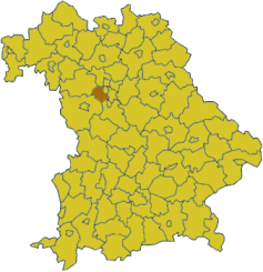
Fürth District is a district in Bavaria, Germany. It is bounded by (from the east and clockwise) the cities of Fürth and Nuremberg, and by the districts of Roth, Ansbach, Neustadt an der Aisch-Bad Windsheim and Erlangen-Höchstadt.
History[]
In the 13th and most of the 14th century the region was a regional centre of the Hohenzollern state. The Cadolzburg (a castle west of Nuremberg) was the seat of the local rulers.
The present district was established in 1972.
In 2003 the administrative seat was moved from Fürth to Zirndorf. Nonetheless, Fürth remains the official capital of the district.
Geography[]

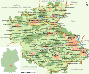
Map of the district Fürth
The district is occupied by the western Nuremberg metropolitan area.
Coat of arms[]

|
|
Towns and municipalities[]
| Towns | Municipalities |
|---|---|
|
|
References[]
- ^ "Fortschreibung des Bevölkerungsstandes" (in German). Bayerisches Landesamt für Statistik und Datenverarbeitung. 31 December 2010. https://www.statistikdaten.bayern.de/genesis/online?language=de&sequenz=tabelleErgebnis&selectionname=12411-009r&sachmerkmal=QUASTI&sachschluessel=SQUART04&startjahr=2010&endjahr=2010.
External links[]
Wikimedia Commons has media related to:
- Official Website (German)
- Official district Website (German)