| Main | Births etc |
|---|
| Haberfield Sydney, | |||||||||||||
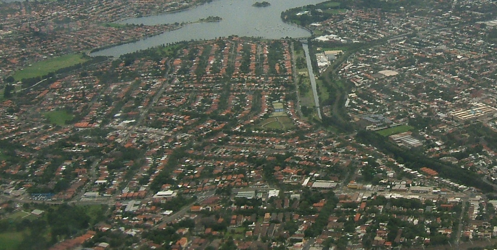 Aerial photograph of Haberfield | |||||||||||||
| Population: | 6,589 (2006 census) | ||||||||||||
| Postcode: | 2045 | ||||||||||||
| Location: | 9 km (6 mi) west of Sydney CBD | ||||||||||||
| LGA: | Municipality of Ashfield | ||||||||||||
| State District: | Balmain | ||||||||||||
| Federal Division: | Grayndler | ||||||||||||
| |||||||||||||
Haberfield is a suburb in the inner-west of Sydney, in the state of New South Wales, Australia. Haberfield is located 9 kilometres west of the Sydney central business district in the local government area of the Municipality of Ashfield.
Haberfield sits south of Iron Cove, which is part of Sydney Harbour. It is bounded to the east by the Hawthorne canal, to the northwest by the Iron Cove Creek canal and to the southwest by Parramatta Road. Its main road is Ramsay Street and the point of land that faces Iron Cove, Dobroyd Point, is a historical locality of Sydney. Haberfield was dubbed "the garden suburb" in the early 20th century and retains its well-kept parks, tree-lined streets and fine Federation-era houses with immaculate gardens. The entire suburb is heritage-listed.
History[]
Haberfield was named by early landholder Richard Stanton, after his wife's maiden name.[1]
Aboriginal culture[]
Haberfield was originally home to indigenous people from the Darug tribe known variously as the Wangals or Cadigals. These people were forced off their land not long after the British established a settlement at Sydney and started dividing the land up amongst their colonists. However, the area that is now Haberfield was one of the last areas in the inner-west to be developed so, in the late 19th century it again became a home to local kooris.[2]
European settlement[]
Nicholas Bayly, a soldier, received the first land grant in the area in 1803 but sold it two years later to Simeon Lord who called it Dobroyde Estate. Lord gave the land to his daughter Sarah Ann and her new husband David Ramsay as a wedding present in 1825 and it stayed in the hands of the Ramsay family until the end of the century. The Ramsays developed orchards in the area and built a number of fine houses for various members of the family including Yasmar (Ramsay spelt backwards) and St David's Presbyterian church. They also created four of the suburb's current streets: Ramsay Street, Dalhousie Street (named after the Ramsay's historic home in Scotland), Boomerang Street and Waratah Street.[3][4]
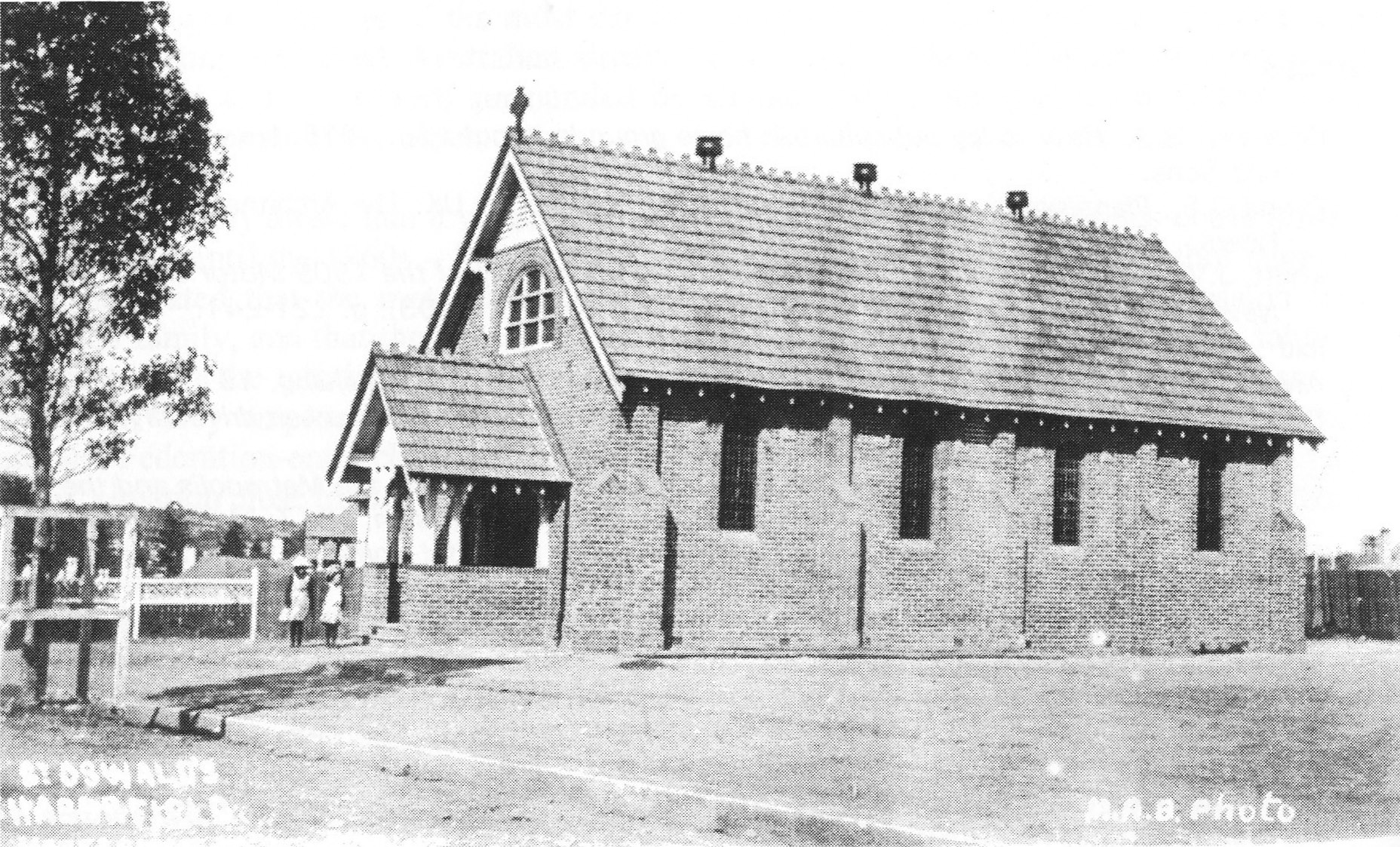

The nave of St Oswald's was built soon after subdivision of the suburb, and the Anglican parish divided from that of St John's Ashfield.
In 1901, landholder Richard Stanton bought 50 acres (200,000 m2) from two Ramsay children and subdivided the area to create a garden suburb. Sydney had recently suffered outbreaks of the bubonic plague in overcrowded parts of the inner city and the garden suburb movement was a response to that, encouraging fresh air. He also claimed the development to be "slumless, laneless and publess". The houses were designed by the architectural firm Spencer, Stansfield and Wormald. Stanton named the suburb 'Haberfield', after the English branch of his family. The fact that the development started in 1901 and a number of the early streets were named after prominent federal politicians has led to the suburb also being known as 'The Federation Suburb'.[5][6]
Heritage[]
The majority of houses in Haberfield are protected under a 'heritage order', which is the main reason why so many original Victorian and Federation houses still exist in the area. Renovations and additions to both houses and properties must follow strict guidelines ensuring they stay true to the era's style. Some examples of rules include: banning the addition of second storeys unless in the existing roof space, banning the demolishing of any protected houses, ensuring a 50:50 ratio of 'hard surface' to 'soft surface' on the property, ensuring house exteriors are painted in federation colours. Houses must also have a roof consisting of terracotta or slate tiles.
One notable landmark is Yasmar, at 185 Parramatta Road. Formerly known as Yasmar Hotel, this building was built circa 1870 of dressed stone, with a verandah and iron columns. It also features French windows and extensive cedar joinery, and is set in a lush garden. It is now part of Yasmar Juvenile Centre and is listed on the Register of the National Estate.[7]
Recent developments[]
There is currently a proposal by McDonald's to build a drive-thru outlet in Haberfield. This is being fiercely opposed by most local residents[8] who want to preserve the suburb's unique cultural heritage.[9] The development application was rejected by Ashfield Council,[10] however McDonald's appealed to the NSW Land and Environment Court and an interim judgment indicates that, subject to some changes to the plans, a 12 month trial will be granted for a 24/7 restaurant.[11]
Commercial area[]


Ramsay Street, Haberfield
Haberfield also has a strong Italian influence, which is most evident in the local shops along Ramsay Street, close to the intersection with Dalhousie Street. These include two hand made pasta shops, a traditional Italian bakery, traditional and contemporary Italian pastry shops and gelaterias, and Italian delicatessens and butchers, as well as many Italian cafes, coffee shops and restaurants. Many of the shops in Haberfield have received various awards for their quality. Haberfield Town Square is located on Ramsay Street, near the intersection of Gillies Avenue.
Schools[]
Haberfield has three primary schools but no high schools. Two of the schools are state run: Haberfield Public School in Bland Street and Dobroyd Point Public School in Waratah Street. The third is the St Joan of Arc Catholic School in Dalhousie Street opposite St Joan of Arc Church.
Transport[]


Aerial view of the Metropolitan Goods railway line, which is being converted to light rail
The current light rail service that runs from Central Station to Lilyfield is now being extended to Dulwich Hill, making use of a disused heavy rail freight line.[12][13] There will be three new stations serving Haberfield. These are – Hawthorne (on the eastern border of the suburb), Marion (near Marion St) and Taverners Hill (near Parramatta Road in the south-east corner of the suburb). The service will interchange with Lewisham railway station on the Inner West Line and Dulwich Hill railway station on the Bankstown Line.
Population[]
Demographics[]
According to the 2001 census, Haberfield had around 6,800 residents with a very strong Italian component, 30% speaking Italian at home. Apart from English speakers, all other languages recorded very low figures: Greek (2.2%), Spanish (1.0%), Cantonese (0.9%). The high number of Italians also contribute to a very high number of Roman Catholics (57%) in the suburb, more than twice the national average. Residents were slightly older (19% aged over 65) than the national average (13%). This in turn probably led to a higher proportion of people own their houses (57%) than the national average (40%).[14]
Notable residents[]
The following people were either born in, or lived in, Haberfield:
- Norman Allan (1901–1977), NSW police commissioner from 1962–1972
- Bronwyn Oliver (1959–2006), sculptor
Gallery[]
Churches[]
Haberfield has four historical churches in Dalhousie Street: St Oswalds Anglican Church, Saint Joan of Arc Catholic Church, St Davids Uniting Church, Haberfield Baptist Church.
")
")
")
Houses[]
Approximately 1500 houses were constructed in this and adjoining areas to designs by archiects J Spencer Stansfeld and D Wormald, of Federation style or Bungalow style. Haberfield espoused the philosophy of the Garden Suburb with its gardens containing distinctive planting, fences, gates and curving tiled paths. Houses in Haberfield were typically 'detached' double-brick dwellings situated on their own block of land measuring 50' x 150' (15 m x 45 m). No two houses were alike, although there were many common themes throughout the suburb. The roofs were either slate or Marseilles tile. All had front verandahs. Decorative features typically used in this area include leadlight windows depicting Australian flora and fauna, Art Nouveau timber detailing and tuckpointed brickwork.[15]
Houses listed under the NSW Heritage Act:
- Bunyas, 5 Rogers Avenue, Haberfield
- Derrylyn, 16 Deakin Avenue, Haberfield
- Yasmar, 185 Parramatta Road, Haberfield
")
")
")
")
")
")
")
")
")
Parks[]
Several parks lie within the suburb of Haberfield such as; Algie Park, Robson Park, Reg Cody Reserve, Hawthorne Canal and Wadim 'Bill' Jegorow Reserve
")
")
")
")
References[]
- ^ The Book of Sydney Suburbs, Compiled by Frances Pollon, Angus & Robertson Publishers, 1990, Published in Australia ISBN 0-207-14495-8
- ^ Coupe, S&R: Speed the Plough, page 9-19,128. Ashfield Municipal Council, 1988 ISBN 0-9595234-1-3
- ^ Coupe, S&R: Speed the Plough, page 26,36–37. Ashfield Municipal Council, 1988 ISBN 0-9595234-1-3
- ^ "Origin of Haberfield Street and Place names". The Haberfield Association. http://linus.socs.uts.edu.au/~colville/habas/habstr.html. Retrieved 2007-05-22.
- ^ Coupe, S&R: Speed the Plough, page 151-170. Ashfield Municipal Council, 1988 ISBN 0-9595234-1-3
- ^ "Haberfield Development Control Plan". Ashfield Municipal Council. http://www.ashfield.nsw.gov.au/planning/dcps/haberfield-1995.pdf. Retrieved 2007-05-22.
- ^ The Heritage of Australia, Macmillan Company, 1981, p.2/11
- ^ http://www.nomaccashaberfield.org/
- ^ http://inner-west-courier.whereilive.com.au/news/story/residents-oppose-haberfield-maccas1/
- ^ http://inner-west-courier.whereilive.com.au/news/story/haberfield-mcdonald-s-proposal-rejected/
- ^ http://inner-west-courier.whereilive.com.au/news/story/haberfield-maccas/
- ^ http://www.transport.nsw.gov.au/sites/default/file/rail/Sydney-Light-Rail-Inner-West-Extension-Draft-Report.pdf
- ^ http://www.transport.nsw.gov.au/sites/default/file/rail/Sydney-Light-Rail-Inner-West-Extension-Draft-Appendices.pdf
- ^ Australian Bureau of Statistics (19 November 2002). "Community Profile Series : Haberfield (State Suburb)". 2001 Census of Population and Housing. http://www.censusdata.abs.gov.au/ABSNavigation/prenav/ProductSelect?newproducttype=Community+Profiles&collection=Census&period=2001&areacode=SSC12066&breadcrumb=LP¤taction=201&action=401. Retrieved 2007-06-30.
- ^ http://www.heritage.nsw.gov.au
- St Joan of Arc Parish Bulletin
External links[]
- The Haberfield Association
- The Haberfield Heritage
- Haberfield Heritage's photostream
- Haberfield, the Garden Suburb
| ||||||||
| |||||||||||||||||||||||||||||
| This page uses content from the English language Wikipedia. The original content was at Haberfield, New South Wales. The list of authors can be seen in the page history. As with this Familypedia wiki, the content of Wikipedia is available under the Creative Commons License. |