| Main | Births etc |
|---|
| Hurstville Sydney, | |||||||||||||
 Hurstville library | |||||||||||||
| Population: | 26,040[1] | ||||||||||||
| Established: | 1887 | ||||||||||||
| Postcode: | 2220 | ||||||||||||
| Area: | 4.2 km² (1.6 sq mi) | ||||||||||||
| Location: | 16 km (10 mi) south of Sydney CBD | ||||||||||||
| LGA: | Hurstville, Kogarah | ||||||||||||
| State District: | Kogarah, Oatley | ||||||||||||
| Federal Division: | Banks | ||||||||||||
| |||||||||||||
Location map of Hurstville based on NASA satellite images

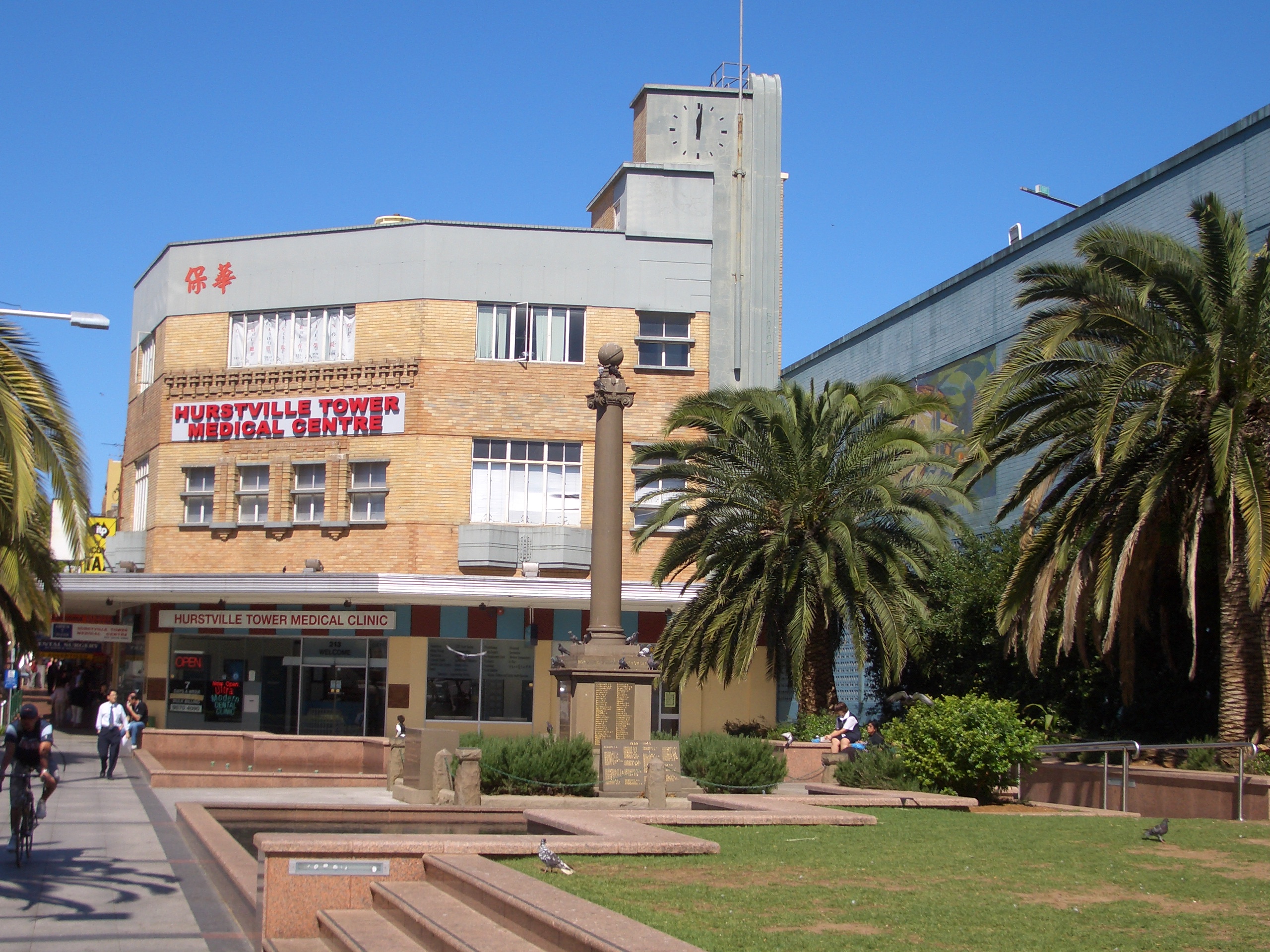
Memorial Square, Forest Road, Hurstville


Forest Road, Hurstville
Hurstville is a suburb in southern Sydney, New South Wales, Australia. It is 16 kilometres south of the Sydney central business district and is part of the St George area. Hurstville is the administrative centre of the local government area of the City of Hurstville.
Hurstville has become a central business district for the southern suburbs of Sydney. It is a large, multiethnic suburb with a multitude of commercial buildings and high-rise residential buildings dominating the skyline. Hurstville's residential developments are a mixture of low-density housing, medium-density flats, and high-density apartment buildings. As a commercial centre, it features branches of many retail shops as well as numerous banks and other financial institutions.
History[]
The name "Hurstville" is derived from the English "hurst", meaning "a wooded eminence", and "ville", "town".[2]
Aboriginal culture[]
Although it is unknown when they first settled in the Hurstville area, the first inhabitants were Australian Aborigines. At the time of the arrival of the First Fleet, the Aborigines residing in the area were of the Eora tribe, whose numbers spanned along the Georges River, from Botany Bay to present-day Liverpool.
European settlement[]
The land of the Hurstville region was granted by the government of the new colony of New South Wales to two men; Captain John Townson and his brother Robert Townson in 1808. Captain John Townson was granted 1950 acres (7.9 km²) of land which is now occupied by the suburb of Hurstville and part of Bexley. Robert Townson was granted the land which is now occupied by Penshurst, Mortdale and parts of Peakhurst. In the same year, in the area now known as Riverwood land grants were made to Jane Trotter, Mary Shepley, Charles Doudall, and James Ryan. Later in 1816 another land grant in the same area was given to Mary Redman.
In 1809, Captain John Townson was granted an additional 250 acres (1 km²) in the area now occupied by Kingsgrove and Beverly Hills. The Townson brothers were not happy with the land that they were given because it was not suitable for the farming of sheep for wool and it is likely that the brothers never occupied their land. In 1812, a wealthy merchant named Simeon Lord bought the land of Captain John Townson and named it Lord's Forest. When Lord, died the land became the property of John Rose Holden and James Holt of the Bank of NSW.
Development[]
A dam with a roadway on top was constructed on the Cooks River at Tempe in 1839. In 1843, the road that was to become known as Forest Road was extended from the dam to a hand-winched punt in Lugarno. On the other side of the river, the road continued all the way to Wollongong; however, it was only suitable for travellers on horseback. The new road opened up the Hurstville region and created a settlement at Bottle Forest, now known as Heathcote.
In 1850, the Lord Forest estate was purchased by Michael Gannon (1800–61), who subdivided it into small farms along what is now Croydon Road and three larger farms that were purchased by Dent, Peake, and Ibbotson. The area became known as Gannon's Forest. The land originally granted to Robert Townson was purchased by John Connell in 1830 and, following his death in 1849, the estate was inherited by his grandsons, Elias Pearson Laycock and John Connell Laycock.
The Gannon's Forest post office opened in 1881. The local school was named "Hurstville" by School Inspector MacIntyre when it was established in 1876. When the railway station opened on 15 October 1884, it took the name Hurstville, from the school. Hurstville municipality was incorporated in 1887 and, in 1988, Hurstville was declared a city. The Centenary Bakery on Forest Road is a historic building that has been preserved and once housed a museum. The St George Regional Museum is now located in another historic building in MacMahon Street.
The Hurstville train crash on 3 August 1920 resulted in five people killed and fifty injured. It involved the collision of two steam trains, one arriving from Central plunged into the back of the other bound that was stationary at Hurstville railway station, bound for Sutherland.[3]


Hurstville Westfield
Commercial area[]
Hurstville's commercial area is centred around the main street, Forest Road, on the northern side of Hurstville Railway station. The commercial developments also extend to surrounding streets concentrated from Queens Road to The Avenue and on the southern side of Hurstville Railway station, around Ormonde Parade. The commercial developments extend further along Forest Road, west towards Penshurst and east towards Bexley.
Westfield Hurstville is the largest shopping centre in the St George area. It is built over three blocks and stretches from Forest Road over Crofts Street, Park Avenue to The Avenue. Hurstville Central (formerly the 'Hurstville SupaCentre') is a small shopping centre on top of Hurstville Railway station, which has recently undergone total refurbishment. It links Forest Road with Ormonde Parade.
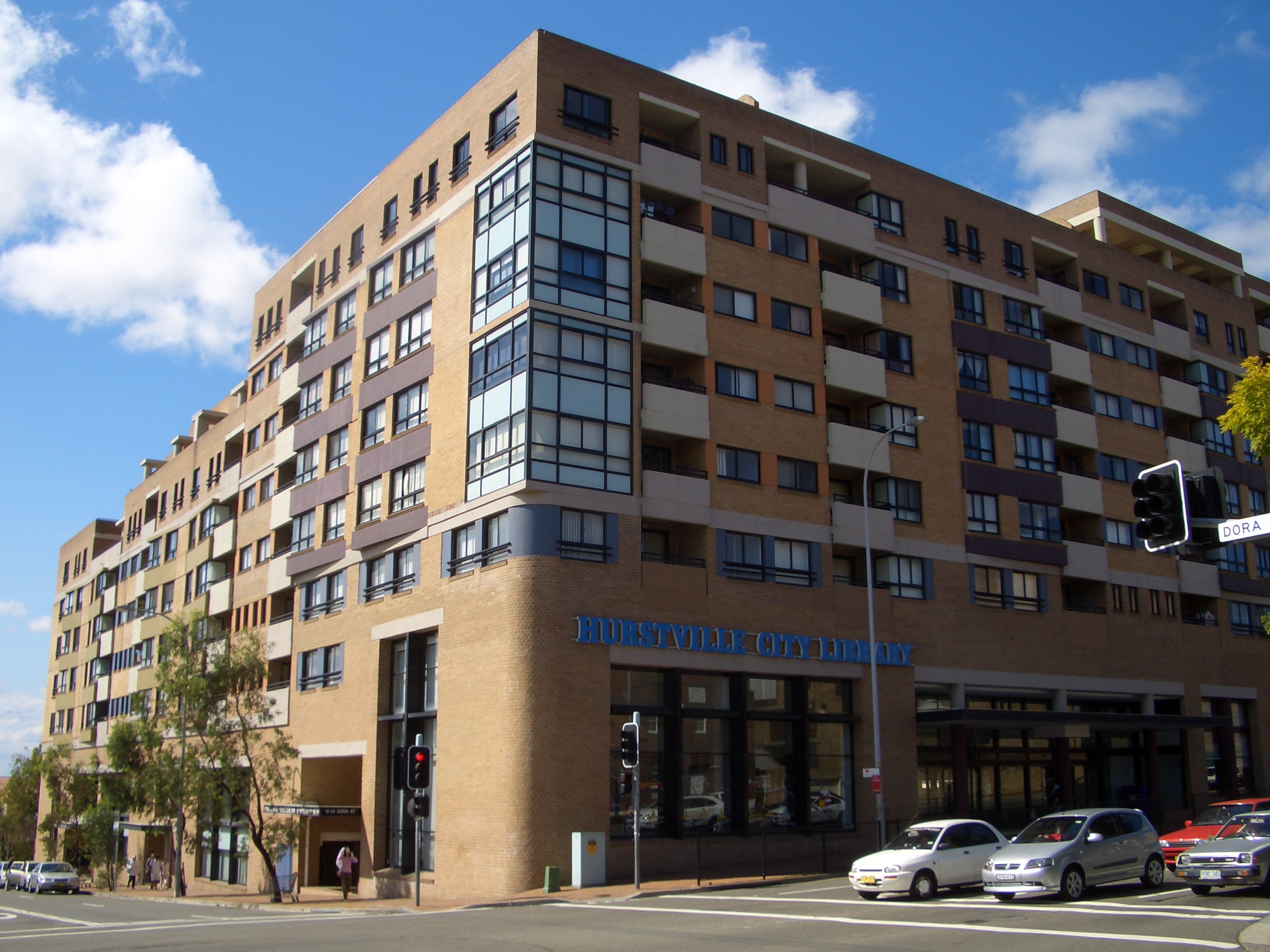
The administrative offices of the City of Hurstville are located in the Hurstville Civic Centre in MacMahon Street. This street also features a number of historic buildings such as the Friendly Pharmacy, old Fire Station, Ritz Hotel and the St George Regional Museum, which houses the cake decorating collection formerly held at the Australian Cakes and Sugar Art Museum. Hurstville City Library is located nearby on Queens Road.

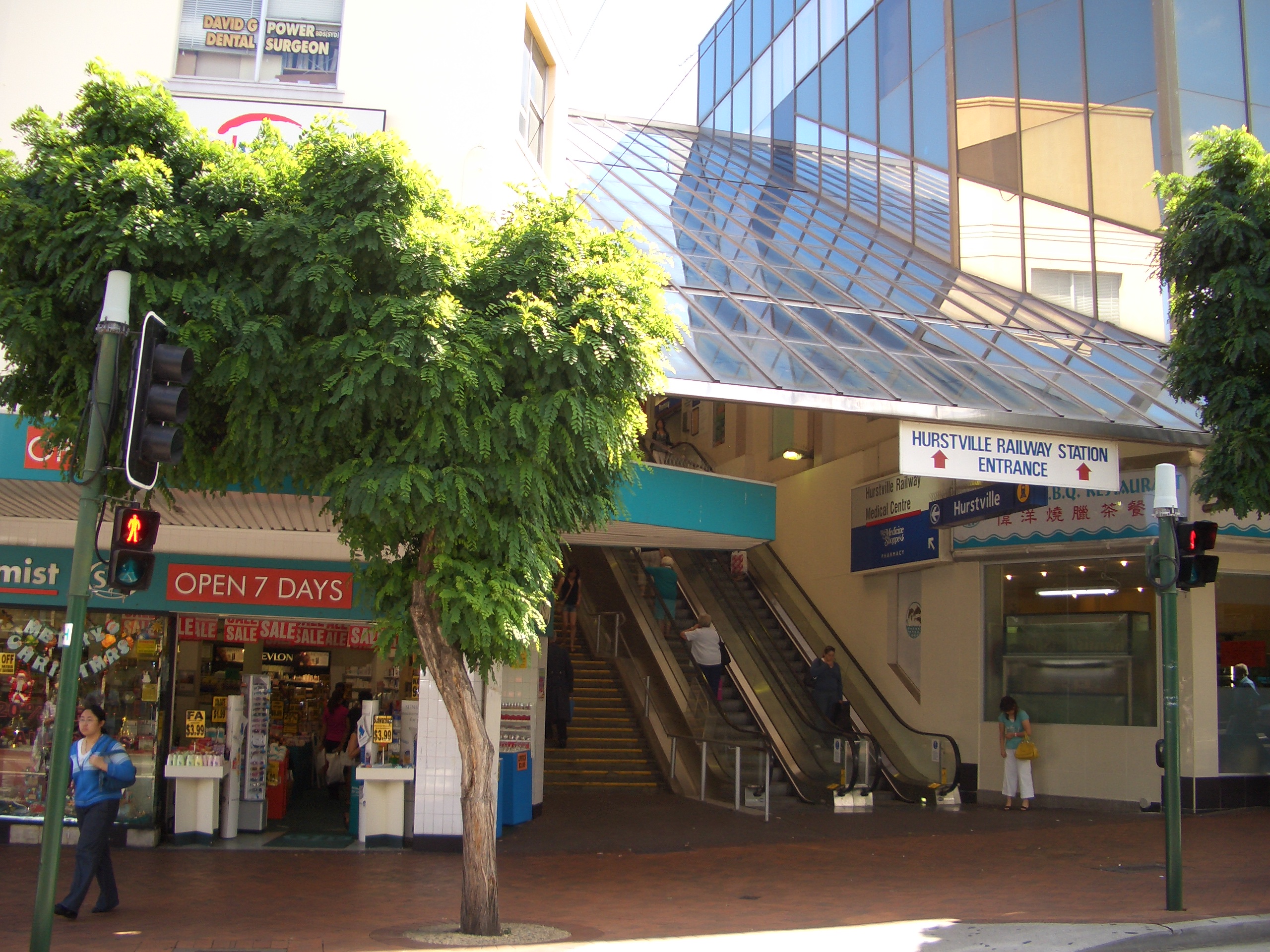
Hurstville railway station entrance, Forest Road
Arts and culture[]
The St Clair Recording Studio operated for about a year from December 1965 to December 1966 and recorded the Bee Gees among other musicians.[4] AC/DC played at the Hurstville Civic Centre in 1977.
A karaoke place opened in 2011 near the Meridian Hotel, the first ever one in Hurstville.
Transport[]
Hurstville railway station is a major station on the Illawarra line of the City Rail network. All suburban and most interurban trains stop at Hurstville. Hurstville is 20 minutes from Sydney Central railway station on the express service. Hurstville is a major bus interchange with bus services departing from Forest Road and Ormonde Parade.
Churches[]
- St Georges Anglican Church, St Michaels Catholic Church, Hurstville Presbyterian Church, Hurstville Church of Christ, Hurstville Uniting Church, Hurstville Seventh-day Adventist Church, Hurstville Assemblies of God, Salvation Army, Church of the Living God.
")
")
")
")
")
")
")
")
Schools[]
- Hurstville Adventist School, Hurstville Boys High School, Hurstville Public School, Danebank Anglican Girls School, Bethany College, Beverly Hills Public School and St George Christian School. Sydney Technical High School, Bethany College and St. Mary's Star of the Sea are located just over the border in Bexley.
")
Landmarks[]
- Hurstville Civic Centre, Hurstville Entertainment Centre, Hurstville City Library, St George Regional Museum, Park Plaza Apartments
")
")
")
")
")
")
")
")
")
")
")
")
Parks[]
- Kempt Field, Woodville Park, Hurstville Park, Thorpe Park, Doyle Gardens.
")
")
")
")
Population[]


Apartments in Forest Road
Demographics[]
The first European settlers in the area were mostly of British and Irish ancestry. From the late 1960s, Hurstville, like many surrounding areas, became home to migrants from all around the world. The first wave of migrants included Greeks and Italians who began moving south from Sydney's inner-city suburbs. They were followed by more European migrants, including many from the former Yugoslavia, such as Bosnians and Macedonians.
From the 1990s, the Chinese community within Hurstville has grown considerably. Much of this was related to significant migration from Hong Kong during the 1990s and migration from Mainland China during the 2000s. Many local businesses are operated by people of Chinese background, the interests of which are advanced by the St. George Asian Business Association. Hurstville is a hub for Asian groceries, food and services.
According to the 2011 Australian Bureau of Statistics Census of Population, there were 26,040 residents in Hurstville. 68.4% stated they were born overseas, with the top countries of birth being China (34.2%), Hong Kong (4.6%), and Nepal (2.7%). English was stated as the only language spoken at home by 21.8% of residents and the most common other languages spoken were Mandarin (26.7%), Cantonese (20.4%), Greek (3.7%), and Arabic (3.6%). The most common responses for religious affiliation were no religion (35.6%), Catholic (15.0%), Buddhism (10.0%) and Orthodox (7.5%). The largest ancestry group was Chinese, reported by 47.5% of respondents, followed by English (7.6%), Australian (6.8%), and other or undeclared ancestry (38.1%).[1]
Notable residents[]
- Ronald Ernest Aitchison - Physicist
- Arthur Samuel Allen (1894-1959) - army officer and accountant [5]
- Ezekiel Alexander Baker (1823-1912) - politician [6]
- Sir Jack Brabham - Three-time Formula One World Champion motor racer
- Richard Stanley (Dick) Charles (1901-1974) - spearfisherman and motor trader [7]
- Sir John Grenfell (Jack) Crawford (1910-1984) - economist, public servant and academic administrator [8]
- Thomas Vincent Dunlea (1894-1970) - Catholic priest [9]
- Ambrose George Enticknap (1894-1976) - orchardist and politician [10]
- Stella Maria Sarah Miles Franklin - Writer
- Neville Hayes - Swimmer
- Thomas John Ley (1880-1947) - politician and murderer [11]
- Jack Lindwall - Rugby league player for St George
- Ray Lindwall - Australian Test cricketer, also played rugby league for St George; younger brother of Jack
- Craig Nicholls - Musician
- Eris Michael O'Brien (1895-1974) - Catholic archbishop and Australian historian [12]
- John Radecki (1865-1955) - stained-glass designer [13]
- Edward Henry Rembert (1902-1966) - architect [14]
- Gordon Stanley Reid (1923-1989) - parliamentary official, political scientist and governor [15]
- Thomas Wright (1902-1981) - sheet-metal worker and trade union official [16]
References[]
- ^ a b Australian Bureau of Statistics (31 October 2012). "Hurstville (State Suburb)". 2011 Census QuickStats. http://www.censusdata.abs.gov.au/census_services/getproduct/census/2011/quickstat/SSC11148?opendocument&navpos=220. Retrieved 12 May 2013.
- ^ City of Hurstville - History of Hurstville
- ^ Pollon, F. (1990.) The Book of Sydney Suburbs, Angus & Robertson Publishers, Sydney, p. 130.
- ^ Hurstville City Council - The St Clair Recording Studio
- ^ Australian Dictionary of Biography
- ^ Australian Dictionary of Biography
- ^ Australian Dictionary of Biography
- ^ Australian Dictionary of Biography
- ^ Australian Dictionary of Biography
- ^ Australian Dictionary of Biography
- ^ Australian Dictionary of Biography
- ^ Australian Dictionary of Biography
- ^ Australian Dictionary of Biography
- ^ Australian Dictionary of Biography
- ^ Australian Dictionary of Biography
- ^ Australian Dictionary of Biography
External links[]
| ||||||||
| This page uses content from the English language Wikipedia. The original content was at Hurstville, New South Wales. The list of authors can be seen in the page history. As with this Familypedia wiki, the content of Wikipedia is available under the Creative Commons License. |