| Paddington Sydney, | |||||||||||||
 Paddington Town Hall | |||||||||||||
| Population: | 11,660[1] | ||||||||||||
| Postcode: | 2021 | ||||||||||||
| Area: | 1.5 km² (0.6 sq mi) | ||||||||||||
| Property Value: | AUD $1,220,000 (2007) | ||||||||||||
| Location: | 3 km (2 mi) east of Sydney CBD | ||||||||||||
| LGA: |
| ||||||||||||
| State District: | Sydney | ||||||||||||
| Federal Division: | Wentworth | ||||||||||||
| |||||||||||||
Paddington is an inner-city, eastern suburb of Sydney, in the state of New South Wales, Australia. Paddington is located 3 kilometres east of the Sydney central business district and lies across the local government areas of the City of Sydney and the Municipality of Woollahra.[2] Paddington is colloquially known as Paddo.
Paddington is located primarily on the northern slope down from a ridgeline at the crest of which runs Oxford Street. Paddington is bordered to the west by Darlinghurst, to the east by Centennial Park and Woollahra, to the north by Edgecliff and Kings Cross and to the south by Moore Park.
Commercial area[]
A bustling, cosmopolitan suburb of the Eastern Suburbs, straddling the arterial route of Oxford Street, Sydney, this is one of the most historically rich, culturally vibrant and recognisable districts of Sydney. Paddington is famous for its plethora of boutique and chain fashion stores as well as many cafés and restaurants. Five Ways is a multiple intersection located in the backstreets of Paddington which is popular with local residents and tourists because of its range of cafés and bars.
History[]
Aboriginal culture[]
The suburb of Paddington is considered to be part of the land associated with the stories and rituals of the Cadigal people. These people belonged to the Dharug (or Eora) language group, and were also the traditional owners of what is now the Sydney central business district. It is known that the ridge on which Oxford Street was built was also a walking track used by Aboriginal people. Much of the Aboriginal population of Sydney was decimated by the smallpox outbreak of 1789, only one year after the First Fleet arrived in Sydney (City of Sydney, 2005). Settlers' records from the time indicate that only three members of the Cadigal tribe were left after this outbreak. However, some anthropologists maintain that the tribe dispersed into other areas of the shared Eora language group. The history of the Aboriginal population in the Paddington area is hard to find, but it is known that, at the time when Robert Cooper began to build his first house there, approximately 200 Koori people were living in Woolloomooloo in huts which Governor Macquarie had built for them.[3]
Paddington has never been a suburb with a dense indigenous population. In the 1930s, when parts of Sydney such as Redfern and Glebe became hubs for Aborigines entering the labour force, Paddington continued to be a white working-class suburb. Applying the now-abolished principle of terra nullius, British colonisers arrived in Sydney and declared the land to be empty, claiming it as their own. Recent history has shown us that this was certainly not the case, and events such as the Mabo Decision, the advent of native title and the Wik decision have helped to give back some of the land that Aboriginal people were dispossessed of. However, little of this has been in the Sydney area. Currently in Paddington, only 41 people, or 0.3% of the local population, are from Aboriginal (or Torres Strait Islander) descent. The land is so heavily excavated and densely built-upon that there is no land available for claim, and with the fragmentation and distancing of the Cadigal people from their land, it would be almost impossible to prove a consistent community bond throughout the years of colonisation.[4]
European settlement[]
In the early 1820s, ex-convict entrepreneur and gin distiller Robert Cooper set out to build a grand Georgian estate at the top of Paddington's ridgeline, affording excellent views. He named the area Paddington after a London borough. He called the estate Juniper Hall, which remains Paddington's oldest home. The district's first cottages were built around Victoria Barracks, formerly a major army base. In the latter part of the 19th century, many terrace houses were constructed to house the city's burgeoning working population and an emerging middle class. Over time, these houses filled up almost every parcel of land, causing the suburb to become overpopulated. The unfashionable nature of the suburb continued until the mid-1960s, when gentrification took hold. At this time the area developed a bohemian aspect with a large arts community attracting creative and alternative residents. The suburb is now an example of uncoordinated urban renewal and restoration, where desirable location and heritage charm have contributed to flourishing real-estate values. Old boot-repair and linen shops have given way to designer fashion outlets and gourmet food. Since 1973, the suburb has also featured a bohemian market, conducted each Saturday in the grounds of the Paddington Uniting Church and the playground of the adjacent Paddington Public School.
")
")
")
Landmarks[]
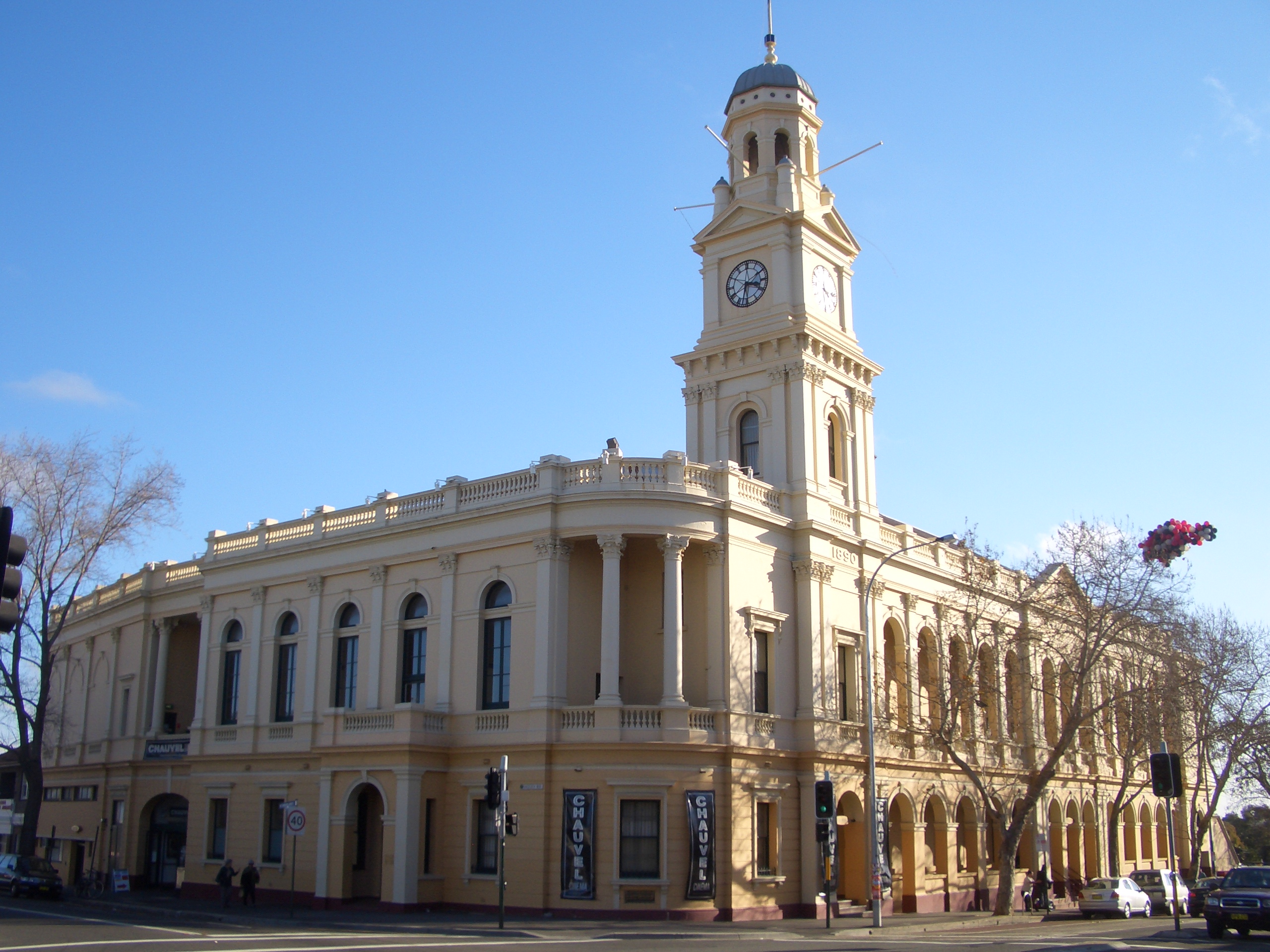
Paddington Town Hall[]
Paddington Town Hall was built in the late 1800s at a cost of £15,000. It opened in 1891 and remains a distinctive example of European architecture in Sydney. Its clock tower stands 32 metres high and, sitting on the ridge of Oxford Street, dominates the Paddington skyline. The hall now houses radio studios, a cinema and a local library, and is a venue for private functions. Paddington Town Hall was the site of a meeting of Rugby League players in 1907, at which the Eastern Suburbs Roosters Rugby League club, now the Sydney Roosters, was officially formed.
Juniper Hall[]
Juniper Hall was built by Robert Cooper, an ex-convict, in the 1820s and is the oldest house in Paddington. It is a large, dominating structure which lies diagonally opposite the Paddington Town Hall. It has undergone significant restoration and was owned for some time by the National Trust as a Heritage House. Today it is leased privately and is not open to the public, but can still be seen from Oxford Street.
")
")
")
")
Victoria Barracks[]
Victoria Barracks is an Australian Army base, set back from Oxford Street south of the Paddington Town Hall. It is constructed of Hawkesbury sandstone, which was sourced from the area and beyond, and was built by convict labour over seven years, opening in 1848. For much of the early part of Australia's history, and continuing from Federation in 1901, the barracks were the premier site for military training in Australia. It is currently home to Headquarters Land Command and Headquarters Training Command. It is open every Sunday from 10am until 3pm.[5]
Oxford Street[]
Oxford Street was originally used as an Aboriginal walking track, then as a faster route to South Head, and has had various incarnations as a shopping strip. Once serving the needs of the local residents, Paddington's Oxford Street has changed to now serve a middle- and upper-class population, as well as being a focal point for the tourist industry. Many visitors to Paddington come solely for the experience of shopping on Oxford Street.
Heritage buildings[]
The following buildings are on the Register of the National Estate:[6]
- Victoria Barracks, Oxford Street
- Houses, 4-30 Moore Park Road
- Paddington Town Hall, Oxford Street
- Paddington Court House, Jersey Road
- Paddington Public School, Oxford Street
- Uniting Church and Parsonage, Oxford Street
- House, 30 Gordon Street
- St Matthias Church Group, Oxford Street
- Former Rectory, 495 Oxford Street
- St Matthias Church Hall, Oxford Street
- Houses, 3-9 Church Place
- Royal Hotel, Glenmore Road
Houses[]
Paddington is known for its Victorian terrace houses which, having been slums for much of the post-World War II period, were later gentrified and are highly sought after. The suburb is characterised by an array of interconnecting streets and laneways, some too narrow for many of today's cars. These streets contrast to some other much wider avenues, such as Paddington Street or Windsor Street.
")
")
")
")
Transport[]
The Eastern Distributor and Cross City Tunnel transit Paddington below ground, both being easily accessible from the suburb.
Paddington is serviced by public transport, primarily buses. Oxford Street is the hub, with bus routes through Darlinghurst towards Circular Quay and Central Station in one direction, and towards Bronte, Bondi, or Bondi Junction in another.
Culture[]
Paddington Markets[]
Paddington has a popular open-air market held every Saturday in the grounds of the heritage-listed sandstone Paddington Uniting Church on Oxford Street. There are 250 stalls selling Australian contemporary art, craft and fashion, directly by the artists and craft makers.
Sydney Football Stadium[]
The Football Stadium on Moore Park Road on Paddington's southern border. It is the home ground of the Sydney Roosters, NSW Waratahs and Sydney FC, and can be seen best from the top of Oatley Road, just outside the Paddington Town Hall.
Demographics[]
The population of Paddington, at the 2001 census, was 11,817 people (ABS, 2001). The area has a high level of foreign ancestry, with only 25% of people in the 2001 census identifying that their parents were born in Australia. In contrast, 67% had parents who were born in North-West European nations, such as England and Ireland. 70% of people in the suburb live in typical Victorian terrace houses, with the majority of the rest living in apartments. The suburb is a high-wealth area, with 40% of households indicating they earned more than A$2000 per week.
References[]
- ^ Australian Bureau of Statistics (25 October 2007). "Paddington (State Suburb)". 2006 Census QuickStats. http://www.censusdata.abs.gov.au/ABSNavigation/prenav/LocationSearch?collection=Census&period=2006&areacode=SSC11769&producttype=QuickStats&breadcrumb=PL&action=401. Retrieved 2009-09-04.
- ^ Gregory's Street Directory, Gregory's Publishing Company, 2007
- ^ Barani, City of Sydney (2005). Aboriginal People and Place
- ^ The Book of Sydney Suburbs, compiled by Frances Pollen, Angus & Robertson Publishers, 1990, Sydney. ISBN 0-207-14495-8. p.195
- ^ Australian War Memorial (2005). Australian Military Units: Victoria Barracks (Sydney)
- ^ The Heritage of Australia, Macmillan Company, 1981, pp.2/84-85
See also[]
External links[]
- Paddington, New South Wales is at coordinates Coordinates:
| ||||||||
| |||||||||||
| This page uses content from the English language Wikipedia. The original content was at Paddington, New South Wales. The list of authors can be seen in the page history. As with this Familypedia wiki, the content of Wikipedia is available under the Creative Commons License. |