| ||||||||||||||
| Allen County, Indiana | |
 Allen County Courthouse in Fort Wayne
| |
 Location in the state of Indiana | |
 Indiana's location in the U.S. | |
| Founded | 1 April 1824 |
|---|---|
| Seat | Fort Wayne |
| Area - Total - Land - Water |
660.10 sq mi (1,710 km²) 657.25 sq mi (1,702 km²) 2.85 sq mi (7 km²), 0.43% |
| Population - (2020) - Density |
385,410 541/sq mi (208.73/km²) |
| Congressional districts | 3rd, 6th |
| Website | www.co.allen.in.us |
Footnotes:
| |
Allen County is the largest county (by area) in the state of Indiana, United States. As of the 2020 Census, the population was 385,410. The county seat and largest city is Fort Wayne[1]. Allen County is within a 250-mile (400 km) radius of 17 percent of the total United States population and within a day's drive of half of the nation's population,[2] along with sitting nearly equidistant from Chicago, Columbus, Detroit, and Indianapolis.[3] Allen County's economy is based on manufacturing, education, health care, and agriculture.[4]
History[]
Allen County was created on December 17, 1823, out of Delaware and Randolph counties and formed April 1, 1824. The county is named for Colonel John Allen, an attorney and Kentucky state senator who was killed in the War of 1812. Fort Wayne, founded at the Maumee River, St. Joseph River, and St. Marys River, was chosen as the county seat in May 1824.
Government[]
The county government is a constitutional body, and is granted specific powers by the Constitution of Indiana, and by the Indiana Code.
County Council: The seven member county council has the ultimate decision-making power regarding fiscal affairs of the county government and controls all the spending and revenue collection in the county. Four representatives are elected from county districts, and three members are elected at large. The council members serve four year terms. They are responsible for setting salaries, the annual budget, and special spending. The council also has limited authority to impose local taxes, in the form of an income and property tax that is subject to state level approval, excise taxes, and service taxes.[5][6]
Board of Commissioners: The executive and administrative body of the county is made of a three member board of commissioners. The commissioners are elected county-wide, in staggered terms, and each serves a four-year term. One of the commissioners serves as president of the board. The commissioners are charged with enacting and executing legislation, the collection of revenue, and managing the day-to-day functions of the county government.[5][6]
Court: The county maintains a Circuit Court and a Superior Court.[7] These are the trial courts of general jurisdiction. Allen Superior Court hears the vast majority of cases, and has several divisions with multiple courtrooms.
County Officials: The county has several other elected offices, including sheriff, coroner, auditor, treasurer, recorder, surveyor, and circuit court clerk. Each of these elected officers serves a term of four years and oversees a different part of county government. Members elected to county government positions are required to declare a party affiliation and to be residents of the county.[6]
The county government operates the jail, maintains rural roads, operates the major local courts, keeps files of deeds and mortgages, maintains vital records, administers public health regulations, and participates with the state in the provision of welfare and other social services.
Allen County is part of Indiana's 3rd congressional district and is represented by Jim Banks in the United States Congress. It is part of Indiana Senate districts 14, 15, 16, 17 and 19;[8] and Indiana House of Representatives districts 50, 79, 80, 81, 82, 83, 84 and 85.[9]
Over the last 100 years, Allen County has been a Republican stronghold in presidential elections. The Democratic national landslides of Franklin D. Roosevelt in 1932 & 1936 as well as Lyndon B. Johnson in 1964 constitute the only occasions since then that a Republican presidential candidate failed to carry the county. As of 2020, Joe Biden was the highest vote earner for a Democratic candidate in the history of the county with 73,189 votes. Donald Trump achieved the same feat for his party, with 92,083 votes. However, the presence of a major urban center makes the county one of the Democrats' strongest counties in Indiana. In 2008, Barack Obama became the first Democratic President after Johnson to receive 40% of the county's vote. While he lost the county by 4 points, the closest that a Democrat has come to carrying the county, he won the city of Fort Wayne itself by six points.[10] However, in 2016, Donald Trump won the county by 19 points and city by 6, but in 2020, while Joe Biden lost the county by 11 points, he recaptured Fort Wayne.[11][12] The last Democratic Governor to win the county was Frank O'Bannon in 2000 and the last Senator was Evan Bayh during his 2004 landslide.[13][14]
Following the 1930 Census, Fort Wayne was drawn into Indiana's 4th congressional district until being redrawn into the current 3rd district following 2000 Census. Since 1932, Fort Wayne has been represented in the Congress by Democrats for 20 years out of 90: James Indus Farley from 1933 to 1939, Edward H. Kruse for a single term in 1949-1951, J. Edward Roush from 1971 to 1977 and Jill Long Thompson from 1989 to 1995.[15]
| Year | Republican | Democratic | Third party | |||
|---|---|---|---|---|---|---|
| No. | % | No. | % | No. | % | |
| 2020 | 92,083 | 54.31% | 73,189 | 43.16% | 4,288 | 2.53% |
| 2016 | 83,930 | 56.47% | 55,382 | 37.26% | 9,320 | 6.27% |
| 2012 | 84,613 | 57.46% | 60,036 | 40.77% | 2,597 | 1.76% |
| 2008 | 77,793 | 51.67% | 71,263 | 47.34% | 1,491 | 0.99% |
| 2004 | 82,013 | 63.28% | 46,710 | 36.04% | 886 | 0.68% |
| 2000 | 70,426 | 61.60% | 41,636 | 36.42% | 2,258 | 1.98% |
| 1996 | 59,255 | 53.55% | 41,450 | 37.46% | 9,940 | 8.98% |
| 1992 | 55,003 | 45.24% | 39,629 | 32.60% | 26,945 | 22.16% |
| 1988 | 74,638 | 64.94% | 39,238 | 34.14% | 1,059 | 0.92% |
| 1984 | 75,505 | 65.67% | 38,462 | 33.45% | 1,008 | 0.88% |
| 1980 | 68,524 | 57.63% | 37,765 | 31.76% | 12,609 | 10.60% |
| 1976 | 71,321 | 60.56% | 44,744 | 37.99% | 1,704 | 1.45% |
| 1972 | 76,924 | 66.20% | 38,621 | 33.24% | 654 | 0.56% |
| 1968 | 59,211 | 54.34% | 40,411 | 37.09% | 9,332 | 8.57% |
| 1964 | 49,284 | 49.11% | 50,706 | 50.53% | 363 | 0.36% |
| 1960 | 60,103 | 60.33% | 39,235 | 39.39% | 280 | 0.28% |
| 1956 | 58,210 | 69.43% | 25,444 | 30.35% | 190 | 0.23% |
| 1952 | 54,877 | 66.16% | 27,506 | 33.16% | 558 | 0.67% |
| 1948 | 37,494 | 54.00% | 31,239 | 44.99% | 703 | 1.01% |
| 1944 | 41,907 | 57.64% | 30,445 | 41.87% | 357 | 0.49% |
| 1940 | 40,430 | 57.18% | 29,967 | 42.38% | 312 | 0.44% |
| 1936 | 24,765 | 37.44% | 39,151 | 59.19% | 2,230 | 3.37% |
| 1932 | 27,065 | 40.66% | 38,447 | 57.76% | 1,050 | 1.58% |
| 1928 | 34,234 | 56.38% | 26,292 | 43.30% | 194 | 0.32% |
| 1924 | 25,207 | 54.12% | 17,244 | 37.03% | 4,122 | 8.85% |
| 1920 | 24,208 | 57.40% | 13,804 | 32.73% | 4,165 | 9.88% |
| 1916 | 10,169 | 46.03% | 9,470 | 42.87% | 2,451 | 11.10% |
| 1912 | 3,423 | 18.43% | 8,659 | 46.63% | 6,487 | 34.93% |
| 1908 | 9,468 | 42.06% | 12,145 | 53.95% | 900 | 4.00% |
| 1904 | 10,261 | 50.38% | 9,250 | 45.42% | 856 | 4.20% |
| 1900 | 8,250 | 42.73% | 10,764 | 55.75% | 295 | 1.53% |
| 1896 | 8,467 | 45.44% | 9,909 | 53.18% | 256 | 1.37% |
| 1892 | 5,486 | 34.03% | 10,010 | 62.09% | 625 | 3.88% |
| 1888 | 5,455 | 35.41% | 9,692 | 62.92% | 257 | 1.67% |
Elected officials[]
- Board of Commissioners[17]
- Linda K. Bloom
- Therese M. Brown
- F. Nelson Peters


Allen County Courthouse.
- Prosecuting Attorney, Karen E. Richards
- Sheriff, Kenneth C. Fries
- County Treasurer, Susan Orth
(information as of January 2011)
Courthouse[]
The Allen County Courthouse was designed by Brentwood S. Tolan of Fort Wayne, and was built by James Stewart and Company of Saint Louis, Missouri. When the cornerstone was laid in 1897, the oldest man in the county, Louis Peltier, was present; he remembered Fort Wayne when it was a fort. The courthouse was completed in 1903 at a total cost of $817,553. Built in the Beaux-Arts architecture style, it was one of the most expensive courthouses in the state. It also was filled with artwork that cost more than other entire courthouses of the time. The building is now used primarily as a government annex, as most of the offices were moved across Main Street to the City-County Building in 1971.[18]
Climate and weather[]
| Climate chart for Fort Wayne, Indiana | |||||||||||
|---|---|---|---|---|---|---|---|---|---|---|---|
| J | F | M | A | M | J | J | A | S | O | N | D |
2.05
31
16
|
1.94
36
19
|
2.86
47
29
|
3.54
60
38
|
3.75
72
49
|
4.04
81
59
|
3.58
84
63
|
3.60
82
60
|
2.81
75
53
|
2.63
63
42
|
2.98
49
33
|
2.77
36
22
|
| temperatures in °C • precipitation totals in mm source: The Weather Channel[19] | |||||||||||
In recent years, average temperatures in Fort Wayne have ranged from a low of 16 °F (−9 °C) in January to a high of 84 °F (29 °C) in July, although a record low of −24 °F (−31.1 °C) was recorded in January 1918 and a record high of 106 °F (41 °C) was recorded in June 1988. Average monthly precipitation ranged from 1.94 inches (49 mm) in February to 4.04 inches (103 mm) in June.[19]
Demographics[]
| Historical populations | |||
|---|---|---|---|
| Census | Pop. | %± | |
| 1830 | 996 | ||
| 1840 | 5,942 | 496.6% | |
| 1850 | 16,919 | 184.7% | |
| 1860 | 29,328 | 73.3% | |
| 1870 | 43,494 | 48.3% | |
| 1880 | 54,763 | 25.9% | |
| 1890 | 66,689 | 21.8% | |
| 1900 | 77,270 | 15.9% | |
| 1910 | 93,386 | 20.9% | |
| 1920 | 114,303 | 22.4% | |
| 1930 | 146,743 | 28.4% | |
| 1940 | 155,084 | 5.7% | |
| 1950 | 183,722 | 18.5% | |
| 1960 | 232,196 | 26.4% | |
| 1970 | 280,455 | 20.8% | |
| 1980 | 294,335 | 4.9% | |
| 1990 | 300,836 | 2.2% | |
| 2000 | 331,849 | 10.3% | |
| 2010 | 355,329 | 7.1% | |
As of the census[20] of 2000, there were 331,849 people, 128,745 households, and 86,259 families residing in the county. The population density was 505 people per square mile (195/km²). There were 138,905 housing units at an average density of 211 per square mile (82/km²). The racial makeup of the county was 83.08% White, 11.31% Black or African American, 0.36% Native American, 1.40% Asian, 0.04% Pacific Islander, 2.02% from other races, and 1.79% from two or more races. 4.18% of the population were Hispanic or Latino of any race. 33.3% were of German, 10.3% American, 7.4% Irish and 6.9% English ancestry according to Census 2000.
There were 128,745 households out of which 34.10% had children under the age of 18 living with them, 51.50% were married couples living together, 11.70% had a female householder with no husband present, and 33.00% were non-families. 27.40% of all households were made up of individuals and 8.80% had someone living alone who was 65 years of age or older. The average household size was 2.53 and the average family size was 3.11.
In the county the population was spread out with 27.70% under the age of 18, 9.40% from 18 to 24, 30.00% from 25 to 44, 21.50% from 45 to 64, and 11.40% who were 65 years of age or older. The median age was 34 years. For every 100 females there were 95.90 males. For every 100 females age 18 and over, there were 92.90 males.
The median income for a household in the county was $42,671, and the median income for a family was $52,708. Males had a median income of $39,202 versus $25,980 for females. The per capita income for the county was $21,544. About 6.70% of families and 9.10% of the population were below the poverty line, including 12.40% of those under age 18 and 6.40% of those age 65 or over.
Fort Wayne is cited as having the highest Burmese refugee population in the United States, with between 3,000-3,500.[21]
Economy[]
In the latter half of the 20th century, shifts in manufacturing patterns led to the reduction of the number of manufacturing plants and jobs in Allen County. However, Allen County's economy has diversified with time to include defense and security, healthcare, and insurance.[4] Agriculture is also a vital part of the county's economy. In 2009, Forbes ranked the Fort Wayne metropolitan area 67th on its list of 200 metropolitan areas in the "Best Places For Business And Careers" report. Individually, Fort Wayne was ranked 5th in cost of living and 12th in cost of doing business.[22]
- Corporations headquartered in Allen County:
|
|
Education[]


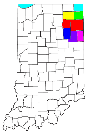
Public school districts: East Allen County Schools (yellow), Fort Wayne Community Schools (pink), Northwest Allen County Schools (blue), and Southwest Allen County Schools (green).
Allen County is home of Indiana University-Purdue University Fort Wayne (IPFW), with an enrollment of 14,192, it is the fifth-largest public university campus in Indiana. The county also holds the main campus of the Northeast Region of Ivy Tech Community College, the second-largest public community college campus in Indiana. Indiana University maintains the third public higher educational facility in the city with the Fort Wayne Center for Medical Education, a branch of the IU School of Medicine.
Religious-affiliated schools in the county include the University of Saint Francis (Roman Catholic), Concordia Theological Seminary (Lutheran), and Indiana Wesleyan University (Wesleyan Church). Business and technical schools include Indiana Institute of Technology (IIT) as well as regional branches of Trine University, Brown Mackie College, Harrison College, ITT Technical Institute, and International Business College.
Public education is offered in the four districts of East Allen County Schools, Fort Wayne Community Schools, Northwest Allen County Schools, and Southwest Allen County Schools. By means of private education, the Roman Catholic Diocese of Fort Wayne-South Bend operate 13 schools within Allen County, while Lutheran Schools of Indiana operate 14 schools within the county. In addition, Blackhawk Christian School and Canterbury School offer private K-12 education in Fort Wayne, while Amish Parochial Schools of Indiana has schools through eighth grade in rural eastern Allen County.[23]
Libraries[]
Fort Wayne and Allen County residents have been served by the Allen County Public Library (ACPL) and its thirteen branches since its founding in 1895 as the Fort Wayne Public Library. The entire library system began an $84.1 million overhaul of its branches in 2002, finishing work by 2007.[24] The centerpiece, the Main Library Branch, now covers 367,000 square feet (34,100 m2), featuring an art gallery, underground parking garage, bookstore, café, and community auditorium.[25] According to data from 2005, 5.4 million materials were borrowed by patrons, and 2.5 million visits were made throughout the library system.[26] The Fred J. Reynolds Historical Genealogy Department, located in the Main Library Branch, is the largest public genealogy department in the United States, home to more than 350,000 printed volumes and 513,000 items of microfilm and microfiche.[27]
Parks[]
In addition to the Fort Wayne Parks and Recreation department (see List of parks in Fort Wayne, Indiana), Allen County Parks currently operates four parks:
- Fox Island (southwest Allen County near Aboite)
- Metea (northeast Allen County near Leo)
- Payton (northern Allen County near Huntertown)
- Cook’s Landing (northern Allen County on Coldwater Rd.)
Allen County Parks are only partially tax supported. Operating expenses must be met through user and program fees. Admission is $2.00 per person age 7 and older. Passes are available on an annual basis (good for one year from purchase date) starting at $15.00. Activities at various parks include hiking, swimming, fishing, sledding, cross-country skiing (rentals available), playgrounds, picnic areas, play fields, and many nature-based programs for all ages. Wheeled vehicles (except wheelchairs) are not permitted on trails, and pets are not permitted in the state nature preserve areas (clearly marked).[28]
Geography[]


The county seat of Allen County, Fort Wayne.
According to the 2000 census, the county has a total area of 660.10 square miles (1,709.7 km2), of which 657.25 square miles (1,702.3 km2) (or 99.57%) is land and 2.85 square miles (7.4 km2) (or 0.43%) is water.[29] It is the largest county in Indiana, land-wise, but ranks as a 'small county' in comparison with the western states.
Adjacent counties[]
Allen County is one of the few counties in the United States to border as many as nine counties. Indiana actually has two such counties, with nearby Grant County also bordering nine others. Allen and Grant Counties share Huntington and Wells Counties as common neighbors.
- Noble County (northwest)
- DeKalb County (northeast)
- Defiance County, Ohio (northeast)
- Paulding County, Ohio (east)
- Van Wert County, Ohio (southeast)
- Adams County (southeast)
- Wells County (southwest)
- Huntington County (southwest)
- Whitley County (west)
Cities, towns, and townships[]
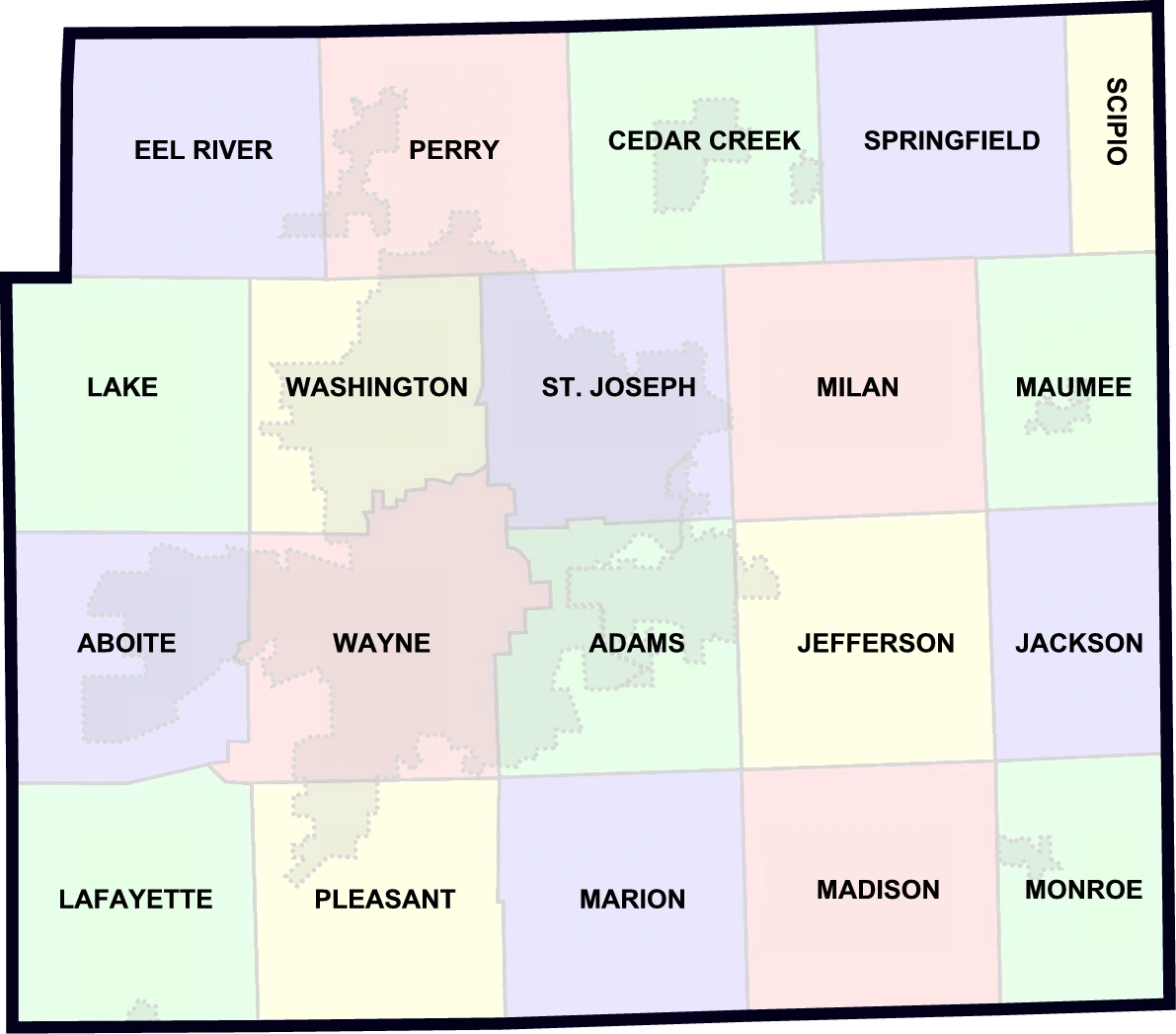
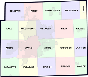
Allen County townships, with the areas of gray representing incorporated cities and towns.
Cities
Towns
|
Unincorporated
|
|
Extinct
|
Townships
|
|
Transportation[]
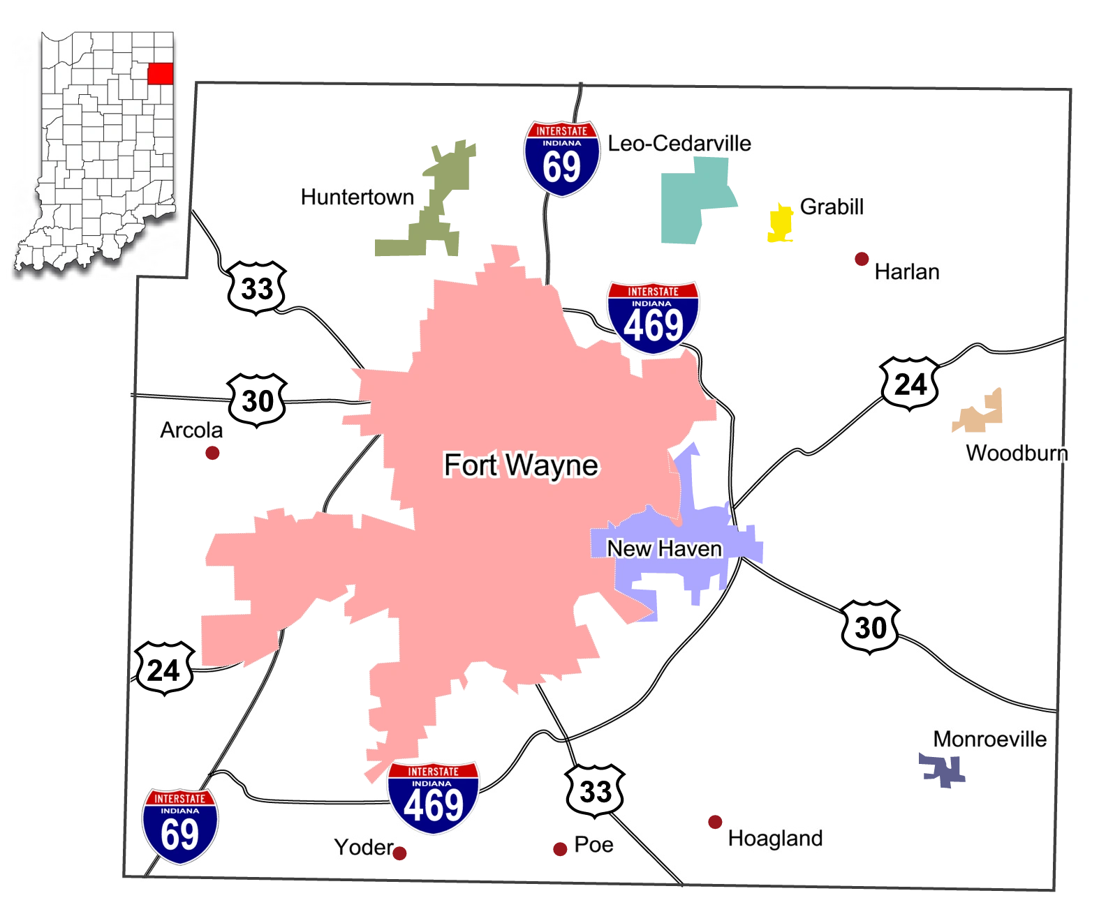
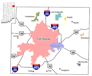
Map of Allen County, Indiana with municipalities and major roadways. Unincorporated towns represented by red dot.
Highways[]
|
|
Airports[]
- Fort Wayne International Airport
- Smith Field
Railroads[]
- Chicago Fort Wayne and Eastern Railroad
- CSX Transportation
- Maumee and Western Railroad
- Norfolk Southern Railway
See also[]
- National Register of Historic Places listings in Allen County, Indiana
References[]
- ^ "Find a County". National Association of Counties. http://www.naco.org/Counties/Pages/FindACounty.aspx. Retrieved 2011-06-07.
- ^ Fort Wayne Facts. Retrieved 2008-02-27.
- ^ Fort Wayne Facts - City of Fort Wayne. Retrieved on 2008-04-29.
- ^ a b Fort Wayne: Economy - City-Data. Retrieved on 2008-04-29.
- ^ a b Indiana Code. "Title 36, Article 2, Section 3". IN.gov. http://www.in.gov/legislative/ic/code/title36/ar2/ch3.html. Retrieved 2008-09-16.
- ^ a b c Indiana Code. "Title 2, Article 10, Section 2" (PDF). IN.gov. http://www.in.gov/legislative/ic/code/title3/ar10/ch2.pdf. Retrieved 2008-09-16.
- ^ http://www.in.gov/judiciary/allen
- ^ "Indiana Senate Districts". State of Indiana. http://www.in.gov/sos/elections/3006.htm.
- ^ "Indiana House Districts". State of Indiana. http://www.in.gov/sos/elections/3005.htm.
- ^ "2008 Presidential General Election Results - Indiana". https://uselectionatlas.org/RESULTS/state.php?year=2008&off=0&elect=0&fips=18&f=0.
- ^ Bloch, Matthew; Buchanan, Larry; Katz, Josh; Quealy, Kevin (2018-07-25). "An Extremely Detailed Map of the 2016 Presidential Election" (in en-US). The New York Times. ISSN 0362-4331. https://www.nytimes.com/interactive/2018/upshot/election-2016-voting-precinct-maps.html,%20https://www.nytimes.com/interactive/2018/upshot/election-2016-voting-precinct-maps.html.
- ^ Park, Alice; Smart, Charlie; Taylor, Rumsey; Watkins, Miles (2021-02-02). "An Extremely Detailed Map of the 2020 Election" (in en-US). The New York Times. ISSN 0362-4331. https://www.nytimes.com/interactive/2021/upshot/2020-election-map.html.
- ^ "2000 Gubernatorial General Election Results - Indiana". https://uselectionatlas.org/RESULTS/state.php?year=2000&fips=18&off=5&elect=0&f=0.
- ^ "2004 Senatorial General Election Results - Indiana". https://uselectionatlas.org/RESULTS/state.php?year=2004&off=3&class=3&elect=0&fips=18&f=0.
- ^ "Voteview | District View". https://voteview.com/district/Fort%20Wayne,%20IN.
- ^ Leip, David. "Dave Leip's Atlas of U.S. Presidential Elections". http://uselectionatlas.org/RESULTS.
- ^ Allen County Government - Commissioners. Retrieved on 2008-07-06.
- ^ Counts, Will; Jon Dilts (1991). The 92 Magnificent Indiana Courthouses. Bloomington, Indiana: Indiana University Press. pp. 10–11. ISBN 978-0253336385.
- ^ a b "Monthly Averages for Fort Wayne, Indiana". The Weather Channel. http://www.weather.com/weather/wxclimatology/monthly/graph/USIN0211. Retrieved 2011-01-27.
- ^ "American FactFinder". United States Census Bureau. http://factfinder.census.gov. Retrieved 2008-01-31.
- ^ Linsenmayer, Steve, A foot in the door: 300 refugees from Burma will move to Fort Wayne this year; getting them settled is a huge and challenging task , Fort Wayne News-Sentinel, July 12, 2007. (Accessed January 27, 2008)
- ^ Forbes Best Places For Business And Careers Fort Wayne Profile. Retrieved on 2009-03-28.
- ^ The Amish Schools of Indiana: Faith in Education, by Stephen Bowers; p. 40 Harroff. Retrieved on 2009-07-25.
- ^ Perez, Pamela, (2001-09-27). The debate over the library It could revitalize downtown, say supporters. It's too big, say opponents. The News-Sentinel. Retrieved on 2009-02-06.
- ^ Allen County Public Library - Main Library Branch. Allen County Public Library. Retrieved on 2008-05-17.
- ^ Allen County Public Library Expansion and Renovation Project. Allen County Public Library. Retrieved on 2008-05-27.
- ^ Allen County Public Library - Genealogy. Allen County Public Library. Retrieved on 2008-06-10.
- ^ Allen County Parks. Allen County Parks. Retrieved on 2009-06-05.
- ^ "Census 2000 U.S. Gazetteer Files: Counties". United States Census. http://www.census.gov/tiger/tms/gazetteer/county2k.txt. Retrieved 2011-02-06.
Further reading[]
- Forstall, Richard L. (editor) (1996). Population of states and counties of the United States: 1790 to 1990 : from the twenty-one decennial censuses. United States Department of Commerce, Bureau of the Census, Population Division. ISBN 0-934213-48-8.
External links[]
- Allen County official website
- Allen County Parks Department
- ARCH, Inc. (Allen County historic architecture preservation group)
- Fort Wayne/Allen County Convention and Visitors Bureau
- Fort Wayne–Allen County Economic Development Alliance

|
Noble County | DeKalb County and Defiance County, Ohio |
| |
| Whitley County | Paulding County, Ohio | |||
 Allen County, Indiana | ||||
| Wells County and Huntington County | Van Wert County, Ohio and Adams County |
Template:Allen County High Schools
| |||||||||||||||||||||||
| ||||||||||||||||
| This page uses content from the English language Wikipedia. The original content was at Allen County, Indiana. The list of authors can be seen in the page history. As with this Familypedia wiki, the content of Wikipedia is available under the Creative Commons License. |