| Bezirk Güssing | |
|---|---|
| — District — | |
 |
|
| Country | Austria |
| State | Burgenland |
| Number of municipalities | 28 |
| Area | |
| • Total | 486.71 km2 (187.92 sq mi) |
| Population (2012) | |
| • Total | 26,636 |
| Time zone | CET (UTC+1) |
| • Summer (DST) | CEST (UTC+2) |
| NUTS code | ? |
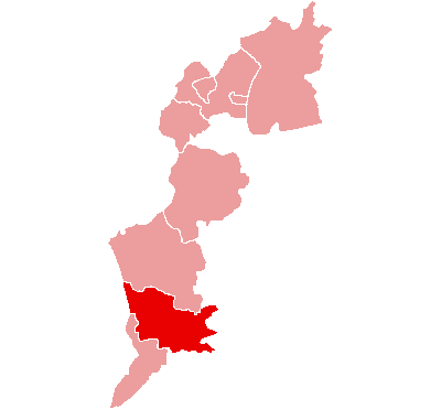
The Bezirk Güssing (Croatian: Kotar Novi Grad) is an administrative district (Bezirk) in the federal state of Burgenland, Austria, bordering on Vas Megye (County) Hungary, of which it had been a part prior to 1921.
Area of the district is 486.71 km², with a population of 26,636 (2012), and population density 55 persons per km². Administrative center of the district is Güssing.
Administrative divisions[]
The district consists of the below municipalities and towns, the former Hungarian names of some of which are given in parentheses:
- Bildein (361)
- Bocksdorf (800)
- Burgauberg-Neudauberg (1,375)
- Eberau (1,004)
- Gerersdorf-Sulz (1,044)
- Großmürbisch (262)
- Güssing (3,798)
- Güttenbach (938)
- Hackerberg (363)
- Heiligenbrunn (837)
- Heugraben (222)
- Inzenhof (328)
- Kleinmürbisch (250)
- Kukmirn (2,011)
- Moschendorf (407)
- Neuberg im Burgenland (1,020)
- Neustift bei Güssing (507)
- Olbendorf (1,408)
- Ollersdorf im Burgenland (975)
- Rauchwart (458)
- Rohr im Burgenland (382)
- Sankt Michael im Burgenland (1,018)
- Stegersbach (2,558)
- Stinatz (1,412)
- Strem (928)
- Tobaj (1,393)
- Tschanigraben (72)
- Wörterberg (505)
| ||||||||||
| This page uses content from the English language Wikipedia. The original content was at Güssing District. The list of authors can be seen in the page history. As with this Familypedia wiki, the content of Wikipedia is available under the Creative Commons License. |