| ||||||||||||||
| Greenwood County, Kansas | |
 Location in the state of Kansas | |
 Kansas's location in the U.S. | |
| Founded | August 25, 1855 |
|---|---|
| Named for | Alfred B. Greenwood |
| Seat | Eureka |
| Area - Total - Land - Water |
1,152.59 sq mi (2,985 km²) 1,139.67 sq mi (2,952 km²) 12.92 sq mi (33 km²), 1.12% |
| Population - (2010) - Density |
6,689 6.2/sq mi (2.4/km²) |
| Time zone | Central: UTC-6/-5 |
| Website | GreenwoodCounty.org |
Greenwood County (county code GW) is a county located in Southeast Kansas, in the Central United States. As of the 2010 census, the county population was 6,689.[1] Its county seat and most populous city is Eureka.[2]
Law and government[]
Greenwood County was a prohibition, or "dry", county until the Kansas Constitution was amended in 1986 and voters approved the sale of alcoholic liquor by the individual drink with a 30% food sales requirement.[3]
Geography[]
According to the 2000 census, the county has a total area of 1,152.59 square miles (2,985.2 km2), of which 1,139.67 square miles (2,951.7 km2) (or 98.88%) is land and 12.92 square miles (33.5 km2) (or 1.12%) is water.[4]
Adjacent counties[]
- Lyon County (north)
- Coffey County (northeast)
- Woodson County (east)
- Wilson County (southeast)
- Elk County (south)
- Butler County (west)
- Chase County (northwest)
Demographics[]
| Historical populations | |||
|---|---|---|---|
| Census | Pop. | %± | |
| 1860 | 769 | [5] | |
| 1870 | 3,484 | 353.1% | |
| 1880 | 10,548 | 202.8% | |
| 1890 | 16,309 | 54.6% | |
| 1900 | 16,196 | −0.7% | |
| 1910 | 16,060 | −0.8% | |
| 1920 | 14,715 | −8.4% | |
| 1930 | 19,235 | 30.7% | |
| 1940 | 16,495 | −14.2% | |
| 1950 | 13,574 | −17.7% | |
| 1960 | 11,253 | −17.1% | |
| 1970 | 9,141 | −18.8% | |
| 1980 | 8,764 | −4.1% | |
| 1990 | 7,847 | −10.5% | |
| 2000 | 7,673 | −2.2% | |
| 2010 | 6,689 | −12.8% | |

Population pyramid
As of the U.S. Census in 2000,[6] there were 7,673 people, 3,234 households, and 2,153 families residing in the county. The population density was 7 people per square mile (3/km²). There were 4,273 housing units at an average density of 4 per square mile (1/km²). The racial makeup of the county was 96.53% White, 0.83% Native American, 0.14% Black or African American, 0.10% Asian, 0.81% from other races, and 1.58% from two or more races. Hispanic or Latino of any race were 1.72% of the population.
There were 3,234 households out of which 27.10% had children under the age of 18 living with them, 56.50% were married couples living together, 6.60% had a female householder with no husband present, and 33.40% were non-families. 30.30% of all households were made up of individuals and 16.80% had someone living alone who was 65 years of age or older. The average household size was 2.31 and the average family size was 2.86.
In the county the population was spread out with 23.70% under the age of 18, 6.50% from 18 to 24, 23.20% from 25 to 44, 23.70% from 45 to 64, and 22.80% who were 65 years of age or older. The median age was 43 years. For every 100 females there were 95.50 males. For every 100 females age 18 and over, there were 91.50 males.
The median income for a household in the county was $30,169, and the median income for a family was $38,140. Males had a median income of $27,021 versus $19,356 for females. The per capita income for the county was $15,976. About 8.20% of families and 12.50% of the population were below the poverty line, including 16.20% of those under age 18 and 10.10% of those age 65 or over.
Cities and towns[]
Incorporated cities[]
Name and population (2004 estimate):
- Eureka, 2,821 (county seat)
- Madison, 823
- Severy, 359
- Hamilton, 333
- Fall River, 156
- Virgil, 112
- Climax, 64
Unincorporated communities[]
- Lamont
- Neal
- Reece
Townships[]
Greenwood County is divided into fifteen townships. The city of Eureka is considered governmentally independent and is excluded from the census figures for the townships. In the following table, the population center is the largest city (or cities) included in that township's population total, if it is of a significant size.
| Township | FIPS | Population center |
Population | Population density /km² (/sq mi) |
Land area km² (sq mi) |
Water area km² (sq mi) |
Water % | Geographic coordinates |
|---|---|---|---|---|---|---|---|---|
| Bachelor | 03625 | 230 | 1 (4) | 155 (60) | 1 (0) | 0.70% | ||
| Eureka | 21825 | 451 | 3 (8) | 149 (58) | 2 (1) | 1.50% | ||
| Fall River | 22800 | 229 | 1 (4) | 154 (60) | 2 (1) | 1.13% | ||
| Janesville | 35000 | 548 | 1 (4) | 371 (143) | 2 (1) | 0.62% | ||
| Lane | 38425 | 167 | 1 (3) | 138 (53) | 1 (0) | 0.52% | ||
| Madison | 44075 | 1,155 | 4 (9) | 320 (124) | 3 (1) | 0.85% | ||
| Otter Creek | 53650 | 211 | 1 (2) | 290 (112) | 2 (1) | 0.55% | ||
| Pleasant Grove | 56375 | 52 | 0 (1) | 150 (58) | 2 (1) | 1.57% | ||
| Quincy | 58175 | 163 | 1 (3) | 155 (60) | 1 (0) | 0.38% | ||
| Salem | 62650 | 35 | 0 (0) | 233 (90) | 2 (1) | 0.89% | ||
| Salt Springs | 62875 | 463 | 3 (7) | 182 (70) | 10 (4) | 5.16% | ||
| Shell Rock | 64600 | 173 | 1 (3) | 136 (53) | 1 (0) | 0.87% | ||
| South Salem | 66925 | 127 | 1 (1) | 224 (87) | 3 (1) | 1.13% | ||
| Spring Creek | 67425 | 154 | 1 (3) | 139 (54) | 1 (1) | 0.93% | ||
| Twin Grove | 71825 | 601 | 4 (11) | 148 (57) | 1 (0) | 0.57% | ||
| Sources: "Census 2000 U.S. Gazetteer Files". U.S. Census Bureau, Geography Division. http://www.census.gov/geo/www/gazetteer/places2k.html. | ||||||||
Education[]
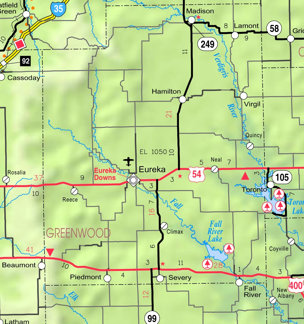

2005 KDOT Map of Greenwood County (map legend)
Unified school districts[]
See also[]
- National Register of Historic Places listings in Greenwood County, Kansas
Information on this and other counties in Kansas
- List of counties in Kansas
- List of Kansas county name etymologies
- National Register of Historic Places listings in Kansas
- Kansas locations by per capita income
Other information for Kansas
- List of cities in Kansas
- List of unified school districts in Kansas
- List of colleges and universities in Kansas
References[]
- ^ "2010 County Population and Housing Occupancy Status". U.S. Census Bureau. http://factfinder2.census.gov/faces/tableservices/jsf/pages/productview.xhtml?pid=DEC_10_PL_GCTPL2.ST05&prodType=table. Retrieved March 31, 2011.
- ^ "Find a County". National Association of Counties. http://www.naco.org/Counties/Pages/FindACounty.aspx. Retrieved 2011-06-07.
- ^ "Map of Wet and Dry Counties". Alcoholic Beverage Control, Kansas Department of Revenue. November 2006. http://www.ksrevenue.org/abcwetdrymap.htm. Retrieved 2007-12-28.
- ^ "Census 2000 U.S. Gazetteer Files: Counties". United States Census. http://www.census.gov/tiger/tms/gazetteer/county2k.txt. Retrieved 2011-02-13.
- ^ The population for 1860 excludes the portion of Madison County annexed between 1860 and 1870. Madison's total population was 686 in 1860.
- ^ "American FactFinder". United States Census Bureau. http://factfinder.census.gov. Retrieved 2008-01-31.
Further reading[]
- History of the State of Kansas; William G. Cutler; A.T. Andreas Publisher; 1883. (Online HTML eBook)
- Kansas : A Cyclopedia of State History, Embracing Events, Institutions, Industries, Counties, Cities, Towns, Prominent Persons, Etc; 3 Volumes; Frank W. Blackmar; Standard Publishing Co; 944 / 955 / 824 pages; 1912. (Volume1 - Download 54MB PDF eBook),(Volume2 - Download 53MB PDF eBook), (Volume3 - Download 33MB PDF eBook)
External links[]
- Official sites
- Additional information
- Maps
- Greenwood County Map, KDOT
- Kansas Highway Map, KDOT
- Kansas Railroad Map, KDOT
- Kansas School District Boundary Map, KSDE

|
Chase County | Lyon County | Coffey County |
|
| Butler County | Woodson County | |||
 Greenwood County, Kansas | ||||
| Elk County | Wilson County |
| |||||
| This page uses content from the English language Wikipedia. The original content was at Greenwood County, Kansas. The list of authors can be seen in the page history. As with this Familypedia wiki, the content of Wikipedia is available under the Creative Commons License. |