Familypedia
Advertisement
Main Births etc
Bezirk Grieskirchen
—  District  —
Karte Aut Ooe GR
Country Austria
State Upper Austria
Number of municipalities 34
Area
 • Total 579.0 km2 (223.6 sq mi)
Population (2001)
 • Total 61,960
Time zone CET (UTC+1)
 • Summer (DST) CEST (UTC+2)
NUTS code

Bezirk Grieskirchen is a district of the state of Upper Austria in Austria.

Municipalities[]

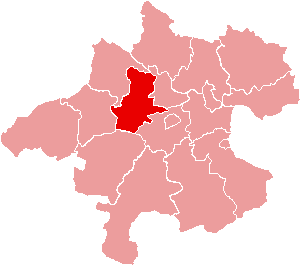
Towns (Städte) are indicated in boldface; market towns (Marktgemeinden) in italics; suburbs, hamlets and other subdivisions of a municipality are indicated in small characters.

  • Aistersheim (786)
  • Bad Schallerbach (3287)
  • Bruck-Waasen (2302)
  • Eschenau im Hausruckkreis (1176)
  • Gallspach (2575)
  • Gaspoltshofen (3609)
  • Geboltskirchen (1412)
  • Grieskirchen (4807)
  • Haag am Hausruck (2047)
  • Heiligenberg (710)
  • Hofkirchen an der Trattnach (1510)
  • Kallham (2543)
  • Kematen am Innbach (1262)
  • Meggenhofen (1236)
  • Michaelnbach (1232)
  • Natternbach (2338)
  • Neukirchen am Walde (1686)
  • Neumarkt im Hausruckkreis (1447)
  • Peuerbach (2234)
  • Pollham (915)
  • Pötting (541)
  • Pram (1840)
  • Rottenbach (1009)
  • Schlüßlberg (2998)
  • Sankt Agatha (2119)
  • Sankt Georgen bei Grieskirchen (967)
  • Sankt Thomas (460)
  • Steegen (1124)
  • Taufkirchen an der Trattnach (2093)
  • Tollet (871)
  • Waizenkirchen (3660)
  • Wallern an der Trattnach (2874)
  • Weibern (1587)
  • Wendling (833)

External links[]

Coordinates: 48°14′46″N 13°46′48″E / 48.246, 13.78


This page uses content from the English language Wikipedia. The original content was at Grieskirchen District. The list of authors can be seen in the page history. As with this Familypedia wiki, the content of Wikipedia is available under the Creative Commons License.
Advertisement