| Main | Births etc |
|---|
| City of Ironton | |
|---|---|
| — City — | |
 |
|
 |
|
| Coordinates: Coordinates: | |
| Country | United States |
| State | Ohio |
| County | Lawrence |
| Founded | 1849 |
| Incorporated | |
| Government | |
| • Mayor | Rich Blankenship |
| Area[1] | |
| • City | 4.46 sq mi (11.55 km2) |
| • Land | 4.16 sq mi (10.77 km2) |
| • Water | 0.30 sq mi (0.78 km2) |
| Elevation | 551 ft (168 m) |
| Population (2010)[2] | |
| • City | 11,129 |
| • Estimate (2012[3]) | 11,067 |
| • Density | 2,675.2/sq mi (1,032.9/km2) |
| • Metro | 288,648 |
| Time zone | EST (UTC-5) |
| • Summer (DST) | EDT (UTC-4) |
| ZIP code | 45638 |
| Area code(s) | 740 |
| FIPS code | 39-37464[4] |
| GNIS feature ID | 1076122[5] |
| Website | ironton-ohio.com |
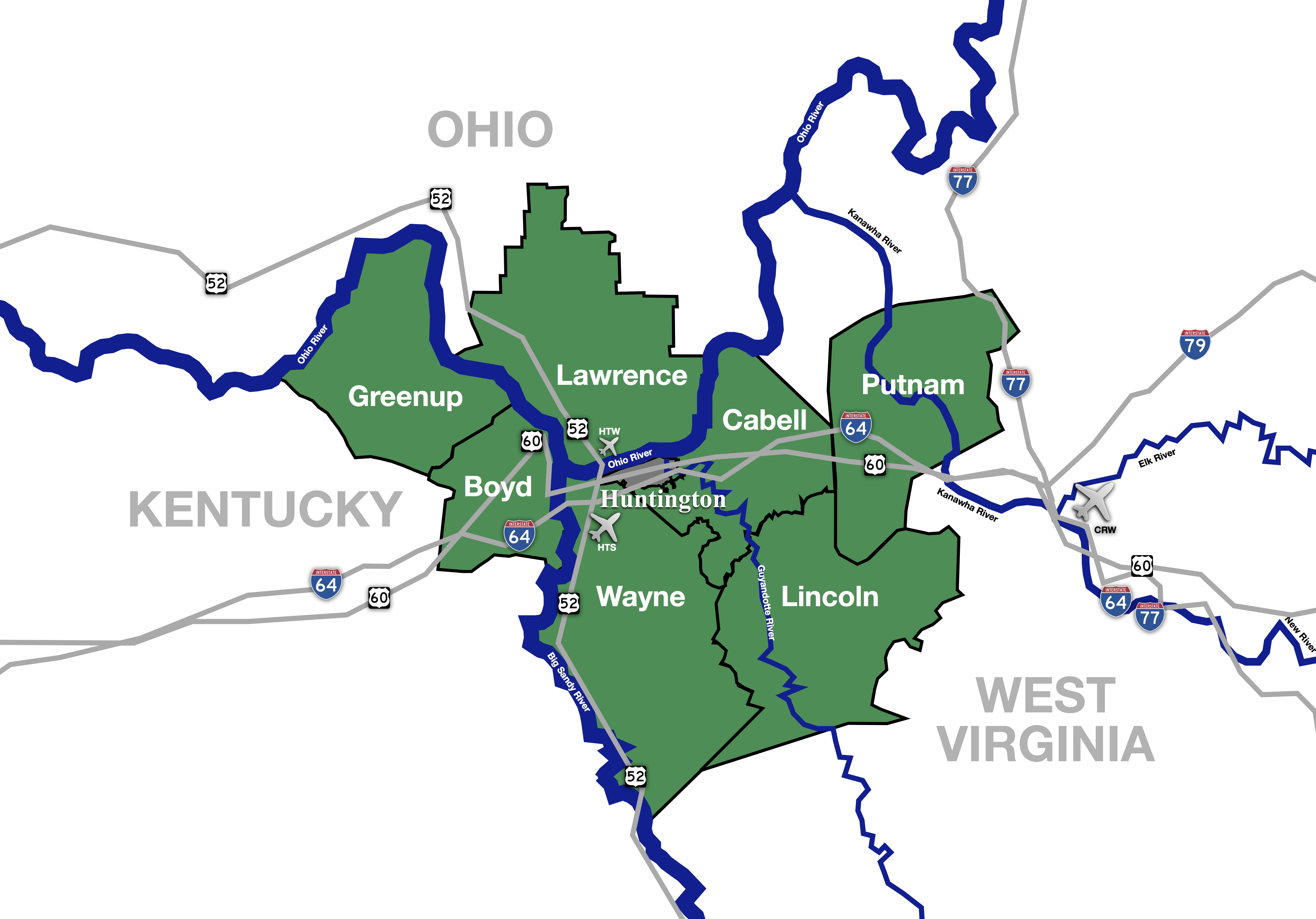
Ironton is a city in the U.S. state of Ohio and the county seat of Lawrence County.[6] The municipality is located in southern Ohio along the Ohio River. The city includes the Downtown Ironton Historic District.
The population was 11,129 at the 2010 census. Ironton is part of the Huntington-Ashland, WV-KY-OH, Metropolitan Statistical Area (MSA). As of the 2010 census, the MSA had a population of 287,702. New definitions from February 28, 2013 placed the population at 363,000.[7]
The city has a long history with the iron industry. It had one of the first professional football teams.
History[]
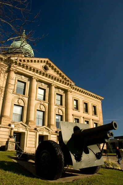
The Lawrence County, Ohio courthouse in Ironton, Ohio
Ironton was founded in 1849 by John Campbell,[8] who was a prominent pig iron manufacturer in the area. Interested in expanding his foundry business, and due to the area's rich iron-ore content (particularly in the hills to the north), he became interested in the lands surrounding what would later become the city of Ironton. The location of Ironton was chosen for its position along the Ohio River, which would allow for transport of the much-needed commodity, iron-ore, and the slope of the land itself, which facilitated movement of the raw material to the local blast furnaces.
Between 1850 and 1890, Ironton was one of the foremost producers of iron in the world. England, France, and Russia all purchased iron for warships from here due to the quality; iron produced in Ironton and surrounding areas was used for the USS Monitor, the United States' first ironclad ship.[8] There were more than ninety furnaces in operation at the peak of production in the late 19th century.[8] The wealth created from the pig-iron industry led to the construction of many opulent residences.
With much wealth pouring into the city from the iron industry, new industries opened that included soap and nail production. The Detroit, Toledo and Ironton Railroad, which stretched through two states, helped fuel Henry Ford's plants in Michigan. The city had a street railway, the Ironton Petersburg Street Railway, and four daily newspapers and a few foreign-language publications. Ironton was also known for its lax attitude towards sin and vice. It was home to a racetrack, numerous saloons, and brothels. Numerous chapels offered "quick and quiet" marriages.
Underground Railroad and Civil War[]
Ironton has been credited as being part of the Underground Railroad that helped runaway slaves flee the South. Both the founder of the city and other city notables helped hide slaves in their homes.[9]
During the American Civil War, local military regiments were mustered, quartered, and trained at Camp Ironton, a military post located at the county fairgrounds. Among them was the 91st Ohio Infantry, which was organized at Camp Ironton on August 26, 1862.
Changing economics of iron industry[]
The downfall of Ironton came as the market for iron changed. The quality of the iron that had once made Ironton one of the leading producers of pig iron was no longer considered as desirable. All of the easily accessible iron had been mined by 1899, and the continued production costs began to outweigh the benefit. Also, the nation was making the transition from a demand for iron to steel. After a nationwide economic recession in the late 19th century, Ironton was no longer growing. The Great Depression of the 1930s and two major floods (1917, 1937) devastated the city to the point that most if not all the city's industries had closed down for good. Nevertheless, some commerce remained; the Norfolk and Western Railway built a new railroad station downtown in 1906, and it continued in operation throughout the period.[10]
As the iron industries closed, Ironton had little with which to replace them. A labor-oriented town, Ironton managed to keep alive by trying to attract heavy industry to the region. Companies like Allied Signal and Alpha Portland Cement did build in town The continued dependency on labor industries has severely hurt the region as a whole, and Ironton even more so. By 2004, both Alpha Portland Cement and Allied Signal were gone, and Ironton had shrunk by almost 50%.
Professional Football & The Thanksgiving Day Football tradition[]
Ironton had one of the first professional football teams in the United States, called the Ironton Tanks. The team was first organized in 1919 and had a record of 85 wins, 19 losses, 14 ties, including an undefeated season in 1922, a state championship in 1926 and dual victories in 1930 over National Football League (NFL) powerhouses the Chicago Bears and New York Giants. The football field previously used by the Tanks is now home to the Ironton High School Football team, the Ironton Fighting Tigers.
The Tanks were the originators of what is now the National Football League's Detroit Lions Thanksgiving Day Game tradition. The Tanks played a game the day after Thanksgiving with the Lombards, a crosstown rival on Friday Nov 26, 1920 winning 26-0. They began the actual string of Thanksgiving Day games by defeating the Huntington Boosters 12-0 on Nov 30, 1922. The Tanks continued playing on this national holiday each year thru 1930, which was the Tanks final season. Several Tank players (including Glenn Presnell) continued their football careers by joining the nearby Portsmouth Spartans who continued the annual tradition until their demise after the 1933 season. The Spartans assets were acquired and moved to Detroit where they were renamed the Lions. Asked by their new owner (G.A. Richards) about ways to improve ticket sales, the players replied that they always got a good turnout on Thanksgiving Day. He promptly scheduled the first Thanksgiving Day game in Detroit.[11]
Geography and climate[]
Ironton is located at (38.530720, -82.678309).[12]
According to the United States Census Bureau, the city has a total area of 4.46 square miles (11.55 km2), of which, 4.16 square miles (10.77 km2) is land and 0.30 square miles (0.78 km2) is water.[1]
Ironton rests within the northern limits of a humid subtropical climate (Koppen Cfa) which is typical of southern Ohio and northern Kentucky. The region experiences four distinct seasons. Winters are cool to cold with mild periods and summers are generally hot and humid, with significant precipitation year round. Ironton is largely transitional in its plant life, sharing traditionally northern trees like the blue spruce along with Magnolia and the occasional Needle Palm from the Upland South.
Demographics[]
| Historical populations | |||
|---|---|---|---|
| Census | Pop. | %± | |
| 1860 | 3,691 | ||
| 1870 | 5,686 | 54.1% | |
| 1880 | 8,857 | 55.8% | |
| 1890 | 10,939 | 23.5% | |
| 1900 | 11,868 | 8.5% | |
| 1910 | 13,147 | 10.8% | |
| 1920 | 14,007 | 6.5% | |
| 1930 | 16,021 | 14.4% | |
| 1940 | 15,851 | −1.1% | |
| 1950 | 16,333 | 3.0% | |
| 1960 | 15,745 | −3.6% | |
| 1970 | 15,030 | −4.5% | |
| 1980 | 14,178 | −5.7% | |
| 1990 | 12,751 | −10.1% | |
| 2000 | 11,211 | −12.1% | |
| 2010 | 11,129 | −0.7% | |
| Est. 2012 | 11,067 | −1.3% | |
| Sources:[13][14][4][15] | |||
2010 census[]
As of the census[2] of 2010, there were 11,129 people, 4,817 households, and 2,882 families residing in the city. The population density was 2,675.2 inhabitants per square mile (1,032.9 /km2). There were 5,382 housing units at an average density of 1,293.8 per square mile (499.5 /km2). The racial makeup of the city was 92.6% White, 4.7% African American, 0.2% Native American, 0.3% Asian, 0.1% from other races, and 2.1% from two or more races. Hispanic or Latino of any race were 0.5% of the population.
There were 4,817 households of which 28.1% had children under the age of 18 living with them, 39.0% were married couples living together, 15.3% had a female householder with no husband present, 5.5% had a male householder with no wife present, and 40.2% were non-families. 35.9% of all households were made up of individuals and 16.2% had someone living alone who was 65 years of age or older. The average household size was 2.23 and the average family size was 2.87.
The median age in the city was 42.1 years. 21.1% of residents were under the age of 18; 8.6% were between the ages of 18 and 24; 23.8% were from 25 to 44; 27.1% were from 45 to 64; and 19.2% were 65 years of age or older. The gender makeup of the city was 47.1% male and 52.9% female.
2000 census[]
As of the census[4] of 2000, there were 11,211 people, 4,906 households, and 3,022 families residing in the city. The population density was 2,711.3 people per square mile (1,048.1/km²). There were 5,507 housing units at an average density of 1,331.8 per square mile (514.8/km²). The racial makeup of the city was 93.33% White, 5.24% African American, 0.09% Native American, 0.25% Asian, 0.02% Pacific Islander, 0.09% from other races, and 0.99% from two or more races. Hispanic or Latino of any race were 0.51% of the population.
There were 4,906 households out of which 25.9% had children under the age of 18 living with them, 43.6% were married couples living together, 14.3% had a female householder with no husband present, and 38.4% were non-families. 35.3% of all households were made up of individuals and 18.0% had someone living alone who was 65 years of age or older. The average household size was 2.22 and the average family size was 2.85.
In the city the population was spread out with 21.8% under the age of 18, 7.9% from 18 to 24, 24.6% from 25 to 44, 24.5% from 45 to 64, and 21.2% who were 65 years of age or older. The median age was 42 years. For every 100 females there were 82.2 males. For every 100 females age 18 and over, there were 77.0 males.
The median income for a household in the city was $23,585, and the median income for a family was $35,014. Males had a median income of $31,702 versus $24,190 for females. The per capita income for the city was $15,391. About 17.2% of families and 23.1% of the population were below the poverty line, including 32.4% of those under age 18 and 17.0% of those age 65 or over.
Government and politics[]
The city is managed by an seven-member city council, the current members of which include Chairman Kevin Waldo, Mike Lutz, Beth Rist, Dave Frazer, Bob Cleary, Aaron Bollinger, Phillip Heald and Jim Tordiff. The elected mayor is Rich Blankenship.[16]
Downtown Historic District[]
The Downtown Ironton Historic District was added to the National Register of Historic Places listings in Lawrence County, Ohio on January 8, 2009, It includes portions of 2nd, 3rd, 4th, 5th, Center Streets, Park Avenue, Vernon Street, and Bobby Bare Boulevard. The district includes Early Commercial architecture and Modern architecture representing periods from 1850 through 1974. The buildings serve commercial trade, government, social, and transportation industries, and include businesses, City Hall, financial institutions, meeting halls, United States Post Office buildings, professional service buildings and railrioad industry-related structures. [17]
Education[]
There are three public and one private elementary schools, one public and one private high schools, and a community college in Ironton. One non-traditional school also serves the city. The public city schools are currently building new facilities and are subsequently housed at in various buildings.
| School | Grade | Description |
|---|---|---|
| Saint Lawrence Central Elementary School | K-6 | Private, Catholic kindergarten & elementary school |
| Ironton Middle School | 6-8 | Opened in 2009. Ironton City School District. |
| Ironton High School | 9-12 | Sole public high school for the city; houses grades 9-12. |
| Lawrence County Board of MR/DD Open Door | Serves the educational needs all of Lawrence County's MR/DD citizens. | |
| Ohio University Southern Campus | The largest branch of Ohio University[8] | |
| Saint Joseph Central High School | 7-12 | Private, Catholic junior high & high school; smallest school in Ohio |
| Ironton Elementary School | K-5 | Opened in 2009. Ironton City School District. |
Portions outside of the Ironton city limits are served by the Dawson-Bryant Local School District and the Rock Hill Local School District. Both districts have Ironton mailing addresses.
Culture[]
Annual cultural events and fairs[]
| Name | Location | Date | Comments |
|---|---|---|---|
| Charity Fair | St. Joseph Central Catholic High School | Memorial Day | This involves carnival games, crafts, inflatable rides, food, and musical acts. |
| Gus Macker Tournament | Late May, Early June | ||
| Ironmaster Days | Downtown | ||
| Ironton-Lawrence County Memorial Day Parade | Downtown | Memorial Day | The nation's oldest continuously running Memorial Day parade, it has been a tradition since 1868. The first parade was held May 5, 1868 by order of Major General John A. Logan, commander of the Grand Army of the Republic in honor of the soldiers who died fighting the Civil War. The parade has 12 separate divisions and draws tens of thousands per year .[8] |
| Rally On the River | Mid-August | A yearly motorcycle event. | |
| Oktoberfest |
Notable people[]
- Coy Bacon, former pro football player.
- Bobby Bare, Country music singer
- Terry Enyart, baseball player
- Harlan Hatcher, eighth President of the University of Michigan
- Elza Jeffords, member of the U.S. House of Representatives from Mississippi, was born in Ironton in 1826.
- William C. Lambert, achieved the second highest air victory totals for an American flying ace in the war with 21.
- Bob Lutz, former football head coach, all-time winningest coach in Ohio High School Football with 381 wins and two State Championships in 1979 and 1989.
- George McAfee, professional football Hall of Fame
- James Parks, Medal of Honor recipient (captured battle flag at the Battle of Nashville 12/16/1864)
- William Powell, Medal of Honor recipient (led 20 men and captured enemy encampment of 500 without loss of life on 11/26/1862)
- Gardner Rea, cartoonist
- Kelli Sobonya, politician
References[]
- ^ a b "US Gazetteer files 2010". United States Census Bureau. http://www.census.gov/geo/www/gazetteer/files/Gaz_places_national.txt. Retrieved 2013-01-06.
- ^ a b "American FactFinder". United States Census Bureau. http://factfinder2.census.gov/faces/nav/jsf/pages/index.xhtml. Retrieved 2013-01-06.
- ^ "Population Estimates". United States Census Bureau. http://www.census.gov/popest/data/cities/totals/2012/SUB-EST2012.html. Retrieved 2013-06-17.
- ^ a b c "American FactFinder". United States Census Bureau. http://factfinder.census.gov. Retrieved 2008-01-31.
- ^ "US Board on Geographic Names". United States Geological Survey. 2007-10-25. http://geonames.usgs.gov. Retrieved 2008-01-31.
- ^ "Find a County". National Association of Counties. http://www.naco.org/Counties/Pages/FindACounty.aspx. Retrieved 2011-06-07.
- ^ "Population statistics". http://m.whitehouse.gov/sites/default/files/omb/bulletins/2013/b13-01.pdf.
- ^ a b c d e Malloy, David E. (27 September 2006). "Ironton". Herald-Dispatch (Huntington, WV). http://www.putnamherald.com/apps/pbcs.dll/article?AID=/99999999/COMMUN/604200307/1069.
- ^ The Herald-Dispatch / 2013. "Lawrence County, Ohio: Community known for its rich history in iron and for its role in helping slaves escape via the Underground Railroad". The Herald-Dispatch. http://www.herald-dispatch.com/news/communities/x407923223/Lawrence-County-Ohio-Community-known-for-its-rich-history-in-iron-and-for-its-role-in-helping-slaves-escape-via-the-Underground-Railroad. Retrieved 2014-01-01.
- ^ Owen, Lorrie K., ed (1999). Dictionary of Ohio Historic Places. 2. =St. Clair Shores, Michigan: Somerset. p. 857.
- ^ Becker, Carl (1998). "Detroit Lions - History of the Thanksgiving day game". Home & Away: Rise & Fall Of Professional Football On Banks Of Ohio. Ohio University Press. ISBN 9780821412374.
- ^ "US Gazetteer files: 2010, 2000, and 1990". United States Census Bureau. 2011-02-12. http://www.census.gov/geo/www/gazetteer/gazette.html. Retrieved 2011-04-23.
- ^ "Number of Inhabitants: Ohio". 18th Census of the United States. U.S. Census Bureau. http://www2.census.gov/prod2/decennial/documents/37749197v1p37_ch02.pdf. Retrieved 22 November 2013.
- ^ "Ohio: Population and Housing Unit Counts". U.S. Census Bureau. http://www.census.gov/prod/cen1990/cph2/cph-2-37.pdf. Retrieved 22 November 2013.
- ^ "Incorporated Places and Minor Civil Divisions Datasets: Subcounty Population Estimates: April 1, 2010 to July 1, 2012". U.S. Census Bureau. http://www.census.gov/popest/data/cities/totals/2012/SUB-EST2012.html. Retrieved 25 November 2013.
- ^ "Government". City of Ironton, Ohio. http://www.ironton-ohio.com/gov.htm. Retrieved 3 December 2013.
- ^ "Ohio (OH), Lawrence County". National Register of Historical Places. Nationalregisterofhistoricplaces.com. http://www.nationalregisterofhistoricplaces.com/oh/Lawrence/state.html. Retrieved 2013-12-03.
External links[]
- Official City Website
- Lawrence County Ohio Genealogical and Historical Website
- The Ironton Tribune
- Rally on the River
- Ironton Community Portal
- Lawrence County Chamber of Commerce
- Ironton aLive
| |||||||||||||||||||||||

| |||||||||||||||||||||||||
| This page uses content from the English language Wikipedia. The original content was at Ironton, Ohio. The list of authors can be seen in the page history. As with this Familypedia wiki, the content of Wikipedia is available under the Creative Commons License. |