| ||||||||||||||
| Jefferson County, Texas | ||
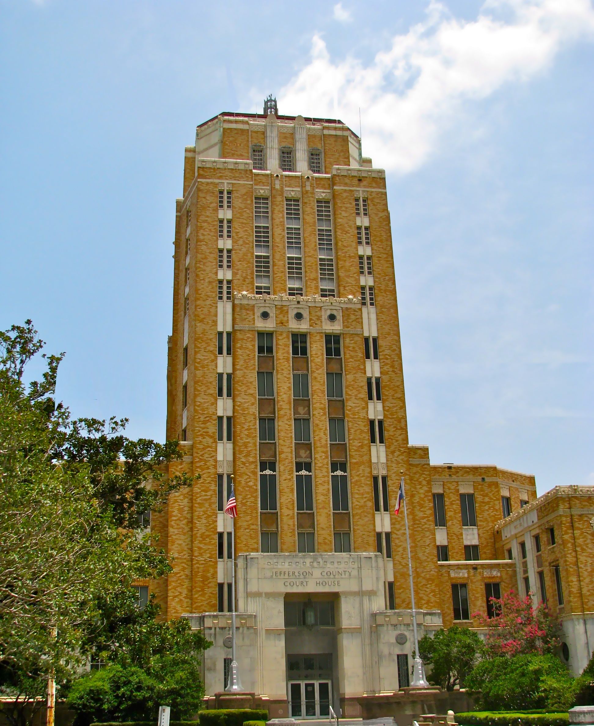 The Jefferson County Courthouse in Beaumont. The Art Deco style building was added to the National Register of Historic Places on June 17, 1982. The building is one of the few completely original Art Deco structures in Texas. The top five floors once served as the County Jail.
| ||
| ||
 Location in the state of Texas | ||
 Texas's location in the U.S. | ||
| Founded | 1836 | |
|---|---|---|
| Seat | Beaumont | |
| Area - Total - Land - Water |
1,111 sq mi (2,877 km²) 904 sq mi (2,341 km²) 208 sq mi (539 km²), 18.69% | |
| Population - (2020) - Density |
256,526 280/sq mi (108/km²) | |
| Website | www.co.jefferson.tx.us | |

Jefferson County is a county located in the state of Texas, United States. As of the 2020 census, the population was 256,526.[1] Its county seat is Beaumont,[2] and it is named for the former U.S. president, Thomas Jefferson.
The county is part of the Beaumont–Port Arthur Metropolitan Statistical Area.
Geography[]
Jefferson County is located on the plains of the Texas Gulf Coast in the southeastern part of the state. The county is bounded on the north by Pine Island Bayou, on the northeast by the Neches River, and on the east by Sabine Lake and the mouth of the Sabine River, a natural outlet called Sabine Pass. The southern part of the county is largely marshland, much of which is contained within Sea Rim State Park, reaching to the storm-battered beach at the Gulf of Mexico.
According to the U.S. Census Bureau, the county has a total area of 1,111 square miles (2,877.5 km2), of which 904 square miles (2,341.3 km2) is land and 208 square miles (538.7 km2) (18.69%) is water.
Major highways[]
 Interstate 10
- U.S. Highway 69/U.S. Highway 96/U.S. Highway 287
- State Highway 73
- State Highway 82
- State Highway 87
- State Highway 105
- State Highway 124
- State Highway 326
- State Highway 347
- See List of Highways in Jefferson County for more roadways in Jefferson County.
Adjacent counties and parishes[]
- Hardin County (north)
- Orange County (northeast)
- Chambers County (southwest)
- Liberty County (northwest)
- Cameron Parish, Louisiana (east)
National protected areas[]
- Big Thicket National Preserve (part)
- McFaddin National Wildlife Refuge
- Texas Point National Wildlife Refuge
Demographics[]
| Historical populations | |||
|---|---|---|---|
| Census | Pop. | %± | |
| 1850 | 1,836 | ||
| 1860 | 1,995 | 8.7% | |
| 1870 | 1,906 | −4.5% | |
| 1880 | 3,489 | 83.1% | |
| 1890 | 5,857 | 67.9% | |
| 1900 | 14,239 | 143.1% | |
| 1910 | 38,182 | 168.2% | |
| 1920 | 73,120 | 91.5% | |
| 1930 | 133,391 | 82.4% | |
| 1940 | 145,329 | 8.9% | |
| 1950 | 195,083 | 34.2% | |
| 1960 | 245,659 | 25.9% | |
| 1970 | 244,773 | −0.4% | |
| 1980 | 250,938 | 2.5% | |
| 1990 | 239,397 | −4.6% | |
| 2000 | 252,051 | 5.3% | |
| 2010 | 252,273 | 0.1% | |
Texas Almanac: 1850-2010[4] | |||
As of the census[5] of 2000, there were 252,051 people, 92,880 households, and 63,808 families residing in the county. The population density was 279 people per square mile (108/km²). There were 102,080 housing units at an average density of 113 per square mile (44/km²). The racial makeup of the county was 57.24% White, 33.74% Black or African American, 0.34% Native American, 2.89% Asian, 0.03% Pacific Islander, 4.26% from other races, and 1.50% from two or more races. 10.53% of the population were Hispanic or Latino of any race. 8.3% were of American, 7.2% French, 6.2% German, 5.8% English and 5.3% Irish ancestry according to Census 2000.
There were 92,880 households out of which 33.00% had children under the age of 18 living with them, 48.40% were married couples living together, 16.20% had a female householder with no husband present, and 31.30% were non-families. 27.30% of all households were made up of individuals and 11.00% had someone living alone who was 65 years of age or older. The average household size was 2.55 and the average family size was 3.12.
In the county, the population was spread out with 25.90% under the age of 18, 10.00% from 18 to 24, 29.30% from 25 to 44, 21.10% from 45 to 64, and 13.60% who were 65 years of age or older. The median age was 35 years. For every 100 females there were 101.10 males. For every 100 females age 18 and over, there were 100.20 males.
The median income for a household in the county was $34,706, and the median income for a family was $42,290. Males had a median income of $36,719 versus $23,924 for females. The per capita income for the county was $17,571. About 14.60% of families and 17.40% of the population were below the poverty line, including 24.60% of those under age 18 and 11.80% of those age 65 or over.
Politics[]
Membership in political parties in Texas has undergone realignment since the late 20th century, following passage of the Voting Rights Act of 1965 and renewed participation by minorities in the political system. Jefferson County has been dominated by Democratic voters in presidential elections: prior to 1965 they were majority white and the party has since attracted many minorities. In many parts of Texas, Republican voters have predominated in presidential elections, especially since the turn of the 21st century.
In 2004, Jefferson was one of only 18 counties in Texas that gave Senator John Kerry a majority of the popular vote. Kerry received 47,050 votes while George W. Bush received 44,412. In 2008, Barack Obama won 51.25% of the vote and 44,888 votes. John McCain won 48.38% of the vote and 42,905 votes. Other candidates received 1% of the vote. The Democratic trend continued in 2012 when Barack Obama won Jefferson County with 50.34% of the vote, while 48.73% went to Mitt Romney.
In 2016, Donald Trump won the county by a very narrow margin over Hillary Clinton, becoming the first Republican presidential candidate to win in Jefferson County since 1972. Trump carried the county again in 2020, this time with a majority.
| Year | Republican | Democratic | Third party | |||
|---|---|---|---|---|---|---|
| No. | % | No. | % | No. | % | |
| 2020 | 47,570 | 50.20% | 46,073 | 48.62% | 1,116 | 1.18% |
| 2016 | 42,862 | 48.92% | 42,443 | 48.44% | 2,313 | 2.64% |
| 2012 | 43,242 | 48.73% | 44,668 | 50.34% | 825 | 0.93% |
| 2008 | 42,905 | 48.52% | 44,888 | 50.76% | 637 | 0.72% |
| 2004 | 44,423 | 48.36% | 47,066 | 51.23% | 377 | 0.41% |
| 2000 | 40,320 | 46.39% | 45,409 | 52.25% | 1,180 | 1.36% |
| 1996 | 32,821 | 38.88% | 45,854 | 54.31% | 5,751 | 6.81% |
| 1992 | 29,622 | 31.00% | 48,405 | 50.66% | 17,516 | 18.33% |
| 1988 | 35,754 | 38.99% | 55,649 | 60.69% | 290 | 0.32% |
| 1984 | 45,124 | 45.03% | 54,846 | 54.73% | 245 | 0.24% |
| 1980 | 36,763 | 43.45% | 45,642 | 53.95% | 2,197 | 2.60% |
| 1976 | 32,451 | 40.29% | 47,581 | 59.07% | 514 | 0.64% |
| 1972 | 45,819 | 60.42% | 29,909 | 39.44% | 109 | 0.14% |
| 1968 | 26,007 | 33.40% | 30,032 | 38.57% | 21,829 | 28.03% |
| 1964 | 28,771 | 39.09% | 44,584 | 60.58% | 239 | 0.32% |
| 1960 | 29,395 | 41.80% | 40,533 | 57.63% | 403 | 0.57% |
| 1956 | 30,102 | 54.31% | 25,057 | 45.21% | 270 | 0.49% |
| 1952 | 25,363 | 46.29% | 29,384 | 53.63% | 48 | 0.09% |
| 1948 | 5,749 | 17.15% | 22,475 | 67.06% | 5,290 | 15.78% |
| 1944 | 4,525 | 15.56% | 22,066 | 75.88% | 2,489 | 8.56% |
| 1940 | 4,860 | 19.76% | 19,694 | 80.09% | 37 | 0.15% |
| 1936 | 2,544 | 12.23% | 18,187 | 87.40% | 77 | 0.37% |
| 1932 | 3,584 | 17.18% | 17,129 | 82.09% | 152 | 0.73% |
| 1928 | 9,209 | 56.74% | 7,006 | 43.16% | 16 | 0.10% |
| 1924 | 4,348 | 40.42% | 5,925 | 55.09% | 483 | 4.49% |
| 1920 | 1,110 | 17.21% | 4,246 | 65.83% | 1,094 | 16.96% |
| 1916 | 488 | 12.99% | 3,082 | 82.06% | 186 | 4.95% |
| 1912 | 187 | 7.81% | 1,703 | 71.17% | 503 | 21.02% |
Government and infrastructure[]
State representation[]
The Texas Department of Criminal Justice operates the Gist Unit, a state jail,[7] the Stiles Unit, a prison,[8] and the Leblanc Unit, a pre-release facility, in an unincorporated area of Jefferson County.[9]
In addition the Texas Youth Commission operated the Al Price State Juvenile Correctional Facility in an unincorporated area,[10] within the Mid County region.[11] The TYC announced that the facility will close by August 31, 2011.[12]
Federal representation[]
The Federal Bureau of Prisons operates the Beaumont Federal Correctional Complex in an unincorporated area in Jefferson County.[13]
Economy[]
Conquest Airlines, which began in April 1988, had its headquarters on the grounds of Southeast Texas Regional Airport in an unincorporated area in the county.[14][15] Conquest planned to move its headquarters to Austin, Texas in the beginning of 1990.[16] In 1989 Conquest moved its corporate headquarters, 78 employees, and six aircraft to Austin.[17]
Communities[]
Cities[]
Beaumont[]
Beaumont is the largest and oldest city in Jefferson County with a population of 118,296. The city has many historic landmarks such as Spindletop, Jefferson Theatre, Julie Rogers Theater and the San Jacinto Building. Downtown Beaumont is a National Historic District. There also many points of interest such as the Crockett Street Entertainment District, Art Museum of Southeast Texas, Beaumont Botanical Gardens and Edison Plaza. Lamar University is located in Beaumont and is the largest educational institution in Jefferson County with 14,384 students. The city annually host the South Texas State Fair, Dog Jam, Beaumont Jazz and Blues Fest and Boomtown Film and Music Festival.
Port Arthur[]
Port Arthur is the second largest city in Jefferson County with a population of 57,755.
Other Cities[]
- Bevil Oaks
- China
- Groves
- Nederland
- Nome
- Port Neches
- Taylor Landing
Census-designated places[]
- Central Gardens
Unincorporated areas[]
- Beauxart Gardens
- Dowling
- Fannett
- Hamshire
- LaBelle
- Viterbo
Education[]
The county operates the Jefferson County Library in an unincorporated area in the county.[18]
See also[]
- National Register of Historic Places listings in Jefferson County, Texas
References[]
- ^ United States Census Bureau. "2010 Census Data". United States Census Bureau. http://2010.census.gov/2010census/data/. Retrieved 26 December 2011.
- ^ "Find a County". National Association of Counties. http://www.naco.org/Counties/Pages/FindACounty.aspx. Retrieved 2011-06-07.
- ^ U.S. Decennial Census
- ^ Texas Almanac: County Population History 1850-2010
- ^ "American FactFinder". United States Census Bureau. http://factfinder.census.gov. Retrieved 2008-01-31.
- ^ Leip, David. "Dave Leip's Atlas of U.S. Presidential Elections". http://uselectionatlas.org/RESULTS.
- ^ "Gist Unit." Texas Department of Criminal Justice. Retrieved on January 11, 2010.
- ^ "Stiles Unit." Texas Department of Criminal Justice. Retrieved on January 11, 2010.
- ^ "Leblanc Unit." Texas Department of Criminal Justice. Retrieved on January 11, 2010.
- ^ "Facility Address List." Texas Youth Commission. Retrieved on July 31, 2011.
- ^ Moore, Amy. "Al Price one of three juvenile facilities to close." The Beaumont Enterprise. Friday June 3, 2011. Retrieved on February 28, 2012.
- ^ "TYC Announces Closure of Three Facilities." Texas Youth Commission. Retrieved on July 3, 2011.
- ^ "FCI Beaumont Low Contact Information." Federal Bureau of Prisons. Retrieved on January 11, 2010.
- ^ Patoski, Joe Nick. "Filling a Niche." Texas Monthly. November 1989. 82.
- ^ "SEC News Digest." Securities and Exchange Commission. March 8, 1989. 6 (6/8). Retrieved on October 26, 2009.
- ^ Reynolds, Stephanie. "These commercials aren't just for peanuts. (Conquest Airlines ads produced by Television Group)." Austin Business Journal. July 30, 1990. Retrieved on October 24, 2009.
- ^ De Marban, Alex. "Let Them Eat Cake." The Austin Chronicle. May 5, 1995. Retrieved on October 26, 2009.
- ^ "Jefferson County Library Services." Jefferson County. Retrieved on October 26, 2009.
External links[]
- Jefferson County government's website
- Jefferson County in Handbook of Texas Online at the University of Texas

|
Liberty County | Hardin County | Orange County |
|
| Cameron Parish, Louisiana | ||||
 Jefferson County, Texas | ||||
| Chambers County | Gulf of Mexico |
| ||||||||||||||||||||

Template:Beaumont Texas Template:Lamar University

| This page uses content from the English language Wikipedia. The original content was at Jefferson County, Texas. The list of authors can be seen in the page history. As with this Familypedia wiki, the content of Wikipedia is available under the Creative Commons License. |