| Main | Births etc |
|---|
| Levice Hungarian: Léva, German: Lewenz |
|||
|---|---|---|---|
 |
|||
|
|||

Levice |
|||

Levice |
|||
| Coordinates: | |||
| Country | |||
| Region | Nitra | ||
| District | Levice | ||
| Government | |||
| • Mayor | Štefan Mišák (SMER-SD, SNS, SZ) | ||
| Area | |||
| • Total | 61.00 km2 (23.55 sq mi) | ||
| Elevation | 163 m (535 ft) | ||
| Population (31 Dec 2015) | |||
| • Total | 33 773 | ||
| • Density | 553.66/km2 (1,434.0/sq mi) | ||
| Time zone | CET (UTC+1) | ||
| • Summer (DST) | CEST (UTC+2) | ||
| Postal code | 934 01 | ||
| Area code | 421-36 | ||
| Vehicle registration | LV | ||
| Website | http://www.levice.sk | ||

Levice ( Hungarian: Léva, German: Lewenz) is a town in western Slovakia. The town lies on the left bank of the lower Hron river. The Old Slavic name of the town was Leva, which means "the Left One".
The town is located in the north-eastern corner of the Danubian Lowland (Podunajská nížina), 110 km east of Bratislava, 40 km south-east of Nitra, 32 km south-west of Banská Štiavnica, 55 km south-west of Zvolen and 25 km from the border with Hungary.
It is the capital of the Levice District, which is the largest district in Slovakia at 1,551 km². The town's heraldic animal is lion (in Slovak lev), and the town's colours are green and yellow.
History[]


Levice Castle
Levice is first mentioned as Leua, one of the villages belonging to the parish of St. Martin's Church in Bratka (Hungarian: Baratka) in 1165. It was part of the comitatus Tekov (Bars).
First attacked by the Turks in 1544, the town was set on fire while the castle was left unharmed. The town was held by the Turks for two decades from 1663 to 1685. Under the Ottoman administration Leva was the center of a sandjak, which was part of the Uyvar eyalet.
Ottoman rule came to an end in the summer of 1685, when the Austrian Imperial Army led by General de Souches claimed an important victory at the Battle of Levice, which took place beneath the town's castle.

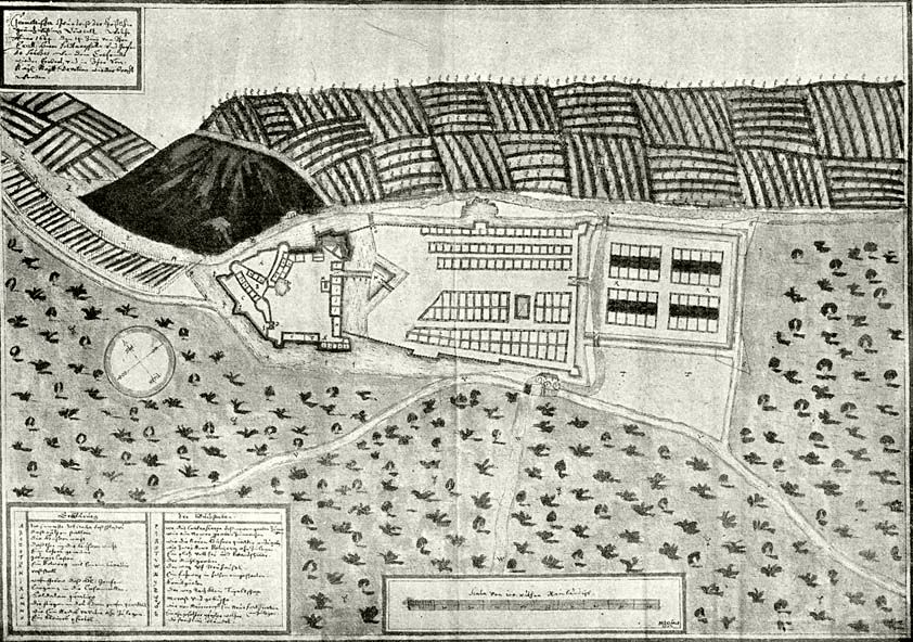
Austrian map, 1672
During the anti-Habsburg revolution of 1709, the fort was blown up by kuruces. After the break-up of Austria-Hungary, the town became a part of Czechoslovakia (confirmed by the Treaty of Trianon in 1920). As part of the breakup of Czechoslovakia under the Munich Agreement in World War II, the town again belonged to Hungary from 1938 to 1945. At the end of the Second World War it was returned to the restored Czechoslovakia, 75% of the town's Hungarian population was deported and replaced by Slovaks, rate of Hungarians fell from 89% to 12%. In 1993 it became part of present-day Slovakia.
It was the hometown of Eugene Fodor (1905–1991), the founder of Fodor's travel book company.
Demographics[]
Ethnicity (2001 census)[]
- Slovak (84.83%)
- Hungarian (12.23%)
- Czechs (1.04%)
- Romani (Gypsy) (0.36%)
- others.
Religious makeup[]
Roman Catholic (majority), Reformed Protestant (Calvinist), Moravian Brethren (the biggest congregation in Slovakia), Lutheran, Baptist, Old Catholic Church, Adventist of the 7th Day, Modrý kríž (Blue Cross), several Charismatic and Pentecostal communities, Jehovah's Witnesses, Muslim community (non-practising), Jewish community (non-practising), atheists
Economy[]
Production[]
Textiles, cosmetics, furniture, products from locally obtained Golden Onyx, machinery and construction components, cereals, meat, eggs, dairy products, soft drinks, malt, wine (Levická frankovka is a trademark for locally produced red-wine). One of Slovakia's two nuclear power plants is in Mochovce, 12 km north-west of Levice.
Education[]
There are 8 elementary schools (7 secular including 1 Hungarian, and 1 Roman Catholic school), a general High School, a Hungarian Calvinist High School (Lyceum), a Business Academy, a Pedagogical and Social Academy, a Secondary Technical School, a Secondary Agricultural School and various apprentice schools.
Main sights[]
- The Castle, built in a Gothic style as a trade-route guarding fort at the end of 13th century.
- Dobo Chateau, built by István Dobó, a hero of the siege of Eger, in the 1560s.


Levice castle, Slovakia, castle, aerial photography


Levice castle, Slovakia, castle, aerial photography
Places of worship[]


Church St.Michal
- St Joseph's Church, Roman Catholic, accompanied by a baroque Franciscan convent. It is found close to the entrance to the chateau, and dates from the turn of the 18th century.
- St Michael's Church - Roman Catholic, found in St Michael's street (Sv. Michala). It is from the 2nd half of the 18th century
- Church of the Holy Spirit - Roman Catholic, in the Rybniky quarter. It is from the start of the 21st century
- Chapel of St Urban - Roman Catholic, F. Hecku street, 1770s
- Evanjelický a. v. kostol - Lutheran, Cs. armady street, 1840s to 1930s
- Zborový dom (Congregational House) - Lutheran, next to the latter
- Kostol Reformovanej cirkvi - Calvinist, Sv. Michala street, end of 18th century
- Zborový dom (Congregational House) - Brethren Church, S. Chalupku street, 1983–85
- Synagogue - Jewish, K. Kittenberger street, half of 19th century
Other sights[]
- Schoeller's Mill - built at the end of the 19th century, production was cancelled in 1998, rebuilt into a complex of luxury shops, offices, dwellings and entertainment facilities.
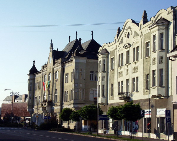
- Main square - a good collection of Art-Nouveau and eclectic buildings.
- Town hall - erected in 1902, second floor built-up while lifting the roof by a screw mechanism in 1927.
- Teachers Academy - secondary school, E point of the Kalvaria hill, N of the main square, built in 1911 as a mix of the late Art-Nouveau and Italian trecento-influenced historism.
Functionalist architectures[]
- District Court Building - corner of Mlynska and Zahradna streets, projected by Milan Michal Harminc
- Fried's House - corner of L. Stura and Sv. Michala streets
- Strasser's House - Sturova street, next to the Fried's House
- Fertsek Brothers House - corner of Soltesova square and Ceskoslovenskej armady street
- Munk's House - corner of Mlynska and Zahradna streets
- Reitmann's House - Mlynska street, a passage to I. Krasku street
- Eisler's House - corner of Mlynska and L. Stura streets
- Police District Headquarters Building - former Seat of District Authority, crossing of Kalvinske square and Sv. Michala street
- Health Ensurance Company Building - M. R. Stefanik street, later Infant Hospital
Nearby places of interest[]
- Horšianska Dolina (Horša Valley) - nature preserve with unique plant and animal endemics, folk architecture in Horša
- Kalinčiakovo - this village has a tiny but well preserved Romanesque church dating from the 12th century (see Romanesque church in Kalinčiakovo) and the swimming pool of Margita-Ilona
- Hronský Beňadik - medieval fort-monastery with Gothic entrance, tombs and memorabilia of Hungarian noblemen
- Želiezovce– Neoclassical residence of Count Eszterhazy, and Soví zámoček (Owl Chateau) where the Austrian composer Franz Schubert taught music
- Santovka– mineral water springs and swimming pool
- Brhlovce– cave-like dwellings cut into volcanic rock, nominated as a UNESCO World Heritage site
- Čajkov– known for local folk costumes and the annual wine harvest festival
- Pukanec– tiny mining town once enjoying the status of Free royal town, still known for hand-made pottery
- Sitno– volcanic peak in the Štiavnica Mountains, Celtic funeral place, medieval castle ruins, and a botanic nature reserve featuring rare rose species
Notable people[]
Levice is the birthplace of geographer Kálmán Kittenberger (1881–1958).
References[]
External links[]
- 360° panorama of jewish synagogue in Levice
- 360° panorama of Levice Castle
- Official town web site
- Map of Levice
- Levické internetové noviny Levičan.sk
| |||||||
| This page uses content from the English language Wikipedia. The original content was at Levice. The list of authors can be seen in the page history. As with this Familypedia wiki, the content of Wikipedia is available under the Creative Commons License. |