| Main | Births etc |
|---|
| Loos-en-Gohelle | |
|---|---|
 |
|

Loos-en-Gohelle | |
|
Location within Nord-Pas-de-Calais region

Loos-en-Gohelle |
|
| Coordinates: Coordinates: | |
| Country | France |
| Region | Hauts-de-France |
| Department | Pas-de-Calais |
| Arrondissement | Lens |
| Canton | Lens-Nord-Ouest |
| Intercommunality | Communaupole de Lens-Liévin |
| Government | |
| • Mayor (2008–2014) | Jean-François Caron (Green) |
| Area1 | 12.7 km2 (4.9 sq mi) |
| Population (2005)2 | 6,904 |
| • Density | 540/km2 (1,400/sq mi) |
| INSEE/Postal code | 62528 / 62750 |
| Elevation | 31–74 m (102–243 ft) (avg. 44 m or 144 ft) |
| 1 French Land Register data, which excludes lakes, ponds, glaciers > 1 km² (0.386 sq mi or 247 acres) and river estuaries. 2 Population without double counting: residents of multiple communes (e.g., students and military personnel) only counted once. | |
Loos-en-Gohelle is a commune in the Pas-de-Calais department in the Nord-Pas-de-Calais region of France.
Geography[]
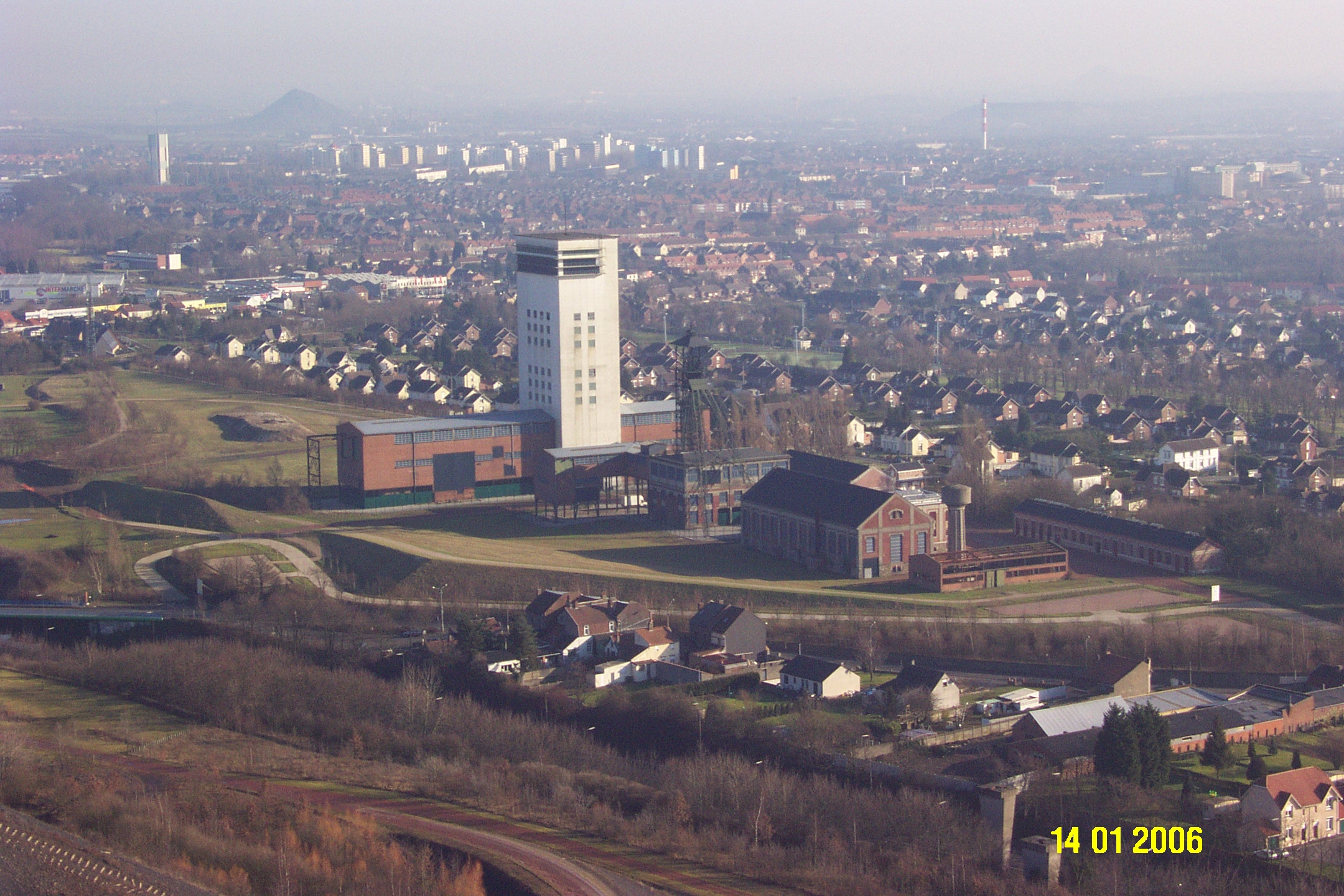
A former coal mining town, three miles northwest of the centre of Lens, at the junction of the D943 and the A21 autoroute. Its nearest neighbours are Lens to the south, Grenay to the west, Hulluch to the northeast and Bénifontaine to the east. The two largest (184m & 182m) spoil heaps in Europe are found here.


Slag heaps of pits 11 and 19 at Loos-en-Gohelle
History[]
The place was first documented in 1071, as "Lohes". The name has changed considerably over the years: Lothae, Lo, Lohes, Loes, Loez and Loos. It was not until 1791 that the name of "Loos" was officially sanctioned. According to some, the name comes from the Germanic "Lôh" and Dutch "Loo" which mean "wood", but there is no archaeological evidence of what could have been a forest. According to others, the name derives from the Germanic "Laupo" which means marshy meadows, which, given the topography of the town, tends to support this theory. In 1937, after much confusion with Loos-lez-Lille (today Loos), it was decided to add the region’s name (Gohelle) to that of the commune.
The oldest documents that specify the existence of Loos date from the eleventh century, at the time of construction of the abbey of Anchin. But with the foundation of a church dedicated to Saint Vaast, it suggests that the village existed long before (St. Vaast lived in the 6th century).
By the Middle Ages, Loos-en-Gohelle was a large village whose inhabitants lived mainly by farming: in 1569, 350 inhabitants, in 1759, 600 people ; In 1824, 700 inhabitants and in 1850 around 800 people.
It was around 1850 that the town started to become prosperous; farmers could fertilize previously uncultivated land, thanks to technology provided by Guislain Decrombecque and the discovery of coal resulted in a very rapid increase of population. Many monuments and cemeteries reflect the destruction during World War I which completely destroyed the town, particularly during the Battle of Loos, from the 25th September - 8 October 1915. At the end of the war, not a single building or tree had survived the pounding of artillery. Reminders of the war persist with the periodic discovery of unexploded ordnance.
The mining infrastructure, industry and transport were hit again during World War II.
In recent years, Loos has experienced another kind of destruction: that of the mining towns (about 1000 homes have been demolished in the recent past) as the population has left seeking work elsewhere. These tragedies could have removed Loos from the map of France, but each time, man has decided otherwise. Loos has been reborn 5 times, and is still undergoing transformation. Unfortunately nothing remains of the past.
Coal was mined here from 1855 until 1986. The very rural village changed into a town, with many foreign workers, especially from Poland, swelling the workforce. A former mining site (Écopole) has been preserved and now hosts many cultural, economic and environmental activities which are the symbol of new developments for the commune. Écopole 11/19 comprises buildings dating from 1923 and a modern concrete winding tower (height 66m) which operated from 1960 to 1986.
The landscape is still marked by enormous spoil heaps, those of pits 11 and 19, visible for miles around.
Nowadays, Loos-en-Gohelle is a town whose economy is dominated by light industry, textiles and workshops for artisans and professionals, but it also still retains a strong rural connection (there are thirty farms within the commune).
Population[]
| 1962 | 1968 | 1975 | 1982 | 1990 | 1999 | 2006 |
|---|---|---|---|---|---|---|
| 7522 | 7733 | 6958 | 6706 | 6561 | 6992 | 6904 |
| Census count starting from 1962: Population without duplicates | ||||||
Places of interest[]
- The church of St.Vaast, rebuilt, as was the rest of the town, after the First World War.
- The war memorials.
- Écopole 11/19
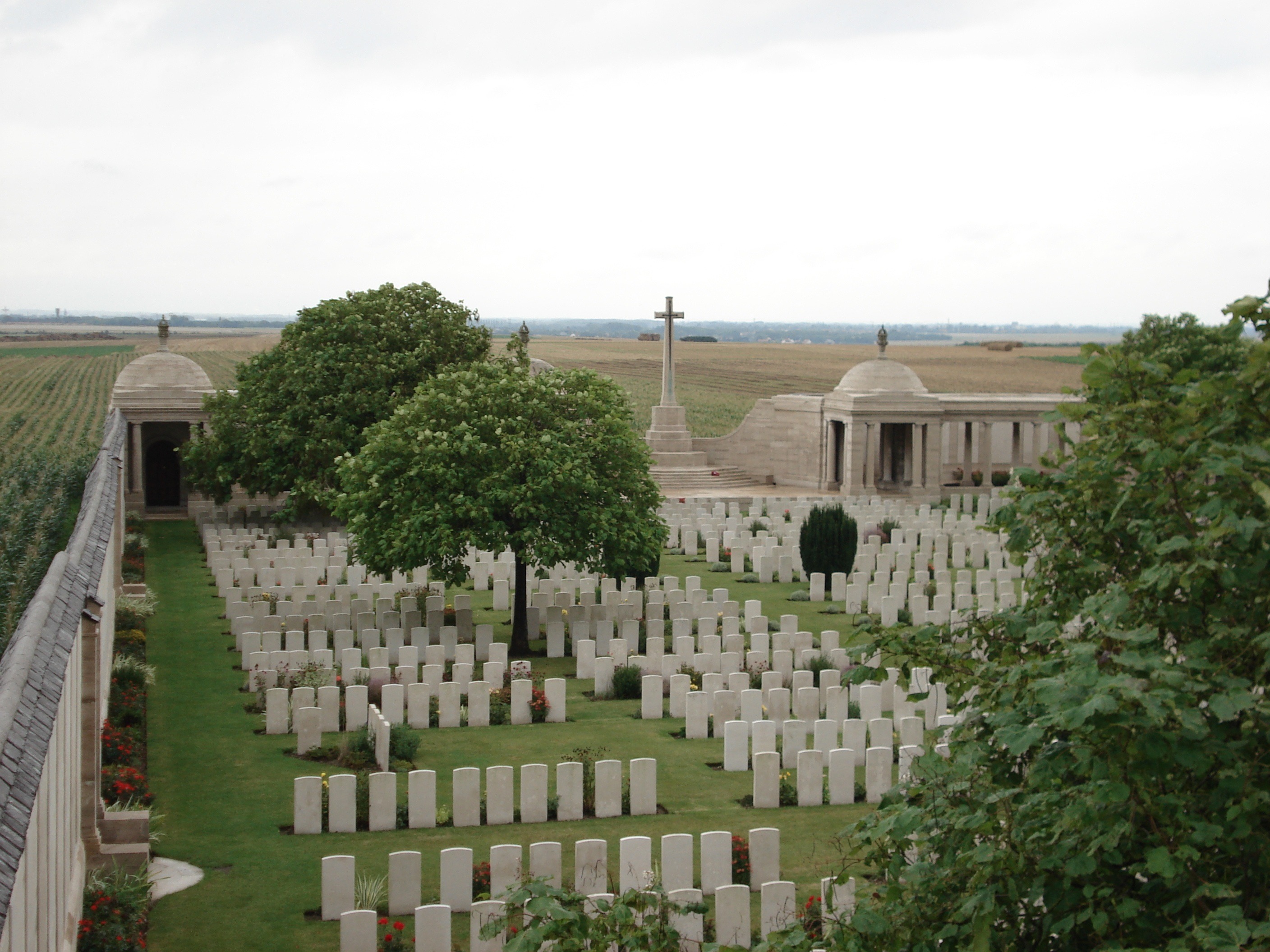
- The Commonwealth War Graves Commission cemeteries.

The Loos memorial at Dud Corner cemetery
See also[]
- Communes of the Pas-de-Calais department
References[]
External links[]
- Official Web site (French)
- Website of the Communaupole de Lens-Liévin (French)
- The Battle of Loos website
- The CWGC British cemetery
- The CWGC Dud Corner British cemetery
- Loos-en-Gohelle on the Quid website (French)
| |||||
| This page uses content from the English language Wikipedia. The original content was at Loos-en-Gohelle. The list of authors can be seen in the page history. As with this Familypedia wiki, the content of Wikipedia is available under the Creative Commons License. |