| Main | Births etc |
|---|
| Magyarbánhegyes | |||
|---|---|---|---|
| — Village (község) — | |||
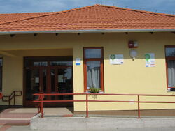
| Elementary school of Magyarbánhegyes | |||
|
|||
| Coordinates: | |||
| Country | |||
| Region | Southern Great Plain Region | ||
| County | |||
| Subregion | Mezőkovácsháza | ||
| Government | |||
| • Mayor | Mária Sódarné Varga Gyöngyi | ||
| Area | |||
| • Total | 36.56 km2 (14.12 sq mi) | ||
| Population (1 Jan. 2010) | |||
| • Total | 2,437 | ||
| • Density | 66.66/km2 (172.6/sq mi) | ||
| Time zone | CET (UTC+1) | ||
| • Summer (DST) | CEST (UTC+2) | ||
| Postal code | 5667 | ||
| Area code | 68 | ||
| ksh_code | 26028 | ||
| Website | [www.nagybanhegyes.hu] | ||
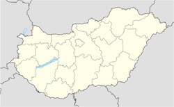
Magyarbánhegyes is a village in Békés County, in the Southern Great Plain Region of south-east Hungary.
Geography[]
It covers an area of 36.56 km² and has a population of 2437 people (2010).
| |||||||||||||||||
| This page uses content from the English language Wikipedia. The original content was at Magyarbánhegyes. The list of authors can be seen in the page history. As with this Familypedia wiki, the content of Wikipedia is available under the Creative Commons License. |


