Familypedia
Advertisement
Main-Tauber District
—  District  —
Wappen Main-Tauber-Kreis
Coat of arms
Lage Main-Tauber-Kreis in BW
Country Flag of Germany Germany
State Baden-Württemberg
Adm. region Stuttgart
Capital Tauberbischofsheim
Area
 • Total 1,304.51 km2 (503.67 sq mi)
Population (31 December 2010)[1]
 • Total 133,351
 • Density 100/km2 (260/sq mi)
Time zone CET (UTC+1)
 • Summer (DST) CEST (UTC+2)
Vehicle registration TBB
Website http://www.main-tauber-kreis.de

Main-Tauber District is a Kreis (district) in the north-east of Baden-Württemberg, Germany. Neighboring districts are (from north-west clockwise) Miltenberg, Main-Spessart, Würzburg, Neustadt an der Aisch-Bad Windsheim and Ansbach (all in Bavaria), and the districts of Schwäbisch Hall, Hohenlohe and Neckar-Odenwald.

History[]

The district was created in 1973 by merging the districts of Bad Mergentheim, Tauberbischofsheim and parts of the district of Buchen. At first it was called the district of Tauber, but in 1974 it was renamed to its current name, the district of Main-Tauber. The name comes from the two primary rivers in the district, the Main and the Tauber.

Geography[]

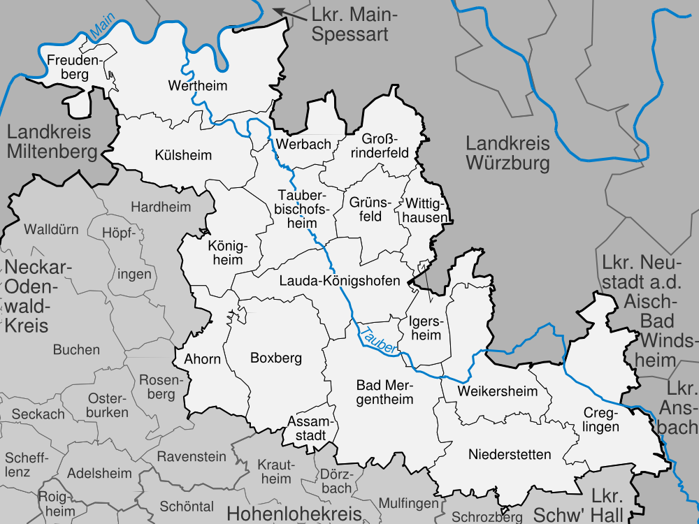
The Main forms the northern border of the district, while its affluent Tauber flows through the district from southeast to north. The north of the district covers part of the Spessart mountains, while the southern area is called Bauland.

Coat of arms[]

Coat of arms The coat of arms show the symbols of the three historical states to which the area of the district belonged. The biggest part of the district was part of the Bishopric of Würzburg until 1803; Würzburg is represented by the red and white field divided by a line with three peaks, which was originally the coat of arms of Franconia. The wheel is the symbol of the Archbishopric of Mainz; the cross is the symbol of the Teutonic Order.

Cities and municipalities[]

Karte Main-Tauber-Kreis

cities and towns in the district of Main-Tauber

Cities Administrative districts Municipalities
  1. Bad Mergentheim
  2. Boxberg
  3. Creglingen
  4. Freudenberg am Main
  5. Grünsfeld
  6. Külsheim
  7. Lauda-Königshofen
  8. Niederstetten
  9. Tauberbischofsheim
  10. Weikersheim
  11. Wertheim am Main
  1. Bad Mergentheim
  2. Boxberg
  3. Grünsfeld
  4. Tauberbischofsheim
  1. Ahorn
  2. Assamstadt
  3. Großrinderfeld
  4. Igersheim
  5. Königheim
  6. Werbach
  7. Wittighausen

References[]

  1. ^ "Bevölkerung und Erwerbstätigkeit" (in German). Statistisches Landesamt Baden-Württemberg. 31 December 2009. http://www.statistik-bw.de/Veroeffentl/Statistische_Berichte/3126_10001.pdf. 

External links[]

Wikimedia Community Logo

Coordinates: 49°34′N 9°43′E / 49.57, 9.71


This page uses content from the English language Wikipedia. The original content was at Main-Tauber District. The list of authors can be seen in the page history. As with this Familypedia wiki, the content of Wikipedia is available under the Creative Commons License.
Advertisement