| Masovian Voivodeship Województwo mazowieckie |
|||
|---|---|---|---|
| — Voivodeship — | |||
|
|||
 |
|||
 |
|||
| Coordinates (Warsaw): | |||
| Country | |||
| Capital | Warsaw | ||
| Counties | 5 cities, 37 land counties *
Ostrołęka
Płock Radom Siedlce Warsaw Białobrzegi County Ciechanów County Garwolin County Gostynin County Grodzisk Mazowiecki County Grójec County Kozienice County Legionowo County Lipsko County Łosice County Maków County Mińsk County Mława County Nowy Dwór Mazowiecki County Ostrołęka County Ostrów Mazowiecka County Otwock County Piaseczno County Płock County Płońsk County Pruszków County Przasnysz County Przysucha County Pułtusk County Radom County Siedlce County Sierpc County Sochaczew County Sokołów County Szydłowiec County Warsaw West County Węgrów County Wołomin County Wyszków County Żuromin County Zwoleń County Żyrardów County |
||
| Area | |||
| • Total | 35,579 km2 (13,737 sq mi) | ||
| Population (2006) | |||
| • Total | 5,164,612 | ||
| • Density | 150/km2 (380/sq mi) | ||
| • Urban | 3,343,231 | ||
| • Rural | 1,821,381 | ||
| Car plates | W | ||
| Website | http://www.mazovia.pl/ | ||
| * further divided into 314 gminas | |||


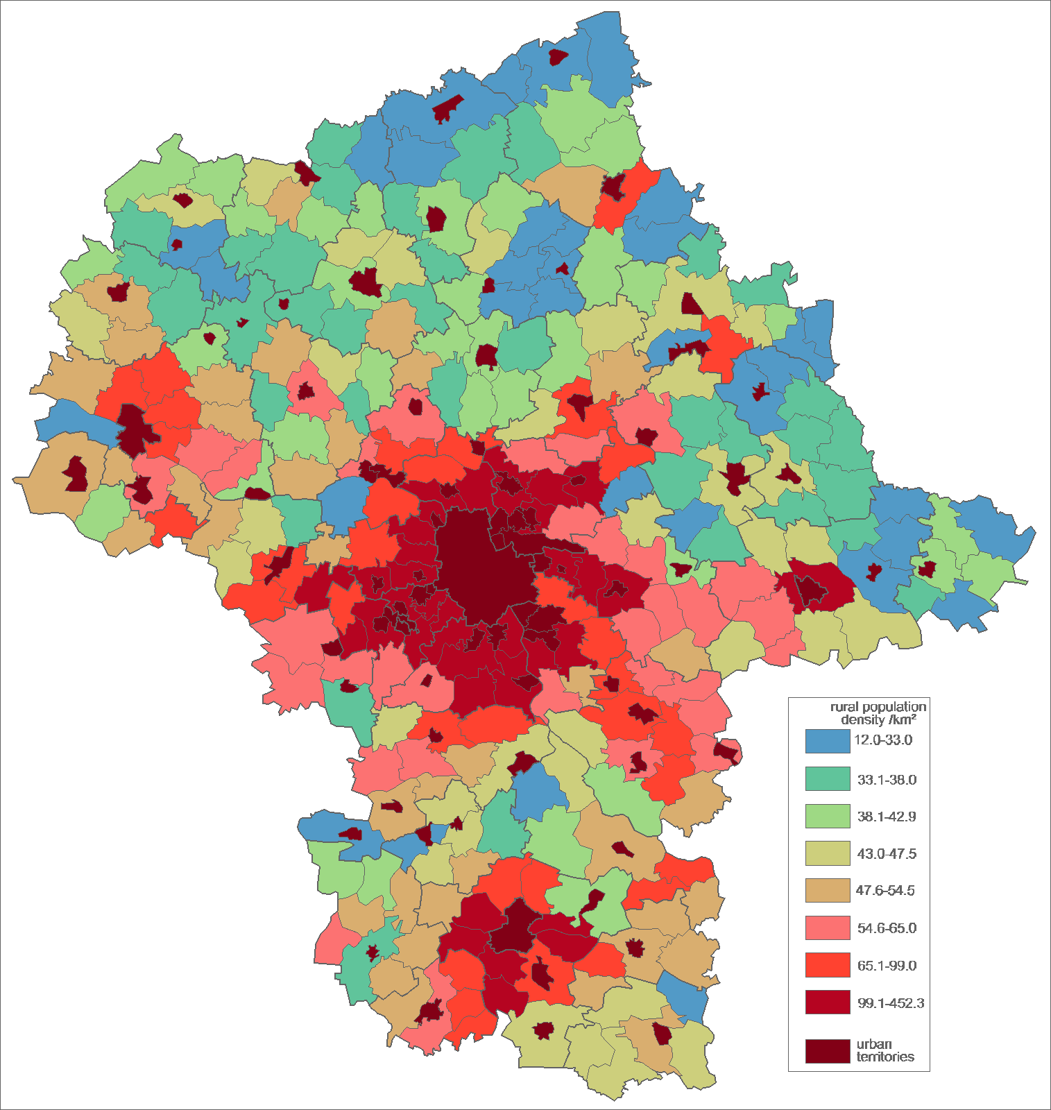
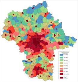
Rural population density by gmina (at 2007-01-01)
Masovian Voivodeship (Polish: województwo mazowieckie [vɔjɛˈvutstfɔ mazɔˈvjɛtskʲɛ]), is the largest and most populous of the sixteen Polish provinces, or voivodeships, created in 1999. It occupies 35,579 square kilometres (13,737 sq mi) of east-central Poland, and has 5.16 million inhabitants. Its principal cities are Warsaw (1.7 million) in the centre of the Warsaw metropolitan area, Radom (226,000) in the south, Płock (127,000) in the west, Siedlce (77,000) in the east, and Ostrołęka (55,000) in the north. The capital of the voivodeship is the national capital, Warsaw.
The province was created on January 1, 1999, out of the former Warsaw, Płock, Ciechanów, Ostrołęka, Siedlce and Radom Voivodeships, pursuant to the Polish local government reforms adopted in 1998. The province's name recalls the traditional name of the region, Mazowsze (sometimes rendered in English as "Masovia"), with which it is roughly coterminous. However, the southern part of the voivodeship, with Radom, historically belongs to Małopolska (Lesser Poland), while Łomża and its surroundings, even though historically part of Masovia, now is part of Podlaskie Voivodeship.
It is bordered by six other voivodeships: Warmian-Masurian to the north, Podlaskie to the north-east, Lublin to the south-east, Świętokrzyskie to the south, Łódź to the south-west, and Kuyavian-Pomeranian to the north-west.
Cities and towns[]
The voivodeship contains 85 cities and towns. These are listed below in descending order of population (according to official figures for 2006)[1]:
|
|
Administrative division[]
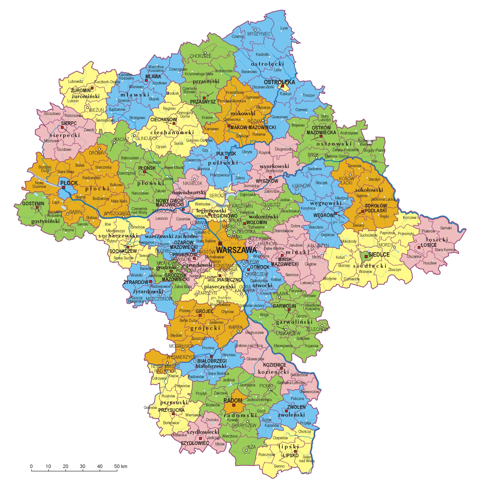
Masovian Voivodeship is divided into 42 counties (powiats): 5 city counties (miasto na prawach powiatu) and 37 "land counties" (powiat ziemski). These are subdivided into 314 gminas, which include 85 "urban gminas".
- The counties, shown on the numbered map, are described in the table below.
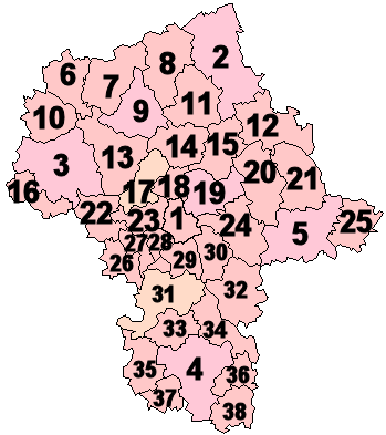
| |||||||
| Map ref. |
English and Polish names |
Area | Population (2006) |
Seat | Other towns | Total gminas | |
| (km²) | (sq mi) | ||||||
| City counties | |||||||
| 1 | Warsaw Warszawa |
517 | 200 | 1,700,536 | 1 | ||
| (2) | Ostrołęka | 29 | 11 | 53,758 | 1 | ||
| (3) | Płock | 88 | 34 | 127,307 | 1 | ||
| (4) | Radom | 112 | 43 | 226,372 | 1 | ||
| (5) | Siedlce | 32 | 12 | 77,047 | 1 | ||
| Land counties | |||||||
| 2 | Ostrołęka County powiat ostrołęcki |
2,099 | 810 | 84,344 | Ostrołęka * | Myszyniec | 11 |
| 3 | Płock County powiat płocki |
1,799 | 695 | 106,455 | Płock * | Gąbin, Drobin, Wyszogród | 15 |
| 4 | Radom County powiat radomski |
1,530 | 591 | 145,232 | Radom * | Pionki, Iłża, Skaryszew | 13 |
| 5 | Siedlce County powiat siedlecki |
1,603 | 619 | 80,560 | Siedlce * | Mordy | 13 |
| 6 | Żuromin County powiat żuromiński |
805 | 311 | 40,078 | Żuromin | Bieżuń | 6 |
| 7 | Mława County powiat mławski |
1,182 | 456 | 73,355 | Mława | 10 | |
| 8 | Przasnysz County powiat przasnyski |
1,218 | 470 | 52,948 | Przasnysz | Chorzele | 7 |
| 9 | Ciechanów County powiat ciechanowski |
1,063 | 410 | 91,050 | Ciechanów | Glinojeck | 9 |
| 10 | Sierpc County powiat sierpecki |
853 | 329 | 53,811 | Sierpc | 7 | |
| 11 | Maków County powiat makowski |
1,065 | 411 | 46,474 | Maków Mazowiecki | Różan | 10 |
| 12 | Ostrów Mazowiecka County powiat ostrowski |
1,218 | 470 | 75,073 | Ostrów Mazowiecka | Brok | 11 |
| 13 | Płońsk County powiat płoński |
1,384 | 534 | 87,430 | Płońsk | Raciąż | 12 |
| 14 | Pułtusk County powiat pułtuski |
829 | 320 | 51,033 | Pułtusk | 7 | |
| 15 | Wyszków County powiat wyszkowski |
876 | 338 | 71,558 | Wyszków | 6 | |
| 16 | Gostynin County powiat gostyniński |
616 | 238 | 47,034 | Gostynin | 5 | |
| 17 | Nowy Dwór Mazowiecki County powiat nowodworski |
692 | 267 | 75,736 | Nowy Dwór Mazowiecki | Nasielsk, Zakroczym | 6 |
| 18 | Legionowo County powiat legionowski |
390 | 151 | 96,497 | Legionowo | Serock | 5 |
| 19 | Wołomin County powiat wołomiński |
955 | 369 | 202,444 | Wołomin | Ząbki, Marki, Kobyłka, Zielonka, Radzymin, Tłuszcz | 12 |
| 20 | Węgrów County powiat węgrowski |
1,219 | 471 | 67,823 | Węgrów | Łochów | 9 |
| 21 | Sokołów County powiat sokołowski |
1,131 | 437 | 56,823 | Sokołów Podlaski | Kosów Lacki | 9 |
| 22 | Sochaczew County powiat sochaczewski |
731 | 282 | 83,318 | Sochaczew | 8 | |
| 23 | Warsaw West County powiat warszawski zachodni |
533 | 206 | 100,965 | Ożarów Mazowiecki | Łomianki, Błonie | 7 |
| 24 | Mińsk County powiat miński |
1,164 | 449 | 141,048 | Mińsk Mazowiecki | Sulejówek, Halinów, Kałuszyn | 13 |
| 25 | Łosice County powiat łosicki |
772 | 298 | 32,769 | Łosice | 6 | |
| 26 | Żyrardów County powiat żyrardowski |
533 | 206 | 74,662 | Żyrardów | Mszczonów | 5 |
| 27 | Grodzisk Mazowiecki County powiat grodziski |
367 | 142 | 78,208 | Grodzisk Mazowiecki | Milanówek, Podkowa Leśna | 6 |
| 28 | Pruszków County powiat pruszkowski |
246 | 95 | 145,870 | Pruszków | Piastów, Brwinów | 6 |
| 29 | Piaseczno County powiat piaseczyński |
621 | 240 | 145,276 | Piaseczno | Konstancin-Jeziorna, Góra Kalwaria, Tarczyn | 6 |
| 30 | Otwock County powiat otwocki |
615 | 237 | 116,086 | Otwock | Józefów, Karczew | 8 |
| 31 | Grójec County powiat grójecki |
1,269 | 490 | 96,489 | Grójec | Warka, Nowe Miasto nad Pilicą, Mogielnica | 10 |
| 32 | Garwolin County powiat garwoliński |
1,284 | 496 | 106,227 | Garwolin | Łaskarzew, Pilawa, Żelechów | 14 |
| 33 | Białobrzegi County powiat białobrzeski |
639 | 247 | 33,545 | Białobrzegi | Wyśmierzyce | 6 |
| 34 | Kozienice County powiat kozienicki |
917 | 354 | 61,614 | Kozienice | 7 | |
| 35 | Przysucha County powiat przysuski |
801 | 309 | 43,822 | Przysucha | 8 | |
| 36 | Zwoleń County powiat zwoleński |
571 | 220 | 37,183 | Zwoleń | 5 | |
| 37 | Szydłowiec County powiat szydłowiecki |
452 | 175 | 40,083 | Szydłowiec | 5 | |
| 38 | Lipsko County powiat lipski |
748 | 289 | 36,669 | Lipsko | 6 | |
| * seat not part of the county | |||||||
Protected areas[]
Protected areas in Masovian Voivodeship include one National Park and nine Landscape Parks. These are listed below.
- Kampinos National Park (a UNESCO-designated biosphere reserve)
- Bolimów Landscape Park (partly in Łódź Voivodeship)
- Brudzeń Landscape Park
- Bug Landscape Park
- Chojnów Landscape Park
- Górzno-Lidzbark Landscape Park (partly in Kuyavian-Pomeranian and Warmian-Masurian Voivodeships)
- Gostynin-Włocławek Landscape Park (partly in Kuyavian-Pomeranian Voivodeship)
- Kozienice Landscape Park
- Masovian Landscape Park
- Podlaskie Bug Gorge Landscape Park (partly in Lublin Voivodeship)
Most popular surnames in the region[]
- Kowalski: 26,270
- Wiśniewski: 21,940
- Kowalczyk: 21,586
- Mazurkiewicz: Founding of Masovia Name.
Historical[]
Masovian Voivodeship (1526–1795)[]
- For more details on this topic, see Masovian Voivodeship (1526–1795).
Masovia Voivodeship, 1526–1795 (Polish: Województwo Mazowieckie) was an administrative region of the Kingdom of Poland, and of the Polish-Lithuanian Commonwealth, from the 15th century until the partitions of the Polish-Lithuanian Commonwealth (1795). Together with Płock and Rawa Voivodeships, it formed the province (prowincja) of Masovia.
Masovian Voivodeship (1816–1837)[]
Masovian Voivodeship was one of the voivodeships of Congress Poland. It was formed from Warsaw Department, and transformed into Masovia Governorate.
Transport[]
There are three main road routes that pass through the voivodship: Cork-Berlin-Poznań-Warszawa-Minsk-Moscow-Omsk, Prague-Wrocław-Warsaw-Białystok-Helsinki and Pskov-Gdańsk-Warsaw-Kraków-Budapest.
Currently there are only small stretches of freeway in the area. However, upon completion the A2 freeway will be the first freeway to connect the region, and therefore the capital city, with the rest Europe. The freeway will pass directly through the voivodship from east to west connecting it with Belarus and Germany.
The railroad system is based on Koleje Mazowieckie and PKP Intercity.
The main international airport in the region is Warsaw Frederic Chopin Airport.
Economy[]
Due to it's central location and the fact that it contains the capital city of Warsaw, the Masovian Voivodeship is the wealthiest in Poland in terms of GDP per capita. In 2008 it stood at 22,200 Euro (PPP), which is 89% of EU27 average.
See also[]
- Second Polish Republic's Warsaw Voivodeship (1919–1939)
References[]
External links[]
- Mazowiecki Urząd Marszałkowski Official website
| ||||||||||
| This page uses content from the English language Wikipedia. The original content was at Masovian Voivodeship. The list of authors can be seen in the page history. As with this Familypedia wiki, the content of Wikipedia is available under the Creative Commons License. |