The Commonwealth of Massachusetts (English pronunciation: /ˌmæ.səˈtʃu.sɪts/) is a state in the New England region of the northeastern United States. Most of its population of 6.4 million live in the Boston metropolitan area. The eastern half of this relatively small state is mostly urban and suburban. The west is primarily rural; however, most of its population actually lives in urban enclaves. Massachusetts is the most populous of the six New England states and ranks third in overall population density among the 50 states.
The first Europeans to settle New England landed in present-day Massachusetts. These settlers were Pilgrims and Puritans from England seeking religious freedom. They founded Plymouth, Salem, and Boston, which soon became the hub of the region, then the Pioneer Valley along the Connecticut River where the state's best agricultural land was concentrated. A century and a half later, Massachusetts became known as the 'Cradle of Liberty' for the revolutionary ferment in Boston that helped spawn the war of the Thirteen Colonies for independence.
During the 19th century, Massachusetts transformed itself from a mainly agricultural economy to a manufacturing one, making use of its many rivers for power to operate factories for shoes, furniture, and clothing that drew labor from Yankees on unproductive subsistence farms at first, then turned to immigrant labor from Europe. The industrial economy declined in the early twentieth century when industry moved south in search of cheaper labor. A revitalization came in the 1970s when, nourished by the graduates of the area's many elite institutions of higher education, the Boston suburbs (particularly those near Route 128) became home to dozens of high-technology companies. Massachusetts's colleges and universities, as well as its technology sectors, continue to thrive.
Massachusetts has been one of the most influential states in America. The first battles of the American Revolution were fought in the Massachusetts towns of Concord and Lexington. The Boston Tea Party is a well-known example of the revolutionary spirit of those times. In the 19th century, the state became a bastion of social progressivism and a birthplace of the abolitionist movement that emancipated southern blacks from slavery. The Kennedy family dominated Massachusetts politics in the 20th century. In the 21st century, the state continues to lead the country in social and cultural change, and in 2003 became the first state in the union to allow same-sex couples to marry.
Name
The Massachusetts Bay Colony was named after the indigenous population, the Massachusett, whose name can be segmented as mass-adchu-s-et, where mass- is "large", -adchu- is "hill", -s- is a diminutive suffix meaning "small", and -et is a locative suffix, identifying a place. It has been translated as "at the great hill," "at the little big hill," or "at the range of hills," referring to the Blue Hills, or in particular, Great Blue Hill, located on the boundary of Milton and Canton, to the southwest of Boston.[1][2][3] (c.f. the Narragansett name Massachusêuck;[2] Ojibwe misajiwensed, "of the little big hill").[4]
Massachusetts is officially a "commonwealth." Colloquially, it is often referred to simply as "the Commonwealth," although "state" is used interchangeably. While this designation is part of the state's official name, it has no practical implications. Massachusetts has the same position and powers within the United States as other states and a similar form of internal government.
Geography
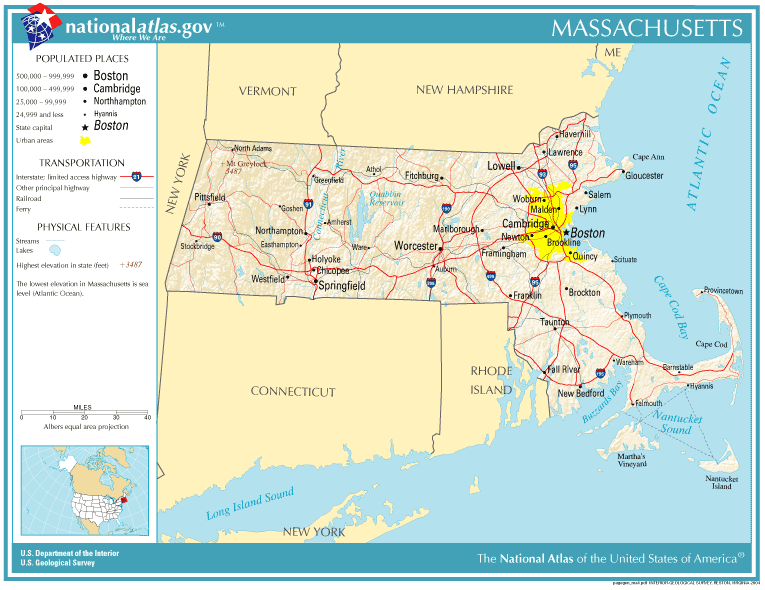
Prominent roads and cities in Massachusetts
Massachusetts is bordered on the north by New Hampshire and Vermont; on the west by New York; on the south by Connecticut and Rhode Island; and on the east by the Atlantic Ocean. Most of the state is uplands of resistant metamorphic rock that were scraped by Pleistocene glaciers that deposited moraines and outwash on large, sandy, arm-shaped peninsula called Cape Cod and the islands Martha's Vineyard and Nantucket to the south of Cape Cod. Upland elevations increase to the north and west and the highest point in the state is Mount Greylock at 3491 feet near the state's northwest corner.
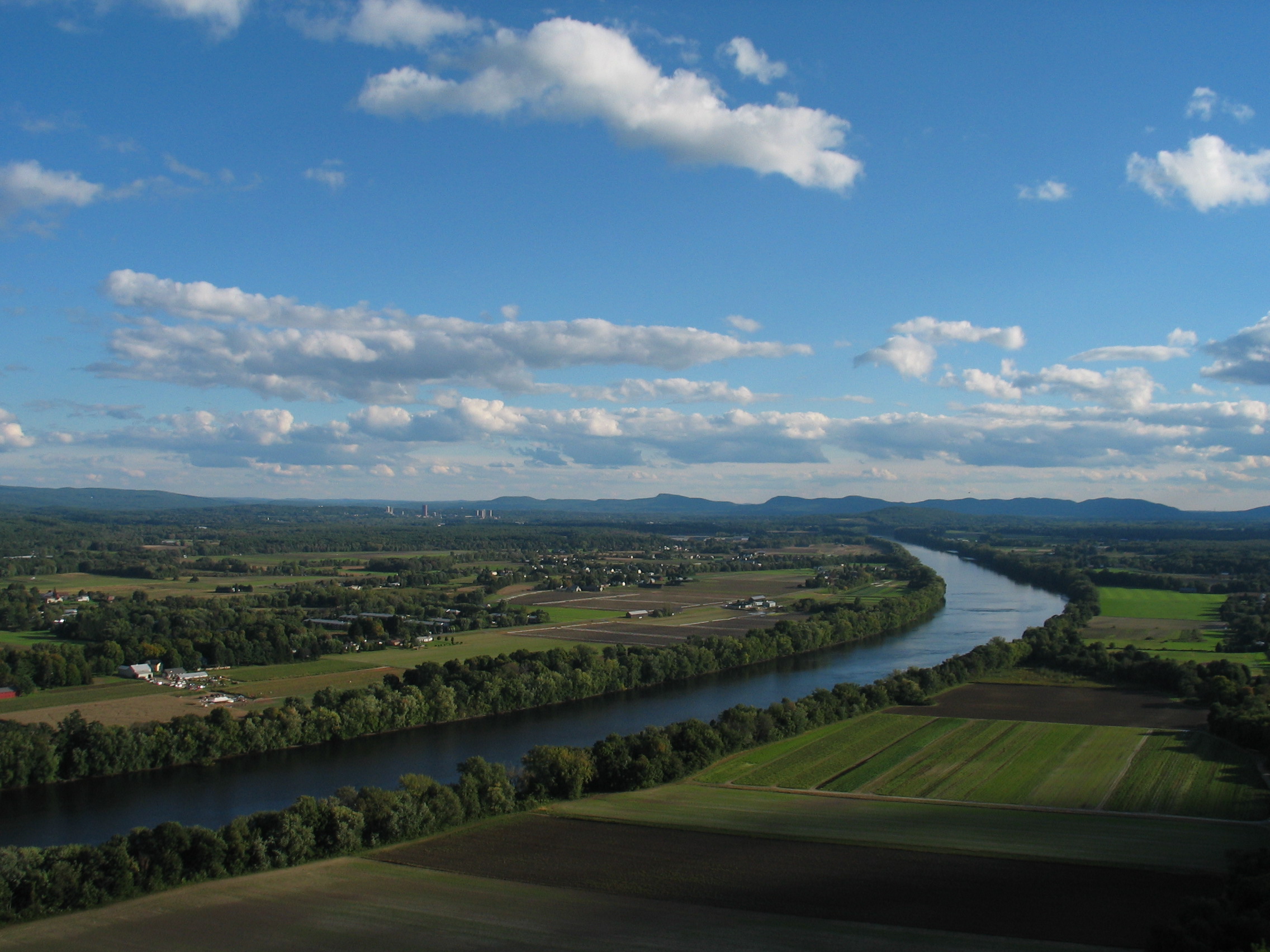
A portion of the north-central Pioneer Valley near South Deerfield, much more rural than Springfield, in the southern part of the valley, or Boston, which is on the coast.
The uplands are interrupted by the downfaulted Pioneer Valley along the Connecticut River and further west by the Housatonic Valley separating the Berkshire Hills from the Taconic Range along the western border with New York.
Boston is located at the innermost point of Massachusetts Bay, at the mouth of the Charles River, the longest river entirely within Massachusetts. Most of the population of the Boston metropolitan area (approximately 4.4 million) does not live in the city proper; eastern Massachusetts on the whole is fairly densely populated and largely suburban as far west as Worcester.
Central Massachusetts between Worcester and the Pioneer Valley is an upland region of small towns, forests, and small farms. It includes Quabbin Reservoir, the main water supply for the eastern part of the state, and its protected watershed. The entire region has recently acquired a strong identity. It includes many small towns and cities: Athol, Erving, Holden, Princeton, Gardner, Hardwick, New Salem, Orange, Petersham, Phillipston, Royalston, Warwick and Wendell. Every inch of land in Massachusetts is part of a town or city; there is no unincorporated county land. The North Quabbin Woods (www.northquabbinwoods.org) maintains a web site featuring one of these regions.Massachusetts Cities and TownsPDF (390 KiB) (map; see text on map). Secretary of the Commonwealth of Massachusetts. Retrieved January 14, 2007.</ref>
The "Pioneer Valley" along the Connecticut River in Western Massachusetts is also urbanized from the Connecticut border (where it adjoins greater Hartford north as far as Northampton, including Springfield, West Springfield, Westfield, and Holyoke. Pioneer Valley urbanization was driven by productive agriculture in the 17th and 18th century, water power for the Industrial Revolution in the 19th century and expansion of higher education in the 20th century.
The remainder of the state west of Pioneer Valley is mainly uplands, a range of small mountains known as the Berkshires, summer home to the Boston Symphony Orchestra (Lenox), Jacob's Pillow Dance Festival, the Norman Rockwell Museum (Stockbridge), Monument Mountain, where Nathaniel Hawthorne and Herman Melville had a fateful meeting, and Mount Greylock, the hightest point in Massachusetts. It largely remained in aboriginal hands until the 18th century when Scotch-Irish settlers arrived and found the more productive lands already settled. Availability of better land in western New York and then the Northwest Territories soon put the upland agricultural population into decline, but the Industrial Revolution made growing use of water power, leading to 19th century settlement along upland rivers. Pittsfield and North Adams grew into small cities and there are a number of smaller mill towns along the Westfield River.
The geographic center of the state is in the town of Rutland, in Worcester county. The National Park Service administers a number of natural and historical sites in Massachusetts
The fourteen counties, moving roughly from west to east, are Berkshire, Franklin, Hampshire, Hampden, Worcester, Middlesex, Essex, Suffolk, Norfolk, Bristol, Plymouth, Barnstable, Dukes, and Nantucket. Because of the state's historical ties to England, all but two of the Commonwealth's fourteen counties are named for British counties, cities, or nobles.
Climate
Massachusetts has a humid continental climate, with warm summers and cold, snowy winters. With its proximity to the Atlantic Ocean, Massachusetts receives a generous amount of precipitation throughout the year, but is slightly wetter during the winter. Summers are warm with average high temperatures in July above 80 °F and overnight lows above 60 ° common throughout the state. Winters are cold, but generally less extreme on the coast with high temperatures in the winter averaging above freezing even in January, although areas further inland are much colder.
Flora and fauna
The primary biome of inland Massachusetts is temperate deciduous forest. However, much of the state has been logged, leaving only traces of old growth forest in isolated pockets. Secondary growth has regenerated in many woodlots and forests, particularly in the western half of Massachusetts. Urbanization, particularly in the eastern half of the state, has affected much of Massachusetts. No longer are there vast expanses of wilderness. Gray Wolf, Elk, Wolverine and Mountain Lion once occurred here but have long since disappeared.
Massachusetts has an extensive coastline and enjoys a strong commercial fishery out to the continental shelf. Atlantic cod, haddock and American lobster are species harvested here.
History

Mayflower in Plymouth Harbor by William Halsall (1882)
Massachusetts was originally inhabited by several Algonquian tribes: the Wampanoag, Nauset, Nipmuc, Pocomtuc, Pennacook, Mahican, and some Narragansett and Pequot. These indigenous people were decimated by waves of smallpox inadvertently brought to the New World by Sir Herbert Popham and his ship to the Saco Maine area in 1616.
The first European settlers in Massachusetts, the Pilgrims, established their settlement at Plymouth in 1620, and developed friendly relations with the native Wampanoag. Most early settlers came from within 60 miles of Haverhill, England. The Pilgrims were soon followed by Puritans who established the Massachusetts Bay Colony at present-day Boston. The Puritans, whose beliefs included exclusive understanding of the literal truth of the Bible, came to Massachusetts for religious freedom. Dissenters such as Anne Hutchinson, Roger Williams, and Thomas Hooker left Massachusetts because of the Puritan society's lack of religious tolerance. Williams founded the colony of Rhode Island, and Hooker founded Connecticut.
Native American-European racial tensions led to King Philip's War 1675-76. There were major campaigns in the Pioneer Valley and Plymouth Colony, as well as an unsuccessful expedition against Quebec under William Phips in 1690. Massachusetts became a single colony in 1692, the largest in New England, and one where many American institutions and traditions were formed. The colony fought alongside British regulars in a series of French and Indian Wars that were characterized by brutal border raids and successful attacks on British forces in New France (present-day Canada).

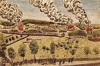
Percy's Rescue at Lexington by Ralph Earl and Amos Doolittle from 1775.
Massachusetts was a center of the movement for independence from Great Britain. With actions by patriots such as Sam Adams and John Hancock followed by counter-actions by the Crown were a main reason for the unity of the Thirteen Colonies and the outbreak of the American Revolution, starting with battles in and around Boston in 1775-76. After independence and during the formative years of independent American government, Shays' Rebellion was an armed uprising in the western half of the state from 1786 to 1787. The rebels were mostly small farmers angered by crushing war debt and taxes which resulted from their lack of representation in congress. Massachusetts was the first U.S. state to abolish slavery, in a 1783 judicial interpretation of its 1780 constitution.
On March 15, 1820, Maine separated from Massachusetts, of which it had been a non-contiguous part, and entered the Union as the 23rd State as a result of the ratification of the Missouri Compromise. Massachusetts became a national and world leader in industrialization, with its mastery of machine tools and textiles. Horace Mann made the state system of schools the national model. Henry David Thoreau and Ralph Waldo Emerson made major contributions to American thought. Members of the Trancendentalism movement, they emphasized the importance of the natural world to humanity.
In the years leading up to the Civil War, Massachusetts was a center of temperance and abolitionist activity within the United States. Antagonism to their views resulted in anti-abolitionist riots in Massachusetts between 1835 and 1837. The works of abolitionists contributed to subsequent actions of the state during the Civil War. Massachusetts was the first state to recruit, train, and arm a black regiment with white officers, the 54th Massachusetts Volunteer Infantry.
Massachusetts entered the twentieth century with a strong industrial economy, but by the 1920s low-wage competition from the South, followed by the Great Depression, led to the collapse of Massachusetts’ two main industries, shoes and textiles. In the years following World War II, Massachusetts was transformed from a factory system to a largely service and high-tech based economy. In the ensuing years, government contracts, private investment, and research facilities led to a new and improved industrial climate, with reduced unemployment and increased per capita income. Suburbanization flourished, as the Route 128 corridor became dotted with research developments. In 1987 the state received federal funding for the $14.6 billion Central Artery/Tunnel Project. Known colloquially as the "the Big Dig," it was at the time the biggest federal highway project ever approved.
Demographics
Population
| Historical populations | |||
|---|---|---|---|
| Census | Pop. | %± | |
| 1790 | 378,787 | ||
| 1800 | 422,845 | 11.6% | |
| 1810 | 472,040 | 11.6% | |
| 1820 | 523,287 | 10.9% | |
| 1830 | 610,408 | 16.6% | |
| 1840 | 737,699 | 20.9% | |
| 1850 | 994,514 | 34.8% | |
| 1860 | 1,231,066 | 23.8% | |
| 1870 | 1,457,351 | 18.4% | |
| 1880 | 1,783,085 | 22.4% | |
| 1890 | 2,238,947 | 25.6% | |
| 1900 | 2,805,346 | 25.3% | |
| 1910 | 3,366,416 | 20.0% | |
| 1920 | 3,852,356 | 14.4% | |
| 1930 | 4,249,614 | 10.3% | |
| 1940 | 4,316,721 | 1.6% | |
| 1950 | 4,690,514 | 8.7% | |
| 1960 | 5,148,578 | 9.8% | |
| 1970 | 5,689,170 | 10.5% | |
| 1980 | 5,737,037 | 0.8% | |
| 1990 | 6,016,425 | 4.9% | |
| 2000 | 6,349,097 | 5.5% | |
| Sources:[5][6] | |||
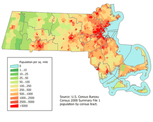
Most Bay Staters live within a sixty-mile radius of the State House on Beacon Hill, often called Greater Boston: the City of Boston, neighboring cities and towns, the North Shore, South Shore, the northern, western, and southern suburbs, and most of southeastern and central Massachusetts. The 40-mile corridor between Boston and Worcester is called "Massachusetts Main Street." Eastern Massachusetts is more urban than Western Massachusetts, which is primarily rural, save for the cities of Springfield, and Northampton, which serve as centers of population density in the Pioneer Valley of the Connecticut River. The center of population of Massachusetts is located in Middlesex County, in the town of Natick.[7]

Massachusetts Population Density Map
Although most of the Native Americans intermarried or died in King Philip's War (1675), the Wampanoag tribe maintains reservations at Aquinnah, Grafton, on Martha's Vineyard, and Mashpee.[8][9] The Nipmuck maintain two state-recognized reservations in the central part of the state. Other Wampanoags and other Native people live scattered around the state outside of reservations.
Religion
Massachusetts was founded and settled by staunch Puritans in the 17th century. The descendants of the Puritans belong to many different churches; in the direct line of inheritance are the Congregational/United Church of Christ and Unitarian Universalist churches. Both of these denominations are noted for their strong support of social justice, civil rights, and moral issues, including strong and early advocacy of abolition of slavery, women's rights, and (after 2000) legal recognition of gay marriage. The world headquarters of the Unitarian-Universalist Church is located on Beacon Hill in Boston. Today Protestants make up less than 1/3 of the state's population. Roman Catholics now predominate because of massive immigration from Ireland, Quebec, Italy, Poland, Portugal, Puerto Rico, and the Dominican Republic. A large Jewish population came to the Boston area 1880-1920. Mary Baker Eddy made the Boston Mother Church of Christian Science the world headquarters.
Emigration and Immigration
The latest estimated 2006 population Census figures show that Massachusetts has grown by slightly over 1 percent, to 6,437,193, since 2000. This growth is attributable to the fact that Massachusetts continues to attract top scholars and researchers as well as immigrants.
High housing costs, taxes, weather, and traffic in Massachusetts have contributed to emigration to the Boston exburbs, to neighboring New Hampshire and Rhode Island, and to Southern and Western regions of the United States.
Law, government and politics
State House (Boston)
Law
The Massachusetts Constitution was ratified in 1780 while the Revolutionary War was in progress, four years after the Articles of Confederation was drafted, and seven years before the present United States Constitution was ratified in 1787. Massachusetts has the oldest written Constitution now in use by any government in the world. It specifies three branches of government: executive, legislative, and judicial.
Government
The governor is head of the executive branch and serves as chief administrative officer of the state and as commander-in-chief of the Massachusetts National Guard.
The Massachusetts state legislature is formally styled the "General Court." (See Massachusetts General Court) Elected every two years, the General Court is made up of a Senate of 40 members and a House of Representatives of 160 members. The Massachusetts Senate is said to be the second oldest democratic deliberative body in the world.[10] Each branch elects its own leader from its membership. The Senate elects its president; the House its speaker. These officers exercise power through their appointments of majority floor leaders and whips (the minority party elects its leaders in a party caucus), their selection of chairs and all members of joint committees, and in their rulings as presiding officers. Joint committees of the General Court are made up of 6 senators and 15 representatives, with a Senate and House chair for each committee. These committees must hold hearings on all bills filed. Their report usually determines whether or not a bill will pass. Each chamber has its own Rules Committee and Ways and Means Committee and these are among the most important committee assignments.
Judicial appointments are held to the age of seventy. The Supreme Judicial Court, consisting of a chief justice and six associate justices, is the highest court in the Commonwealth; it is empowered to give advisory opinions to the governor and the legislature on questions of law. All trials are held in departments and divisions of a unified Trial Court, headed by a Chief Justice for Administrative and Management, assisted by an administrator of courts. It hears civil and criminal cases. Cases may be appealed to the Supreme Judicial Court or the Appeals Court for review of law, but findings of fact made by the Trial Court are final. The Superior Court, consisting of a chief justice and sixty-six associate justices, is the highest department of the Trial Court. Other departments are the District, Housing, Juvenile, Land, and Probate Courts.
Massachusetts's U.S. senators are Edward Kennedy (D) and John Kerry (D). The 10 Members of the states delegation to the U.S. House of Representatives are John Olver (D), Richard Neal (D), Jim McGovern (D), Barney Frank (D), Marty Meehan (D), John F. Tierney (D), Ed Markey (D), Mike Capuano (D), Stephen Lynch (D), and Bill Delahunt (D). Federal court cases are heard in the United States District Court for the District of Massachusetts. Appeals are heard by the United States Court of Appeals for the First Circuit.
Politics
During the first half of the 1900s, Boston was socially conservative and strongly under the influence of Methodist minister J. Frank Chase and his New England Watch and Ward Society, founded in 1878. In 1903, the Old Corner Bookstore was raided and fined for selling Boccaccio's Decameron.
Cities and towns
There are 50 cities and 301 towns in Massachusetts, grouped into 14 counties.[11] Eleven communities which call themselves "towns" are, by law, cities since they have traded the town meeting form of government for a mayor-council or manager-council form.[12] Boston is the state capital and largest city. It is the nation's 11th largest metropolitan area. Cities over 100,000 in population (2004 estimates) include Boston, Worcester, Springfield, Lowell, and Cambridge. Massachusetts shares the governmental structure known as the New England town with the five other New England states, as well as New York and New Jersey.
Education
Massachusetts has historically had a strong commitment to education. It was the first state to require municipalities to appoint a teacher or establish a grammar school (albeit paid by the parents of the pupils) with the passage of the Massachusetts Education Law of 1647; this mandate was later made a part of the state constitution in 1789. The town of Rehoboth, Massachusetts has been noted to be the birthplace of public education in North America. Massachusetts is home to the country's oldest high school, Boston Latin School (founded 1635), America's first publicly funded high school, Dedham, Massachusetts (founded 1643), oldest college, now called Harvard University (founded 1636), and oldest municipally supported free library, Boston Public Library (founded 1848). Massachusetts was the first state to pass compulsory school attendance laws (1852)[13]
Media
The Boston Globe, Boston Herald, Worcester Telegram & Gazette and the Springfield Republican are the Commonwealth's largest daily newspapers. In addition, there are many community dailies and weeklies found throughout the state. There are a number of major radio stations (AM 50,000 watts, FM over 20,000 watts) which service Massachusetts, along with many more regional and community based stations. Some colleges and universities also operate campus television and radio stations, and print their own newspaper.
See also
- List of Massachusetts county seats
- List of people from Massachusetts
- List of official symbols of Massachusetts
- Massachusetts census statistical areas
- Massachusetts State Police
- List of Massachusetts Area Codes
References
- ^ This derivation is located in C. Lawrence Bond, Native Names of New England Towns and Villages, privately published, Topsfield, Massachusetts, 1991. The pamphlet was never mass produced but it is probably obtainable through the library or bookstores in Topsfield.
- ^ a b Salwen, Bert, 1978. Indians of Southern New England and Long Island: Early Period. In "Northeast", ed. Bruce G. Trigger. Vol. 15 of "Handbook of North American Indians", ed. William C. Sturtevant, pp. 160-176. Washington D.C.: Smithsonian Institution. Quoted in: Campbell, Lyle. 1997. American Indian Languages: The Historical Linguistics of Native America. Oxford: Oxford University Press, pg. 401
- ^ Bright, William (2004). Native American Place Names of the United States. Norman: University of Oklahoma Press, pg. 270
- ^ "Freelang Ojibwe Dictionary". Freelang.net. http://www.freelang.net/dictionary/ojibwe.html.
- ^ Population: 1790 to 1990PDF (35.4 KiB) census.gov
- ^ Resident Population of the 50 States, the District of Columbia, and Puerto Rico: Census 2000 census.gov
- ^ Population and Population Centers by State: 2000. United States Census Bureau, United States Deparatment of Commerce. Retrieved January 14, 2007.
- ^ Associated Press. Wampanoag Tribe Receives Federal Recognition WBZ-TV, Boston Massachusetts. Retrieved February 20, 2007.
- ^ Weber, David. Mashpee Wampanoag Indians receive federal recognition The Boston Globe February 15, 2007. Retrieved February 20, 2007.
- ^ Massachusetts Facts, Massachusetts Secretary of the Commonwealth
- ^ Massachusetts Secretary of the Commonwealth: A Listing of Counties and the Cities and Towns Within
- ^ See Administrative divisions of Massachusetts#The city/town distinction.
- ^ Compulsory Education National Conference of State Legislatures. Retrieved December 28, 2006.
Bibliography
Overviews and Surveys
- Brown, Richard D. and Jack Tager. Massachusetts: A Concise History (2002)
- Hall, Donald. ed. The Encyclopedia of New England (2005)
- Works Progress Administration. Guide to Massachusetts (1939)
Secondary Sources
- Abrams, Richard M. Conservatism in a Progressive Era: Massachusetts Politics, 1900-1912 (1964)
- Adams, James Truslow. Revolutionary New England, 1691-1776 (1923)
- Adams, James Truslow. New England in the Republic, 1776-1850 (1926)
- Andrews, Charles M. The Fathers of New England: A Chronicle of the Puritan Commonwealths (1919), short survey
- Conforti, Joseph A. Imagining New England: Explorations of Regional Identity from the Pilgrims to the Mid-Twentieth Century (2001)
- Cumbler, John T. Reasonable Use: The People, the Environment, and the State, New England, 1790-1930 (1930), environmental history
- Fischer, David Hackett. Paul Revere's Ride (1994), 1775 in depth
- Green, James R., William F. Hartford, and Tom Juravich. Commonwealth of Toil: Chapters in the History of Massachusetts Workers and Their Unions (1996)
- Huthmacher, J. Joseph. Massachusetts People and Politics, 1919-1933 (1958)
- Labaree, Benjamin Woods. Colonial Massachusetts: A History (1979)
- Morison, Samuel Eliot. The Maritime History of Massachusetts, 1783-1860 (1921)
- Peirce, Neal R. The New England States: People, Politics, and Power in the Six New England States (1976), 1960-75 era
- Porter, Susan L. Women of the Commonwealth: Work, Family, and Social Change in Nineteenth-Century Massachusetts (1996)
- Sletcher, Michael. New England (2004).
- Starkey, Marion L. The Devil in Massachusetts (1949), Salem witches
- Tager, Jack, and John W. Ifkovic, eds. Massachusetts in the Gilded Age: Selected Essays (1985), ethnic groups
- Zimmerman, Joseph F. The New England Town Meeting: Democracy in Action (1999)
External links
| Find more about Massachusetts on Wikipedia's sister projects: |
| Definitions from Wiktionary | |
| Textbooks from Wikibooks | |
| Quotations from Wikiquote | |
| Source texts from Wikisource | |
| Images and media from Commons | |
| News stories from Wikinews | |
| Learning resources from Wikiversity |
- The Commonwealth of Massachusetts
- Massachusetts Historical Society
- USGS real-time, geographic, and other scientific resources of Massachusetts
- Maps of Massachusetts
- 1837 descriptions of Massachusetts cities, towns, mountains, lakes, and rivers, from Hayward's New England Gazetteer.
- Massachusetts State Symbols
- Miscellaneous Massachusetts Facts
- Massachusetts State Facts from USDA
- Massachusetts Constitution and Laws
- Massachusetts Tourism Board
| |||||||||||||||||
| ||||||||||||||
| Preceded by Connecticut |
List of U.S. states by date of statehood Ratified Constitution on February 6, 1788 (6th) |
Succeeded by Maryland |
| This page uses Creative Commons Licensed content from Wikipedia (view authors). |