| Main | Births etc |
|---|
| Merredin | |||||||

Merredin | |||||||
| Population: | 2,897 (2011 census)[1] | ||||||
| Established: | 1890s | ||||||
| Postcode: | 6415 | ||||||
| Elevation: | 318 m (1,043 ft) | ||||||
| Location: |
| ||||||
| LGA: | Shire of Merredin | ||||||
| State District: | Central Wheatbelt | ||||||
| Federal Division: | Durack | ||||||
| |||||||
Merredin is a town in Western Australia, located in the Central Wheatbelt roughly midway between Perth and Kalgoorlie, on Route 94, Great Eastern Highway. It is connected by public transport to Perth via Transwa Prospector and MerredinLink rail services .
History[]
Merredin's history varies from that of other wheat-belt towns in Western Australia in the sense that it started as a stopping place on the way to the goldfields. The first European explorer into the area was the Surveyor General J. S. Roe, who travelled through the region in 1836 but was not impressed by its dryness and the low rainfall.
By the 1850s sandalwood cutters were in the area but there was little agriculture. It was not until Assistant Surveyor Charles Cooke Hunt explored the area in the period 1864–66 that it began to open up. Hunt saw the pastoral potential but realised the importance of water. He called the area Hampton Plains after John Stephen Hampton, Governor of Western Australia 1862–68.
Hunt made five journeys through the area. Of the five journeys the first was exploratory (1864), the second established a track which moved from waterhole to waterhole (1865) and the third built a series of wells and dams (the Hunt's Dam at Merredin is located about 10 kilometres north of town off the Merredin-Chandler Road). The result was a road which later became known as the York to Goldfields road and, until the arrival of the railway, was the only link between the coast and the gold towns of Kalgoorlie and Coolgardie.
It is almost certain that Hunt climbed Merredin Peak (a short distance out of town to the north) and that he heard the town's name from the local Aborigines. Hunt claimed that the local Aborigines referred to the place as 'Merriding' while other explanations suggest that the name comes from 'merrit-in' – 'the place of the merrit' (merrit being a kind of tree which was used for making spears) – or that it was the name used by the Aborigines to describe the 'huge bare granite rock' which the locals call Merredin Rock but which is officially named Merredin Peak.
In the late 1860s a number of large pastoral leases were taken up in the area but no township evolved. As late as 1889, when Assistant Surveyor Henry King set up camp on the north side of Merredin Rock, there was still no township. The first settlement was established to the north of Merredin Peak on the York to the Goldfields road but it was hastily moved when the railway, which could not follow the gradients of Hunts Road, was built a few kilometres to the south.
The town really came into existence as a result of the goldrush. In 1888 the area to the east of Merredin was officially proclaimed a goldfield and over the next decade prospectors and fossickers poured through the area. Gold was discovered at Coolgardie in 1892 and at Kalgoorlie a year later. At first the prospectors used Hunt's waterholes road and this meant that they passed through the site of the modern town. In 1893 the railway reached the town. Merredin's importance as a town was directly related to the establishment of a superb water catchment scheme on Merredin Peak.
A rock wall was built around the contours of Merredin Peak. It led to a 100 m channel which in turn led into a dam which had a storage capacity of 25 million litres. The scheme held every drop of water which landed on the Peak and directed it all into the dam which provided water for both the town and the railway. The entire structure is still intact and can be easily reached at the northern end of town. Constructed between 1893 and 1896, the Railway Dam ensured that Merredin would become much more than just another wheat-belt siding.
The need for the water from Merredin Peak disappeared in 1903 when C. Y. O'Connor's 565 km pipeline was completed. The pipeline joined the waterless goldfields at Kalgoorlie with the plentiful supplies of water in the Helena River east of Perth. Merredin Peak's Railway Dam continued to supply water to the railway until 1968 and even today is still used as the water supply for the fountain outside the Merredin Railway Museum.
In 1904 the Agricultural Research Station was established. It was here that the Bencubbin strain of wheat was developed. Land in the present townsite was offered for sale in 1906 and by 1911 the Merredin Roads Board had been formed.
Geography[]
Climate[]
Merredin experiences a steppe climate (Köppen climate classification BSh).
| Climate data for Merredin | |||||||||||||
|---|---|---|---|---|---|---|---|---|---|---|---|---|---|
| Month | Jan | Feb | Mar | Apr | May | Jun | Jul | Aug | Sep | Oct | Nov | Dec | Year |
| Average high °C (°F) | 33.7 (92.7) |
33.0 (91.4) |
30.2 (86.4) |
25.3 (77.5) |
20.6 (69.1) |
17.2 (63.0) |
16.3 (61.3) |
17.2 (63.0) |
20.4 (68.7) |
24.6 (76.3) |
28.4 (83.1) |
31.9 (89.4) |
24.9 (76.8) |
| Average low °C (°F) | 17.7 (63.9) |
17.9 (64.2) |
16.1 (61.0) |
12.7 (54.9) |
8.9 (48.0) |
6.8 (44.2) |
5.6 (42.1) |
5.4 (41.7) |
6.7 (44.1) |
9.5 (49.1) |
13.0 (55.4) |
15.7 (60.3) |
11.3 (52.3) |
| Precipitation mm (inches) | 13.8 (0.543) |
15.6 (0.614) |
20.5 (0.807) |
23.5 (0.925) |
41.2 (1.622) |
50.3 (1.98) |
51.0 (2.008) |
39.0 (1.535) |
25.8 (1.016) |
18.2 (0.717) |
13.9 (0.547) |
13.8 (0.543) |
326.5 (12.854) |
| Avg. rainy days | 1.7 | 1.7 | 2.5 | 3.1 | 5.7 | 7.9 | 8.6 | 7.4 | 4.8 | 3.5 | 2.3 | 1.7 | 50.9 |
| Source: Australian Bureau of Meteorology[2] | |||||||||||||
Economy[]
China Southern West Australian Flying College, Merredin

Rehabilitation project
The agricultural land around Merredin produces 40% of Western Australia’s wheat quota. As a focal point for the region, Merredin’s local bulk handling co-operative receives and processes in excess of a million tonnes of grain every year. The silos at the train facilities to the west of the main town are the biggest of their type in the southern hemisphere.
One of the biggest problems to face the agricultural industry in Merredin is salinity. Extensive damage to buildings and roads is caused by rising saline groundwater. A recent study showed that the main source of this water is Merredin townsite itself. Roads, footpaths, buildings and open space have replaced native vegetation adapted to use up every drop of rain. Since the problem arose in the early 1970s, farmers and townspeople have been participating in a number of programs to improve the soil conditions, with some limited success.
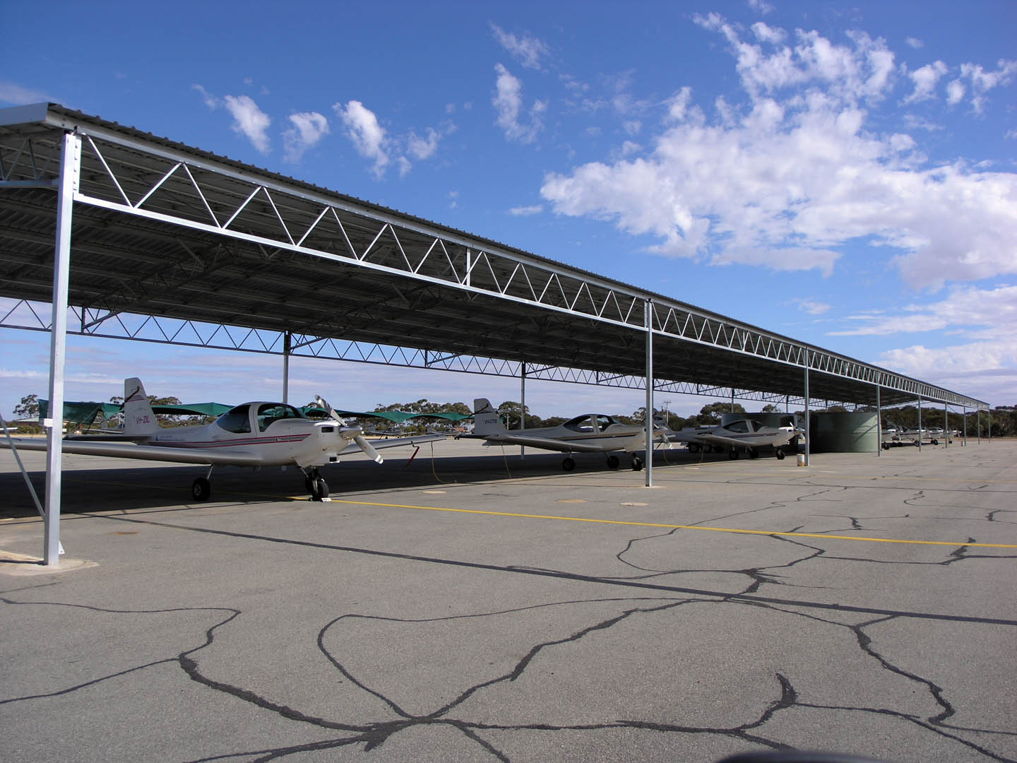
Merredin aerodrome is leased under a 100-year lease arrangement by China Southern Airlines and is used as a pilot training facility by the China Southern West Australian Flying College, who also operate from Jandakot Airport in Perth. Locals can tell that the airport was leased for the sum of one Australian Dollar with the state government banking that investment would follow.[3] The partnership in the years since has been successful. Upgraded facilities include bitumen runways, a control tower, fire control equipment, hangars, classrooms, and housing. Although the aerodrome is leased by China Southern Airlines, the RFDS and private users still have access.
Merredin serves as the middle stop of the Prospector train. At Merredin, the train stops for a scheduled 10 minutes, giving passengers a chance to stretch their legs. There, the train stewards disembark and serve the Prospector going back to Perth, so they never go any farther. The same is true for Kalgoorlie stewards, who disembark and get onto the Kalgoorlie train. It is also the terminus for the Avonlink rural train service.
Things to see[]


Merredin Railway Water Tower and Great Eastern Highway
- Merredin Railway Water Tower
- Merredin Railway Museum
- Merredin Military Museum
- C.B.H. Grain Transfer Terminal
- Merredin Aerodrome
- Cummins Theatre
- Hunt's Dam
- Mosaics
- Mangowine Homestead
- Totagin Rock
- The Quarry
- Merredin Rock
- Railway Dam and Heritage Trail
- Merredin Railway Institute Hall[4]
Notable people[]
The following people were either born or raised in Merredin and have gone on to achieve successful careers in a wide range of areas.
- Paolo Amaranti – Chief Executive Officer of Rottnest Island.
- Tully Bevilaqua née Crook – women's basketball player for Indiana Fever in the USA and in Australia, Canberra Capitals
- David M. Churchill[5] – Director of the Royal Botanic Gardens and Government Botanist of Victoria 1971–85
- Hon Hendy Cowan – former leader of the National party and Member for Merredin
- Tony Crook – National Party politician and member for O'Connor, RFDS executive officer
- Captain Brett Dowsing – commanding officer of naval base HMAS Stirling
- Archie Duda – former East Perth full forward
- Jeff Garlett – former Swan Districts and now Carlton footballer
- Dr Geoffrey Gibbs AM[6] – actor, head of the WA Academy of Performing Arts, Chairman of Trustees for the International Foundation for Arts and Culture
- Rick Hart[7] – businessman and public speaker, former President of Fremantle Football Club
- Robert Juniper – one of Australia's most prominent landscape artists, recently declared a Living Legend by the Australia government
- Allan Langoulant[8] – illustrator
- Ken McAullay – former WA and East Perth full back and WA Sheffield Shield cricketer
- Laurie Mayne – former Test cricketer
- Imre Mencshelyi – Former CBH CEO
- Margaret Mills – famed international botanist
- Don Randall – Australian Liberal party politician, currently the Member for Canning
- Jack Rutherford – first Western Australian cricketer to win a Test cap for Australia
- Nelly Thomas[9] – winner of National Raw Comedy Competition in 2003
- Nicole Trunfio – won the Australian Search for a Supermodel series in 2003, then came third in the international version of the series. Now one of the most highly sought after models in the world.
- Arthur Upfield – author of Boney series; worked at Burracoppin
- Bill Walker OAM – football legend in the WAFL. Winner of four Sandover Medals. Grew up in the neighbouring town of Narembeen. A former student of Merredin Senior High School.
References[]
- ^ Australian Bureau of Statistics (31 October 2012). "Merredin ( State Suburb)". 2011 Census QuickStats. http://www.censusdata.abs.gov.au/census_services/getproduct/census/2011/quickstat/SSC50491?opendocument&navpos=220. Retrieved 2012-09-28.
- ^ "Climate statistics for Merredin". Australian Bureau of Meteorology. http://www.bom.gov.au/climate/averages/tables/cw_010092.shtml. Retrieved 20 August 2009.
- ^ Transcript – Chinese airline sends trainee pilots to the bush Broadcast: 05/11/2004. Reporter, Michael Edwards, Stateline, ABC. Retrieved 17 September 2006.
- ^ http://www.youtube.com/watch?v=sObsg8REsPg
- ^ Churchill, David M. (1933 – ) Australian National Botanic Gardens. Retrieved 17 September 2006.
- ^ WAAPA Teacher Broadcast 6.30pm on 15 August 2002. New Dimensions, ABC. Retrieved 17 September 2006.
- ^ Speaker Rick Hart – Full Biography ICMI 2006. Retrieved 17 September 2006.
- ^ Alan Langoulant www.cbc.org.au. Retrieved 17 September 2006.
- ^ Official Nelly Thomas website www.nellythomas.com. Retrieved 17 September 2006.
External links[]
| |||||
| This page uses content from the English language Wikipedia. The original content was at Merredin, Western Australia. The list of authors can be seen in the page history. As with this Familypedia wiki, the content of Wikipedia is available under the Creative Commons License. |