| Main | Births etc |
|---|
| Northampton | |
|---|---|
| — Town, borough and non-metropolitan district — | |
 |
|
 |
|
| Coordinates: | |
| Sovereign state | United Kingdom |
| Constituent country | England |
| Region | East Midlands |
| Ceremonial county | Northamptonshire |
| Admin HQ | Northampton Guildhall |
| Town charter | 1189 |
| Incorporated | 1835 |
| Government | |
| • Type | Non-metropolitan district administered by two-tier structure of government |
| • Governing body | Northampton Borough Council Northamptonshire County Council |
| • Leader | Borough Council Mary Markham (Con) County Council Heather Smith (Con) |
| • Mayor | Christopher Malpas (Con) |
| • MPs | Michael Ellis (Con) Andrea Leadsom (Con) David Mackintosh (Con) |
| Elevation | 180 ft (55 m) |
| Population (2006 est.) | |
| • Total | 212,500 (Ranked 73rd) |
| • Density | 6,810/sq mi (2,631/km2) |
| • Ethnicity | 84.5% White 6.4% South Asian 5.1% Black 3.2% Mixed Race 0.3% Arab 0.5% Other |
| Demonym | Northamptonian |
| Time zone | GMT (UTC0) |
| • Summer (DST) | BST (UTC+1) |
| Postcode area | NN1—NN7 |
| Area code(s) | 01604 |
| ISO 3166-2 | GB-NTH |
| ONS code | 34UF (ONS) E07000154 (GSS) |
| NUTS 3 | UKF24 |
| Website | northampton.gov.uk |
Northampton /nɔ:ˈθæmptən/ is the county town of Northamptonshire in the East Midlands of England. It lies on the River Nene, about 67 miles (108 km) north-west of London and 50 miles (80 km) south-east of Birmingham. One of the largest towns in the UK,[1] Northampton had a population of 212,100 in the 2011 census.
Archaeological evidence of settlement in the area dates back to the Bronze Age, Roman and Anglo-Saxon periods. During the Middle Ages, the town rose to national significance with the establishment of Northampton Castle, which was an occasional royal residence and regularly hosted the Parliament of England. Medieval Northampton had many churches, monasteries and the University of Northampton, which were all enclosed by the town walls. It was granted its first town charter by King Richard I in 1189 and its first mayor was appointed by King John in 1215. The town is also the site of two medieval battles; the Battle of Northampton (1264) and the second in 1460.
Northampton's royal connection languished in the modern period; the town supported Parliament (the Roundheads) in the English Civil War, which culminated in King Charles II ordering the destruction of the town walls and most of the castle. The town also suffered the Great Fire of Northampton (1675) which destroyed most of the town. It was soon rebuilt and grew rapidly with the industrial development of the 18th century. Northampton continued to grow following the creation of the Grand Union Canal and the arrival of the railways in the 19th century, becoming an industrial centre for footwear and leather manufacture.
After the World Wars, Northampton's growth was limited until it was designated as a New Town in 1968, accelerating development in the town. Northampton unsuccessfully applied for unitary status in 1996 and city status in 2000; the town continues to expand with many areas undergoing urban renewal. According to Centre for Cities data in 2015, Northampton had a population growth of 11.3% between the years 2004 and 2013, one of the ten highest in the UK.[2]
History[]
Etymology[]
The earliest reference to Northampton in writing occurred in 914 under the name Ham tune, literally meaning "home town".[3] The prefix "North" was added later to distinguish it from other towns called Hampton, most prominently Southampton.[4] The Domesday Book (1086) records the town as Northantone, which evolved into Norhamptone by the 13th century and later Northampton by the 17th century.[3][5]
Ancient[]
Earthworks at Hunsbury Hill, which was a settlement during the Iron Age.
Present-day Northampton is the latest in a series of settlements that began in the Bronze Age. Remains found in the Briar Hill district show evidence of a Neolithic encampment within a large circular earthwork where local farmers assembled for tribal ceremonies and seasonal events from approximately 3500 BC to 2000 BC.[6][7]
During the British Iron Age, people typically lived in protected hill forts. Present-day Hunsbury Hill is an example of this settlement; a circular ditch and a bank faced with a wall of timber and enclosing an area of 160 acres (65 ha) which dates to around 400 BC.[8] In the Roman period, a small rural settlement is thought to have existed in the present-day district of Duston; remains of Roman pottery were found there.[9]
Following Danish invasion, the central area of the town was turned into a stronghold called a burh and became the base for one of the Danish armies in 850. A ditch was dug around the settlement and it was fortified with earth ramparts.[10] Having conquered Mercia, the Danes turned the settlement into a centre for military and administrative purposes, which was part of the Danelaw.
In the 9th century Regenhere of Northampton[11][12] an East Anglian Saint with localised veneration was buried in Northampton. By 918, Northampton had an earl and an army dependent upon it, whose territory extended to the River Welland.[3]
The settlement was recovered by Edward the Elder the same year, turning it into the centre of one of the new shires, which prospered as a river port and trading centre.[3] In 940, it successfully resisted the invading forces of Danish opposition in Northumbria, but was burnt in 1010 by a Danish army, and again in 1065 by the rebellious northern earls Edwin and Morcar. Despite this, the Domesday Book records Northantone as possessing 316 houses with a population of 2000 people, ranking between Warwick and Leicester in size.[3][4]
Medieval[]


Northampton Castle was a royal residence and held the Parliament of England, but suffered many fates and was eventually demolished for a railway station. A postern (above), dismantled from its original position and rebuilt into a wall by the station, is all that remains.
With the Norman conquest of England, the town rose to national significance: its geographical location in the centre of England made Northampton a valuable strategical point for government and as a convenient meeting place for political, social, ecclesiastical and military events.[3][13]
Northampton Castle is thought to have been built by Simon de Senlis, who became the first Earl of Northampton, circa 1084.[3] It was originally an earth and timber stockaded construction which was later rebuilt in stone.[14] The castle became an occasional royal residence from the reign of King Henry I in 1130 until that of King Richard II.[13] King John regularly stayed at the castle and moved The Treasury there in 1205. Many Parliaments, including the Parliament of England, were held there. The last Parliament at Northampton was held in 1380. Significant events in the castle's history include the trial of Thomas Becket in 1164, the publication of the Assize of Northampton in 1176, the declaration of peace with Scotland in the Treaty of Edinburgh–Northampton, the passage of the Statute of Northampton in 1328 and the imposition of poll tax in 1380. Royal tournaments and feasts were also held at the castle.[3][14]
Simon de Senlis is also thought to have built the medieval town walls, which enclosed about 245 acres (99 ha) and had four main gates. Though demolished now, the circular pattern of the main roads surrounding the town centre marks the original position of the walls.[14] de Senlis founded the Cluniac Priory of St Andrew's – where St Andrew's Hospital now stands – and built The Church of the Holy Sepulchre – one of four remaining round churches in England – and All Hallows Church on the current site of All Saint's Church.[3][14] His son, Simon II de Senlis, built St Peter's Church on a site between a former Anglo-Saxon palace and Northampton Castle.[14] Simon II de Senlis also founded Delapré Abbey – another Cluniac priory – which still stands today. Other priories in medieval Northampton include St James' Abbey, Graye Friers, Blackfriars and Whitefriars. St. John's, a medieval hospital, was situated east of Bridge Street.[14] A large network of medieval tunnels remains under the centre of Northampton around All Saint's Church; their purpose has been disputed.[15]
The town was originally controlled by officials acting for the King who collected taxes and upheld the law. This changed on 18 November 1189 when King Richard I granted the town its first charter in exchange for money to fund his crusades.[3] The charter allowed the townspeople certain rights and independence in legal and administrative matters. In 1215, King John authorised the appointment of William Tilly as the town's first Mayor and ordered that "twelve of the better and more discreet [residents] of your town" join him as a council to assist him.[3][16] The importance of Northampton at this time is underlined by the fact that only London, York and King's Lynn had mayors by this date.[14] The mayor later ruled with 24 councillors and 48 freemen in a closed body until 1835.[14]
Markets and fairs were a key element in the town's economy in medieval times. The Market Square came to prominence in 1235 when Henry III ordered that the selling of goods in the churchyard of All Saint's should be relocated to the Market Square.[14] Street names in the town give an indication of trades and market centres; Corn Hill, Malt Hill, Mercer Row, Gold Street, Sheep Street and Horse Market.[14] Cloth and wool were very important but these industries declined.[14] In the 13th century, Northampton had a large Jewish population centred on Gold Street. In 1277 – two years after Edward I passed the Statute of the Jewry – some Jewish residents were executed while the remainder were driven out of town.[17] Archaeological sites include a medieval Jewish cemetery and the Northampton Medieval Synagogue.[18]
The First Barons' War caused significant destruction to Northampton. The barons besieged Northampton Castle in protest at King John's oppression of his subjects. In retaliation, royalist forces destroyed a large part of the town. When the forces of King Henry III overran the supporters of Simon de Montfort, the Second Barons' War broke out. The first Battle of Northampton – a battle in the second civil war – took place in 1264 at the site of Northampton Castle where King Henry III and his son Prince Edward attacked with a large army, pillaged the town and took prisoners.
In 1349, the Black Death pandemic killed more than half the population of Northampton. In 1377, the population was 2,200.[13] The town was rapidly losing its wealth and its importance as a national centre. In 1460, the second Battle of Northampton took place during the War of the Roses in the meadows between the River Nene and Delapré Abbey. The Yorkists defeated the Lancastrians and King Henry VI was taken prisoner. In 1484, the Mayor declared that Northampton was "in great desolation and ruin". The dissolution of the monasteries in 1538 led to further destruction of what remained of the medieval town. Northampton was severely affected by Plague between March and September 1638 when 533 people – a seventh of the population – died.
Modern[]
The royal connection to Northampton Castle became less significant, and by the time of the English Civil War, Northampton was decidedly pro-Parliament.[14] Though Spencer Compton, Earl of Northampton, was a royalist (Cavalier) and backed King Charles I, the people of Northampton supported Parliament and Oliver Cromwell's republican Roundhead army. The town had a long history of religious dissent from the Lollards and Puritanism gained a strong hold on the town. The corporation of the town, having already refused to provide troops to the King in 1632 or to pay the notorious ship money tax in 1636, petitioned Parliament in 1642 against papists and bishops.[14]
When war broke out in 1642, the town willingly became the main Parliamentarian garrison for the south-east Midlands area with the former royal castle as its headquarters. In 1643, Prince Rupert attacked Northampton with approximately 2,000 men, but was beaten back at the North Gate of the town. Oliver Cromwell visited in 1645 and General Fairfax marched from the town to Naseby, where Charles I's Royalist army was decisively defeated.[14] Over 4,000 pairs of leather shoes and 600 pairs of cavalry jack-boots for the Parliamentary armies were manufactured in Northampton during the Civil War, and a further 2,000 for Cromwell's New Model Army in 1648. Until well into the 19th century, the shoe industry boomed in and around the town with small manufacturing workshops set up in the surrounding areas.[14]
The War ended with a Parliamentary victory, resulting in England becoming a Commonwealth, which lasted a decade. Following the restoration of King Charles II in 1660, he took revenge on the town by ordering the destruction of its walls and partial demolition of its castle in 1662, since it did not support his father Charles I and his cavaliers.[19] From then on, the castle was used as a court and a gaol, but its physical condition worsened.[19] The new council of the town had to pay £200 to have its charter renewed and also required all officials to swear the oath of allegiance and some confirmed by the Crown.[14]
Sessions House was one of the first buildings built after the Great Fire of Northampton (1675)
The town centre was further destroyed by the Great Fire of Northampton in 1675, caused by sparks from an open fire in a thatched cottage by the castle. The fire spread eastwards by strong westerly winds and consumed three-quarters of the town centre in 24 hours.[14][20] Matters were worsened because most buildings were chiefly made of wood and covered with thatch.[4] An estimated 600 buildings were destroyed, amounting to £150,000 lost.[20] Very little survived the fire, apart from buildings made of stone, like the Welsh House on Market Square, built in 1595, and Hazelrigg House in Mare Fair, built in 1662.[14]
The devastation led to an Act of Parliament for the rebuilding the town.[4] Local people and businesses helped to raise around £25,000 towards the rebuilding of the town centre based around the Market Square.[20][21] Streets were widened and buildings made of brick and stone and tiled to prevent such devastation again.[14] In an act of reconciliation, King Charles II donated timber from the royal forests of Salcey and Whittlebury to help with the rebuild.[14][22] In 1678, the Sessions House and what is now County Hall were amongst the first buildings to be completed.[23] A Georgian town with new houses, shops and workshops eventually grew out of the old medieval town destroyed by the fire.[14] In 1741 Edward Cave opened Marvel's Mill, the world's first cotton mill to be driven by a water wheel.[24]
A permanent military presence was established in the town with the completion of Gibraltar Barracks in 1797.[25]
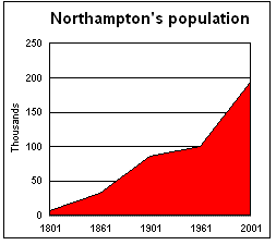
By the end of the 18th century, Northampton had become a major centre of footwear and leather manufacture. In 1801, the population was 7,020; it more than doubled to 15,351 in 1831, attributed to the fact that there was great demand for footwear caused by the Napoleonic Wars of the late 18th and early 19th centuries.[14] A third of the adult males alone were shoemakers at the time.[14] Northampton grew beyond the old town walls and industry grew rapidly with the mechanisation of factories by the middle of the 19th century.[14]
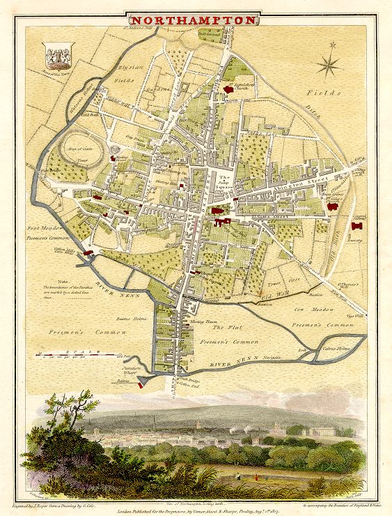

A map of Northampton in 1810
The Nene Navigation Company had previously made the River Nene navigable from King's Lynn as far up as Northampton in 1762, allowing cheap transportation of coal and other goods to the town, but in 1815, the Grand Union Canal reached the town, joining the River Nene, giving the town a direct link to the Midlands coalfields and to Birmingham, Manchester and London.[3]
The first railway to be built into Northampton was a branch from the main London-Birmingham line at Blisworth to Peterborough through Northampton which opened in 1845 alongside the town's first railway station, Bridge Street station. This was followed by the opening of Castle station in 1859 on the site of part of the historic Northampton Castle,[3][26][27][28][29] and later St. John's Street station in 1872. The Northampton loop of the West Coast Main Line was built in the late 1870s. Castle station was rebuilt and expanded over the site of Northampton Castle, the remains of which were purchased and demolished in 1880 to make way for the goods shed.[30] Bridge Street Station closed in 1964 and St John's Street closed in 1939,[31][32][33] leaving only Castle station serving the town.[34] It is now known simply as Northampton railway station.
Tram lines were also laid down in the town in 1881 and electrified in 1903.[3] An early omnibus service ran to Wellingborough, and since 1919 motor omnibus services ran to villages around the town which brought buyers and sellers to the market.[3]
Contemporary[]
Following World War I, the shoe industry was increasingly in decline, despite the town's factories supplying over 23 million pairs of boots to the armed forces.[14] A total of 1,700 men from the town were lost of the 6,000 killed from the Northamptonshire Regiment.[14] The town expanded further during the 1920s and saw the erection of Northampton Power Station, which supplied electricity to areas as far away as Wolverton, until its closure in 1975. Much council housing was also built largely to the east, north and south of the town, including Abington, Far Cotton, Kingsley, Kingsthorpe and Dallington – areas which had been incorporated within the borough's boundaries in 1901.[14] However, the population growth slowed down as people moved beyond its boundaries. In 1901, the population had expanded to 90,923; in 1931, the population was 92,341.[14]
After World War II, Northampton vastly changed. In 1959, the M1 motorway was opened to the south-west of the town; in 1968, Northampton was designated a New Town. Both these events and the rail link helped Northampton's growth as a commuter town for London.[14] The Northampton Development Corporation (NDC) was set up in 1968 to substantially redevelop the town in partnership with the local council, spending £205 million to build new housing and industrial estates, initially in Lumbertubs, Moulton Park and Round Spinney to the east, followed by Briar Hill, Camp Hill and East and West Hunsbury in the south of the town, mainly to accommodate the overflow population of new residents from the London area.[14][35] In the town centre, older buildings were demolished and replaced or redeveloped for other buildings, including the former Greyfriars bus station, the Grosvenor Centre, Peacock Place (now Market Walk), shops, flats and hotels.[14]
Although growth was slower than planned, the population grew from 105,421 in 1961 to 157,217 by 1981,[14] with 15,655 new homes added to the town between 1970 and 1985.[35] The borough boundaries also changed following a split of the Northampton parliamentary constituency into Northampton North and Northampton South in 1974. Northampton was reconstituted as a non-metropolitan district which also covered areas outside the former borough boundaries but inside the designated New Town. The town tried for unitary status during the 1990s UK local government reform, but failed and remains a non-metropolitan district to this day, meaning it relies on a two-tier system of government.On Good Friday 1998, Northampton suffered severe flooding, particularly in the areas of Far Cotton and St James; two people were killed and thousands of homes were affected.
Since the turn of the Millennium, the town has continued to expand. Northampton applied for city status in 2000 and again in 2002, but failed on both occasions and remains a town.[36][37][38] In 2006, Northampton became a government expansion zone with new growth promoted by West Northamptonshire Development Corporation (WNDC), an unelected quango, which has provoked a series of regeneration schemes across the town. Some have been completed, including the opening of the Radlands Plaza Skatepark and the development of Becket's Park Marina just south of Northampton's town centre, as well as the improvement of the town's Market Square, the building of the new North Gate bus station, the redevelopment of the railway station and the creation of a Cultural Quarter. Current projects include the improvement of Northampton's waterside, the building of a new Council headquarters, the restoration of Delapre Abbey, the expansion of Northampton Museum, the merging of the university into one new campus in town centre and the renovation of both the Grosvenor Shopping Centre and Weston Favell Centre.[39] In 2015, St Giles Street in the town centre was named the "Best British High Street" in a national competition run by the Department for Communities and Local Government.[40]
Administration[]
Politics[]


Statue of the Northampton MP Charles Bradlaugh in the town.
- For more details on Northampton South (UK Parliament constituency), see Northampton North (UK Parliament constituency).
The Northampton constituency was established in 1295, which returned two MPs to the House of Commons. Spencer Perceval was the elected MP for the constituency in 1796, and became Prime Minister of the United Kingdom in 1809, the only Solicitor General or Attorney General to have been Prime Minister, but also the only Prime Minister to have been assassinated. John Bellingham shot him dead in the House of Commons lobby in 1812. By the late 19th century, Northampton had acquired a reputation for political radicalism. In 1880, radical non-conformist Charles Bradlaugh was elected as second MP for the constituency. During an election campaign involving Bradlaugh, a riot broke out in the Market Square that required military to disperse the action. For the 1918 general election, Northampton's representation was reduced to one MP.
The original constituency was abolished for the February 1974 general election and replaced by the new constituencies of Northampton North and Northampton South, which elect one MP each. These boundaries changed further for the 2010 general election when the South Northamptonshire constituency was created, covering the most southern areas of the borough. The borough of Northampton continues makes up all of the electoral wards in Northampton North and Northampton South.
Northampton is currently represented by three Conservative MPs: David Mackintosh (Northampton South), Michael Ellis (Northampton North) and Andrea Leadsom (South Northamptonshire). Northampton is also included in the East Midlands constituency for elections to the European Parliament, electing five MEPs using the d'Hondt method of party-list proportional representation.
Local government[]
- For more details on this topic, see Local government in Northampton.
|
Northampton Borough Council |
Northamptonshire County Council |
The town existed as an ancient borough in the medieval period before being one of the 178 boroughs to be reformed under the Municipal Corporations Act in 1835, with a democratically-elected council replacing the Tory corporation before it.[14] Town government alternated between the Liberals and Conservatives, and the town achieved independence from Northamptonshire in 1888 when it became a county borough.[14] It had 6 electoral wards from 1898, 9 wards from 1900 and 12 wards from 1911.[3]
Northampton was granted modern borough status in 1974, when it was reconstituted as a non-metropolitan district, a subdivision of its non-metropolitan county (Northamptonshire).[41][42] The town currently has a two-tier structure of local government: the non-metropolitan district of Northampton is administered by both Northampton Borough Council and Northamptonshire County Council, which are both controlled by the Conservative Party.
The borough failed to become an unitary authority in the 1990s local government reform and again, in 2011, when the motion was voted down by the council.[43][44] However, in 2016, the borough council and all seven Northamptonshire MPs proposed to draw up plans for Northampton to become an unitary authority.[45][46]
Policing in the town remains the responsibility of Northamptonshire Police; and firefighting, the responsibility of Northamptonshire Fire and Rescue Service. The Royal Anglian Regiment serves as the county regiment for Northamptonshire.
Health services[]
NHS Northampton guides primary care services (general practitioners, dentists, opticians and pharmacists) in the town, directly provides adult social care and services in the community such as health visiting and physiotherapy and also funds hospital care and other specialist treatments. Northampton General Hospital is an NHS trust hospital which founded in 1744 and moved to its present site in 1793, and has continued to provide healthcare to the local community for more than 200 years. The East Midlands Ambulance Service NHS Trust is responsible for the provision of statutory emergency medical services in Northampton.
St Andrew's Hospital, the flagship mental health facility of the private company St Andrew's Healthcare, is also based in Northampton. originally opened in 1838 to serve Northampton St Andrew's became a charity and private healthcare provider when the Berrywood Asylum (later the Northampton County Lunatic Asylum, then St Crispin Hospital in 1948, and since 2010 Berrywood Hospital) opened in 1876.
Geography[]
Areas and suburbs[]
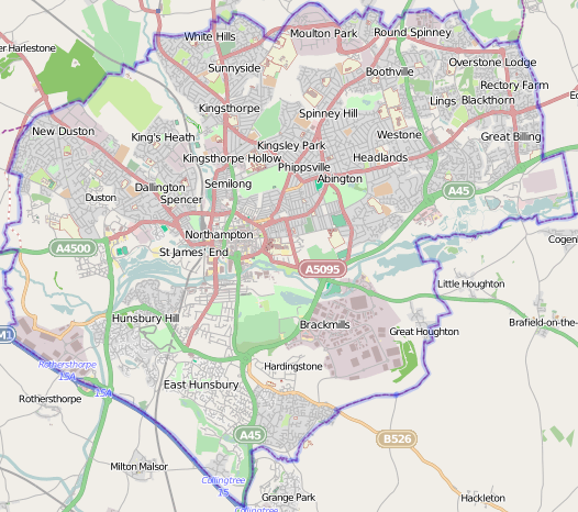
Map of the town suburbs


Extracts from OS Maps SP75 and SP76 (1956 & 1955 respectively). Grid squares are 1km
Northampton is subdivided into suburbs, council wards, constituencies, ecclesiastical parishes, and other less formal areas.
There are 33 electoral wards, as defined by the borough council (the county council divides the town into much larger wards which have different boundaries), in Northampton:[47]
- Abington
- Billing
- Boothville
- Brookside
- Castle
- Delapre and Briar Hill
- East Hunsbury
- Eastfield
- Headlands
- Kings Heath
- Kingsley
- Kingsthorpe
- Nene Valley
- New Duston
- Obelisk
- Old Duston
- Park
- Parklands
- Phippsville
- Rectory Farm
- Riverside
- Rushmills
- Semilong
- Spencer
- Spring Park
- St David's
- St James
- Sunnyside
- Talavera
- Trinity
- Upton
- West Hunsbury
- Westone
The most northern wards make up the Northampton North parliamentary constitency; the most southern make up the Northampton South parliamentary constituency. However, East Hunsbury, West Hunsbury and Nene Valley are included in the South Northamptonshire parliamentary constituency.
Nine registered parish councils also lie within the borough of Northampton. These are Billing, Collingtree, Duston, Great Houghton, Hardingstone, Hunsbury Meadow, Upton, West Hunsbury and Wooton & East Hunsbury.[48] There are also settlements outside the town boundaries that are sometimes considered suburbs of Northampton, including Boughton, Cogenhoe, Ecton, Grange Park, Harpole, Little Houghton, Moulton, Overstone and Rothersthorpe.
Compass[]
Northampton's nearest towns are Wellingborough, Daventry and Towcester. The nearest cities are Coventry, Leicester and Peterborough.

|
Rugby, Coventry, Birmingham | Market Harborough, Leicester, Loughborough, Nottingham | Kettering, Corby |
|
| Daventry, Long Buckby, Stratford-upon-Avon, Worcester | Earls Barton, Wellingborough, Rushden | |||
 Northampton | ||||
| Towcester, Brackley, Banbury, Oxford | Milton Keynes, Aylesbury | Bedford, Dunstable, Luton, London |
Climate[]
As with the rest of the British Isles, Northampton experiences a maritime climate with cool summers and mild winters. The official Met Office weather station for Northampton is the Moulton Park Weather Station at the University of Northampton. Situated at an elevation of around 130 m (427 ft) above sea level compared to Northampton town centre at 50 to 60 m (164 to 197 ft), it is one of the highest points in the Borough, and so may not be a perfect representation of other parts of the town. Its hilltop location means less pooling of cold air on calm clear nights, and lower maxima during summer. The absolute maximum recorded is 34.7 °C (94.5 °F)[49] on 3 August 1990. A high of 34.4 °C (93.9 °F)[50] was recorded on 19 July 2006. The absolute minimum is −16.8 °C (2 °F),[49] recorded during February 1986. It is likely the absolute maximum in the town centre is a degree or so higher owing to the lower elevation, and absolute minimum on the eastern and western edges of the Borough around the Nene valley a couple of degrees colder due to katabatic drainage of cold air allowing a frost hollow effect. Most recently, the temperature fell to −9.6 °C (15 °F)[51] on 20 December 2010.
Rainfall, at around 650 mm (26 in) per year is not high, though is often unpredictable, giving rise to flooding events such as 1998, but also short term droughts. Desborough Weather Station also supplies the public with a local weather service.
| Climate data for Northampton Moulton Park, elevation 127m, 1981–2010 | |||||||||||||
|---|---|---|---|---|---|---|---|---|---|---|---|---|---|
| Month | Jan | Feb | Mar | Apr | May | Jun | Jul | Aug | Sep | Oct | Nov | Dec | Year |
| Average high °C (°F) | 6.8 (44.2) |
7.1 (44.8) |
10.0 (50.0) |
12.8 (55.0) |
16.2 (61.2) |
19.2 (66.6) |
21.7 (71.1) |
21.5 (70.7) |
18.4 (65.1) |
14.1 (57.4) |
9.7 (49.5) |
7.0 (44.6) |
13.7 (56.7) |
| Average low °C (°F) | 1.1 (34.0) |
0.9 (33.6) |
2.7 (36.9) |
4.0 (39.2) |
6.8 (44.2) |
9.7 (49.5) |
11.9 (53.4) |
11.8 (53.2) |
9.8 (49.6) |
7.0 (44.6) |
3.7 (38.7) |
1.5 (34.7) |
5.9 (42.6) |
| Precipitation mm (inches) | 54.0 (2.126) |
41.1 (1.618) |
44.1 (1.736) |
49.4 (1.945) |
54.4 (2.142) |
54.9 (2.161) |
49.2 (1.937) |
54.5 (2.146) |
57.6 (2.268) |
63.9 (2.516) |
60.0 (2.362) |
55.3 (2.177) |
638.1 (25.122) |
| Mean monthly sunshine hours | 55.7 | 77.9 | 108.2 | 151.4 | 189.9 | 173.8 | 199.3 | 185.2 | 134.0 | 109.6 | 64.4 | 49.5 | 1,498.9 |
| Source: Met Office[52] | |||||||||||||
| Climate data for Northampton Moulton Park, elevation 127m, 1971–2000. Rainfall data Althorp, elevation 122m, 1841–1987 | |||||||||||||
|---|---|---|---|---|---|---|---|---|---|---|---|---|---|
| Month | Jan | Feb | Mar | Apr | May | Jun | Jul | Aug | Sep | Oct | Nov | Dec | Year |
| Average high °C (°F) | 6.4 (43.5) |
6.8 (44.2) |
9.5 (49.1) |
11.9 (53.4) |
15.6 (60.1) |
18.5 (65.3) |
21.2 (70.2) |
21.1 (70.0) |
17.9 (64.2) |
13.7 (56.7) |
9.3 (48.7) |
7.2 (45.0) |
13.3 (55.9) |
| Average low °C (°F) | 0.8 (33.4) |
0.6 (33.1) |
2.3 (36.1) |
3.5 (38.3) |
6.3 (43.3) |
9.2 (48.6) |
11.5 (52.7) |
11.5 (52.7) |
9.5 (49.1) |
6.6 (43.9) |
3.3 (37.9) |
1.7 (35.1) |
5.6 (42.1) |
| Precipitation mm (inches) | 54.7 (2.154) |
42.6 (1.677) |
44.9 (1.768) |
45.5 (1.791) |
53.5 (2.106) |
55.4 (2.181) |
64.1 (2.524) |
64.3 (2.531) |
58.3 (2.295) |
66.1 (2.602) |
61.3 (2.413) |
56.7 (2.232) |
668.5 (26.319) |
| Source #1: YR.NO[53] | |||||||||||||
| Source #2: WorldClimate[54] | |||||||||||||
Demography[]
Northampton had an estimated population of 212,069 at the 2011 census. The town's population recorded at each census since 1991 was as follows:[55][56]
| Year | Population |
|---|---|
| 1991 | 180,617 |
| 2001 | 194,458 |
| 2011 | 212,069 |
| Northampton ethnicity demographics from the 2011 census[56] | |
|---|---|
| Ethnicity | Population |
| White (British, Irish, Other) |
179,238 |
| Asian (Bangladeshi, Chinese, Indian, Pakistani, Other) |
13,751 |
| Black (African, Caribbean, Other) |
10,741 |
| Mixed (White & Asian, White & Black African, White & Black Caribbean, Other) |
6,849 |
| Arab | 543 |
| Other | 947 |
Since 1991, the population of the town has increased 17.41% from 180,617 to 212,069 in 2011, with a mean age in 2011 of 37.1 years, younger than the English average of 39.3 years.[57] The population breaks down into 104,168 males, and 107,901 females, with a population density of 2,630 per km2.[58]
At the 2011 census, there were 91,484 dwellings, 88,731 of which are occupied households. Some 30.5% (27,048) of these were one person households, 61.1% (54,125) contained families, and 8.5% (7,558) fell into the other household type category.[59] Home tenure was reported as 37.5% of 88,731 households mortgaged, 25.1% owned outright, 16.5% privately rented, 12.8% rented from council, 4.3% social rented, 1.3% private (other) rented, 1.3% shared ownership and 1.2% rent free.[60]
75.6% of households had at least one car or van, 22.5% of residents over the age of 16 had no formal qualifications, and 15.8% have at least 5 GCSEs of grade C or above.[61] The median income for all workers (in 2012) was £21,193, slightly below both the county average of £21,560, and the England average of £21,794.[62]
Between 2001 and 2011, the greatest nominal population increase was in the White, Other group from 3,780 to 13,825 – an increase of 10,045 – likely due to migration from Eastern Europe. The largest growth relative to their 2001 numbers was in the Black, African group, recording a 376% increase from 1,361 to 6,473. The largest nominal fall in population was in respondents reporting as White, British, there being 8,146 fewer such residents in 2011 than 10 years previous. The largest fall relative to their 2001 numbers was in the White, Irish group, their count falling 20.3% from 3,838 down to 3,060.
In terms of religion, 56.6% of residents described themselves as Christian, 29.4% reported no religion, 4.2% Muslim, 1.6% Hindu, 0.5% Sikh, 0.5% Other, 0.4% Buddhist and 0.1% Judaism. 6.7% failed to report any affiliation.[63]
Economy[]


The Barratt Boot and Shoe factory operational since 1911.
Northampton was a major centre of shoemaking and other leather industries, although only specialist shoemaking companies such as Wildsmith Shoes,[64] Edward Green Shoes, Crockett & Jones, Church's[65] and Trickers,[66] formerly located in nearby Earls Barton, survive. A large number of old shoe factories remain, mostly now converted to offices or accommodation, some of which are surrounded by terraced houses built for factory workers.
Engineering became a major employer in Northampton during the post war years following the establishment of the British Timken tapered roller bearing factory at Duston in 1941 as a shadow factory for the main site in Birmingham during the Second World War. The factory which closed in 2002 employed over 4,000 employees at its peak and was a major engineering apprentice training employer.
Northampton's main private-sector employers are now in distribution and finance rather than manufacturing, and include Avon Products,[67][68] Barclaycard, Blacks Leisure Group, Nationwide Building Society (Anglia Building Society was formed by amalgamation of Northampton Town and County Building Society with Leicestershire Building Society in 1966 and subsequently merged with the Nationwide in 1987),[69] Panasonic, Travis Perkins, Coca-Cola, Schweppes, Simply Business,[70] National Grid, Texas Instruments and Carlsberg.[71] In 1974, Princess Benedikte of Denmark opened Northampton's Carlsberg brewery, the first outside Denmark.[72] The University of Northampton is also a major employer, as is St Andrew's Healthcare, a national mental health charity. St Andrew's Hospital, its flagship hospital and the United Kingdom's largest psychiatric hospital, is based in Northampton. In 2014, Experian named Northampton as "the best place in the UK to start and run a business."[73]
Culture[]
Leisure[]


The Market Square at night
Northampton's market square is one of Britain's largest and most historic which dates back to 1235. The market square is linked to Abington Street, a major shopping area of Northampton. The western part of the street was pedestrianised in 1984. The eastern part was pedestrianised in 1995 and de-pedestrianised in 2014.[74] There are also two shopping centres in the town centre: the Grosvenor Centre, which was built in the 1970s, and Market Walk (previously Peacock Place), which was constructed in 1988. St James Retail Park is also a large shopping precinct just south of the town centre. Many out-of-town retail parks exist like Weston Favell Shopping Centre, built in the 1970s, and Riverside Retail Park in the east of the town, as well as Sixfields in the west. Each precinct has a range of high street shops, department stores and many smaller individual speciality shops.
Billing Aquadrome leisure park is on the eastern outskirts with a caravan site, marina, funfair, bar, riverside restaurant and converted water mill with original workings. The Northampton Leisure Trust has four leisure centres across Northampton: Danes Camp, Lings Forum, Mounts Baths and Duston Sports Centre. There are also the action centres Benham Sports Arena and King's Park Tennis Centre as well as the Delapre Public Golf Course. Radlands Plaza is a new skatepark that opened in 2012.
According to the website of the Northampton Borough Council, there are a total of 170 parks and open spaces around Northampton, which altogether span around 1,880 acres (761 ha).[75] Popular parks include Abington Park, which is the town's oldest, and the Racecourse, which was used for horseracing (until 1904) and as a cricket ground (between 1844–1885) in addition to being the original home of Northampton Balloon Festival. Other parks include Becket's Park (which is named after Thomas Becket as are nearby Becket's Well and Thomas á Becket pub), Bradlaugh Fields (named after the Northampton MP Charles Bradlaugh), Dallington Park, Delapré Park, Eastfield Park, Hunsbury Hill (which is built around an Iron Age fort), Kingsthorpe Park and Victoria Park.
Popular annual events include Northampton Carnival, the Delapre Beer Festival, the Dragonboat Race, the Umbrella Fair, Diwali celebrations and St Crispins Fair. Northampton Balloon Festival used to be a major event in Northampton, but since being scaled down, it has been poorly attended. Northampton Music Festival has been celebrated every year since 2007 in the town centre. A smaller music festival A Walk in the Park has been put on since 2008 in Wootton. A new music festival, Alive at Delpare, debuted in the summer of 2013 and has since attracted artists like Alfie Boe, Boyzone, Jessie J, James Morrison, McBusted, Paul Weller and The Wanted.
Entertainment[]

Royal & Derngate, one of the main venues for arts and entertainment.
The Royal & Derngate theatre complex, on Guildhall Road in the Cultural Quarter of the town centre, is one of the main venues for arts and entertainment in Northampton. The Deco, situated in Abington Square in the town centre, is a 900-seat theatre and conference centre, which shares its Art Deco building with the Northampton Jesus Centre. It was restored by the Jesus Army as part of their Jesus Centre project. The Deco used to be a cinema in the 1960s; The Beatles appeared there twice on stage in 1963: firstly as unknowns as part of the Tommy Roe/Chris Montez tour; secondly as part of their own tour in their own right.[76] Smaller theatres include the Northampton Playhouse and the Cripps Theatre, which is part of Northampton School for Boys.
The two commercial cinemas in Northampton are Vue at Sol Central in the centre and Cineworld at Sixfields. There is also the subsidised Forum Cinema at Lings Forum, whose film programme is widely varied and includes art-house and non-mainstream films. The Errol Flynn Filmhouse, an independent cinema joined to the side of the Royal & Derngate theatre complex, opened in June 2013.
There are also many local entertainment venues which provide events. The Roadmender, which used to be run and funded by the council and later bought by The Purplehaus group, hosts mainstream touring bands and one off-gigs. Other popular entertainment venues include the Legendendary Labour Club, Mollys, O'Malley's, O'Neill's, The Old White Hart, The Penny Whistle and The Wig & Pen. Charles Bradlaugh, the Picturedrome and the Black Bottom Club, which are all part of the Richardson Group, are also popular.
Popular bars in the town centre include Auctioneers, Balloon Bar, Baroque, The Bear, Borjia, The Boston, Club Base, Elysium, Embargo, Faces, The Fish Inn, The Fox and Quill, Hakamou, King Billy, Lost, The Mailcoach, The Moon on the Square, Momo, NBs, The Old Bank, Revolution and Sazerac. There are also various bars, restaurants and cafés along the Wellingborough Road on the way into Northampton town centre. Northampton also has many snooker clubs including Rileys Pool, Snooker and Poker Club, as well as ten-pin bowling alleys and late night casinos such as Aspers Casino and Gala Casino as well as a Beacon Bingo.
Libraries, museums and galleries[]


Northamptonshire Central Library in Abington Street
The Northamptonshire Central Library in town centre is a Grade II listed building which was erected in 1910.[77] There are seven other public libraries that are dotted across Northampton — in Abington, Duston, Far Cotton, Hunsbury, Kingsthorpe, St James, Wootton — all run by Northamptonshire County Council.[78]


Northampton Museum and Art Gallery
Northampton Museum and Art Gallery on Guildhall Road in the Cultural Quarter has a collection of historical footwear (one of the world's largest at 13,000), Italian art, glass and ceramics, plus visiting exhibitions and local history. There is also a smaller Grade I listed historical museum in the former Abington Park house which mainly has history on domestic life in the town and the Northamptonshire Regiment. In 2014, the two museums were stripped of accreditation by the Arts Council, following the Borough Council's decision to auction off the ancient Egyptian Sekhema statue which had been gifted to the Borough in the nineteenth century.[79] 78 Derngate, the only house in England designed by Charles Rennie Mackintosh, includes a museum celebrating Mackintosh, an art gallery and a restaurant.
The Northampton Arts Collective is homed on a four-storey building entitled NN[80] in the Cultural Quarter, opposite the Northampton Museum and next to the Royal & Derngate theatre complex. They relocated from the Old Fishmarket which was demolished to make way for the North Gate bus station.[81] The Avenue Gallery, is at the Avenue campus of the University of Northampton. The university also spent £3m on its Portfolio Innovation Centre in early 2011, which houses around 60 creative freelancers, digital media developers, and designers.[82] Other art galleries include Collective Collaborations, Artist's Sanctuary, Albus3, Gallery 177 and Primose Gallery. Northamptonshire also runs an annual county-wide Open Studios event celebrating visual arts in which artists' studios are open to the public.[83]
Sport[]


Franklin's Gardens is home to Northampton Saints, a successful Premiership rugby club
The town is home to Premiership rugby union champions Northampton Saints, who play at Franklin's Gardens in the St James area. "The Saints" had their greatest moment when they won the Heineken Cup in 2000 at Twickenham, beating Munster 9–8. There are also a number of "Junior" rugby clubs in the area, the most successful of these at producing young players is Northampton Old Scouts RFC[84] who have produced Ben Cohen and Steve Thompson amongst others.[84] Northampton is also home to Northampton Outlaws, the first inclusive rugby team and the 9th gay-friendly team in the United Kingdom.[85]
League One football club Northampton Town, known as "The Cobblers" from the town's shoemaking background, are based at Sixfields Stadium. Established in 1897, in their centenary season of 1997 they reached Wembley through the play-offs and beat Swansea City 1–0 with an injury time winning free kick from John Frain. It was the first club to set up a trust for supporters to work with the club as many have done. There is an athletics track adjacent to the ground. There are also three non-league clubs in the United Counties Football League: Northampton Spencer; Northampton Sileby Rangers; and Northampton Old Northamptonian Chenecks.
Northamptonshire County Cricket Club, known in limited overs cricket as "The Steelbacks" (a reference to the Northamptonshire Regiment which was formed in 1881), is one of the 18 major county clubs which make up the English and Welsh domestic cricket structure. The club was promoted from Division 2 of the County Championship in 2013, and play in Group C of the Clydesdale Bank 40 League and the Midlands/Wales/West group of the revamped Friends Provident T20. They are based at the County Ground, in the Abington area.
The Silverstone Circuit, current home of the British Grand Prix, is a few miles south of Northampton. Rockingham Motor Speedway and Santa Pod Raceway are a few miles north and east of Nortampton respectively, offering a range of drag racing events.
Northampton is also home to Collingtree Park Golf Club, who hosted the British Masters in 1995. There are also many equestrian and country activities, and several water sports centres, like the Nene Whitewater Centre, which provides an artificial whitewater course for canoes, kayaks and rafts. The Northampton Swimming Club also trained the young Olympic swimmer Caitlin McClatchey.
Northampton is also home to British Military Fitness in Abington Park where members can train up to 7 times a week with serving or ex-military fitness instructors.
Media[]
The Northampton Chronicle & Echo (established 1931) is the town's newspaper, published on Thursdays (before 2012, it was published Monday to Saturday) with jobs, property, motors and entertainment supplements. There are other free newspapers circulated within the town. These include The Mercury (on Thursdays) and Northants on Sunday, both from the publishers of the Chronicle & Echo, and the Northampton Herald & Post (on Thursdays). These free papers mostly consist of advertising and have limited news. The Mercury was one of the oldest newspapers still in circulation first published in 1720, founded by William Dicey, an ancestor of the public law commentator, A.V. Dicey. It was the fifth-oldest such newspaper in the United Kingdom and the tenth-oldest such in the world.[86]
Four radio stations are based in the town, two of which broadcast county-wide. BBC Radio Northampton broadcasts news, topical items and some music, switching to a regional network after 7 pm. A commercial station, Heart Four Counties (formerly Northants 96 and Heart Northampton), broadcasts mostly popular music. Two community radio stations serve the town, Inspiration FM and NNBC.
Inspiration FM was awarded a 5-year licence on 24 July 2008 and officially launched on Saturday 24 July 2010. They can be found on 107.8 FM [87]
NNBC was awarded a 5-year licence to serve Northampton and the environs in March 2016. The station broadcasts on 106.9 FM and launched on Saturday 1 October 2016.
Radio Nene Valley operates a free service at Northampton General Hospital - http://www.radionenevalley.co.uk/
Regional TV news is broadcast on the BBC East service (terrestrial, satellite and cable) with a main programme, BBC Look East, and on ITV's Anglia News. From 1997–2004, Northants TV (NTV) on cable and later terrestrial showed local ads, sport, and limited local activities.
Northampton has been used as a location for television, film and theatre. Northampton Castle is featured in William Shakespeare's history play King John and in Becket, a play by Alfred, Lord Tennyson. The town was the location for the BBC sitcom Keeping Up Appearances from 1990 until 1995. Parts of the 2005 film Kinky Boots were also made in Northampton and featured shots of the statue outside the Grosvenor Centre in the town centre and inside RE Tricker's shoe factory in St. Michaels Road representing the original factory in Earls Barton.[66] The film was turned into a musical Kinky Boots, maintaining its Northampton backdrop, which premiered on Broadway in 2013 and won 6 Tony Awards. It transferred to the West End in London in 2015 and won 3 Olivier Awards. In addition, BBC Three shows Bizarre ER and Junior Paramedics were filmed in Northampton.
Several popular internet memes have started in Northampton, including "Supergran" Ann Timson, a 71-year-old who foiled a jewel robbery in the town in 2011,[88] and Northampton Clown, an anonymous clown who gained a worldwide online following by standing motionless in Northampton streets in 2013.[89]
Notable buildings[]

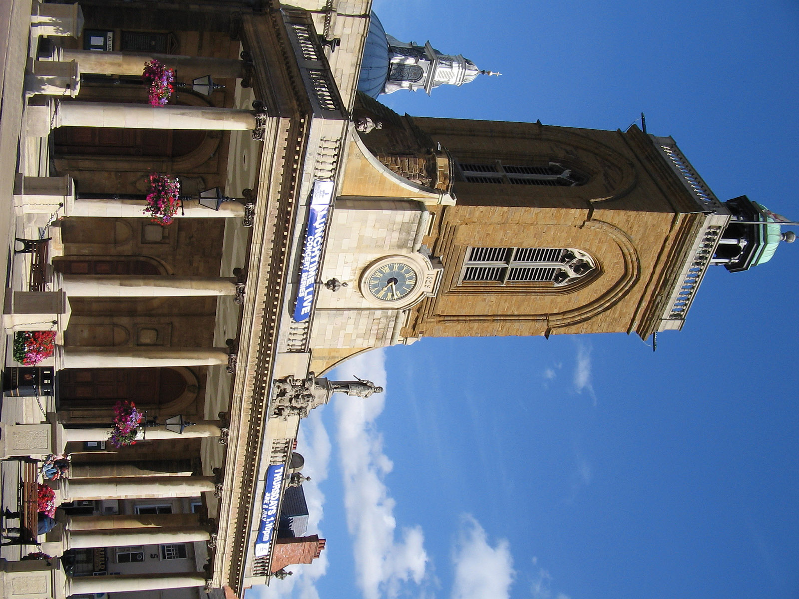

Northampton's oldest standing building, The Holy Sepulchre, is one of the largest and best-preserved round churches in England. It was built in 1100 on the orders of the first Earl of Northampton, Simon de Senlis and based on a plan of the original Church of the Holy Sepulchre in Jerusalem.[90]
Simon de Senlis also built Northampton Castle c. 1084, which was for many years one of the country's most important castles. It was a royal residence, held The Parliament of England many times, and was the site of royal tournaments and feasts. Thomas Becket was imprisoned there until he escaped. The castle suffered many fates and was eventually demolished for the railway station. A postern, dismantled from its original position and rebuilt into a wall by the station, and a part of the keep mound are all that remains.
The current All Saints' Church was built on the site of a great Norman church, All Hallows, which was almost completely destroyed by the Great Fire of Northampton in 1675. All that remained was the medieval tower and the fine vaulted crypt, but by 1680 All Saints had been rebuilt, with the help of donations from all over England, including 1,000 tons of timber from King Charles II, whose statue can be seen above the portico. Famously, the poet John Clare liked to sit beneath the portico of the church. It is home to a choral foundation, with choral services sung three times a week by one of its choirs, who also record commercially and tour throughout the world.

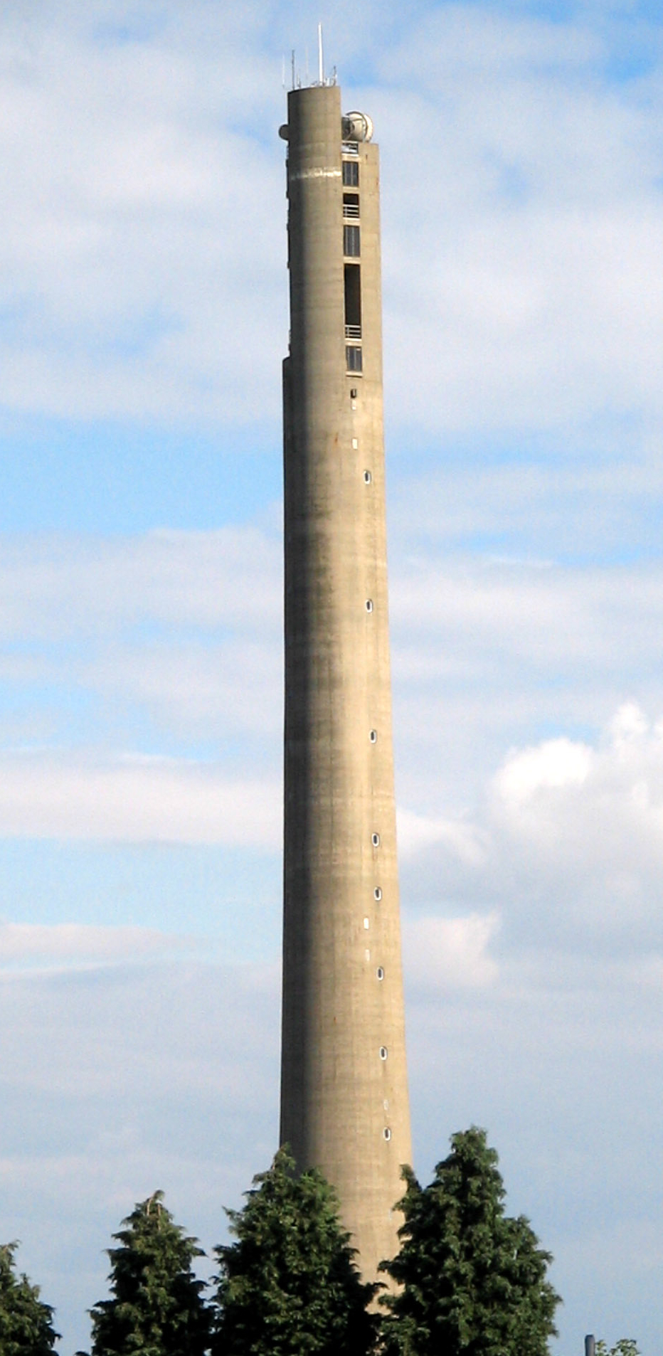
The Express Lift Tower is a prominent feature of the town's skyline
Other notable church buildings include Northampton Cathedral, the mother church of the Roman Catholic Diocese of Northampton and seat of the Bishop of Northampton; St Edmunds, which closed in 1978 and was demolished in 2007 (its bells are now in Saint Paul's Cathedral, Wellington); St Giles Church; St Matthew's in Phippsville, which was built between 1891-4, has a Henry Moore sculpture of the Madonna.
Just south of the town centre Delapré Abbey, a former Cluniac nunnery, the County Records Office and site of the second Battle of Northampton, which was founded by Simon II de Senlis, the son of first Earl of Northampton, in 1145. At the edge of the Abbey, one of the three standing Eleanor crosses still remains, in memory of Eleanor of Castile, whose body rested here on its way to London. The original top of the monument has been knocked off and replaced several times from as early as 1460.[91]
St Andrew's Hospital, which opened 1838, and its new building William Wake House, is one of the largest neo-classical structures in England. Northampton & County Club, which was established in 1873, was also the old county hospital before becoming a private members' club; the cellars are medieval. Northampton Guildhall, which is Grade II* listed, was constructed mostly in the 1860s in Victorian Gothic architecture designed by Edward William Godwin, and extended in the 1990s.
78 Derngate is a Grade II* listed Georgian Town House remodelled by Charles Rennie Mackintosh for Wenman Joseph Bassett-Lowke in 1916–17. It contains notable Mackintosh interiors (which have been restored) and is his only major domestic commission outside Scotland. It is open to the public.
The 127.45 m (418 ft 2 in) tall Express Lift Tower is a dominant feature and visible from most of the town. A Terry Wogan radio phone-in during the 1980s came up with the name "Northampton Lighthouse" as Northampton is one of the farthest places from the sea. It is also known as the "Cobblers' Needle". It was built for testing new lifts at the Express Lifts factory, now closed. Though now redundant, it is a listed building.
The former Greyfriars bus station served the town from 1976 until 2014. In the 2000s, it was featured on Channel 4's Demolition programme as the ugliest transport station in the United Kingdom and worthy of demolition. Demolition work began in March 2014, following the move of bus services to North Gate bus station. The Greyfriars was completely destroyed on 15 March 2015 by way of a controlled explosion.[92]
Transport[]

Northampton is near junctions 15, 15a and 16 of the M1 motorway which connects Northampton with London at its most southern point and Leeds at its most northern. Both the A45 and A43 link Northampton with the other major towns in Northamptonshire, and can be accessed by a partially completed ring road. The A14 is close by to the north of Northampton, providing links east and west of the town.
Northampton railway station is on the Northampton Loop of the West Coast Main Line, and has services southbound to London and northbound to Birmingham and Crewe provided by London Midland. Virgin Trains also provide two daily services to London.
Sywell Aerodrome is the nearest airfield which has recently been upgraded with a 1,000-metre-long (3,300 ft) concrete runway, however it only caters for private flying, flight training and corporate flights.[93] For international links, the East Midlands Airport and Luton Airport are quickly accessible by the M1; Birmingham Airport is also just north of the town via the M1 and M6 motorways and also by train.
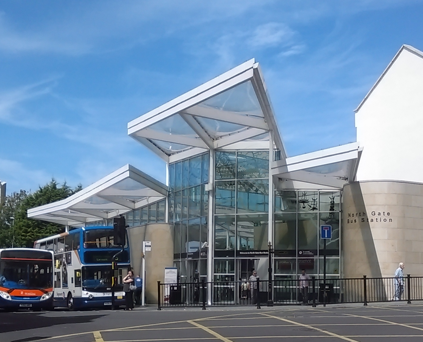
In the town, buses are mainly operated by Stagecoach from the North Gate bus station with some services from Uno. Stagecoach serves areas within the town and also provides travel to outlying villages and towns within the county, making links to Corby, Daventry, Kettering, Rushden and Wellingborough. They also go as far afield as Bedford, Bicester, Leicester, Market Harborough, Milton Keynes, Peterborough and Rugby. National Express also operates in Northampton, covering routes between major towns and cities in the United Kingdom.
Northampton is the terminus of an arm of the Grand Union Canal. The arm connects to the River Nene and from that to the River Great Ouse and the North Sea. No longer used for freight, the waterway is now popular with anglers and narrowboaters. Principal outlying villages on the canal include Gayton, Blisworth, Braunston and Stoke Bruerne.
Northampton once had a horse-drawn tramway which opened in 1881. The system was extended in stages and taken over by the council in 1897 and named Northampton Corporation Tramways. It was electrified in 1904, but closed in 1934 mainly as a result of competition from motor buses which were introduced in 1929. Two of the original tram shelters are preserved: one at the Racecourse park and another in Kingsthorpe opposite the Cock Hotel.[94]
Education[]


The University of Northampton is spread across two campuses; Avenue Campus entrance opposite the Racecourse
The first University of Northampton was established by royal charter by King Henry III in 1261,[95] and started to rival the universities in Cambridge and Oxford, with their students migrating to the Northampton establishment.[96] This university was dissolved by King Henry III in 1265, in revenge of its students siding with the rebellious barons in the Battle of Northampton (1264).[97] Henry III was also advised by bishops and magnates that it posed a threat to Oxford, and signed a Royal Decree which banned the establishment of a university in Northampton.[98]
This was eventually repealed and the university's name was revived in 2005 when the unconnected University College Northampton, which was founded in 1924, was upgraded to full university status and renamed the University of Northampton.[99] This is the only higher education (HE) establishment in the town and offers courses from foundation and undergraduate levels to postgraduate, professional and doctoral qualifications. The university is made of up six schools: Business, Education, Health, Science and Technology, Social Sciences and The Arts. The university is currently spread over two campuses across the town, but a new £330 million development will see the university move to one new waterside campus by the River Nene in the town centre by 2018.[100]
Northampton's only further education (FE) college is Northampton College, one of the largest FE colleges in the South Midlands, which has two campuses across the town, offering vocational courses, GCSEs and A Levels. Moulton College is another FE college just north of Northampton which provides many vocational courses, specialising in land-based subjects, sports and construction. In collaboration with the University of Northampton, both colleges also offer some HE programmes.
There are 50 primary schools and 8 secondary schools in the town. Until 2004, Northamptonshire operated a three-tier system in education of lower, middle and upper schools. In 2001, the move to a two-tier system to primary and secondary schools began, aimed at improving educational standards.[101] Some of its successful secondary schools include Northampton School for Boys, which became the top performing comprehensive school in the country in 2007,[102] and Northampton School for Girls, the first school in England to gain Specialist Music College status.[103] An average of 55% of students in Northampton achieved five A*-C grades at GCSE in 2015, above the government's benchmark of 40%.[104] There are also 5 special schools in the town and many independent schools including Bosworth Independent College, Northampton High School and Quinton House School. Overstone Park School, Pitsford School and Spratton Hall School are just north of Northampton.
Notable residents[]
Twin towns[]
Northampton is twinned with:[105]
See also[]
- Districts of Northampton
- Flooding in Weedon Road, St James and Far Cotton around Easter 1998
- Grade I listed buildings in Northampton
- Grade II* listed buildings in Northampton
- HMS Laforey
- Northampton Corporation Tramways
- Royal & Derngate
- St Peter's Church, Northampton
References[]
- ^ "Britain's 20 biggest towns". The Daily Telegraph (London). 18 August 2011. http://www.telegraph.co.uk/culture/tvandradio/8705932/Britains-20-biggest-towns.html.
- ^ http://www.theguardian.com/cities/datablog/2015/jan/19/uk-cities-ranked-jobs-migration-house-prices-broadband-speeds-data
- ^ a b c d e f g h i j k l m n o p The borough of Northampton - Introduction | A History of the County of Northampton: Volume 3 (pp. 1-26). British-history.ac.uk (23 September 1913). Retrieved on 17 July 2013.
- ^ a b c d "NORTHAMPTON | As described in John Marius Wilson's Imperial Gazetteer of England and Wales (1870-72)". Visionofbritain.org.uk. http://www.visionofbritain.org.uk/descriptions/entry_page.jsp;jsessionid=445DFDCCA215340BB5C3C71703542FC1?text_id=977650&word=NULL. Retrieved 29 August 2013.
- ^ "Charles II, 1675 - An Act for the better and more easy rebuilding the Towne of Northampton. | Statutes of the Realm: volume 5 (pp. 798-801)". British-history.ac.uk. 22 June 2003. http://www.british-history.ac.uk/report.aspx?compid=47460. Retrieved 29 August 2013.
- ^ Deegan, Alison. "Late Bronze Age, Iron Age and Roman settlements and landscapes". english-heritage.org.uk. http://www.english-heritage.org.uk/publications/mapping-ancient-landscapes-northamptonshire/mapping-ancient-landscapes-in-northamptonshire-chp6-7.pdf. Retrieved 12 September 2013.
- ^ "3500 BC: First Settlements at Briar Hill". Northamptonshire Timeline. http://www.northamptonshiretimeline.com/scene/3500bc-briar-hill/. Retrieved 17 July 2013.
- ^ "400 BC: Hillfort Begun at Hunsbury Hill in Northampton". Northamptonshire Timeline. http://www.northamptonshiretimeline.com/scene/400bc-hunsbury-hillfort/. Retrieved 17 July 2013.
- ^ Doyle, Tony. "Roman remains". Paintedpixels.co.uk. http://paintedpixels.co.uk/northampton/northampton/roman.html. Retrieved 29 August 2013.
- ^ Vince, Alan. "An Archaeological Resource Assessment and Research Agenda for the Early and Middle Anglo-Saxon Period (c. 400-850) in the East Midlands". le.ac.uk. http://www.le.ac.uk/ulas/publications/documents/emidas_000.pdf. Retrieved 12 September 2013.
- ^ The Liber Vitae of the New Minster, Winchester, Stowe 944(Fl.964-1030AD)
- ^ William George Searle, Onomasticon Anglo-Saxonicum: A List of Anglo-Saxon Proper Names from the Time of Beda to that of King John (Cambridge University Press, 22 March 2012), page 387
- ^ a b c "Northampton". historyofparliamentonline.org. http://www.historyofparliamentonline.org/volume/1386-1421/constituencies/northampton#constituency-main-article. Retrieved 12 September 2013.
- ^ a b c d e f g h i j k l m n o p q r s t u v w x y z aa ab ac ad ae af ag ah Andrew, Martin: Northampton The Francis Frith Collection, 2002
- ^ "Underground Northampton". Bbc.co.uk. 16 April 2009. http://www.bbc.co.uk/northamptonshire/content/articles/2009/04/03/underground_northampton_tunnels_feature.shtml. Retrieved 29 August 2013.
- ^ "''Mayors of Northampton'' W N Terry Central Art Gallery, Northampton, updated June 2011, accessed 5 October 2012". Google.co.uk. https://www.google.co.uk/webhp?source=search_app#hl=en&sugexp=les%3B&gs_nf=1&cp=21&gs_id=2d&xhr=t&q=mayors+of+northampton&pf=p&sclient=psy-ab&oq=Mayors+of+Northamptom&gs_l=&pbx=1&bav=on.2,or.r_gc.r_pw.r_qf.&fp=34d01fe90270ff60&biw=1920&bih=951. Retrieved 29 August 2013.
- ^ "Jewish Communities and Records". Jewishgen.org. http://www.jewishgen.org/jcr-uk/susser/thesis/thesischapterone.htm. Retrieved 29 August 2013.
- ^ Northampton synagogue discovered under kebab shop Jewish Chronicle – Marcus Dysch – 15 April 2010 TheJC.com
- ^ a b [1] Archived June 3, 2015 at the Wayback Machine.
- ^ a b c "The borough of Northampton - Description | A History of the County of Northampton: Volume 3 (pp. 30-40)". British-history.ac.uk. http://www.british-history.ac.uk/report.aspx?compid=66254. Retrieved 29 August 2013.
- ^ "Timeline | History of the Northampton Market Square | Northampton Borough Council". Northampton.gov.uk. 7 December 2011. http://www.northampton.gov.uk/info/200242/market/1144/history_of_the_northampton_market_square. Retrieved 29 August 2013.
- ^ "More Information". The Northamptonshire Timeline. http://www.northamptonshiretimeline.com/scene/1675reets-great-fire-of-northampton/. Retrieved 29 August 2013.
- ^ "1678 AD: Sessions House and County Hall in George Row Completed - More Information | Tudors & Stuarts". The Northamptonshire Timeline. http://www.northamptonshiretimeline.com/scene/1678-sessions-house/. Retrieved 29 August 2013.
- ^ Wadsworth, Alfred P.; Mann, Julia De Lacy (1931). The Cotton Trade and Industrial Lancashire, 1600-1780. Manchester: Manchester University Press. https://books.google.co.uk/books?id=5NVRAQAAIAAJ&pg=PA433.
- ^ "Parliamentary accounts and papers". UK Parliament. 23 July 1847. https://archive.org/stream/parliamentarypa98commgoog/parliamentarypa98commgoog_djvu.txt. Retrieved 9 December 2015.
- ^ Leleux (1984), p. 54.
- ^ Harrison, Chaz (11 August 2009). "Ever wondered what lies beneath?". BBC News. http://news.bbc.co.uk/local/northampton/hi/people_and_places/history/newsid_8195000/8195170.stm. Retrieved 30 August 2010.
- ^ Building Design Partnership (November 2006). "Northampton Central Area Design, development and movement framework (Final Report)" (PDF). para. 2.15. http://www.northampton.gov.uk/downloads/NPTONCentralArea1-21.pdf. Retrieved 30 August 2010.
- ^ Quick (2009), p. 295.
- ^ Leleux (1984), p. 56.
- ^ Butt (1995), p. 173.
- ^ Coleman and Rajczonek, Richard and Joe. Steaming into Northamptonshire. Northampton: Northamptonshire Libraries. ISBN 0 905391 1 2 8.
- ^ Coleman and Rajczonek, Richard and Joe (1987). Steam Nostalgia around Northampton. Northampton: Northamptonshire Libraries. ISBN 0 905391 11X.
- ^ Kingscott (2008), p. 70.
- ^ a b "Fifty years since a plan that transformed Northampton". BBC News. 3 February 2015. http://www.bbc.co.uk/news/uk-england-northamptonshire-31110173.
- ^ "Millennium city leak angers bookies". BBC. 7 March 2000. http://news.bbc.co.uk/1/hi/uk/669580.stm. Retrieved 15 October 2008.
- ^ "City winners named". BBC. 18 December 2000. http://news.bbc.co.uk/1/hi/uk/1074434.stm. Retrieved 15 October 2008.
- ^ http://news.bbc.co.uk/1/hi/uk_politics/1872577.stm
- ^ West Northamptonshire Development Corporation website. Wndc.co.uk. Retrieved on 25 August 2011.
- ^ http://www.northamptonchron.co.uk/news/local/northampton-s-st-giles-street-wins-high-street-of-the-year-in-national-competition-1-7092537
- ^ "District Councils and Boroughs". Hansard 1803–2005. Parliament of the United Kingdom. 28 March 1974. http://hansard.millbanksystems.com/written_answers/1974/mar/28/district-councils-and-boroughs#S5CV0871P0_19740328_CWA_145. Retrieved 16 January 2012.
- ^ "Table III(a)". Local Government in England and wales. a Guide to the New System.. London: HMSO. 1974. pp. 15–109. ISBN 0117508470.
- ^ "City winners named". BBC News. 18 December 2000. http://news.bbc.co.uk/1/hi/uk/1074434.stm. Retrieved 2 April 2008.
- ^ "BBC News - Northampton Borough Council unitary authority bid defeated". Bbc.co.uk. 6 December 2011. http://www.bbc.co.uk/news/uk-england-northamptonshire-16055929. Retrieved 29 August 2013.
- ^ http://northamptonchron.co.uk/news/local/mps-call-for-eight-councils-in-northants-to-be-scrapped-and-replaced-with-unitary-authorities-1-7253820
- ^ http://www.northampton-news-hp.co.uk/political-groups-Northampton-agree-draw-plans/story-28880002-detail/story.html
- ^ "My Council". northampton.gov.uk. http://selfserve.northampton.gov.uk/mycouncil/. Retrieved 12 September 2013.
- ^ "Parish Councils in Northampton | Other Councils | Northampton Borough Council". Northampton.gov.uk. http://www.northampton.gov.uk/info/200033/councillors_and_democracy/480/other_councils. Retrieved 29 August 2013.
- ^ a b "Moulton Park Weather". http://www.northampton.ac.uk/appliedsciences/appliedscience/geoenvsci/climatological-station/temperature. Retrieved 23 February 2011.
- ^ "19th July 2006". http://www.metoffice.gov.uk/climate/uk/interesting/july2006/MaxTemp1907Points_jpeg.JPG. Retrieved 23 February 2011.
- ^ Rogers, Simon (21 December 2010). "20 December 2010". The Guardian (London). http://www.guardian.co.uk/news/datablog/2010/dec/20/winter-weather-coldest-places-britain. Retrieved 23 February 2011.
- ^ "Climate Normals 1981-2010". Met Office. November 2012. http://www.metoffice.gov.uk/public/weather/climate/northampton-moulton-park#?tab=climateTablesl. Retrieved 29 November 2012.
- ^ "Climate Normals 1971–2000". YR.NO. August 2011. http://www.yr.no/place/United_Kingdom/England/Moulton~2642124/statistics.html. Retrieved 23 February 2011.
- ^ "Long term Rainfall". WorldClimate. http://www.worldclimate.com/cgi-bin/data.pl?ref=N52W000+2100+0355801G1. Retrieved 23 February 2011.
- ^ "1991 Census, Northamptonshire Observatory". http://www.northamptonshireobservatory.org.uk/dataexplorer/dataset.asp?datasetid=612&subsetid=1383&subjectid=. Retrieved 3 July 2013.
- ^ a b "2001,2011 Census's, ONS". http://www.neighbourhood.statistics.gov.uk/dissemination/LeadSByASelectScotNI.do?a=7&c=NORTHAMPTONSHIRE&d=20&i=1001x1002&o=362&m=0&r=1&s=1372873585344&enc=1&areaId=6059426&OAAreaId=472090. Retrieved 3 July 2013.
- ^ "Residents Mean age". http://www.neighbourhood.statistics.gov.uk/dissemination/LeadTableView.do?a=7&b=6275190&c=NORTHAMPTON&d=13&e=62&g=6451666&i=1001x1003x1032x1004&o=362&m=0&r=1&s=1373503752603&enc=1&dsFamilyId=2474. Retrieved 11 July 2013.
- ^ "2011 Census Key Statistics". http://www.neighbourhood.statistics.gov.uk/dissemination/LeadKeyFigures.do?a=7&b=6275190&c=NORTHAMPTON&d=13&e=62&g=6451666&i=1001x1003x1032x1004&o=362&m=0&r=1&s=1373503752603&enc=1. Retrieved 11 July 2013.
- ^ "2011 Census Household type". http://www.neighbourhood.statistics.gov.uk/dissemination/LeadTableView.do?a=7&b=6275190&c=NORTHAMPTON&d=13&e=62&g=6451666&i=1001x1003x1032x1004&o=362&m=0&r=1&s=1373503752603&enc=1&dsFamilyId=2489. Retrieved 11 July 2013.
- ^ "2011 Census Household tenure". http://www.neighbourhood.statistics.gov.uk/dissemination/LeadTableView.do?a=7&b=6275190&c=NORTHAMPTON&d=13&e=62&g=6451666&i=1001x1003x1032x1004&o=362&m=0&r=1&s=1373503752603&enc=1&dsFamilyId=2482. Retrieved 11 July 2013.
- ^ "2011 Census Transport". http://www.neighbourhood.statistics.gov.uk/dissemination/LeadTableView.do?a=7&b=6275190&c=NORTHAMPTON&d=13&e=62&g=6451666&i=1001x1003x1032x1004&o=362&m=0&r=1&s=1373503752603&enc=1&dsFamilyId=2483. Retrieved 11 July 2013.
- ^ "2012 incomes". http://www.ons.gov.uk/ons/rel/ashe/annual-survey-of-hours-and-earnings-pension-tables/2012-provisional-results/index.html. Retrieved 11 July 2013.
- ^ "2011 Census, Religion". http://www.neighbourhood.statistics.gov.uk/dissemination/LeadTableView.do?a=7&b=6275190&c=NORTHAMPTON&d=13&e=62&g=6451666&i=1001x1003x1032x1004&o=362&m=0&r=1&s=1373504926275&enc=1&dsFamilyId=2479. Retrieved 11 July 2013.
- ^ Wildsmith: The History of our Footwear
- ^ Church's English Shoes. Church-footwear.com. Retrieved on 25 August 2011.
- ^ a b "RE Trickers Limited". http://www.trickers.com/. Retrieved 21 May 2008.
- ^ '' 'Avon New European HQ to Open Autumn 2009' '' Northampton Chronicle & Echo report. Northamptonchron.co.uk. Retrieved on 25 August 2011.
- ^ Avon cease manufacturing in Northampton – BBC report 2003. BBC News (17 April 2003). Retrieved on 25 August 2011.
- ^ Extract from Building Societies Yearbook 2009/10 (p.127) Building Societies Association (Retrieved 17 November 2009)
- ^ Simply Business poised for growth after MBO. Insider Media (19 July 2013). Retrieved on 30 July 2013.
- ^ English Partnerships. English Partnerships. Retrieved on 25 August 2011.
- ^ 'Princess Benedikte of Denmark visits Carlsberg brewery' BBC
- ^ 'And the business capital of the UK is...' The Telegraph, 6 March 2014
- ^ 'Abington Street is screaming out for improvements.' - Features - Northampton Chronicle and Echo, 6 June 2005, accessed 16 April 2015.
- ^ "Parks and Open Spaces | Northampton Borough Council". Northampton.gov.uk. 19 March 2009. http://www.northampton.gov.uk/parks. Retrieved 29 August 2013.
- ^ Harry, Bill (2000). The Beatles Encyclopaedia (2000 paperback edition; first published 1992). London: Virgin Publishing, London W6 9HA. pp. 9 and 776. ISBN 0-7535-0481-2.
- ^ http://www.northamptonshire.gov.uk/en/news/Newsreleases/Pages/2433.aspx
- ^ http://www.northamptonshire.gov.uk/en/councilservices/leisure/libraries/visit-your-library/listlibraries/pages/listoflibraries.aspx
- ^ "Sekhemka statue: Northampton Museum loses Art Council accreditation". BBC News. 1 August 2014. http://www.bbc.co.uk/news/uk-england-northamptonshire-28602849.
- ^ [2]
- ^ BBC News - Northampton arts collective to move to cultural quarter BBB.co.uk 2012-02-07 Retrieved 17 July 2013.
- ^ The Portfolio Innovation Centre. Portfoliocentre.co.uk. Retrieved on 25 August 2011.
- ^ Open Studios. Open Studios. Retrieved on 25 August 2011.
- ^ a b Northampton Old Scouts RFC. Nosrfc.com. Retrieved on 25 August 2011.
- ^ "Ben Cohen joined celebrations with the Northampton Outlaws RFC :: The Ben Cohen StandUp Foundation". Standupfoundation.com. http://www.standupfoundation.com/standup-news/ben-cohen-joined-the-celebrations-with-the-northampton-outlaws-rfc/. Retrieved 29 August 2013.
- ^ "World Association of Newspapers". http://www.wan-press.org/article2823.html. Retrieved 30 August 2009.
- ^ "Ofcom press release 24 July 2008". Ofcom website. http://www.ofcom.org.uk/media/news/2008/07/nr_20080724a.
- ^ "Supergran? No, I'm just a mad old woman with a handbag, says Ann, who foiled an armed gang". Daily Mail (London). 11 February 2011. http://www.dailymail.co.uk/news/article-1356155/Supergran-Ann-Timson-foiled-armed-gang-handbag-says-shes-just-mad.html.
- ^ http://www.dailystar.co.uk/news/latest-news/339629/Creepy-Northampton-clown-who-became-internet-sensation-only-means-harmless-fun
- ^ http://www.bbc.co.uk/northamptonshire/content/articles/2007/06/19/church_of_the_holy_sepulchre_feature.shtml
- ^ Hardingstone Eleanor Cross:: OS grid SP7558 :: Geograph Britain and Ireland – photograph every grid square!. Geograph.org.uk. Retrieved on 25 August 2011.
- ^ "Northampton Greyfriars bus station demolished". BBC News. 15 March 2015. http://www.bbc.co.uk/news/uk-england-northamptonshire-31895351.
- ^ Sywell Aerodrome – new concrete runway to open. Northamptonchron.co.uk. Retrieved 25 August 2011.
- ^ "Trams". Far Cotton History Group. http://cottonites.co.uk/transport.htm. Retrieved 7 October 2009.
- ^ Arthur F. Leach (31 October 2010). Educational Charters and Documents 598 to 1909. Cambridge University Press. pp. 158–. ISBN 978-1-108-01016-0. https://books.google.com/books?id=YlQHi9LKefEC&pg=PA158. Retrieved 31 August 2013.
- ^ "Reading, a city dreaming of spires | General". Times Higher Education. 3 May 1996. http://www.timeshighereducation.co.uk/93509.article. Retrieved 29 August 2013.
- ^ Alan Cobban (4 January 2002). English University Life In The Middle Ages. Taylor & Francis. pp. 194–. ISBN 978-0-203-00651-1. https://books.google.com/books?id=KBYC9aDw7zoC&pg=PA194. Retrieved 31 August 2013.
- ^ "Northamptonshire - Students - Northampton regains University status". BBC. http://www.bbc.co.uk/northamptonshire/content/articles/2005/10/22/student_news_uni_official_feature.shtml. Retrieved 29 August 2013.
- ^ "University of Northampton considering plans to move to new site - Politics - Northampton Chronicle and Echo". Northamptonchron.co.uk. 17 April 2012. http://www.northamptonchron.co.uk/news/politics/university-of-northampton-considering-plans-to-move-to-new-site-1-3739420. Retrieved 29 August 2013.
- ^ http://www.northampton-news-hp.co.uk/University-Northampton-s-new-330m-Waterside/story-28035446-detail/story.html
- ^ – Education – Parents' concern over school closures. BBC News (28 June 2001). Retrieved on 25 August 2011.
- ^ "Five-star performance by NSB's A-level students". Newspaper (Chronicle & Echo). 14 August 2008. Archived from the original on 19 May 2010. http://www.webcitation.org/5ppXebos3. Retrieved 12 October 2008.
- ^ Woodthorpe, David (10 February 2006). "East: Education, education ...". BBC. http://news.bbc.co.uk/1/hi/programmes/politics_show/4696116.stm. Retrieved 22 August 2008.
- ^ http://www.northamptonchron.co.uk/news/local/caroline-chisholm-tops-northampton-school-league-tables-but-two-schools-fell-below-floor-standard-1-7173301
- ^ Scott, Sophie (2 November 2012). "Team's celebration with German 'twin'". Northampton Hearld and Post. http://www.northampton-news-hp.co.uk/News/Northampton-News/Teams-celebration-with-German-twin-01112012.htm. Retrieved 6 September 2013.
External links[]
| Wikivoyage has a travel guide for Northampton. |
- Northampton Borough Council
- Northamptonshire County Council
- Love Northampton
- The University of Northampton
- Northampton College
- Northamptonshire Healthcare NHS Foundation Trust
- Northampton Chronicle & Echo
- 1950s Ordnance Survey Maps of the town and the website of 1950s Delapre resident now living in New York
Template:Northampton
| ||||||||||||||||||||
| |||||
| |||||
|
| This page uses content from the English language Wikipedia. The original content was at Northampton. The list of authors can be seen in the page history. As with this Familypedia wiki, the content of Wikipedia is available under the Creative Commons License. |