| Main | Births etc |
|---|
{| class="infobox geography bordered" style="font-size: 95%; width: 22em;"
|- |colspan=2 align=center bgcolor="#BFDFFF"|Northland Regional Council |- |Country: || New Zealand |-
|colspan=2 style="text-align: center"|
|- !colspan=2 style="background: #BFDFFF; text-align: center"|Regional Council |- |Name:||Northland Regional Council |- |Chair:||Craig Brown |- |Deputy Chair:||John Bain |- |Population:||158,300 June 2012 estimate [1] |- |Land Area:||13,789 km² |- |Indigenous Iwi:|| Ngāi Takoto, Ngā Puhi, Ngāti Whātua, Ngāti Kahu, Ngāti Kurī, Ngāti Wai, Te Aupōuri, Te Rarawa Te Roroa |- |Website:||http://www.nrc.govt.nz |- !colspan=2 style="background: #BFDFFF; text-align: center"|Cities and Towns |- |Cities:||Whangarei |- |Towns:||Kaitaia, Kaeo, Kawakawa, Moerewa, Kaikohe, Ohaeawai, Okaihau, Kerikeri, Russell, Paihia, Waitangi, Mangonui, Taipa, Donnelly's Crossing, Opononi, Omapere, Rawene, Kohukohu, Ruakaka, Waipu, Kaiwaka, Mangawhai, Dargaville, Ruawai, Maungaturoto, Paparoa. |- !colspan=2 align=center bgcolor="#BFDFFF"|Constituent Territorial Authorities |- |Names:||Far North District, Kaipara District, Whangarei District |- |Websites:||http://www.fndc.govt.nz, http://www.kaipara.govt.nz, http://www.wdc.govt.nz, |- |}

A map showing population density in the Northland Region at the 2006 census.
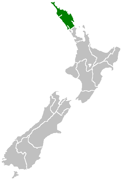
The Northland Region (Māori: Te Tai-tokerau, also Te Hiku-o-te-Ika, 'the Tail of the Fish (of Maui)'), one of the 16 regions of New Zealand, is, as the name suggests, the northernmost of New Zealand's administrative regions. The main centre is the city of Whangarei.
Geography
Northland is located in what is often referred to by New Zealanders as the Far North, or, because of its mild climate, The Winterless North. It occupies the upper 80% of the 285 kilometre-long North Auckland Peninsula, the southernmost part of which is in the Auckland Region.[2]
Stretching from a narrowing of the peninsula close to the town of Wellsford, Northland extends north to the tip of the North Auckland Peninsula, covering an area of 13,940 km², a little over five per cent of the country's total area. It is bounded to the west by the Tasman Sea, and to the east by the Pacific Ocean. The land is predominantly rolling hill country. Farming and forestry occupy over half of the land, and are two of the region's main industries.[2]
Although many of the region's kauri forests were felled during the 19th century, some areas still exist where this rare giant grows tall. New Zealand's largest tree, Tane Mahuta, stands in the Waipoua Forest south of the Hokianga Harbour.
The western coast of the region is dominated by several long straight beaches, the most famous of which is the inaccurately named 88 kilometre-long stretch of Ninety Mile Beach in the region's far north. Two large inlets are also located on this coast, the massive Kaipara Harbour in the south, which Northland shares with the Auckland Region, and the convoluted inlets of the Hokianga Harbour.
The east coast is more rugged, and is dotted with bays and peninsulas. Several large natural harbours are found on this coast, from Parengarenga close to the region's northern tip, past the famous Bay of Islands down to Whangarei Harbour, on the shores of which is situated the region's largest population centre. Numerous islands dot this coast, notably the Cavalli Islands, the Hen and Chickens Islands, Aorangaia Island and the Poor Knights Islands.
The northernmost points of the North Island mainland lie at the top of Northland. These include several points often confused in the public mind as being the country's northernmost points: Cape Maria van Diemen, Spirits Bay, Cape Reinga, and North Cape. The northernmost point of the North Island is actually the Surville Cliffs, close to North Cape, although the northernmost point of the country is further north in the Kermadec chain of islands. Cape Reinga and Spirits Bay do, however, have a symbolic part to play as the end of the country. In Māori mythology, it is from here that the souls of the dead depart on their journey to the afterlife.
Climate
The region of Northland has a sub-tropical oceanic climate with warm humid summers and mild wet winters. Due to its latitude and low elevation, Northland has the country's highest average annual temperature.[3] However, as with other parts of New Zealand, climate conditions are variable. In summer, temperatures range from 22 °C to 26 °C, occasionally rising above 30°C. In winter, maximum temperatures vary between 14 °C and 20 °C.[4]
Ground frosts are rare due to the region being encircled by the moderating Pacific and Tasman waters; however light frosts do occur infrequently around Dargaville in the lowlands.[3] The hottest months are January and February due to the presence of an El Niño pressure system. In January 2009, excessive sunlight hours and below-average rainfall resulted in the region being declared a drought zone.[5]
Typical annual rainfall for the region is 1500–2000 mm but varies at different altitudes. Due to its northerly location, Northland has an average of 2000 sunshine hours annually.[6] Winds are predominantly from the southwest. Occasionally in summer, the region experiences stormy conditions from former cyclones which generally become much weaker once they leave tropical latitudes.[4]
Administration
The seat of the Northland Regional Council is in Whangarei. There are three territorial authorities in the Northland region:
- Far North District Council, based in Kaikohe
- Whangarei District Council
- Kaipara District Council, based in Dargaville
Population

Kauri tree Agathis australis.
Northland is New Zealand's least urbanised region, with 50% of the population of 158,300 living in urban areas. Of these areas, Whangarei is the largest, with a population of 52,500 (June 2012 estimates).[1] Eight other centres have populations of over 1000: Russell, Kaitaia, Dargaville, Kaikohe, Paihia, Kerikeri, Taipa-Mangonui, and Kawakawa. The population is largely concentrated along the region's east coast. During the five year period up to 2006, Northland recorded a population growth of 6.0 percent, slightly below the national average. Northland includes one of the fastest growing towns in New Zealand, Mangawhai which is expanding rapidly due to residential and subsequent commercial development.
Māori refer to Northland — and by extension its Māori people — as Te Tai-tokerau (the northern tide) and Māori language and traditions are strong there.[7] The Māori population in the region was 43,530 according to the 2006 Census, or 7.7 percent of the total Māori population. Half were under the age of 23.4 years. Major tribal groups include Ngāpuhi, Te Aupōuri, Te Rarawa, Ngāti Kahu, Ngāti Kurī and Ngāti Whātua.[8]
Over the last 10 years Northland's population has defied national (and worldwide) trends by becoming increasingly rural. Approximately one third of the region's population are Māori, the majority of the remainder being of European lineage. Compared to the rest of the country Pacific Islanders are under-represented in Northland. Although most of the region's European population are of British stock (as is true with the rest of the country), certain other ethnicities have left their mark on the Northland racial mix. Of these the most influential have probably been the Dalmatian community from the Dargaville area north, with a particularly strong heritage around Kaitaia.
History

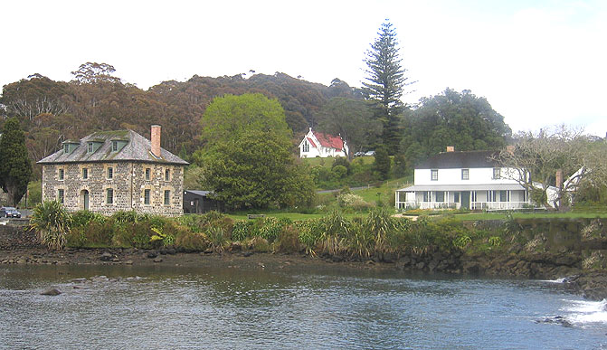
Kerikeri, Bay of Islands.
Stone Store at left, St James at rear, and Kemp House on the right.
According to Māori legend, the North Island of New Zealand was an enormous fish, caught by the adventurer Māui. For this reason, Northland sometimes goes by the nickname of "The tail of the fish", Te Hiku o Te Ika.
Northland iwi claim that Kupe made landfall at the Hokianga (although others claim this was at Taipa) in the northwest of Northland, and thus the region claims that it was the birthplace of New Zealand. Some of the oldest traces of Māori kainga (fishing villages), can be found here.
If the Māori regard the region as the legendary birthplace of the country, there can be no doubt that it was the European starting-point for the modern nation of New Zealand. Traders, whalers and sealers were among the first arrivals, and the gum and timber of the mighty kauri trees brought more colonisers.
Kerikeri in the Bay of Islands can lay claim to being the first permanent European settlement in New Zealand, and contains many historic buildings, including the Stone Store, New Zealand's oldest extant building.
The nearby settlement of Waitangi was of even more significance, as the signing place of New Zealand's founding document, the Treaty of Waitangi between the Māori tribes and the British Crown, on 6 February 1840.
Economy
The sub-national GDP of the Northland region was estimated at US$3.243 billion in 2003, 2% of New Zealand's national GDP.[9]
The region's economy is based on agriculture (notably beef cattle), fishing, forestry, and horticulture. Citrus fruit makes up the majority of the latter industry, with lemons, oranges, and tamarillos all being produced. Avocados are also widely grown, as well as kumara (especially in Ruawai part of the Kaipara district). Olives are also being grown on the Aupouri Peninsula.[10]
Extensive forests are a feature of the Northland landscape. For this reason wood and paper manufacturing industries also make a large contribution to the region's economy.[10]
Northland is a favourite tourist destination, especially to the Bay of Islands and the historic town of Kerikeri. Diving and fishing are also popular visitor activities, especially around the Bay of Islands and the Poor Knights island chain.
Northland is home to New Zealand's only oil refinery, at Marsden Point, close to Whangarei. New Zealand's natural fuel resources in Taranaki account for a little under half of the refinery's intake, with the rest coming predominantly from the Middle East. The nearby Marsden A thermal power station originally utilised heavy oil from the refinery for electricity production, but no longer does so.
References
- ^ a b "Subnational population estimates at 30 June 2012". Statistics New Zealand. 23 October 2012. http://www.stats.govt.nz/browse_for_stats/population/estimates_and_projections/subnational-pop-estimates-tables.aspx. Retrieved 23 October 2012. Also "Infoshare; Group: Population Estimates - DPE; Table: Estimated Resident Population for Urban Areas, at 30 June (1996+) (Annual-Jun)". Statistics New Zealand. 19 December 2012. http://www.stats.govt.nz/infoshare/SelectVariables.aspx?pxID=2f5a6aa2-7aeb-4792-a34a-d5567eb8082f. Retrieved 23 October 2012.
- ^ a b Orange, Claudia (2 March 2009). "Northland region - Geography". Te Ara Encyclopedia of New Zealand. http://www.teara.govt.nz/en/northland-region/2. Retrieved 15 February 2010.
- ^ a b "Living in Northland". Northland District Health Board. 2 March 2009. http://www.northlanddhb.org.nz/careers/living-in-Northland/climate/. Retrieved 15 February 2010.
- ^ a b Orange, Claudia (2 March 2009). "Northland region - Natural environment". Te Ara Encyclopedia of New Zealand. http://www.teara.govt.nz/en/northland-region/3. Retrieved 15 February 2010.
- ^ "Drought confirms Northland as NZ's hottest place in 2009". The Northland Advocate. 9 February 2010. http://www.northernadvocate.co.nz/local/news/drought-confirms-northland-as-nzs-hottest-place-in/3909758/. Retrieved 15 February 2010.
- ^ "NorthlandNZ - Climate". Destination Northland. http://www.northlandnz.com/about/climate/. Retrieved 15 February 2010.
- ^ Claudia Orange. 'Northland region - Overview', Te Ara - the Encyclopedia of New Zealand, updated 2-Mar-09 URL: Northland region - Overview, accessed 31 August 2011.
- ^ Te Puni Kōkiri/Ministry for Māori Development. 'Te Taitokerau'. URL: In your region: Te Taitokerau, accessed 31 August 2011.
- ^ "Regional Gross Domestic Product". Statistics New Zealand. 2007. http://www.stats.govt.nz/reports/analytical-reports/regional-gross-domestic-product.aspx. Retrieved 18 February 2010.
- ^ a b Orange, Claudia (2 February 2009). "Northland region - Farming and forestry". Te Ara Encyclopedia of New Zealand. http://www.teara.govt.nz/en/northland-region/9. Retrieved 15 February 2010.
External links
- Early births, marriages, and deaths] on Pearl's Pad
- The regional council's site
- Northland regional information web site.
- Northland in Te Ara the Encyclopedia of New Zealand
- This is the Place - Northland living history website
- The NZ Automobile Association's 101 Must-Do's for Northland Region
| ||||||||||||||
| This page uses content from the English language Wikipedia. The original content was at Northland Region. The list of authors can be seen in the page history. As with this Familypedia wiki, the content of Wikipedia is available under the Creative Commons License. |