| Oxford Township, Ohio | |
|---|---|
| — Township — | |
 |
|
| Coordinates: Coordinates: | |
| Country | United States |
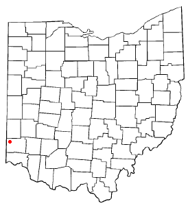
| State | Ohio |
| County | Butler |
| Area | |
| • Total | 37.3 sq mi (96.5 km2) |
| • Land | 36.9 sq mi (95.7 km2) |
| • Water | 0.3 sq mi (0.9 km2) |
| Elevation[1] | 909 ft (277 m) |
| Population (2000) | |
| • Total | 24,133 |
| • Density | 653.5/sq mi (252.3/km2) |
| Time zone | Eastern (EST) (UTC-5) |
| • Summer (DST) | EDT (UTC-4) |
| ZIP code | 45056 |
| Area code(s) | 513 |
| FIPS code | 39-59241[2] |
| GNIS feature ID | 1085817[1] |
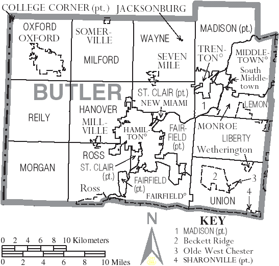
Oxford Township, also known as the College Township, is one of thirteen townships in the county and is located in the northwestern corner of Butler County, Ohio, United States, where it meets Preble County, Ohio, and Union County, Indiana. The city of Oxford and Miami University are located here. The Census Bureau counted 24,133 inhabitants in 2000, up from 23,092 in 1990. Excluding the city of Oxford and the village of College Corner there are 2,008 residents of the unincorporated portion of Oxford Township.[3] It comprises one full survey township (R1E T5) in the Congress Lands and is thirty-six square miles in area.
History[]
The eleventh in order of creation, Oxford Township was erected from Milford Township by the Butler County Commissioners (James Blackburn, William Robison, and John Wingate) on August 5, 1811, with these boundaries:
- So much of the township of Milford as lies within the following boundaries, to wit: Beginning at the northwest corner of the county of Butler; thence south with the western boundary line of the said county of Butler to the southwest corner of township numbered five in the first range east of the meridian line drawn from the mouth of the Great Miami river; thence east with the southern boundary line of the same township to the southeast corner thereof; thence north with the eastern boundary line thereof to the north boundary line of the said county of Butler; thence west with the same to the place of beginning.
The first election of township officers was held at Sylvester Lyons's house on August 24, 1811. When Butler County was originally divided into townships, this land was in St. Clair Township. The site was chosen by the State of Ohio for a college in order to fulfill the unkept promise of John Cleves Symmes. (See College Township for more details.)
Historic population figures[]
- 1820—1,653
- 1830—2,928
- 1840—3,388
- 1890—3,689
- 1900—3,766
- 1910—3,309
- 1920—3,678
- 1930—4,320
- 1940—4,685
- 1950—3,336
- 1960—4,081
- 1970—2,357
- 1980—4,058
- 1990—4,079
Geography[]
Located in the northwestern corner of the county, it borders the following townships:
- Israel Township, Preble County - north
- Somers Township, Preble County - northeast corner
- Milford Township - east
- Hanover Township - southeast corner
- Reily Township - south
- Springfield Township, Franklin County, Indiana - southwest corner
- Bath Township, Franklin County, Indiana - west
- Union Township, Union County, Indiana - northwest
Name[]
It is one of six Oxford Townships statewide.[4]
Government[]
The township is governed by a three-member board of trustees, who are elected in November of odd-numbered years to a four-year term beginning on the following January 1. Two are elected in the year after the presidential election and one is elected in the year before it. There is also an elected township fiscal officer,[5] who serves a four-year term beginning on April 1 of the year after the election, which is held in November of the year before the presidential election. Vacancies in the fiscal officership or on the board of trustees are filled by the remaining trustees.
Public services[]
Major highways in Oxford Township are U.S. Route 27 and State Routes 73 and 732. A part of Hueston Woods State Park is in the township and the highest point in Butler County, altitude 1,051 feet, is in Oxford Township. The township is in the Talawanda City and College Corner Local School Districts and the Oxford telephone exchange.
References[]
- Bert S. Barlow, W.H. Todhunter, Stephen D. Cone, Joseph J. Pater, and Frederick Schneider, eds. Centennial History of Butler County, Ohio. Hamilton, Ohio: B.F. Bowen, 1905.
- Jim Blount. The 1900s: 100 Years In the History of Butler County, Ohio. Hamilton, Ohio: Past Present Press, 2000.
- Butler County Engineer's Office. Butler County Official Transportation Map, 2003. Fairfield Township, Butler County, Ohio: The Office, 2003.
- A History and Biographical Cyclopaedia of Butler County, Ohio with Illustrations and Sketches of Its Representative Men and Pioneers. Cincinnati, Ohio: Western Biographical Publishing Company, 1882. [1]
- Ohio. Secretary of State. The Ohio municipal and township roster, 2002-2003. Columbus, Ohio: The Secretary, 2003.
- ^ a b "US Board on Geographic Names". United States Geological Survey. 2007-10-25. http://geonames.usgs.gov. Retrieved 2008-01-31.
- ^ "American FactFinder". United States Census Bureau. http://factfinder.census.gov. Retrieved 2008-01-31.
- ^ Butler County, Ohio — Population by Places Estimates Ohio State University, 2007. Accessed 15 May 2007.
- ^ "Detailed map of Ohio" (PDF). United States Census Bureau. 2000. http://www2.census.gov/geo/maps/general_ref/cousub_outline/cen2k_pgsz/oh_cosub.pdf. Retrieved 2007-02-16.
- ^ §503.24, §505.01, and §507.01 of the Ohio Revised Code. Accessed 4/30/2009.
External links[]
| |||||||||||||||||||||||

| This page uses content from the English language Wikipedia. The original content was at Oxford Township, Butler County, Ohio. The list of authors can be seen in the page history. As with this Familypedia wiki, the content of Wikipedia is available under the Creative Commons License. |