| Main | Births etc |
|---|
| Oyster Bay, New York | |
|---|---|
| — Town — | |
| Town of Oyster Bay | |
 |
|
 |
|

Oyster Bay, New York |
|
| Coordinates: Coordinates: | |
| Country | |
| State | |
| County | Nassau |
| Government | |
| • Type | Town Council |
| • Town Supervisor | John Venditto (R) |
| • Town Council | Members' List
|
| Area | |
| • Total | 169.5 sq mi (439.0 km2) |
| • Land | 104.4 sq mi (270.3 km2) |
| • Water | 65.1 sq mi (168.7 km2) |
| Elevation | 180 ft (55 m) |
| Population (2010) | |
| • Total | 293,214 |
| • Density | 2,826.2/sq mi (1,091.2/km2) |
| Time zone | Eastern (EST) (UTC-5) |
| • Summer (DST) | EDT (UTC-4) |
| ZIP code | 11771 |
| Area code(s) | 516 |
| FIPS code | 36-56000 |
| GNIS feature ID | 0979336 |
| Website | oysterbaytown.com |
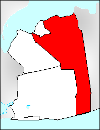

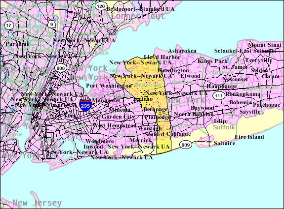
Map showing the Town of Oyster Bay in Nassau County: the town is bordered on the east by Suffolk County, on the southwest by the town of Hempstead, on the northwest by the town of North Hempstead and surrounds the city of Glen Cove
The Town of Oyster Bay is easternmost of the three towns in Nassau County, New York, in the United States. Part of the New York metropolitan area, it is the only town in Nassau County that extends from the North Shore to the South Shore of Long Island. As of the 2010 census, the town population was 293,214.
There are 18 villages and 18 hamlets within the town of Oyster Bay. The U.S. Postal Service has organized these 36 places into 30 different 5-digit ZIP codes served by 20 different post offices.[1] Each post office has the same name as a hamlet or village, but the boundaries are seldom the same.
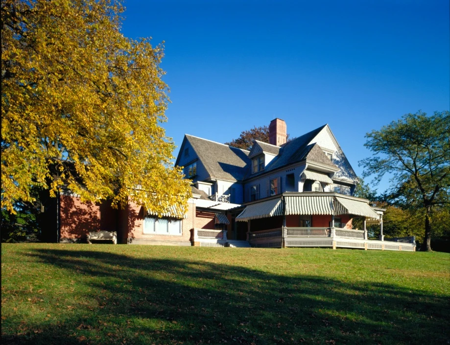
Oyster Bay is also the name of a hamlet on the north shore, within the town of Oyster Bay. Near this hamlet, in the village of Cove Neck, is Sagamore Hill, the former residence and summer White House of Theodore Roosevelt and now a museum. At least six of the 36 villages and hamlets of the town have shores on Oyster Bay Harbor, an inlet of Long Island Sound, and many of these at one time or another have also been referred to as being part of the hamlet of Oyster Bay.[2]
History[]


George Bradford Brainerd (American, 1845-1887). Camp Fire, Oyster Bay, Long Island, ca. 1872-1887. Collodion silver glass wet plate negative. Brooklyn Museum
Succeeding cultures of indigenous peoples had lived in the area for thousands of years. At the time of European contact, the Lenape (Delaware) nation inhabited western Long Island. By 1600 the band inhabiting the local area was called the Matinecock after their location, but they were Lenape people.
Following European colonization, the area became part of the colony of New Netherland. In 1639, the Dutch West India Company made its first purchase of land on Long Island from the local Native Americans. The English also had colonies on Long Island at this time. The Dutch did not dispute English claims to what is now Suffolk County, but when settlers from New England arrived in (present-day) Oyster Bay in 1640, they were soon arrested as part of a boundary dispute. In 1643, Englishmen purchased land in the present-day town of Hempstead from the Indians that included land purchased by the Dutch in 1639. Nevertheless, in 1644, the Dutch director granted a patent for Hempstead to the English.
The Dutch also granted other English settlements in Flushing, Newtown, and Jamaica. In 1650, the Treaty of Hartford established a boundary between Dutch and English claims at "Oysterbay", by which the Dutch meant present-day Cold Spring Harbor (to the east) and the English meant all of the water connected to present-day Oyster Bay Harbor. Meanwhile, the government of England came under the control of Oliver Cromwell as a republic, and smugglers took advantage of the unresolved border dispute. In 1653, English settlers made their first purchase of land in Oyster Bay from the local Matinecock tribe, though there were already some rogue English settlements there. The monarchy was restored in England in 1660, and in 1664 King Charles gave Long Island (and much else) to his brother James, leading to the Dutch relinquishing control of all of New Amsterdam.
In 1667 the settlement at Oyster Bay received its charter from the new English colony of New York, becoming the Township of Oyster Bay. By 1687, the last piece of land was sold by the Indians, and few remained by 1709.[3]
During most of the American Revolution the town was under the control of English forces. The town was originally part of Queens County, until the western portion of that county was amalgamated into New York City in 1898 and Nassau County was created in 1899. In 1918 Glen Cove, to the west, incorporated as a city and formed a governing system separate from the town. Following World War II, housing replaced farmland as the population grew from about 40,000 in 1950 to more than 290,000 in 1990.[3][4]
Oyster Bay is home to the Seawanhaka Corinthian Yacht Club, one of the oldest yacht clubs in the Western Hemisphere, which opened in 1871.[5] There are 40 buildings and sites presently named Town of Oyster Bay Landmarks.
Geography[]
The town of Oyster Bay extends from Long Island Sound in the north, south to the waters of South Oyster Bay and the Atlantic Ocean. It is bordered by the town of North Hempstead on the northwest and the town of Hempstead on the southwest. It is the easternmost of the three towns of Nassau County, with Suffolk County immediately to the east.
According to the United States Census Bureau, the town has a total area of 169.5 square miles (439 km2), of which 104.4 square miles (270 km2) is land and 65.1 square miles (169 km2), or 38.42%, is water. As with most of Long Island, the north shore is hilly, the south shore has sandy beaches, and the area between is a plain.
Between the 1990 Census and the 2000 census, the town exchanged territory with the towns of Hempstead (Nassau County) and Babylon (Suffolk County). It also gained territory from the town of Huntington in Suffolk County.[6]
Transportation[]
The Long Island Rail Road Oyster Bay Branch serves the town's vicinity at Oyster Bay.
Government and politics[]
The Town of Oyster Bay has a government made up of a town supervisor and a town council of six members. Council members are elected on a town-wide basis, as there are no election districts within the town. Two other elected positions are Town Clerk and Receiver of Taxes.
Oyster Bay contains the following 18 incorporated villages, all but two of which are in the more northern part:
- Bayville (1919)
- Brookville (1931)
- Centre Island (1926)
- Cove Neck (1927)
- East Hills (1931) (This village is shared with the town of North Hempstead.)
- Farmingdale (1904)
- Lattingtown (1913)
- Laurel Hollow (1926)
- Massapequa Park (1931)
- Matinecock (1928)
- Mill Neck (1925)
- Muttontown (1931)
- Old Brookville (1929)
- Old Westbury (1924) (This village is shared with the town of North Hempstead.)
- Oyster Bay Cove (1931)[7]
- Roslyn Harbor (1931) (This village is shared with the town of North Hempstead.)
- Sea Cliff (1883)
- Upper Brookville (1932)[8]
Hamlets in New York state are named places within towns that are not incorporated as villages or cities. They are governed and administered by the town council. The town of Oyster Bay contains the following 18 unincorporated hamlets:
- Bethpage
- East Massapequa
- East Norwich
- Glen Head
- Glenwood Landing (part)
- Greenvale (part)
- Hicksville
- Jericho
- Locust Valley
- Massapequa
- North Massapequa
- Old Bethpage
- Oyster Bay
- Plainedge
- Plainview
- South Farmingdale
- Syosset
- Woodbury
Notes:
- Sea Cliff: a small portion within the town of Oyster Bay that is not part of this village has the same ZIP code as the village.
- Seaford: a small portion of Massapequa has the same ZIP code as Seaford, which is in the town of Hempstead.
Demographics[]
2010 Census[]
As of the 2010 census[9] the population was 85% White 80% Non-Hispanic White, 2.3% Black or African American, 0.2% Native American, 9.1% Asian, 0.0% Pacific Islander, 1.9% from other races, and 1.6% from two or more races. Hispanic or Latino of any race were 7.5% of the population.
2000 Census[]
As of the census[10] of 2000, there were 293,925 people, 99,355 households, and 80,278 families residing in the town. The population density was 2,816.2 people per square mile (1,087.3/km²). There were 101,076 housing units at an average density of 968.4 per square mile (373.9/km²). The racial makeup of the town was 90.83% White, 1.64% Black or African American, 0.07% Native American, 4.85% Asian, 0.02% Pacific Islander, 1.36% from other races, and 1.23% from two or more races. Hispanic or Latino of any race were 5.06% of the population.
There were 99,355 households out of which 36.0% had children under the age of 18 living with them, 68.9% were married couples living together, 8.9% had a female householder with no husband present, and 19.2% were non-families. 16.1% of all households were made up of individuals and 8.5% had someone living alone who was 65 years of age or older. The average household size was 2.93 and the average family size was 3.27.
In the town the population was spread out with 24.5% under the age of 18, 6.0% from 18 to 24, 28.7% from 25 to 44, 24.9% from 45 to 64, and 15.9% who were 65 years of age or older. The median age was 40 years. For every 100 females there were 94.1 males. For every 100 females age 18 and over, there were 90.6 males.
According to a 2007 estimate, the median income for a household in the town was $99,873, and the median income for a family was $115,095.[11] Males had a median income of $60,726 versus $39,420 for females. The per capita income for the town was $35,895. About 2.0% of families and 3.3% of the population were below the poverty line, including 3.0% of those under age 18 and 4.6% of those age 65 or over.
Economy[]
King Kullen, a supermarket chain, is based in Bethpage. Aer Lingus operates its United States office in Oyster Bay, centered on the hamlet of Jericho.[12][13][14] Acclaim Entertainment was originally located in the hamlet of Oyster Bay.[15] It originally occupied a one-room office in Oyster Bay. At a later time it occupied a brick structure with two stories.[16] In 1994 Acclaim bought a headquarters building in Glen Cove.[17]
Education[]
Both the State University of New York at Old Westbury and New York Institute of Technology or NYIT (and its affiliated New York Institute of Technology College of Osteopathic Medicine) are located in Old Westbury. Long Island University C.W. Post Campus (also known as LIU Post) is in Brookville.
Notable people[]
- John Barry, Academy and Grammy Award–winning film composer (died at his home here on 30 January 2011)
- Marie Colvin, award winning reporter (killed by shelling at Homs, Syria, February 2012)
- John Gotti Jr., former boss of the Gambino crime family
- Thomas Pynchon, National Book Award-winning novelist
- Theodore Roosevelt, 26th President of the United States
- Sean Hannity, Conservative Media Personality
- Henry Norris Russell, Dean of American Astronomers, Professor at Princeton University.
- Billy Joel Owns a custom motorcycle shop called 20th Century Cycles
In popular culture[]
- Billy Joel mentions Oyster Bay in his song The Ballad of Billy the Kid on the album Piano Man.
- Oyster Bay is the home of Jack and Dina Byrnes in the movie Meet the Parents.
- In the HBO TV show Sopranos Oyster bay is where Phil Leotardo is hiding and eventually killed.
- Roger Barnes, played by James Spader, mentions owning a home in Oyster Bay in the movie Wall Street (1987).
References[]
- ^ "Nassau County ZIP codes". http://www.lieconomy.com/li/li/nassau/zipcodes.htm.
- ^ "Town Of Oysterbay". Rootsweb.com. http://www.rootsweb.com/~nynassa2/oysterbay.htm. Retrieved 2012-08-20.
- ^ a b Hammond, John E. (2003). "The Early Settlement of Oyster Bay". The Oyster Bay Historical Society. Archived from the original on 2010-04-20. http://web.archive.org/web/20100420160747/http://www.oysterbayhistory.org/freejh1.html. Retrieved 2013-10-29.
- ^ "Oyster Bay Town History". The Oyster Bay Historical Society. Archived from the original on 2010-06-22. http://web.archive.org/web/20100622034454/http://www.oysterbayhistory.org/Obhstown.htm. Retrieved 2012-04-22.
- ^ "About the Seawanhaka Corinthian Yacht Club," Official site. Accessed Mar. 26, 2013.
- ^ "New York: 2000 Population and Housing Unit Counts". September 2003. p. III-9. http://www.census.gov/prod/cen2000/phc-3-34.pdf. Retrieved 2010-12-22.
- ^ "Welcome to the Village of Oyster Bay Cove". http://www.oysterbaycove.net/.
- ^ "List of Nassau County Villages, with Links to more Village Information". Nassau County Village Officials Association. http://www.ncvoa.org/ncvoa/villages.asp. Retrieved 2010-06-10.
- ^ http://factfinder2.census.gov/faces/tableservices/jsf/pages/productview.xhtml?pid=DEC_10_DP_DPDP1
- ^ "American FactFinder". United States Census Bureau. http://factfinder.census.gov. Retrieved 2008-01-31.
- ^ "American FactFinder". Factfinder.census.gov. http://factfinder.census.gov/servlet/STTable?_bm=y&-context=st&-qr_name=ACS_2007_1YR_G00_S1901&-ds_name=ACS_2007_1YR_G00_&-CONTEXT=st&-tree_id=307&-redoLog=false&-_caller=geoselect&-geo_id=06000US3605956000&-format=&-_lang=en. Retrieved 2012-08-20.
- ^ "Contact Us." Aer Lingus. Retrieved 2009-05-25.
- ^ "Jericho CDP, New York." U.S. Census Bureau. Retrieved 2009-05-25.
- ^ "Oyster Bay town, New York." U.S. Census Bureau. Retrieved 2009-05-25.
- ^ Standard and Poor's Register of Corporations, Directors and Executives, Volume 1. Standard & Poor's, 1995. Page listing Acclaim. Retrieved from Google Books 2010-07-08. "ACCLAIM ENTERTAINMENT INC. (See Corporate Information Section) 71 Audrey Ave., Oyster Bay, NY 11771"
- ^ Pederson, James P. International Directory of Company Histories, Volume 24. St. James Press, 1998. Approx. Pages 3-7-ish. Retrieved from Google Books 2010-07-08. ISBN 1-55862-365-5, ISBN 978-1-55862-365-1 "Acclaim went from a shoestring budget and one-room office in Oyster Bay, to a two-story brick structure,"
- ^ "Acclaim buys Glen Cove site." Real Estate Weekly. July 20, 1994. Retrieved 2010-07-08.
External links[]
| Wikivoyage has a travel guide for Oyster Bay. |
- Town of Oyster Bay official website
- Newsday article on the town of Oyster Bay
- Map of the town of Oyster Bay
- 1873 map of southern part of town of Oyster Bay
- Historical photos from town of Oyster Bay
- Pictures and Information on Oyster Bay's Historic Estates
- Town of Oyster Bay History
- http://www.20thcenturycycles.com/
| ||||||||||||||||||||

._Camp_Fire,_Oyster_Bay,_Long_Island,_ca._1872-1887.jpg)
| |||||||||||
| This page uses content from the English language Wikipedia. The original content was at Oyster Bay (town), New York. The list of authors can be seen in the page history. As with this Familypedia wiki, the content of Wikipedia is available under the Creative Commons License. |