| Main | Births etc |
|---|
| Provincetown, Massachusetts | |||
|---|---|---|---|
| — Town — | |||
 |
|||
|
|||
| Nickname(s): "P-town" or "P'town" | |||
| Motto: "Birthplace of American Liberty" | |||
 |
|||
 |
|||
| Country | United States | ||
| State | Massachusetts | ||
| County | Barnstable | ||
| Settled | 1700 | ||
| Incorporated | 1727 | ||
| Government | |||
| • Type | Open town meeting | ||
| • Town Mgr. | David Panagore | ||
| • Selectmen | List of Selectmen
|
||
| Area[1] | |||
| • Total | 17.5 sq mi (45 km2) | ||
| • Land | 9.7 sq mi (25 km2) | ||
| • Water | 7.8 sq mi (20 km2) | ||
| • Federal land | 7.0 sq mi (18 km2) | ||
| • Local land | 2.7 sq mi (7 km2) | ||
| Highest elevation | 100 ft (30 m) | ||
| Lowest elevation | 0 ft (0 m) | ||
| Population (2010)[1][2] | |||
| • Total | 2,942 | ||
| • Estimate (2013) | 2,964 | ||
| • Density | 303.3/sq mi (117.2/km2) | ||
| • Local Density | 1,114.4/sq mi (430.3/km2) | ||
| (excludes Federal Land; better approximates actual density of the year-round population) | |||
| Time zone | Eastern (EST) (UTC-5) | ||
| • Summer (DST) | E. Daylight (EDT) (UTC-4) | ||
| ZIP code | 02657 | ||
| Area code(s) | 508 Exchange: 487 | ||
| FIPS code | 25-55500 | ||
| GNIS feature ID | 0618258 | ||
| Website | http://www.provincetown-ma.gov/ | ||
| Wikivoyage has a travel guide for Provincetown. |
Provincetown /ˈprɒvɪnsˌtaʊn/ is a New England town located at the extreme tip of Cape Cod in Barnstable County, Massachusetts, in the United States. A small coastal resort town with a year-round population of just under 3,000, Provincetown has a summer population of as high as 60,000.[3] Often called "P-town" or "P'town",[4] the town is known for its beaches, harbor, artists, tourist industry, and its status as a vacation destination for the LGBTQ community.
History[]


North-eastern view of Provincetown, Mass, New York Public Library
At the time of European encounter, the area was long settled by the historic Nauset tribe, who had a settlement known as "Meeshawn". They spoke Massachusett, a Southern New England Algonquian language dialect that they shared in common with their closely related neighbors, the Wampanoag.
On May 15, 1602, having made landfall from the west and believing it to be an island, Bartholomew Gosnold initially named this area "Shoal Hope". Later that day, after catching a "great store of codfish", he chose instead to name this outermost tip of land "Cape Cod".[5] Notably, that name referred specifically to the area of modern-day Provincetown; it wasn't until much later that that name was reused to designate the entire region now known as Cape Cod.
On November 9, 1620, the Pilgrims aboard the Mayflower sighted Cape Cod while en route to the Colony of Virginia. After two days of failed attempts to sail south against the strong winter seas, they returned to the safety of the harbor, known today as Provincetown Harbor, and set anchor. It was here that the Mayflower Compact was drawn up and signed. They agreed to settle and build a self-governing community, and came ashore in the West End.[6]
Though the Pilgrims chose to settle across the bay in Plymouth, Cape Cod enjoyed an early reputation for its valuable fishing grounds, and for its harbor: a naturally deep, protected basin that was considered the best along the coast.[7] In 1654, the Governor of the Plymouth Colony purchased this land from the Chief of the Nausets, for a selling price of two brass kettles, six coats, 12 hoes, 12 axes, 12 knives and a box.[8]
That land, which spanned from East Harbor (formerly, Pilgrim Lake) – near the present-day border between Provincetown and Truro – to Long Point, was kept for the benefit of Plymouth Colony, which began leasing fishing rights to roving fishermen. The collected fees were used to defray the costs of schools and other projects throughout the colony. In 1678, the fishing grounds were opened up to allow the inclusion of fishermen from the Massachusetts Bay Colony.[9]
In 1692, a new Royal Charter combined the Plymouth and Massachusetts Bay colonies into the Province of Massachusetts Bay. "Cape Cod" was thus officially renamed the "Province Lands".[8]
The first record of a municipal government with jurisdiction over the Province Lands was in 1714, with an Act that declared it the "Precinct of Cape Cod", annexed under control of Truro.[10]
On June 14, 1727, after harboring ships for more than a century, the Precinct of Cape Cod was incorporated as a township. The name chosen by its inhabitants was "Herringtown", which was rejected by the Massachusetts General Court in favor of "Provincetown".[11] The act of incorporation provided that inhabitants of Provincetown could be land holders, but not land owners. They received a quit claim to their property, but the Province retained the title. The land was to be used as it had been from the beginning of the colony — a place for the making of fish. All resources, including the trees, could be used for that purpose.[8] In 1893 the Great and General Court changed the Town's charter, giving the townspeople deeds to the properties they held, while still reserving unoccupied areas.[12]
The population of Provincetown remained small through most of the 18th century.

The Pilgrim Monument, designed by Willard T. Sears after the Torre del Mangia in Siena, Italy; built 1907–1910.
The town was affected by the American Revolution the same way most of Cape Cod was: the effective British blockade shut down most fish production and shipping and the town dwindled. It was, by happenstance, the location of the wreck of a British warship, HMS Somerset at the Peaked Hill Bars off the Atlantic Coast of Provincetown in 1778.
Following the American Revolution, Provincetown grew rapidly as a fishing and whaling center.[9] The population was bolstered by numerous Portuguese sailors, many of whom were from the Azores,[13] and settled in Provincetown after being hired to work on US ships.


Beachfront art class, 1940
By the 1890s, Provincetown was booming, and began to develop a resident population of writers and artists, as well as a summer tourist industry. After the 1898 Portland Gale severely damaged the town's fishing industry, members of the town's art community took over many of the abandoned buildings. By the early decades of the 20th century, the town had acquired an international reputation for its artistic and literary productions. The Provincetown Players was an important experimental theatre company formed during this period. Many of its members lived during other parts of the year in Greenwich Village in New York, and intellectual and artistic connections were woven between the places. In 1898 Charles Webster Hawthorne opened the Cape Cod School of Art, said to be the first outdoor school for figure painting, in Provincetown. Film of his class from 1916 has been preserved.[14]
The town includes eight buildings and two historic districts on the National Register of Historic Places: Provincetown Historic District and Dune Shacks of Peaked Hill Bars Historic District.


Provincetown, Commercial Street
In the mid-1960s, Provincetown saw population growth. The town's rural character appealed to the hippies of the era; property was relatively cheap and rents were correspondingly low, especially during the winter. Many of those who came stayed and raised families. Commercial Street, the town's equivalent to "Main Street", gained numerous cafés, leather shops, head shops – various hip small businesses blossomed and many flourished.
By the 1970s Provincetown had a significant gay population, especially during the summer tourist season, when restaurants, bars and small shops serving the tourist trade were open. There had been a gay presence in Provincetown as early as the start of the 20th century as the artists' colony developed, along with experimental theatre. Drag queens could be seen in performance as early as the 1940s in Provincetown. In 1978 the Provincetown Business Guild (PBG) was formed to promote gay tourism. Today more than 200 businesses belong to the PBG, and Provincetown is perhaps the best-known gay summer resort on the East Coast. The 2010 US Census revealed Provincetown to have the highest rate of same-sex couples in the country, at 163.1 per 1000 couples.[15]
Since the 1990s, property prices have risen significantly, causing some residents economic hardship. The housing bust of 2005 - 2012 caused property values in and around town to fall by 10 percent or more in less than a year.[16] This did not slow down the town's economy, however. Provincetown's tourist season has expanded, and the town has created festivals and week-long events throughout the year. The most established are in the summer: the Portuguese Festival, Bear Week and PBG's Carnival Week.
Geography[]
Provincetown is located at the very tip of Cape Cod, encompassing a total area of 17.5 square miles (45 km2) − 55% of that, or 9.7 sq mi (25 km2), is land area, and the remaining 7.8 sq mi (20 km2) water area.[1] Surrounded by water in every direction except due east, the town has 21.3 miles (34.3 km) of coastal shoreline.[17] Provincetown is bordered to the east by its only neighbor, the town of Truro, and by Provincetown Harbor to the southeast, Cape Cod Bay to the south and west, Massachusetts Bay to the northwest and north, and the Atlantic Ocean to the northeast.
The town is 45 miles (72 km) north (by road) from Barnstable, Hyannis, Massachusetts and 62 miles (100 km) by road to the Sagamore Bridge, which spans the Cape Cod Canal and connects Cape Cod to the mainland. Provincetown is 45 miles (72 km) east by southeast from Boston by air or sea, and 115 miles (185 km) by road.
About 4,500 acres, or about 73% of the town's land area, is owned by the National Park Service, which operates the Cape Cod National Seashore, leaving about 2.7 sq mi (7.0 km2) of land under the town's jurisdiction.[17] To the north lie the "Province Lands", the area of dunes and small ponds extending from Mount Ararat in the east to Race Point in the west, along the Massachusetts Bay shore. The Cape Cod Bay shoreline extends from Race Point to the far west, to Wood End in the south, eastward to Long Point, which in turn points inward towards the town, and provides a natural barrier for Provincetown Harbor. All three points are marked by lighthouses. The town's population center extends along the harbor, south of the Seashore's lands.
Mount Ararat was named after Noah's landing place,[18] while Mount Gilboa, and another dune, was named for the mountain described in the book of Samuel.[19]
Climate[]
The water surrounding Provincetown has the effect of moderating temperatures, such that the entire town is included in USDA plant hardiness zone 7a, which indicates an average annual extreme minimum temperature (1976–2005) of between 0 and 5 °F (−17.8 and −15 °C).[20] The water also has the effect of delaying the onset of the seasons, by keeping spring temperatures cooler and fall temperatures warmer than the rest of the state.
Under the Köppen climate classification the climate could be described as transitional between oceanic and humid subtropical, with some continental influences. The July mean of 70.6 °F (21.4 °C) is narrowly below the 71.6 °F (22.0 °C) isotherm for subtropical. If the more seldom used 32 °F (0 °C) isotherm for continental is used, its climate could be described as the latter, indicating the transitional nature of the climatic conditions on the peninsula.
| Climate data for Provincetown, Massachusetts | |||||||||||||
|---|---|---|---|---|---|---|---|---|---|---|---|---|---|
| Month | Jan | Feb | Mar | Apr | May | Jun | Jul | Aug | Sep | Oct | Nov | Dec | Year |
| Record high °F (°C) | 62 (17) |
57 (14) |
79 (26) |
85 (29) |
92 (33) |
98 (37) |
98 (37) |
98 (37) |
91 (33) |
82 (28) |
70 (21) |
62 (17) |
98 (37) |
| Average high °F (°C) | 36.9 (2.7) |
38.1 (3.4) |
44.4 (6.9) |
53.3 (11.8) |
63.6 (17.6) |
73.1 (22.8) |
79.3 (26.3) |
78.3 (25.7) |
71.0 (21.7) |
61.9 (16.6) |
51.6 (10.9) |
42.1 (5.6) |
57.8 (14.3) |
| Daily mean °F (°C) | 30.1 (−1.1) |
31.1 (−0.5) |
36.9 (2.7) |
45.1 (7.3) |
54.9 (12.7) |
64.4 (18.0) |
70.6 (21.4) |
69.8 (21.0) |
63.1 (17.3) |
54.0 (12.2) |
45.0 (7.2) |
35.3 (1.8) |
50.0 (10.0) |
| Average low °F (°C) | 23.3 (−4.8) |
24.1 (−4.4) |
29.6 (−1.3) |
36.8 (2.7) |
46.2 (7.9) |
55.6 (13.1) |
62.0 (16.7) |
61.3 (16.3) |
55.3 (12.9) |
46.0 (7.8) |
38.3 (3.5) |
28.2 (−2.1) |
42.2 (5.7) |
| Record low °F (°C) | −4 (−20) |
−2 (−19) |
6 (−14) |
19 (−7) |
25 (−4) |
35 (2) |
43 (6) |
34 (1) |
29 (−2) |
22 (−6) |
11 (−12) |
0 (−18) |
−4 (−20) |
| Precipitation inches (mm) | 3.81 (96.8) |
3.24 (82.3) |
3.87 (98.3) |
3.55 (90.2) |
3.25 (82.6) |
3.10 (78.7) |
2.44 (62) |
3.38 (85.9) |
3.47 (88.1) |
3.69 (93.7) |
4.49 (114) |
4.19 (106.4) |
42.49 (1,079.2) |
| Snowfall inches (cm) | 5.4 (13.7) |
7.1 (18) |
3.6 (9.1) |
0.4 (1) |
0 (0) |
0 (0) |
0 (0) |
0 (0) |
0 (0) |
0 (0) |
0.1 (0.3) |
3.0 (7.6) |
19.5 (49.5) |
| Avg. precipitation days (≥ 0.01 in) | 9 | 10 | 10 | 10 | 9 | 8 | 7 | 8 | 7 | 8 | 11 | 10 | 108 |
| Source #1: Western Regional Climate Center (normals 1958-1992)[21] | |||||||||||||
| Source #2: The Weather Channel (extremes)[22] | |||||||||||||
Transportation[]

Commercial Street in an 1890s postcard
Historic transportation[]
For nearly all of Provincetown's recorded history, life has revolved around the waterfront − especially the waterfront on its southern shore − which offers a naturally deep harbor with easy and safe boat access, plus natural protection from the wind and waves. An additional element of Provincetown's geography tremendously influenced the manner in which the town evolved: the town was physically isolated, being at the hard-to-reach tip of a long, narrow peninsula.
The East Harbor, which provided the most protected mooring place in Provincetown, had a 1,000-foot-wide (305 m) inlet from Provincetown Harbor, and effectively blocked off access to Provincetown by land. Until the late 19th century, no road led to Provincetown – the only land route connecting the village to points back toward the mainland was along a thin stretch of beach along the shore to the north (known locally as the "backshore").[23] A wooden bridge was erected over the East Harbor in 1854, only to be destroyed by a winter storm and ice two years later.[24] Although the bridge was replaced the following year, any traveler who crossed it still needed to traverse several miles over sand routes, which, together with the backshore route, was occasionally washed out by storms. This made Provincetown very much like an island. Its residents relied almost entirely upon its harbor for its communication, travel, and commerce needs.[25]


Until the late-19th century, the East Harbor opened into Provincetown Harbor, and there were no roads into Provincetown.[23] East Harbor was diked in 1868, making way for the railroad, then the automobile.[26]
That changed in 1868, when the mouth of the East Harbor was diked to enable the laying of track for the arrival of the railroad. The railroad was completed, to great fanfare, in 1873;[25] and the wooden bridge and sand road was finally replaced by a formal roadway in 1877.[26][27] The railroad terminated at Railroad Wharf, known today as MacMillan Pier. It provided an easy means for fishermen to offload their vessels and ship their catch to the cities by rail.
The railroad was not the only late arrival to Provincetown. Even roads within the town were slow to be constructed:
"There was then no road through the town. With no carts, carriages, wagons, horses or oxen, why a road? ... Here every man had a path from his house to his boat or vessel, and once launched, he was on the broad highway of nations without tax or toll. There were paths to the neighbors, paths to school, paths to church; tortuous paths perhaps, but they were good pilots by night or day, on land or water. Besides, at low water there was a road such as none else could boast, washed completely twice a day from year to year, wide enough and free enough and long enough, if followed, for the armies of the Netherlands."—Shebnah Rich, Truro—Cape Cod. Or, Land Marks and Sea Marks (1883)[28]
The town's internal road layout reflects the historic importance of the waterfront, the key to communication and commerce with the outside world. As the town grew, it organically expanded along the harborfront. The main "thoroughfare" was the hard-packed beach, where all commerce and socializing took place. Early deeds refer to a "Town Rode", which was little more than a footpath that ran behind the houses. In 1835, County Commissioners turned that into "Front Street", now known as Commercial Street. "Back Street" ran parallel to Front Street, but was set back from the harbor − today it is known as Bradford Street.
"The houses faced the water then; since then some of the houses have been turned around; some of them still have the front door on the shore side. One man, a doctor, who had not lived long in town, proposed that the street be made sixty-four feet wide, but they soon voted down such foolishness as that from foreigners. He tried to compromise on thirty-two feet, but twenty-two feet seemed wide enough for all possible purposes, and twenty-two feet wide it is."—Nancy W. Paine Smith, The Provincetown Book (1922)[29]
Modern-day transportation[]
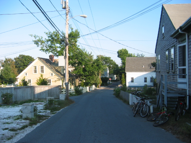

A residential street in Provincetown
Provincetown is the eastern terminus of U.S. Route 6, both in the state and in the nation. Although the terminus is directed east officially, geographically speaking, the road, having curved around Cape Cod, is facing west-southwest at the point, and is marked only by its junction with Route 6A. The state-controlled portion ends with a "State Highway Ends" sign as the road enters the Cape Cod National Seashore, after which the road is under federal maintenance. Route 6A passes through the town as well, mostly following Bradford Street (whereas US 6 originally followed Commercial Street before the bypass was built and Commercial Street was switched to one-way westbound), and ending just south of the Herring Cove Beach.
Provincetown is served by two seasonal ferries to Boston[30][31] and one to Plymouth.[32] They all dock at MacMillan Pier, located just east of the Town Hall in the center of town. When operating at full capacity, the pier accommodates in any given day: 11 ferry trips carrying over 5,000 passengers; five whale watch vessels each running up to three trips a day with a total capacity of 3,600 passengers; the town's commercial fishing fleet of 55 vessels; and many other excursion and visiting vessels.[33] It also plays host several times per year as a destination port-of-call to passengers of organized cruise ship tours, whether themed towards the gay traveller, or towards eco-tourism, arts and other aspects of Provincetown and the outer cape.[33]
The town has no rail service; the town's only railway operated from 1873 until the early 1960s, when it was abandoned by the New York, New Haven and Hartford Railroad. A large portion of the "road" later converted into three roads (Harry Kemp Way, Railroad Avenue and Rear Howland) plus the "Old Colony Nature Pathway", a 1.3-mile (2.1 km) pedestrian path and greenway.
The Cape Cod Regional Transit Authority offers flex route buses between MacMillan Pier and Harwich and a shuttle to Truro. Provincetown is at one end of the scenic "Bike Route 1" from Boston called the Claire Saltonstall Bikeway.
The Provincetown Municipal Airport is located just east of Race Point. This 378 acres (1.530 km2) airport is surrounded by the Cape Cod National Seashore, and is used mostly for General Aviation, but does receive regular scheduled service to Boston or White Plains, New York (with optional car service to Manhattan) via Cape Air, which also operates code-share flights for JetBlue.[34] The airport is a well-equipped, if small, general-aviation airport with a single 3,500-foot (1,100 m) runway, an ILS approach, and full lighting. The nearest national and international service is from Logan International Airport in Boston.
| Historical populations | |||
|---|---|---|---|
| Census | Pop. | %± | |
| 1850 | 3,157 | ||
| 1860 | 3,206 | 1.6% | |
| 1870 | 3,865 | 20.6% | |
| 1880 | 4,346 | 12.4% | |
| 1890 | 4,642 | 6.8% | |
| 1900 | 4,247 | −8.5% | |
| 1910 | 4,369 | 2.9% | |
| 1920 | 4,246 | −2.8% | |
| 1930 | 3,808 | −10.3% | |
| 1940 | 3,668 | −3.7% | |
| 1950 | 3,795 | 3.5% | |
| 1960 | 3,389 | −10.7% | |
| 1970 | 2,911 | −14.1% | |
| 1980 | 3,536 | 21.5% | |
| 1990 | 3,561 | 0.7% | |
| 2000 | 3,431 | −3.7% | |
| 2010 | 2,942 | −14.3% | |
Demographics[]
United States census information[]
According to the U.S. census of 2010,[35] there were 2,942 people residing in the town (down 14.3% since 2000).[36] The population density was 304.2 inhabitants per square mile (117.5 /km2). There were 4,494 housing units (up 15.5%) at an average density of 464.7 per square mile (179.4 /km2). The racial makeup of the town was 91.5% White, 4.0% African American, 0.6% Native American, 0.6% Asian, 1.6% from other races, and 1.7% from two or more races. Hispanic or Latino of any race were 4.8% of the population.
The top reported ancestries were Irish (26.7%, up 9.3% from 2000), English (17.4%, up 2.6%), Portuguese (14.6%, down 8.2%), Italian (13.5%, up 3.4%), and German (12.5%, up 3.6%).[37][38]
Template:Population pyramid There were 1,765 households (down 3.9%), out of which 416 (23.6%) had families, 115 (6.5%) had children under the age of 18 living within them, and 76.4% were non-families. The average household size was 1.64 persons/household, and the average family size was 2.55.
The distribution of the population, broken down by age and gender, is shown in the population pyramid. In 2010, 6.8% of the population was under the age of 18, and the median age was 52.3. There were 1,602 males and 1,340 females.
For 2011, the estimated median income for a year-round household in the town was $46,547, with a mean household income of $74,840. For families, the median income was $87,228, and the mean is $84,050. For nonfamily households, the median income was $42,375, and the mean, $71,008. Median earnings for male full-time, year-round workers was $49,688, versus $36,471 for females. The per capita income for the town was $41,488.[39] About 2.1% of families and 15.4% of the population were below the poverty line, including 26.0% of those under age 18 and 7.5% of those age 65 or over.[40]
Provincetown's ZIP code has the highest concentration of same-sex couple households of any ZIP code in the United States.[41]
Demographics in a resort town[]
Data from traditional demographic sources like the U.S. Census, municipal voting rolls and property records may not accurately portray the demography of resort towns. They often reveal unusual results, as in this case, where the number of housing units far exceeds the Town's total population, where that number of housing units rose 15% while the population dropped 14%, and where nearly 61% of the housing stock is vacant, with 53% designated "for seasonal, recreational, or occasional use", according to the census.[35]
In the decade spanning the years 2000 through 2010, Provincetown's small year-round population declined 14.3% from 3,431 to 2,942, yet during the summer months, population estimates vary wildly, ranging from 19,000 to 60,000. Census figures are unable to capture these dynamic population fluctuations that are associated with seasonal tourism. Part-time residents, which includes non-resident property owners and seasonal residents, are not counted in the census.
Government[]

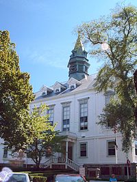
Provincetown Town Hall


Town Hall, seen through the base of the Pilgrim Monument
Provincetown is governed, like most New England towns, by the Open town meeting form of government. In the Town Meeting form of government, the citizens, gathered in the town meeting, act as the legislative branch and approve the budget and amend the town's bylaws, while the popularly elected Board of Selectmen act as the executive branch and hire and oversee the Town Manager, meet regularly to determine policy and appoint members of other boards and commissions.
Provincetown is represented in the Massachusetts House of Representatives as a part of the Fourth Barnstable District, which includes (with the exception of Brewster) all the towns east and north of Harwich on the Cape. The seat is held by Democrat Sarah Peake, a former Provincetown selectman. The town is represented in the Massachusetts Senate as a part of the Cape and Islands District, which includes all of Cape Cod, Martha's Vineyard and Nantucket except the towns of Bourne, Falmouth, Sandwich and a portion of Barnstable.[42] The Senate seat is held by Democrat Julian Cyr. Provincetown is patrolled by its own Police Department[43] as well as the Second (Yarmouth) Barracks of Troop D of the Massachusetts State Police.[44]
On the national level, Provincetown is a part of Massachusetts's 9th congressional district, and is currently represented by Bill Keating. Following the death of Ted Kennedy, the state's senior (Class I) member of the United States Senate was John Kerry (last re-elected in 2008) until he became Secretary of State; that seat has been occupied by Ed Markey since July 16, 2013. The other (Class II) senate seat is held by Elizabeth Warren, a Democrat, elected in the November 2012 elections and sworn in as senator in January 2013. Provincetown is governed by the open town meeting form of government, and is led by a town manager and a board of selectmen. The town has its own police and fire departments, both of which are stationed on Shankpainter Road. The town's post office is located along Commercial Street, near the town's Fourth Wharf. The Provincetown Public Library[45] is a member of the Cape Libraries Automated Materials Sharing library network and is also located along Commercial Street, in the former Center Methodist Episcopal Church building since 2005.
Education[]
Provincetown Schools is an International Baccalaureate World School. Verified in 2013 in the prestigious Primary Years Program and in 2014 in the Middle Years program. Provincetown Schools formally joins the IB community as an IB World School - PYP and MYP continuum program. This is a unique teaching and learning environment where students are encouraged to be global citizens, creative thinkers and open-minded learners. Provincetown Schools is now the only school in Massachusetts to offer the IB continuum, grades PK-8.
Provincetown Schools educates approximately 120 children in Grades PreK - Grade 8. The Veterans Memorial Community Center houses Provincetown Schools Early Learning Center (Wee Care and Preschool ages 3–5).
In 2010, the Provincetown school board elected to phase out the high school program Provincetown High School at the end of the 2012−2013 school year, and send students to nearby Nauset Regional High School in North Eastham, beginning with the 2013−2014 academic year. Provincetown High School's last senior class graduated on June 7, 2013. The final Senior class, consisted of eight students.[46] There are no private schools in Provincetown; high school students from the town will now attend Cape Cod Regional Technical High School in Harwich or Nauset Regional High School in North Eastham. Prior to its closing, Provincetown High School (PHS) served students from seventh through twelfth grades (and for a time also accepted students from Truro). In 2012, Provincetown High School was recognized as one of the smallest high schools in the country with a student population of 32 students in grades 10-12. PHS's sports teams were known as the Fishermen, and the school colors were black and orange.
Culture[]
From 1955 to 1959, the Sun Gallery was run by Yvonne Andersen and Dominic Falcone. It was an art exhibition that took place during the summer where young and up and coming artists could show their work.[47]
The Fine Arts Work Center is a nonprofit educational enterprise, located in Provincetown since 1968. Its stated mission is to encourage the growth and development of emerging visual artists and writers through residency programs, to propagate aesthetic values and experience, and to restore the year-round vitality of the historic art colony of Provincetown.
Provincetown Art Association and Museum (PAAM) is a nationally recognized, year-round cultural institution that celebrated its Centennial in 2014. PAAM mounts 35 art exhibitions each year, offers workshops in the fine arts for children, youth, and adults, and hosts an array of programs and events to enrich visitor experience. The PAAM Permanent Collection consists of 3,000 objects, which are displayed throughout the year in the PAAM galleries.
Between 2004 and 2007, PAAM received four Rural Development grants and loans totaling $3 million to increase the museum's space, add climate-controlled facilities, renovate a historic sea captain's house (the Hargood House) and cover cost overruns.[48] As the mission of the Rural Development program is "To increase economic opportunity and improve the quality of life for all rural Americans",[49] the USDA considered Provincetown's residents in the 2000s to still be rural and to still require such federal assistance.
In 2003, Provincetown received a $1.95 million low interest loan from the Rural Development program of the U.S. Department of Agriculture to help rebuild the town's MacMillan Pier. It primarily serves the town's active fishing fleet, and also tourists and high-speed ferries.
The Atlantic House in Provincetown is considered the oldest gay bar in the US and Frommer's calls it "the nation's premier gay bar".[50][51][52][53]
The Art House provides a venue for numerous entertainers and shows during the summer season, in particular Varla Jean Merman, Miss Richfield 1981, Ms. CoCo Peru, and other town favorites. In off season, the Art House remains open providing nightly entertainment that includes a Wii Bowling League, Trivia Night, and similar events.
Provincetown is the setting for the annual "Women's Week" festival. Held in mid-October since 1984 and attended by almost 2,000 women, it is the "longest running lesbian cultural event in the Northeast".[54][55][56]
Since 1975, Provincetown has been the host city to Fantasia Fair, the world's first and longest-running annual conference that focuses on gender diversity and transgender issues.[57]
The Provincetown International Film Festival, honors the best in independent and avante garde film. Among the honorees for 2014 were actress Patricia Clarkson and director David Cronenberg. Previous honorees include Matt Dillon, Harmony Korine, Parker Posey, Roger Corman, Vera Farmiga, Darren Aronofsky, Quentin Tarantino, Jane Lynch, Gael García Bernal, Tilda Swinton, Kathleen Turner, Jim Jarmusch, Todd Haynes, Gus Van Sant, and John Waters. Waters, a summer resident, is a major participant in the festival.
In November, 2011, the Provincetown Theater Company became the first theater company in New England to stage a live-action dramatic theatrical presentation of horror-fantasy author H.P. Lovecraft. The story was Lovecraft's 1919 classic, "The Picture in the House," and was described as "...the macabre come to life." The adaptation was produced for the 22nd Fall Playwright's Festival.[58]
Provincetown in popular culture[]
- Lesbian Romance author Radclyffe set popular romance series Provincetown Tales here. Third edition released in 2004
- in Cynthia Voigt's 1981 first novel of the "Homecoming" series, Homecoming, the main characters, Dicey, James, Elizibeth, and Sammy are from Provincetown. Some of the characters return or in prequel live in Provincetown.
- Denis Johnson's 1991 novel Resuscitation of a Hanged Man is set in Provincetown.
- Norman Mailer's novel Tough Guys Don't Dance and Annie Dillard's novel The Maytrees are primarily based in Provincetown.
- Jon Loomis's Frank Coffin mystery series is set in Provincetown.
- In the 1990s, Subaru stealthily targeted ads at lesbians. In one ad, the license plate read "P-TOWN".
- The town is mentioned, along with various other Cape Cod locations, in the Vampire Weekend song "Walcott," included on their 2008 debut album Vampire Weekend.
- Most of the events in the 2012 film BearCity 2: The Proposal take place in Provincetown during Bear Week.
- On the Cartoon Network's Adult Swim show The Venture Bros., Colonel Gentleman describes a sexual neologism referencing Provincetown. He is "the one that started that craze back in P-Town with Tennessee Williams."
- In Glee popular couple Kurt and Blaine honeymoon in Provincetown following their joint wedding with Brittany and Santana.
- In Season 6, Episode 17 of the TV series 30 Rock, Jack Donaghy's mother Colleen references Provincetown in her explanation as to why she never says "I love you" to her son. "Jacky and I know how we feel. We don't have to say it out loud like a couple of gays getting married in jean shorts in Provincetown, while I'm just trying to enjoy an ice cream on the pier."[59]
- In the TV series 30 Rock, Jack Donaghy's nemesis Devon Banks references Provincetown in a threat to Donaghy. "If this Liz Lemon project loses one penny, I am going to publicly flog you like… well, like me at the Provincetown Flogging Festival.”[60]
- The lyrics of Boston grindcore band Anal Cunt's song, "02657", from their 1996 album 40 More Reasons to Hate Us, lampoon Provincetown's large LGBT community. Its title is a reference to Provincetown's ZIP code.
Notable people[]
- Playwrights Tennessee Williams, Eugene O'Neill, and Susan Glaspell
- Former United States Poet Laureate Stanley Kunitz
- International journalists Mary Heaton Vorse, John Reed, and Louise Bryant
- Visual artists Jackson Pollock, Charles Hawthorne, Edwin Dickinson, Marsden Hartley, Robert Motherwell, Hans Hofmann, Franz Kline, Willem de Kooning, Henry Hensche, George Morrison, Herman Maril, Max Bohm, Nela Arias-Misson, Pat de Groot and Anne Packard.
- Photographer Joel Meyerowitz
- Arctic explorer Donald B. MacMillan
- Norman Mailer, author, winner of the Pulitzer Prize, and co-founder of The Village Voice
- Mary Oliver, poet and winner of the Pulitzer Prize
- John Waters, filmmaker
- Harry Kemp poet of the dunes and author ""Tramping on Life" and "More Miles"
- Michael Cunningham, author of the Pulitzer Prize-winning The Hours
- David Drake, Obie Award-winning playwright, stage director, actor and author
- Andrew Sullivan, author and blogger
- Andy Towle, poet and founder of Towleroad.com
- Al Jaffee, cartoonist for MAD Magazine
- Mark Doty, poet and author
- Cookie Mueller, writer, performer, and Dreamlander
- William J. Mann, author and historian
- Kate Clinton, comedian and writer
- Prescott Townsend, early LGBT activist
- Sarah Peake, state representative, 4th Barnstable District
- Mark Protosevich, screenwriter of The Cell and the 2007 adaptation of I Am Legend
- "Lady of the Dunes," an unidentified murder victim discovered in 1974 [61]
- Blanche Lazzell, modernist painter and printmaker
- Alan Emtage, Internet pioneer and photographer
- Howard Mitcham, artist, poet, cook
- Frank X. Gaspar, poet and author
- Alice Brock, subject of Arlo Guthrie's 1966 song "Alice's Restaurant", owns an art gallery in town
- Ryan Landry, actor, playwright
- Kurt Vonnegut, writer
- John Krakauer, journalist, author
- Anthony Bourdain, chef, author, television host
- Channing Wilroy, actor and Dreamlander
- Judy Gold, stand-up comic
- Mo Rocca, satirist (NPR/Daily Show)
- Stella Starsky & Quinn Cox, authors (Sextrology, Cosmic Coupling), astrologers, TV personalities, columnists (Daily Beast)
- Ryan Murphy, Television director
- Barry Clifford, underwater archaeological explorer best known for discovering the remains of the wrecked ship Whydah
- Martha Dewing Woodward, artist who created first summer art school in Provincetown[62]
- Tony Kushner, award-winning playwright
- A.G.Dumas, poet and author of "Summer Night Walk in Provincetown," "Zombie Apocalypse at Low Tide" and "The Robbed Is Not Blameless."
Notable Barnstable County Monuments[]


View of the Pilgrim Monument with the Mayflower Compact bas-relief by Cyrus Dallin below, as seen from Bradford Street.
Pilgrim Monument and Provincetown Museum[]
The Pilgrim Monument in Provincetown, Massachusetts, was built between 1907 and 1910 to commemorate the first landfall of the Pilgrims in 1620 and the signing of the Mayflower Compact in Provincetown Harbor before they continued onwards to Plymouth MA. This 252-feet tall campanile is the tallest all-granite structure in the United States and is part of the Provincetown Historic District. It is also connected to Provincetown Museum.
The Provincetown Museum is a charming mix of the old and the new. The permanent exhibits retain the charm of an old-fashioned history museum. Exhibits highlight the arrival of the Mayflower Pilgrims, the town’s rich maritime history, the early days of modern American theater in Provincetown, and the building of the monument.
There is also a recreation of a 19th century sea captain’s parlor at home and his quarters at sea, a diorama of the Mayflower Compact being signed aboard the Mayflower in Provincetown Harbor, and a scale model of the first theater of the Provincetown Players.
References[]
- ^ a b c "American FactFinder". United States Census Bureau. http://factfinder2.census.gov. Retrieved 2011-05-14.
- ^ "2009-2013 American Community Survey". U.S. Census Bureau. http://factfinder.census.gov/bkmk/table/1.0/en/ACS/13_5YR/B01003/0600000US2500155500. Retrieved 23 June 2014.
- ^ Town of Provincetown: http://www.provincetown-ma.gov/
- ^ Bragg, Mary Ann. "Raw sewage soils P'town police headquarters". Archived from the original on 2009-08-21. https://web.archive.org/web/20090821034918/http://www.capecodonline.com/apps/pbcs.dll/article?AID=%2F20090414%2FNEWS%2F904140305%2F-1%2FNEWSMAP. Retrieved 2009-04-30.
- ^ Archer, Gabriel (16 February 2010) [1912]. "Bartholomew Gosnold's Discovery of Cape Cod (1602)". In Halsey, Francis W. (Francis Whiting). Great Epochs in American History. Vol. II, The Planting Of The First Colonies: 1562—1733. New York & London: Funk & Wagnalls. http://www.usgennet.org/usa/topic/preservation/epochs/vol2/pg38.htm. Retrieved 12 July 2015.
- ^ Rich, Shebnah (1883). Truro-Cape Cod or Land Marks and Sea Marks. Boston: D. Lothrop & Co.. p. 53. https://books.google.com/books?id=Rcdk_lguAMcC&pg=RA1-PA151&lpg=RA1-PA61.
- ^ Hopkins, James H. (1890). Deyo, Simeon L.. ed. History of Barnstable County. New York: H. W. Blake & Co.. p. 950. http://capecodhistory.us/Deyo/Provincetown-Deyo.htm.
- ^ a b c "Historical Timeline of Provincetown, Massachusetts" (PDF). Town of Provincetown. http://www.provincetown-ma.gov/DocumentCenter/Home/View/874. Retrieved 1 May 2012.
- ^ a b Hopkins 1890, p. 961.
- ^ Hopkins 1890, p. 963.
- ^ Hopkins 1890, p. 965.
- ^ Greene, Sachse & McCauley 2006, p. 163.
- ^ Karen Christel Krahulik, Provincetown: From Pilgrim Landing to Gay Resort, NYU Press, 2007, p. 51.
- ^ (Motion Picture) Provincetown artist colony (excerpt feat. Charles Webster Hawthorne). Provincetown, Massachusetts: Metro Pictures Corporation. 1916. Excerpt length 41s. Oregon Historical Society/Gene Stoeller Collection, 1577. Archived from the original on 2013-12-13. https://web.archive.org/web/20131213022132/http://oldfilm.org/collection/index.php/Detail/Collection/Show/collection_id/337. Retrieved 16 September 2013. "This collection consists of a short edited and intertitled 35 mm. film produced in 1916 by Metro Pictures. Primary source: film (500 ft.) : si., b&w ; 35mm nitrate print."
- ^ "Same-Sex Couples Since 1990", New York Times, August 24, 2011
- ^ David Colman (September 4, 2005). "Rich Gay, Poor Gay". New York Times. Retrieved on May 22, 2010.
- ^ a b Horsley Witten Group (April 19, 2007). "Town of Provincetown Open Space and Recreation Plan". Town of Provincetown Open Space Committee & Recreation Commission. p. 18. http://www.provincetown-ma.gov/DocumentCenter/Home/View/68. Retrieved 20 December 2012.
- ^ Green, Eugene; Sachse, William; McCaulley, Brian (2006). The Names of Cape Cod. Arcadia Press. p. 138. ISBN 978-1-933212-84-5.
- ^ Greene, Sachse & McCauley 2006, p. 139.
- ^ "USDA Plant Hardiness Zone Map - Massachusetts". USDA. http://planthardiness.ars.usda.gov/PHZMWeb/Images/72DPI/ma.jpg. Retrieved 24 December 2012.
- ^ "General Climate Summary Tables". Western Regional Climate Center. http://www.wrcc.dri.edu/cgi-bin/cliMAIN.pl?ma6681. Retrieved February 19, 2013.
- ^ "Climate Statistics for Provincetown, Massachusetts". http://www.weather.com/weather/wxclimatology/monthly/graph/USMA0338. Retrieved May 7, 2012.
- ^ a b Bureau of U.S. Topographical Engineers (1836). A map of the extremity Of Cape Cod including the Townships of Provincetown & Truro: with a chart of their sea coast and of Cape Cod Harbour, State of Massachusetts (Map). 1 : 10,560. Cartography by U.S. Topographical Engineers, under direction of Maj. J.D. Graham; Reduced from orig. by Washington Hood. http://www.davidrumsey.com/luna/servlet/detail/RUMSEY~8~1~226232~5505141%3b-Composite-of--A-Map-Of-The-Extremi#. Retrieved 2 June 2012.
- ^ Jennings (1890), p. 197.
- ^ a b Theriault, Wor. James J.. "The Railroad Comes To Provincetown". King Hirams's Lodge of Ancient Free and Accepted Masons. http://www.kinghiramslodge.org/railroad.html. Retrieved 2 May 2012.
- ^ a b United States Geological Survey (July 1889) [Surveyed 1887] (PDF). Massachusetts: Provincetown Sheet (Map). 1 : 62,500. Cartography by Henry Gannett (Chief Geographer) and Marcus Baker (Geographer-in-Charge). http://ims.er.usgs.gov/gda_services/download?item_id=5635853&quad=Provincetown&state=MA&grid=15X15&series=Map%20GeoPDF. Retrieved 23 May 2012.
- ^ Jennings, Herman A. (1890). Provincetown or Odds and Ends From the Tip End. Peaked Hill Press. p. 197. https://books.google.com/books?id=VXdHAAAAYAAJ&pg=PA197#v=onepage&q&f=false.
- ^ Rich (1883), p. 457.
- ^ Paine-Smith, Nancy W. (1922). The Provincetown Book. Brockton, MA: Tolman Print, Inc.. p. 43. https://books.google.com/books?id=9NEMAAAAYAAJ&pg=PA43.
- ^ "Provincetown Ferry - Fast & Luxurious". Boston Harbor Cruises. http://www.bostonharborcruises.com/provincetown-ferry/. Retrieved 1 May 2012.
- ^ Boston-Provincetown ferry Retrieved on Aug 2, 2010
- ^ Plymouth-Provincetown ferry Archived 2007-04-12 at the Wayback Machine Retrieved on April 5, 2007
- ^ a b McKinsey, Rex. "Public statement by the Harbormaster". Facebook.com. https://www.facebook.com/groups/PtownTownTalk/permalink/642616245905719/. Retrieved 17 September 2016.
- ^ "Where we fly - New England". Cape Air. Archived from the original on 5 May 2012. https://web.archive.org/web/20120505121208/https://www.capeair.com/where_we_fly/new_england.html. Retrieved 1 May 2012.
- ^ a b "Profile of General Population and Housing Characteristics: 2010". 2010 U.S. Census. United States Census Bureau. http://factfinder2.census.gov/bkmk/table/1.0/en/DEC/10_DP/DPDP1/0600000US2500155500. Retrieved December 21, 2012.
- ^ "Profile of General Demographic Characteristics: 2000". 2000 U.S. Census. United States Census Bureau. http://factfinder2.census.gov/bkmk/table/1.0/en/DEC/00_SF1/DP1/0600000US2500155500. Retrieved September 16, 2014.
- ^ "People Reporting Ancestry, 2006-2010 American Community Survey 5-Year Estimates". American Factfinder. U.S. Census Bureau. http://factfinder2.census.gov/bkmk/table/1.0/en/ACS/10_5YR/B04006/0600000US2500155500. Retrieved 22 December 2012.
- ^ "Profile of Selected Social Characteristics: 2000". Census 2000 Summary File 3 (SF 3). U.S. Census Bureau. http://factfinder2.census.gov/bkmk/table/1.0/en/DEC/00_SF3/DP2/0600000US2500155500. Retrieved 22 December 2012.
- ^ "SELECTED ECONOMIC CHARACTERISTICS". 2007-2011 American Community Survey 5-Year Estimates. U.S. Census Bureau. http://factfinder2.census.gov/bkmk/table/1.0/en/ACS/11_5YR/DP03/0600000US2500155500. Retrieved 22 December 2012.
- ^ "POVERTY STATUS IN THE PAST 12 MONTHS". 2007-2011 American Community Survey 5-Year Estimates. U.S. Census Bureau. http://factfinder2.census.gov/bkmk/table/1.0/en/ACS/11_5YR/S1701/0600000US2500155500. Retrieved 22 December 2012.
- ^ Facts and Findings from The Gay and Lesbian Atlas, Urban Institute, March 30, 2004
- ^ Index of Legislative Representation by City and Town, from Mass.gov
- ^ "Town of Provincetown - Official Website - Police". Town of Provincetown. http://www.provincetown-ma.gov/index.aspx?NID=82. Retrieved 1 May 2012.
- ^ Station D-2, SP Yarmouth
- ^ Provincetown Public Library, provincetownlibrary.org.
- ^ https://www.bostonglobe.com/metro/2013/06/08/provincetown-high-sends-off-its-final-graduating-class/KDoD6enm39DpRSLsYPpCjJ/story.html
- ^ Giuliano, Yvonne Anderson and Charles. "Yvonne Andersen on The Sun Gallery - Berkshire Fine Arts". http://www.berkshirefinearts.com/05-10-2013_yvonne-andersen-on-the-sun-gallery.htm.
- ^ (April 6, 2007) "Rural Aid Goes to Urban Areas: USDA Development Program Helps Suburbs, Resort Cities". Washington Post. Retrieved on May 22, 2010.
- ^ USDA Rural Development: mission statement Archived 2007-02-08 at the Wayback Machine Retrieved on April 5, 2007
- ^ The History of Atlantic House
- ^ Café Lafitte in Exile in New Orleans, Louisiana purports to be the oldest gay bar in the country but an investigation of that establishment's website and a few other sources failed to reveal the dates or specifics upon which that claim is based.
- ^ Frommer's review of The Atlantic House.
- ^ Mallory Curley, A Cookie Mueller Encyclopedia (Randy Press, 2010), p. 23.
- ^ Desroches, Steve (October 8, 2014). "Women’s Week Celebrates a 30-year Herstory". Provincetown Magazine. http://provincetownmagazine.com/2014/10/08/womens-week-celebrates-a-30-year-herstory/. Retrieved February 28, 2017.
- ^ "Provincetown Blows the Candles Out on 30 Years of Celebrating Women in 2014". October 7, 2014. http://provincetowntourismoffice.org/2014/10/provincetown-blows-the-candles-out-on-30-years-of-celebrating-women-in-2014/. Retrieved February 28, 2017.
- ^ "Women's Week Provincetown". http://www.womensweekprovincetown.com/.
- ^ History of Fantasia Fair Retrieved on July 16, 2017
- ^ Shabott, Laura (7 November 2011). "The 22nd Playwright Festival". Provincetown.com. http://www.provincetown.com/fine_provincetown_art_craft/gallery_dealer_photo/_/18953/. Retrieved 1 May 2012.
- ^ https://www.theatlantic.com/entertainment/archive/2013/01/aint-no-party-like-a-liz-lemon-party-100-of-the-best-30-rock-quotes/272733/
- ^ "Archived copy". Archived from the original on 2015-05-18. https://web.archive.org/web/20150518092403/http://blog.comedycentral.co.uk/2012/03/27/the-best-devin-banks-quotes-30-rock/. Retrieved 2015-05-15.
- ^ ""Lady in the Dunes" may be another of Whitey Bulger's victims". Cape Cod Today. 3 March 2012. Archived from the original on 1 March 2014. https://web.archive.org/web/20140301005816/http://www.capecodtoday.com/article/2012/03/03/10101-lady-dunes-may-be-another-whitey-bulgers-victims. Retrieved 12 March 2014.
- ^ Dunlap, David W. (2015). Building Provincetown. Provincetown, Mass.: Town of Provincetown and Provincetown Historical Commission. p. 72.
Further reading[]
- Whiting, John. "Womb with a View, Growing up in Provincetown". http://thankyouoneandall.co.uk/letters/ptown.htm.
External links[]
| Find more about Provincetown, Massachusetts on Wikipedia's sister projects: |
| Source texts from Wikisource | |
| Images and media from Commons |
- Town of Provincetown official website
- Provincetown official tourism website
- Provincetown Chamber of Commerce
| ||||||||||||||||||||

.jpg)
| |||||
| This page uses content from the English language Wikipedia. The original content was at Provincetown, Massachusetts. The list of authors can be seen in the page history. As with this Familypedia wiki, the content of Wikipedia is available under the Creative Commons License. |