| Main | Births etc |
|---|
| Riverhead, New York | |
|---|---|
| — Town — | |
| Town of Riverhead | |
 |
|

Riverhead, New York |
|
| Coordinates: Coordinates: | |
| Country | United States |
| State | New York |
| County | Suffolk |
| Government | |
| • Type | Civil Township |
| • Supervisor | Sean Walter |
| Area | |
| • Total | 201.3 sq mi (521.3 km2) |
| • Land | 67.4 sq mi (174.5 km2) |
| • Water | 133.9 sq mi (346.8 km2) |
| Elevation | 13 ft (4 m) |
| Population (2010) | |
| • Total | 33,506 |
| • Density | 170/sq mi (64/km2) |
| Time zone | Eastern (EST) (UTC-5) |
| • Summer (DST) | EDT (UTC-4) |
| ZIP code | 11901 |
| Area code(s) | 631 |
| FIPS code | |
| GNIS feature ID | 0962565 |
| Website | townofriverheadny.com |
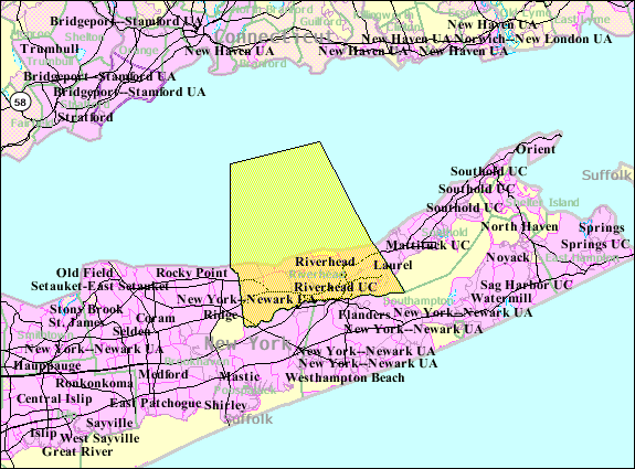
The town of Riverhead is in Suffolk County, New York, on the north shore of Long Island. The population was 33,506 at the 2010 census. The name signifies that the mouth of the Peconic River is in this town. Riverhead is the county seat of Suffolk County.
There is also a smaller hamlet of Riverhead, which lies in the town.
History[]
The town was created in 1792 as part of developing new jurisdictions after the American Revolution. The New York State Legislature divided it from the extant Southold, New York. Colonists had purchased the Southold land from the local Algonquian-speaking Native Americans in 1649. An additional portion was purchased from Col. William Smith and divided among settlers in 1742. The poor section of Southold, with no harbor and little commerce, the town was separated at the behest of its inhabitants, who "represented to the Legislature that their town is so long that it is very inconvenient for them to attend at [sic] town meetings, and also to transact the other necessary business of the said town, and have prayed that the same may be divided into two towns".
On March 13, 1792, the Legislature passed a bill splitting off this section under the name River Head. The new enclave's first town meeting was scheduled to be held April 3, 1792.[1] River Head was named the county seat (called "county town" at the time), and its name was later combined as Riverhead. By 1902, its approximate population was 2,500.[1]
Geography[]
The north town line is delineated by Long Island Sound with Connecticut on the opposite shore. The east town line is the border of the town of Southold. The town is partly on the North Fork of the county. The eastern terminus of the Long Island Expressway is in Riverhead.
According to the United States Census Bureau, the town has a total area of 201.3 square miles (521 km2), of which 67.4 square miles (175 km2) is land and 133.9 square miles (347 km2), or 66.53%, is water.
Demographics[]
As of the census[2] of 2010, there were 33,506 people and 15,424 households residing in the town. The population density was 497.1 people per square mile (192.0/km²).
As of the census[2] of 2000, There were 10,749 households out of which 28.1% had children under the age of 18 living with them, 54.0% were married couples living together, 10.3% had a female householder with no husband present, and 32.2% were non-families. 26.4% of all households were made up of individuals and 14.1% had someone living alone who was 65 years of age or older. The average household size was 2.50 and the average family size was 3.01.
As of the census[2] of 2010, in the town the population was spread out with 20.4% under the age of 18, 2.2% from 18 to 20, 6.1% from 20 to 24, 10.5% from 25 to 34, 20.6% from 35 to 49, 21.8% from 49 to 64, and 19.4% who were 65 years of age or older. For every 100 females there were 99.0 males.
As of the census[2] of 2000, the median income for a household in the town was $52,195, and the median income for a family was $60,939. Males had a median income of $40,855 versus $32,288 for females. The per capita income for the town was $24,647. About 15.8% of families and 17.9% of the population were below the poverty line, including 20.7% of those under age 18 and 7.4% of those age 65 or over.
Government and politics[]


Flag of the Town of Riverhead flying at Grumman Memorial Park.
Riverhead has a town council government. There is an elected Town Supervisor who is elected by the entire town, and four "at large" Town Council seats. The current town supervisor is Sean Walter, a Republican who was re-elected in November 2013 with 55.85% of the vote.
Media[]
The Riverhead newspaper The News-Review, owned by Times-Review Newspapers as of at least 2010, was founded in 1868. Its parent company also owns The Suffolk Times, Shelter Island Reporter, The North Shore Sun, and The Wine Press.[3]
Radio stations WFTU, WRCN-FM and WRIV are licensed to Riverhead.
Communities and locations[]
Hamlets (unincorporated)[]
- Aquebogue
- Baiting Hollow
- Calverton (partially; shared with Town of Brookhaven)
- Jamesport
- Laurel (partially; shared with Town of Southold)
- Manorville (Partially; Shared with Town of Brookhaven)
- Northville
- Riverhead
- Wading River (partially; shared with Town of Brookhaven)
Other communities[]
- Centerville
- Polishtown
- Reeves Park
- Roanoke
- South Jamesport
- Sweyze
State parks[]
- Wildwood State Park
See also[]
- National Register of Historic Places listings in Riverhead (town), New York
Footnotes[]
- ^ a b Ross, Peter. River Head: A History of Long Island: From its Earliest Settlement to the Present Time (Lewis Publishing: New York, 1902)
- ^ a b c d "American FactFinder". United States Census Bureau. http://factfinder.census.gov. Retrieved 2008-01-31.
- ^ The News-Review
References[]
- Town of Riverhead official site
- 2000 census data
External links[]
- Riverhead Central School District
- Taussig, Charles William, The Book of Radio (1922), Chapter XXI "The World's Greatest Radio Station", pp. 312–327
| |||||||||||||||||||||||

Template:RiverheadNY
| This page uses content from the English language Wikipedia. The original content was at Riverhead (town), New York. The list of authors can be seen in the page history. As with this Familypedia wiki, the content of Wikipedia is available under the Creative Commons License. |