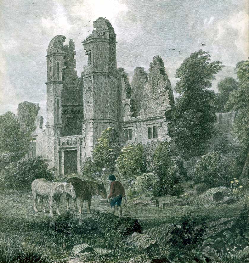
Ruins of Rocksavage c. 1818; the octagonal towers flanked the gateway
Rocksavage or Rock Savage was an Elizabethan mansion, now in ruins, at SJ526799 in Clifton (now a district of Runcorn), Cheshire, England. Built for Sir John Savage, MP in 1565–8, Rocksavage was one of the great Elizabethan houses of the county; in 1674, it was the second largest house in Cheshire. James I visited in 1617. The house was abandoned when it passed into the Cholmondeley family early in the 18th century, and by 1782 only ruins remained.
Rocksavage was a sandstone quadrangle around a central courtyard, with paired octagonal towers flanking the main entrance. Only fragments of its garden and orchard walls are still standing; they are listed at grade II.
History[]
The Savage family were important Cheshire landowners from the late 1370s, when the family acquired lands at Clifton by the marriage of John Savage (d. 1386) to Margaret Danyers.[1] Sir John Savage (d. 1597/8) was the seneschal of Halton Castle, and also served at various times as a member of parliament for Cheshire, mayor of Chester and High Sheriff of Cheshire.[1][2] Rocksavage was built for him on a hillside overlooking the River Weaver. Started in around 1565, the house was completed in 1568.[3][4][5][6] Rocksavage was one of the great Elizabethan "prodigy houses" of Cheshire.[7][8] Hearth-tax assessments of 1674 show that it was the second largest house in the county, its fifty hearths being surpassed only by Cholmondeley House.[9] An early 17th century description praised the mansion's "magnificent fabric".[10] The medieval family seat of Clifton Hall stood nearby, and was retained as farm and service buildings.[2][9]
James I dined at Rocksavage with his retinue on 21 August 1617 on his way to Vale Royal Abbey and Chester.[10] During the Civil War, John Savage, Earl Rivers, declared for the royalist side. Rocksavage was ransacked by parliamentarian forces, and the roof and part of the walls were destroyed.[8] The first Duke of Monmouth stayed at Rocksavage on 13 September 1682 as a guest of Thomas Savage, Earl Rivers, while touring Cheshire to assess support for a faction opposed to Charles II.[2][11]
The estate passed by marriage to James Barry, Earl of Barrymore, in the early 18th century.[12] Further buildings were constructed higher up the hill by the Earl of Barrymore, possibly by the architect Henry Sephton.[4] Now known as Clifton Hall, these might have been intended as a replacement for Rocksavage or as service buildings for the main mansion.[3][4] A few years after these buildings were erected, Rocksavage was abandoned when the Barrymore heiress married into the Cholmondeley family and the principal seat of the joint estate became Cholmondeley House.[4][12][13] (The marquesses of Cholmondeley retain "Earl of Rocksavage" as a courtesy title for the heir.[14]) The empty house soon decayed and was already in ruins by 1782.[3][13]
Description[]

Ruins of Rocksavage in 2007
The design of the Elizabethan mansion was a quadrangle of four bays in the local red sandstone, built around a central courtyard, and was symmetrical but not classical.[4][8][15][16] The main entrance was a gateway flanked by octagonal towers with domed tops and bridged by a crenellated wall.[4][6][8][15] The towers are prominent in an engraving of the ruins, after Peter de Wint, which dates from around 1818 and appears in George Ormerod's The History of the County Palatine and City of Chester.[5][15] Brereton Hall, built some twenty years later by Sir John Savage's ward and son-in-law Sir William Brereton, was modelled on Rocksavage and copied its paired octagonal towers.[6][15] Unlike Brereton Hall, the string courses of the Rocksavage towers extended around the adjoining walls.[15]
The last major remnant of the house fell in around 1980.[2] Only the orchard gateposts and fragments of garden and orchard walls now remain near the M56 Weaver Viaduct in Runcorn; they are recorded in the National Heritage List for England as a designated Grade II listed building.[2][3][5]
The 18th-century Clifton Hall was originally a U-shaped brick building with prominent stone pilasters. One arm of the U has been demolished and the remnant is now surrounded by farm buildings.[4]
See also[]
- Listed buildings in Runcorn (rural area)
References[]
- ^ a b Thornton, Tim. "Savage family (per. c.1369–1528)" in: Oxford Dictionary of National Biography (Oxford University Press; 2004, 2007) (accessed 19 February 2009)
- ^ a b c d e Some notes on the history of Clifton (Rocksavage) near Runcorn, in Cheshire. Runcorn and District Historical Society (accessed 19 February 2009)
- ^ a b c d Remains of Rock Savage (1330365). National Heritage List for England. English Heritage. Retrieved 4 April 2015none
- ^ a b c d e f g de Figueiredo, Peter & Treuherz, Julian (1988). Cheshire Country Houses, p. 268 (Chichester: Phillimore) (ISBN 0 85033 655 4)
- ^ a b c Pevsner, Nikolaus & Hubbard, Edward (1971). The Buildings of England: Cheshire, p. 180 (Harmondsworth: Penguin Books) (ISBN 0 14 071042 6)
- ^ a b c Beck, Joan (1969). Tudor Cheshire (A History of Cheshire, Vol. 7; series editor: J.J. Bagley), pp. 29–30 (Chester: Cheshire Community Council)
- ^ de Figueiredo & Treuherz, pp. 5, 6
- ^ a b c d Starkey, Bert. Rocksavage Hall. Runcorn and District Historical Society (accessed 19 February 2009)
- ^ a b Hodson, J. Howard (1978). Cheshire, 1660–1780: Restoration to Industrial Revolution (A History of Cheshire, Vol. 9; series editor: J.J. Bagley), p. 77 (Chester: Cheshire Community Council) (ISBN 0 903119 10 2)
- ^ a b Dore, R.N. (1966). The Civil Wars in Cheshire (A History of Cheshire, Vol. 8; series editor: J.J. Bagley), pp. 1–2 (Chester: Cheshire Community Council)
- ^ Hodson, p. 11
- ^ a b Hodson, p. 79
- ^ a b Robinson, John Martin (1991). A Guide to the Country Houses of the North-West, p. 60 (London: Constable) (ISBN 0 09 469920 8)
- ^ Burke's Peerage and Gentry: Cholmondeley (accessed 19 February 2009)
- ^ a b c d e de Figueiredo & Treuherz, p. 45
- ^ de Figueiredo & Treuherz, p. 6
| This page uses content from the English language Wikipedia. The original content was at Rocksavage. The list of authors can be seen in the page history. As with this Familypedia wiki, the content of Wikipedia is available under the Creative Commons License. |