| ||||||||||||||
| Rohtak district रोहतक जिला |
|
|---|---|
| — District of Haryana — | |
 |
|
| Country | India |
| State | Haryana |
| Established | |
| Headquarters | Rohtak |
| Tehsils | 1. Rohtak, 2. Mehem |
| Government | |
| • Lok Sabha constituencies | Rohtak |
| • Assembly seats | 4 |
| Area | |
| • Total | 1,668 km2 (644 sq mi) |
| Population (2001) | |
| • Total | 940,128 |
| • Density | 560/km2 (1,500/sq mi) |
| • Urban | 35.06% |
| Demographics | |
| • Literacy | 74.56% |
| • Sex ratio | 847 |
| Coordinates | - |
| Website | Official website |
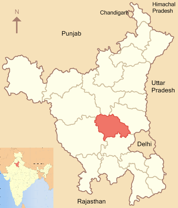
Rohtak district (Hindi: रोहतक ज़िला) is one of the 21 districts of Haryana state in northern India. It is located in the southeast of Haryana and northwest of Delhi, bounded by Jind and Sonipat districts to the north, Jhajjar and Sonipat districts to the east, and Hissar, Sirsa, and Bhiwani districts to the west. Rohtak city is the district headquarters.
Rohtak is home to the current chief minister of Haryana, Bhupinder Singh Hooda. Quilla Road is an upmarket place near the old walled city, where people come from all parts of the city and surrounding towns. The city has a cosmopolitan character, comprising Jat, Punjabi, Vaishya, Yadav, Brahmins, and other communities.
History[]
The antiquity of the region goes back to the pre-Vedic Chalcolithic/Bronze Age. The ancient remains of the villages and towns related to the last phase of Indus Civilisation, going back at least 4,000 years, can still be seen around the region, particularly at Farmana near Mahem and Lahot near Dhansa border. After the fall of the Indus towns, the village settlements of the Late Harappa tradition survived until the middle of the second millennium BC in its decadent phase.
The advent of a new cultural tradition around 1500 BC most probably from the North-West of the subcontinent and beyond displaced the preceding Chalcolihthic/Indus survivors from the Gandhara region of Pakistan to Bihar. It manifested into at least three related regional cultures, the Gandhara Grave culture (c. 1500-500 BC), the Painted Grey Ware (PGW) culture (c.1100- 500 BC) and the Black Slipped Ware (BSW) culture (c.800-600 BC).
The peasant-pastoral PGW culture was distinguished by the use of iron, horse and cattle and a thin grey coloured and painted pottery. It spread from Sutlej to the Ganges and particularly along the Saraswati valley in northern plains. Its discovery from Hastinapur, Panipat, Pehowa, Kurukshetra, Mathura. Indraprastha or Delhi excited the imagination of the traditional archaeologists to associate the culture with the Mahabharat heroes. However, the geographical distribution, chronology and the cultural milieu of the PGW culture can be well compared with the culture of the Vedic (later phase) literature or Aryans. The discovery of the PGW culture from the lowest levels of Khokhrakot at Rohtak attests the intrusion of the Vedic people at Rohtak in the later Vedic period. The semi-agricultural and pastoral Aryans of the Rig Veda had by now taken to settled Janapadas and developed agrarian economy assisted by relevant iron technology and social organisation comprising the Varna System. It is about this period that the Gana Rajyas (tribal republics) or chiefdoms came into existence.
The political struggle for domination ensued and the more successful established city states or the Mahajanapadas in the 7th century BC. It is from now onwards that the history of India growingly becomes the history of the struggle of centripetal and centrifugal forces. The Magadhan empire emerged successful in establishing almost a pan-Indian hegemony under the Nandas and the Mauryas and gave impetus to the rise of regional cities.
The Rohtak tract saw the growth of Second Urbanisation in the early historic times in the 4th century BC as evidenced by the excavations at Khokhra Kot mound near the town. The discovery of Ashokan pillars at Topra in North Haryana and at Hissar and Fatehabad attests the expansion of the Mauryan Empire in our region. The period was marked by the popularity of Prakrit language, the spread of Buddhism, the beginning of brick architecture, coinage and the Brahmi alphabets (a new script). After the collapse of the Mauryan empire the region saw the resurgence of the Tribal republic of the Yaudheyas to be subdued again by the invading Indo- Greeks, Sakas and Kushanas before the beginning of the Christian era. The Kushana rule integrated North India with Central Asia. The period saw the growth of urbanisation to higher peaks by boosting trade with Central and Western Asia and Europe. The assimilation of a variety of foreign elements enriched the Culture of India. The early historical period was also distinguished by the prevalence of slavery, caste system, decline in the status of women and untouchables under the sanction of the state and the Dharma Shastras.
The disintegration of the Kushana empire in the 3rd century AD again led to the rise of the Yaudheyas (tribal republic) at Rohtak as attested by the discovery of their seals and coin mounds. They were, however, subjugated by another Magadhan empire of the Guptas in the 4th century AD. Soon after, the urban centres decayed gradually giving way to the rise of feudal society and culture, agrarian economy, decentralisation of power and a new hierarchical social order. The town of Rohtak also decayed. The invasion by the Hunas, indicated anarchic conditions of the times.
The early centuries of the Christian era was a great era of cultural fusion when the foreign invaders like the Indo-Greeks, Sakas, Kushanas and the Hunas were assimilated. Stupas, pillars and sculptures, decorated bricks of temples and seals bear testimony to the beautiful art tradition of the region—wrestling and lute playing with drums were the popular pastime of the people.
The latter half of the 6th century AD saw the rise of the Puspabhutis or Vardhanas as the rulers of Shrikanth kingdom of Thanesar. Prabhakar Vardhan was a powerful king and ousted the Huna power from the region. Rohtak formed part of the Thanesar kingdom and later of the Kanauj empire of Harsha Vardhana, the Pushpabhuti prince of Thanesar. Anarchic conditions again set in the region with the death of Harsha. Peace was established by Pratiharas of Ujjain. They conquered North India in the 9th century and ruled from Kanauj.
The Tomaras of Delhi, the Samantas of the Pratiharas, asserted their independence in the 10th century and ruled over Haryana including Rohtak. Subsequently the area saw itself ruled by the Mamluks, Lodis, Mughals etc. until it was won over by the Sinsinwar dynasty of Bharatpur in the later half of eighteenth century under Maharaja Suraj Mal and his son Jawahar Singh. Ultimately a weakened royal household of the sinsinwar (or sansanwal) royal household saw the area come under first the Marathas, then a European mercenary, again the Maratha and subsequently the predominance of the British who continued to rule it until independence with portions of it being awarded intermittently to the JatSikh king of Jind or his subordinate Jamindars/Jagirdars.
Divisions[]
The district consists of two tehsils - Rohtak and Meham. Rohtak tehsil is further divided into three community development blocks - Rohtak, Kalanaur and Sampla. Meham tehsil is further divided into two community development blocks - Meham and Lakhan-Majra. it is the jat dominant district in haryana.
Economy[]
The economy of the district is primarily agriculture. About 42.19% of the total workers are engaged in agriculture and allied activities, 7.68% in cottage and household industries and the rest are engaged in other activities. The new generation have entered new type of jobs in IT, management, mining, industry, research, engineering, trading and marketing. The old and traditional image of being an agricultural society has been shattered by overall development, the symbols of which can be seen anywhere, particularly Rohtak, Gurgaon, Hisar, Karnal and Faridabad.
Japanese Township[]
The Japanese township is planned to be set up near Madina village, 15 kilometres (9.3 mi) from Rohtak city, along NH10 towards Meham. It will include several big industries and commercial offices.[1]
Demographics[]
According to the 2011 census Rohtak district has a population of 1,058,683,[2] roughly equal to the nation of Cyprus[3] or the US state of Rhode Island.[4] This gives it a ranking of 429th in India (out of a total of 640).[2] The district has a population density of 607 inhabitants per square kilometre (1,570 /sq mi) .[2] Its population growth rate over the decade 2001-2011 was 12.61 %.[2] Rohtak has a sex ratio of 868 females for every 1000 males,[2] and a literacy rate of 80.4 %.[2]
Out of total geographical area of the district, 83% is under cultivation. The main crops are wheat, gram, sugarcane and bajra. There is no perennial river in the district. Underground water level is relatively high. The district is faced with the problem of brackish water and waterlogging in many parts of the district. The subsoil water depth varies from 4 to 40 feet. Rural area of the district is dominated by Jat and city has a cosmopolitan character. The Punjabi population consists of displaced migrants from 1947.
Art and cultural heritage[]
The art and architectural heritage of the town is in utter neglect. Till a decade ago the old city alleys and Railway Road had about 50 havelis (mansions) built in traditional architectural styles. Many stone facades with beautiful carvings and motifs were stripped from the walls and sold to heritage traders for paltry sums. Muslim masons did all the decorative work in stone and fabricated woodcrafted door sets in these havelis. The rise of commerce and paucity of space forced the owners to demolish the fine old structures for building shopping complexes. There is no policy with the State Government or City Fathers to protect the heritage of the city. In spite of a local chapter of Indian National Trust for Art and Cultural Heritage (INTACH) functioning in the district, not much except listing of valuable properties could be done because most heritage properties are in private ownership and INTACH's local chapter does not have funds or the infrastructure to carry out listing and conservation work. However, Mr. Ranbir Singh, a cultural historian and formerly Co-convenor of State Chapter of INTACH, functioning from Rohtak, has documented extensively in the last 25 years the art and architectural heritage not only of the Rohtak District but also the entire Haryana on his own. He has a large collection of brilliant photographs of the heritage properties besides documenting history of the heritage value buildings, historical villages and towns of the district. Early in 2009 Mr. Ranbir Singh completed detailed profiles of about 40 heritage value properties both in private as well as public domain with photographs and handed over the documents to the Convener of the Haryana Chapter of INTACH. This documentation, appreciated both by architects as well as art historians, has also been placed for reference in the archives in the central library of INTACH Headquarters located at Lodi Estate, New Delhi. Architectural descriptions of several properties including many topics that belong the life and culture of the people of Haryana have been published in an illustrated book viz. Traditions of North India -Art, Crafts and Architecture of Haryana authored by Bhup Singh Gulia and edited and contributed by Mr. Ranbir Singh. A couple of illustrated articles on the old skills of woodcrafts persons of Haryana and on antiquities of Farrukhnagar, a small town of heritage significance will be published next year by Marg, a magazine on art and culture.
The famous 12th century Asthal Bohar Monastery has also been modernized by its present Mahant Chand Nath. The oldest shrine at this place was built above the Smadh of Sidh Baba Chaurangi Nath (Bhagat Pooran Mall son of Raja Shalivan of Sialkot, now in Pakistan) under which also lies the grave of Sidh Baba Masth Nath who lived in the mid-eighteenth century AD. The shrine of Sidh Baba Tota Nath, in this campus, has beautiful frecoes painted in the early nineteenth century and done in Rajput style. Some of these, near the dome have their colors chipped off and are fading unless restored. The present Mahant is just indifferent to the preservation of these fine frescoes, very important for art historians. Sometime ago, the beautifully carved stone facade of the Digambar Jain Mandir in Barra Bazar was stripped off and sold just for Rs.1 lakh (about US $2500) in the year 2006. It was a precious piece of art. Several havelis situated in the old city and Railway road are giving way to modern buildings thus depriving the city of its traditional and beautiful character. Many large villages around Rohtak city could boast of many fine buildings that had decorative elements and traditional architecture. Now, these are in bad condition and crumbling.
Education[]
Rohtak is an educational hub in Haryana. It has Indian Institute of Management Rohtak. Maharishi Dayanand University in Rohtak city was established in 1976. Rohtak has almost 22 colleges within the city, offering different courses. Rohtak has Pandit Bhagwat Dayal Sharma Post Graduate Institute of Medical Sciences, a notable medical institute in northern India. It is now converted to a full fledged Medical University with an independently functioning Vice-Chancellor. Rohtak has four Engineering colleges and two polytechnics for technical education and several educational societies such as jat, vaish, gaud etc.Rohtak also has many Distance learning institutes like Haryana Technical Institute.Recently several education institution offering various technical and engineering courses including B.Ed. have come up in the district. Rohtak is home to University Institute Of Engineering & Technology, University Campus and a variety of private schools and Colleges. Eight graduation colleges and seven engineering colleges makes it education city of Haryana.
Schools[]
The public schools offering education up to higher secondary level is galore in the district. There are many well-known schools like Pathania Public School,Vidya Bhawan Senior Secondary School, Kidzee School, Vikalp Public School, I.B School, D.G.V. School, Model School, G.D Rayal School, The Sanskriti School, Mahendra Model Sr. Sec. School, Delhi Public School, Mast Nath Public School, D.A.V School, Shiksha Bharti School, J.H.M.A.S. School (Jat High School), Vaish School, Jain School, MDN Public school, Tagore Senior Secondary School, University Campus School, Adarsh Senior Sec. School and Indus Public School and New Haryana Sr.Sec.school.SWAMI NITYANAND PUBLIC SCHOOL.
Transport[]
Rohtak is well connected by Rail and Road network to neighboring cities and states and its located on the N.H. -10, which is just 70 km away from National Capital, Delhi. Mail/Express trains are available in which passengers can travel up to Hisar, Sirsa, and Bathinda, Ferozpur, Ludhiana, Ganganagar, Bikaner, Pathankot, Jammu towards north and in east to Farukhabad, Lucknow, Kanpur, Gorakkpur, Guwahati, Dibrugarh, Howrah, towards southern direction in the peninsular India up to Chennai, Kanya Kumari, Mangalore.
NH 71 A is also its lifeline and forms one of the main commercial roads of India on which thousands of heavy vehicles and cars ply daily. Highway police man the traffic in addition. The NH-1 is dotted at appropriate places with treatment facilities for trauma for those that occasionally and fatally get injured in accidents. Night travels on the highways is safe and shops remain open throughout the night to provide basic amenities to travelers. At places hotel/motels are also available that moderately charge for lodging and food. Petrol pumps at located at appropriate distances on the main highways remains open.
Buses from Rohtak are plying to Delhi, Punjab, Rajasthan, Himachal Pradesh, Uttranchal, J&K, Uttar Pradesh, and Madhya Pradesh.
References[]
- ^ Government to set up Japanese township in Rohtak - Times Of India
- ^ a b c d e f "District Census 2011". Census2011.co.in. 2011. http://www.census2011.co.in/district.php. Retrieved 2011-09-30.
- ^ US Directorate of Intelligence. "Country Comparison:Population". https://www.cia.gov/library/publications/the-world-factbook/rankorder/2119rank.html. Retrieved 2011-10-01. "Cyprus 1,120,489 July 2011 est."
- ^ "2010 Resident Population Data". U. S. Census Bureau. http://2010.census.gov/2010census/data/apportionment-pop-text.php. Retrieved 2011-09-30. "Rhode Island 1,052,567"
External links[]

|
Hisar district | Jind district | Sonipat district |
|
 Rohtak district | ||||
| Bhiwani district | Jhajjar district |
| ||||||||||||||||||||||||||
| This page uses content from the English language Wikipedia. The original content was at Rohtak district. The list of authors can be seen in the page history. As with this Familypedia wiki, the content of Wikipedia is available under the Creative Commons License. |