| Main | Births etc |
|---|
| Ruckinge | |
Ruckinge | |
| Population | 727 |
|---|---|
| OS grid reference | |
| Parish | Ruckinge |
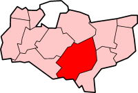
| District | Ashford |
| Shire county | Kent |
| Region | South East |
| Country | England |
| Sovereign state | United Kingdom |
| Post town | TONBRIDGE |
| Postcode district | TN26 |
| Dialling code | 01233 |
| Police | Kent |
| Fire | Kent |
| Ambulance | South East Coast |
| EU Parliament | South East England |
| UK Parliament | Ashford |
| List of places: UK • England • Kent | |
The village of Ruckinge is located in Kent. It lies seven miles southeast of Ashford on the B2067 Hamstreet to Hythe road. It is the centre of a civil parish of the same name, which also includes the scattered community of Bromley Green. The population of the parish is 727 persons, and is divided in two (Upper and Lower) by a belt of woodland.
The village has a public house (Blue Anchor), church (St Mary Magdalene) and Methodist chapel. The Royal Military Canal runs to the south of Ruckinge. Ruckinge's history includes smuggling, once rife on Romney Marsh and it is rumoured that the notorious Ransley brothers were buried in Ruckinge churchyard after being hanged at Penenden Heath, Maidstone.
Until the early 1990s Ruckinge had a village shop/post office. Today the nearest shops and railway station are in nearby Hamstreet. Ruckinge does have lively Scout and Guide associations which it shares with the larger village.
Sources[]
External links[]
 Media related to Ruckinge at Wikimedia Commons
| |||||||||||
| This Kent location article is a stub. You can help by expanding it. |
| This page uses content from the English language Wikipedia. The original content was at Ruckinge. The list of authors can be seen in the page history. As with this Familypedia wiki, the content of Wikipedia is available under the Creative Commons License. |