| ||||||||||||||
| Scott County, Tennessee | |
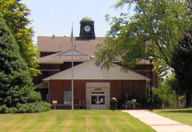 Scott County Courthouse in Huntsville
| |
Location in the state of Tennessee | |
 Tennessee's location in the U.S. | |
| Founded | 1849 |
|---|---|
| Named for | Winfield Scott[1] |
| Seat | Huntsville |
| Largest town | Oneida |
| Area - Total - Land - Water |
533 sq mi (1,380 km²) 532 sq mi (1,378 km²) 0.9 sq mi (2 km²), 0.2 |
| Population - (2020) - Density |
21,850 42/sq mi (16/km²) |
| Congressional district | 3rd |
| Time zone | Eastern: UTC-5/-4 |
| Website | www.scottcounty.com |
Scott County is a county located in the U.S. state of Tennessee. Its county seat is Huntsville.[2] Scott County is known for having seceded from Tennessee in protest of the state's decision to join the Confederacy during the Civil War, and subsequently forming The Free and Independent State of Scott.
History[]
Scott County was formed in 1849 from portions of Anderson, Campbell, Fentress and Morgan counties. It is named for U.S. Army General Winfield Scott, a hero of the Mexican War.[1]
State of Scott[]
During the Civil War, the county was a Southern Unionist bastion, voting against secession from the Union in Tennessee's June 1861 referendum by a higher percentage (521 to 19, or 96%) than in any other Tennessee county.[1][3] This sentiment was encouraged by a June 4, 1861, speech in Huntsville by U.S. Senator Andrew Johnson.[1][4] In 1861, the county assembly officially enacted a resolution seceding from the state of Tennessee, and thus the Confederacy, forming the "Free and Independent State of Scott," also known simply as the "State of Scott." The county remained a pro-Union enclave throughout the war.[1][5] Ulysses S. Grant received over 90% of the vote in Scott County during both the 1868 United States presidential election and the 1872 United States presidential election.
The proclamation was finally repealed, over a hundred years later, by Scott County in 1986.[6]
Geography[]

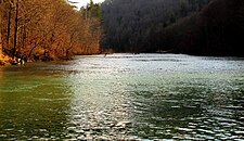
Big South Fork of the Cumberland


US-27 at the Tennessee-Kentucky state line, looking south into Scott County
According to the U.S. Census Bureau, the county has a total area of 533 square miles (1,380 km2), of which 532 square miles (1,380 km2) is land and 0.9 square miles (2.3 km2) (0.2%) is water.[7] The county is located in a relatively hilly area atop the Cumberland Plateau. In the southwestern part of the county, the Clear Fork and New River converge to form the Big South Fork of the Cumberland River, a major tributary of the Cumberland River, and the focus of a national river and recreation area.
U.S. Route 27 is the county's primary north–south road. State Route 63 connects Scott County with Campbell County to the east. State Route 52 connects Scott County with the Fentress County area to the west. A portion of State Route 297 connects Oneida with the Big South Fork Recreation Area. State Route 456 is another major road in the area.
Adjacent counties[]
- McCreary County, Kentucky (north)
- Campbell County (east)
- Anderson County (southeast)
- Morgan County (southwest)
- Fentress County (west/CST Border)
- Pickett County (northwest/CST Border)
- Wayne County, Kentucky (northwest)
National protected area[]
- Big South Fork National River and Recreation Area (part)
State protected areas[]
- North Cumberland Wildlife Management Area (part)
- Scott State Forest (part)
- Twin Arches State Natural Area (part)
Demographics[]
| Historical populations | |||
|---|---|---|---|
| Census | Pop. | %± | |
| 1850 | 1,905 | ||
| 1860 | 3,519 | 84.7% | |
| 1870 | 4,054 | 15.2% | |
| 1880 | 6,021 | 48.5% | |
| 1890 | 9,794 | 62.7% | |
| 1900 | 11,077 | 13.1% | |
| 1910 | 12,947 | 16.9% | |
| 1920 | 13,411 | 3.6% | |
| 1930 | 14,080 | 5.0% | |
| 1940 | 15,966 | 13.4% | |
| 1950 | 17,362 | 8.7% | |
| 1960 | 15,413 | −11.2% | |
| 1970 | 14,762 | −4.2% | |
| 1980 | 19,259 | 30.5% | |
| 1990 | 18,358 | −4.7% | |
| 2000 | 21,127 | 15.1% | |
| 2010 | 22,228 | 5.2% | |
1790-1960[8] 1900-1990[9]
1990-2000[10] 2010-2020[11]
}}
 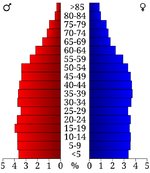 Age pyramid Scott County[12] |
2020 census[]
| Race | Number | Percentage |
|---|---|---|
| White (non-Hispanic) | 20,957 | 95.91% |
| Black or African American (non-Hispanic) | 32 | 0.15% |
| Native American | 36 | 0.16% |
| Asian | 51 | 0.23% |
| Other/Mixed | 569 | 2.6% |
| Hispanic or Latino | 205 | 0.94% |
As of the 2020 United States census, there were 21,850 people, 8,664 households, and 6,059 families residing in the county.
2000 census[]
At the 2000 census,[14] there were 21,127 people, 8,203 households and 6,012 families residing in the county. The population density was 40 per square mile (15/km2). There were 8,909 housing units at an average density of 17 per square mile (6/km2). The racial makeup of the county was 98.53% White, 0.09% Black or African American, 0.25% Native American, 0.12% Asian, 0.10% from other races, and 0.91% from two or more races. 0.57% of the population were Hispanic or Latino of any race.
There were 8,203 households, of which 35.70% had children under the age of 18 living with them, 57.20% were married couples living together, 11.80% had a female householder with no husband present, and 26.70% were non-families. 24.30% of all households were made up of individuals, and 9.50% had someone living alone who was 65 years of age or older. The average household size was 2.55 and the average family size was 3.02.
26.10% of the population were under the age of 18, 10.30% from 18 to 24, 28.70% from 25 to 44, 23.60% from 45 to 64, and 11.30% who were 65 years of age or older. The median age was 35 years. For every 100 females there were 97.40 males. For every 100 females age 18 and over, there were 94.00 males.
The median household income was $24,093 and the median family income was $28,595. Males had a median income of $24,721 compared with $19,451 for females. The per capita income for the county was $12,927. About 17.60% of families and 20.20% of the population were below the poverty line, including 24.10% of those under age 18 and 17.10% of those age 65 or over.
Scott County, a part of the Cumberland Plateau, includes the majority of the Big South Fork National River and Recreation Area.
2010 ancestry[]
As of 2010, the largest self-reported ancestry groups in the county were:[15]
- American - 18.1%
- English - 16.7%
- Irish - 8.4%
- German - 4.2%
- Scots-Irish - 3.2%
- Scottish - 2.0%
- Italian - 1.2%
- Polish - 1.1%
Education[]
Scott County School District (Website)
- Burchfield Elementary School; "The Rams" (Website) Archived February 3, 2013, at the Wayback Machine
- Farview Elementary School; "The Rebels" (Website) Archived March 28, 2022, at the Wayback Machine
- Huntsville Elementary School; "The Bears" (Website) Archived October 14, 2021, at the Wayback Machine
- Huntsville Middle School; "The Bears" (Website)
- Robbins Elementary School; "The Hawks" (Website)
- Scott High School; "The Highlanders" (Website) Archived November 2, 2021, at the Wayback Machine
- Winfield Elementary School; "The Bobcats" (Website) Archived July 23, 2020, at the Wayback Machine
Oneida Special School District (Website)
- Oneida Elementary School; "The Indians" (Website)
- Oneida Middle School; "The Indians" (Website)
- Oneida High School; "The Indians" (Website)
Private schools
- Landmark Christian School
Public safety[]
Includes the Scott County Sheriff Department; Oneida and Winfield Police Department; a full-time ambulance service with two stations; a volunteer rescue squad; and nine volunteer fire stations placed throughout the county.
Media[]
- The Independent Herald[16]
- The Scott County News
- Hive 105, WBNT-FM
Communities[]
Towns[]
- Huntsville (county seat)
- Oneida
- Winfield
Census-designated places[]
- Elgin
- Helenwood
- Robbins
Unincorporated communities[]
- Isham
- Montgomery
- New River
- Rugby (partial)
- Winona
Politics[]
| Year | Republican | Democratic | Third party | |||
|---|---|---|---|---|---|---|
| No. | % | No. | % | No. | % | |
| 2020 | 8,004 | 88.42% | 986 | 10.89% | 62 | 0.68% |
| 2016 | 6,044 | 84.85% | 934 | 13.11% | 145 | 2.04% |
| 2012 | 5,117 | 76.74% | 1,452 | 21.78% | 99 | 1.48% |
| 2008 | 4,931 | 72.70% | 1,720 | 25.36% | 132 | 1.95% |
| 2004 | 4,509 | 59.11% | 3,086 | 40.46% | 33 | 0.43% |
| 2000 | 3,579 | 54.10% | 2,967 | 44.85% | 69 | 1.04% |
| 1996 | 2,646 | 46.94% | 2,506 | 44.46% | 485 | 8.60% |
| 1992 | 3,011 | 46.91% | 2,730 | 42.54% | 677 | 10.55% |
| 1988 | 2,562 | 61.10% | 1,611 | 38.42% | 20 | 0.48% |
| 1984 | 3,107 | 62.63% | 1,810 | 36.48% | 44 | 0.89% |
| 1980 | 3,014 | 62.38% | 1,724 | 35.68% | 94 | 1.95% |
| 1976 | 2,432 | 51.42% | 2,260 | 47.78% | 38 | 0.80% |
| 1972 | 2,775 | 79.24% | 679 | 19.39% | 48 | 1.37% |
| 1968 | 2,406 | 58.24% | 991 | 23.99% | 734 | 17.77% |
| 1964 | 2,406 | 54.52% | 2,007 | 45.48% | 0 | 0.00% |
| 1960 | 3,301 | 74.84% | 1,098 | 24.89% | 12 | 0.27% |
| 1956 | 3,282 | 79.10% | 842 | 20.29% | 25 | 0.60% |
| 1952 | 3,274 | 73.82% | 1,161 | 26.18% | 0 | 0.00% |
| 1948 | 2,016 | 66.67% | 972 | 32.14% | 36 | 1.19% |
| 1944 | 1,971 | 69.60% | 850 | 30.01% | 11 | 0.39% |
| 1940 | 2,187 | 59.93% | 1,448 | 39.68% | 14 | 0.38% |
| 1936 | 2,012 | 70.67% | 827 | 29.05% | 8 | 0.28% |
| 1932 | 1,890 | 64.29% | 1,025 | 34.86% | 25 | 0.85% |
| 1928 | 2,700 | 91.59% | 244 | 8.28% | 4 | 0.14% |
| 1924 | 1,611 | 77.71% | 274 | 13.22% | 188 | 9.07% |
| 1920 | 2,537 | 90.54% | 221 | 7.89% | 44 | 1.57% |
| 1916 | 1,486 | 82.24% | 206 | 11.40% | 115 | 6.36% |
| 1912 | 123 | 7.49% | 160 | 9.74% | 1,359 | 82.76% |
| 1908 | 1,932 | 89.99% | 190 | 8.85% | 25 | 1.16% |
| 1904 | 1,567 | 90.26% | 166 | 9.56% | 3 | 0.17% |
| 1900 | 1,498 | 89.59% | 171 | 10.23% | 3 | 0.18% |
| 1896 | 1,691 | 88.67% | 209 | 10.96% | 7 | 0.37% |
| 1892 | 1,198 | 83.43% | 156 | 10.86% | 82 | 5.71% |
| 1888 | 1,418 | 89.46% | 164 | 10.35% | 3 | 0.19% |
| 1884 | 969 | 88.17% | 130 | 11.83% | 0 | 0.00% |
| 1880 | 582 | 82.09% | 127 | 17.91% | 0 | 0.00% |
Notable people[]
- Howard Baker Sr.- U.S. Representative for Tennessee's 2nd congressional district.
- Howard Baker Jr. - U.S. senator from Tennessee; first Republican elected to the U.S. senate from Tennessee since Reconstruction.
See also[]
- National Register of Historic Places listings in Scott County, Tennessee
References[]
- ^ a b c d e Margaret D. Binnicker, Scott County, Tennessee Encyclopedia of History and Culture, accessed April 17, 2011
- ^ "Find a County". National Association of Counties. http://www.naco.org/Counties/Pages/FindACounty.aspx.
- ^ Oliver Perry Temple, East Tennessee and the Civil War (R. Clarke Company, 1899), p. 199.
- ^ Astor, Aaron (2011-06-11), "The Switzerland of America", Opinionator: Exclusive On-Line Commentary From The Times (New York Times), http://opinionator.blogs.nytimes.com/2011/06/07/the-switzerland-of-america/, retrieved 2011-12-21
- ^ Evan Andrews, "6 Southern Unionist Strongholds During the Civil War, History.com, 13 January 2015.
- ^ History of Scott County, Tennessee. Retrieved at Web Archive 16 February 2013.
- ^ "2010 Census Gazetteer Files". United States Census Bureau. August 22, 2012. http://www2.census.gov/geo/docs/maps-data/data/gazetteer/counties_list_47.txt.
- ^ "Historical Census Browser". University of Virginia Library. http://mapserver.lib.virginia.edu.
- ^ Forstall, Richard L., ed (March 27, 1995). "Population of Counties by Decennial Census: 1900 to 1990". United States Census Bureau. https://www.census.gov/population/cencounts/tn190090.txt.
- ^ "Census 2000 PHC-T-4. Ranking Tables for Counties: 1990 and 2000". United States Census Bureau. April 2, 2001. https://www.census.gov/population/www/cen2000/briefs/phc-t4/tables/tab02.pdf.
- ^ "State & County hhusushbQuickFacts". United States Census Bureau. http://quickfacts.census.gov/qfd/states/47/47151.html.
- ^ Based on 2000 census data
- ^ "Explore Census Data". https://data.census.gov/cedsci/table?g=0500000US47151&tid=DECENNIALPL2020.P2.
- ^ "U.S. Census website". United States Census Bureau. https://www.census.gov.
- ^ https://factfinder.census.gov/bkmk/table/1.0/en/ACS/10_5YR/DP02/0500000US47137%7C0500000US47151%7C0500000US47187
- ^ Independent Herald official website. Retrieved: 22 March 2013.
- ^ Leip, David. "Dave Leip's Atlas of U.S. Presidential Elections". http://uselectionatlas.org/RESULTS.
External links[]
- Official website
- Scott County Chamber of Commerce
- Scott County at Curlie
- Scott Co, TN Genealogy
- Scott county Landforms

|
Pickett County | McCreary County, Kentucky |
| |
| Fentress County | Campbell County | |||
 Scott County, Tennessee | ||||
| Morgan County | Anderson County |
Template:Scott County, Tennessee
|
| This page uses content from the English language Wikipedia. The original content was at Scott County, Tennessee. The list of authors can be seen in the page history. As with this Familypedia wiki, the content of Wikipedia is available under the Creative Commons License. |