| ||||||||||||||
| Somerset County, New Jersey | ||
| ||
 Location in the state of New Jersey | ||
 New Jersey's location in the U.S. | ||
| Founded | May 14, 1688[1] | |
|---|---|---|
| Seat | Somerville | |
| Largest city | Franklin Township | |
| Area - Total - Land - Water |
305 sq mi (790 km²) 305 sq mi (790 km²) 0 sq mi (0 km²), 0.12% | |
| Population - (2020) - Density |
345,361 1,059/sq mi (409/km²) | |
| Website | www.co.somerset.nj.us | |
Somerset County is a county located in the U.S. state of New Jersey. In 2020, the population was 345,361. It is part of the New York Metropolitan Area. Its county seat is Somerville[2].
Somerset County is the ninth-wealthiest county in the United States by per capita income and the highest in New Jersey.[3] Somerset County has the tenth-highest personal per capita income of any U.S. county and the second-highest in New Jersey.[4] The county also ranks sixth in the United States in terms of median income.[5]
Somerset County was created on May 14, 1688, from portions of Middlesex County.[1]
Geography[]
According to the U.S. Census Bureau, the county has a total area of 305 square miles (790 km²) of which 305 square miles (789 km²) is land and 0 square miles (1 km²) (0.12%) is water.
The high point is on Mine Mountain in Bernardsville, at approximately 860 feet (262 m) above sea level. The lowest point is just above sea level on the Raritan River at the Middlesex County line.
Adjacent counties[]
- Morris County, New Jersey – north
- Union County, New Jersey – east
- Middlesex County, New Jersey – southeast
- Mercer County, New Jersey – south
- Hunterdon County, New Jersey – west

|
Morris County |
| ||
| Hunterdon County | Union County | |||
 Somerset County, New Jersey | ||||
| Mercer County | Middlesex County |
Demographics[]
| Historical populations | |||
|---|---|---|---|
| Census | Pop. | %± | |
| 1790 | 12,296 | ||
| 1800 | 12,815 | 4.2% | |
| 1810 | 14,725 | 14.9% | |
| 1820 | 16,506 | 12.1% | |
| 1830 | 17,689 | 7.2% | |
| 1840 | 17,455 | * | −1.3% |
| 1850 | 19,692 | 12.8% | |
| 1860 | 22,057 | 12.0% | |
| 1870 | 23,510 | 6.6% | |
| 1880 | 27,162 | 15.5% | |
| 1890 | 28,311 | 4.2% | |
| 1900 | 32,948 | 16.4% | |
| 1910 | 38,820 | 17.8% | |
| 1920 | 47,991 | 23.6% | |
| 1930 | 65,132 | 35.7% | |
| 1940 | 74,390 | 14.2% | |
| 1950 | 99,052 | 33.2% | |
| 1960 | 143,913 | 45.3% | |
| 1970 | 198,372 | 37.8% | |
| 1980 | 203,129 | 2.4% | |
| 1990 | 240,279 | 18.3% | |
| 2000 | 297,490 | 23.8% | |
| 2010 | 323,444 | 8.7% | |
| * lost territory | |||
At the 2000 census[9], there were 297,490 people, 108,984 households and 78,359 families residing in the county. The population density was 976 per square mile (377/km²). There were 112,023 housing units at an average density of 368 per square mile (142/km²). The racial makeup of the county was 79.34% White, 7.53% Black or African American, 0.13% Native American, 8.38% Asian, 0.04% Pacific Islander, 2.74% from other races, and 1.83% from two or more races. 8.68% of the population were Hispanic or Latino of any race. 17.6% were of Italian, 11.4% Irish, 9.3% German and 7.5% Polish ancestry according to Census 2000.
There were 108,984 households of which 36.20% had children under the age of 18 living with them, 60.60% were married couples living together, 8.20% had a female householder with no husband present, and 28.10% were non-families. 22.80% of all households were made up of individuals and 7.00% had someone living alone who was 65 years of age or older. The average household size was 2.69 and the average family size was 3.19.
Age distribution was 25.50% under the age of 18, 5.90% from 18 to 24, 33.80% from 25 to 44, 23.50% from 45 to 64, and 11.20% who were 65 years of age or older. The median age was 37 years. For every 100 females there were 95.40 males. For every 100 females age 18 and over, there were 92.10 males.
The median household income was $76,933 and the median family income was $90,605. (These figures had risen to $94,036 and $109,488 respectively in 2007 estimates[10]). Males had a median income of $60,602 versus $41,824 for females. The per capita income for the county was $37,970. The poverty rate is 1.7%, the lowest of any county in the United States with 250,000 or more people. Of the total population, 3.80% of those under the age of 18 and 4.90% of those 65 and older were living below the poverty line.
History[]
Somerset County is one of America's oldest counties, and is named after the English county of Somerset. The area was first settled in 1681, in the vicinity of Bound Brook, and the county was established by charter on May 22, 1688. Most of the early residents were Dutch. General George Washington and his troops marched through the county on several occasions and slept in many of the homes located throughout the area. Somerset County also played an important part during both World War I and World War II with weapons depots and the manufacturing of the army's woolen blankets.
For much of its history, Somerset County was primarily an agricultural county. In the late 19th century, the Somerset Hills area of Somerset County became a popular country home for wealthy industrialists. The area is still the home of wealthy pharmaceutical industrialists.[11]
In the 1960s, townships that were once exclusively agricultural were quickly transformed into suburban communities. Examples include Bridgewater Township[12] and the Watchung Hills communities of Watchung, Green Brook and Warren Township.[13][14][15] This growth was aided by the development of the county's very strong pharmaceutical and technology presence. Indeed, Warren Township used to be considered "the greenest place in New Jersey." [13] More recently, there has been an influx of New York City commuters who use New Jersey Transit's Raritan Valley Line and Gladstone Branch or use Interstate 78.
Government[]
As of November 2, 2020, there were a total of 258,975 registered voters in Somerset County, of whom 90.014 (34.8%) were registered as Democrats, 65,262 (25.2%) were registered as Republicans and 101,149 (39.1%) were registered as Unaffiliated. There were 2,550 (1.0%) voters registered to other parties.[16] Among the county's 2010 Census population, 67.1% were registered to vote, including 75.% of those ages 18 and over.[17][18]
In the 2004 presidential election, George W. Bush carried Somerset County by a 4.3% margin over John Kerry, with Kerry carrying the state by 6.7% over Bush. However, in 2008, Barack Obama became the first Democratic presidential nominee to carry the county since Lyndon Johnson in 1964, and only the second since 1936. Obama won Somerset by a 6.1% margin over John McCain, with Obama carrying the state by 15.5% over McCain.[19] Somerset's growing Democratic trend at the presidential level has largely been spurred by the rapid growth of the overwhelmingly Democratic Franklin Township in the county's southeast corner.
In the 2009 Gubernatorial Election, Republican Chris Christie received 56% of the vote, defeating Democrat Jon Corzine, who received around 34%. In the 2012 presidential election, the county was carried by Barack Obama, winning 52.8% of the vote to Mitt Romney's 47.2%, a 5.6% gap that represented a 0.3% drop off for Obama from his 2008 margin of victory in the county.
| Year | Republican | Democratic | Third party | |||
|---|---|---|---|---|---|---|
| No. | % | No. | % | No. | % | |
| 2020 | 71,996 | 38.52% | 111,173 | 59.49% | 3,722 | 1.99% |
| 2016 | 65,505 | 41.70% | 85,689 | 54.55% | 5,898 | 3.75% |
| 2012 | 66,603 | 46.52% | 74,592 | 52.10% | 1,985 | 1.39% |
| 2008 | 70,085 | 46.28% | 79,321 | 52.38% | 2,024 | 1.34% |
| 2004 | 72,508 | 51.69% | 66,476 | 47.39% | 1,295 | 0.92% |
| 2000 | 59,725 | 49.61% | 56,232 | 46.71% | 4,420 | 3.67% |
| 1996 | 51,869 | 45.93% | 50,673 | 44.87% | 10,387 | 9.20% |
| 1992 | 56,044 | 46.39% | 42,867 | 35.48% | 21,902 | 18.13% |
| 1988 | 67,658 | 63.71% | 37,406 | 35.22% | 1,129 | 1.06% |
| 1984 | 66,303 | 66.77% | 31,924 | 32.15% | 1,069 | 1.08% |
| 1980 | 52,591 | 57.21% | 29,470 | 32.06% | 9,867 | 10.73% |
| 1976 | 51,260 | 57.15% | 36,258 | 40.43% | 2,173 | 2.42% |
| 1972 | 56,524 | 66.03% | 26,537 | 31.00% | 2,544 | 2.97% |
| 1968 | 42,459 | 54.11% | 27,580 | 35.14% | 8,436 | 10.75% |
| 1964 | 28,416 | 39.32% | 43,659 | 60.41% | 195 | 0.27% |
| 1960 | 36,200 | 55.81% | 28,489 | 43.92% | 174 | 0.27% |
| 1956 | 37,930 | 71.85% | 14,529 | 27.52% | 330 | 0.63% |
| 1952 | 31,239 | 63.34% | 18,007 | 36.51% | 74 | 0.15% |
| 1948 | 22,034 | 59.77% | 14,104 | 38.26% | 724 | 1.96% |
| 1944 | 20,266 | 58.29% | 14,467 | 41.61% | 37 | 0.11% |
| 1940 | 20,169 | 54.87% | 16,490 | 44.86% | 96 | 0.26% |
| 1936 | 15,806 | 49.57% | 15,987 | 50.14% | 94 | 0.29% |
| 1932 | 15,317 | 54.18% | 12,345 | 43.66% | 611 | 2.16% |
| 1928 | 16,386 | 66.66% | 8,120 | 33.03% | 74 | 0.30% |
| 1924 | 12,986 | 71.12% | 4,143 | 22.69% | 1,131 | 6.19% |
| 1920 | 10,962 | 71.02% | 4,192 | 27.16% | 281 | 1.82% |
| 1916 | 4,707 | 55.70% | 3,653 | 43.23% | 91 | 1.08% |
| 1912 | 2,068 | 27.94% | 3,146 | 42.50% | 2,188 | 29.56% |
| 1908 | 5,045 | 59.46% | 3,269 | 38.53% | 170 | 2.00% |
| 1904 | 4,633 | 57.57% | 3,195 | 39.70% | 219 | 2.72% |
| 1900 | 4,437 | 56.32% | 3,184 | 40.42% | 257 | 3.26% |
| 1896 | 4,388 | 60.18% | 2,608 | 35.77% | 295 | 4.05% |
Legal[]
In 1996, Nicholas L. Bissell, Jr., the then county prosecutor, was charged with embezzlement, tax fraud and abuse of power. He fled to Laughlin, Nevada, near Las Vegas and took his own life when the federal authorities attempted to arrest him.[21]
Taxation[]
Based on IRS data for the 2004 tax year, Somerset County had the ninth highest average federal income tax liability per return in the country. Average tax liability was $16,502, representing 16.8% of Adjusted Gross Income.[22]
Education[]
Somerset County is home to two colleges:
- Raritan Valley Community College, North Branch (public)
- Somerset Christian College, Zarephath, in Franklin Township (private)
Somerset County Technology Institute Bridgewater, New Jersey. Somerset County Technology Institute is a public institution providing quality post-secondary (adult) education in the areas of General and Computer Technology, Allied Health, Office Administration, Cosmetology and Commercial Art & Multimedia.
Alma White College, which closed in 1978, was a private college located in Zarephath, located in the building now occupied by Somerset Christian College.
Somerset is also home to Somerset Hills Learning Institute, a state-of-the-art program dedicated to educating children on the autism spectrum by utilizing the principles of ABA.
Rutgers, The State University of New Jersey has a partnership with Raritan Valley Community College located in North Branch, NJ. This program allows students who have an Associate's degree to complete a Bachelor's degree by attending Rutgers classes off campus at Raritan Valley Community College's North Branch campus.
Recreation[]
Somerset County boasts a number of beautiful county parks, including but not limited to: Lord Stirling Park (part of the Great Swamp National Wildlife Refuge), Colonial Park (with a lovely rose garden), Washington Valley Park (with biking and hiking trails), the Sourland Mountain Preserve (hiking and mountain biking trails), and the newest park in development called Raritan River Greenway (which is being developed along the Raritan River in Bridgewater Township).
The southeastern portion of Somerset County in Franklin Township also includes the Delaware and Raritan Canal State Park, which provides hiking, biking and boating.
Trump National Golf Club in Bedminster is an exclusive golf club owned by celebrity businessman Donald Trump.
Municipalities[]
The following is a list of the municipalities in Somerset County. Other, unincorporated areas in the county are listed below their parent municipality (or municipalities, as the case may be). Most of these areas are census-designated places that have been created by the United States Census Bureau for enumeration purposes within a Township. Other communities, historical areas, unincorporated areas, and enclaves that exist within a municipality are marked as non-CDP next to the name.

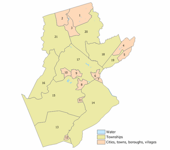
Index map of Somerset County municipalities (click to see index key)
- Bedminster Township
- Lamington non-CDP
- Pluckemin non-CDP
- Pottersville non-CDP
- Bernards Township
- Basking Ridge non-CDP
- Liberty Corner non-CDP
- Lyons non-CDP
- West Millington non-CDP
- Bernardsville
- Bound Brook
- Branchburg Township
- Neshanic Station non-CDP
- North Branch non-CDP
- Bridgewater Township
- Bradley Gardens non-CDP
- Green Knoll non-CDP
- Finderne non-CDP
- Martinsville non-CDP
- Middlebrook Heights non-CDP
- Far Hills
- Franklin Township
- East Millstone non-CDP
- Franklin Park non-CDP
- Griggstown non-CDP
- Kingston
- Middlebush non-CDP
- Pleasant Plains non-CDP
- Six Mile Run non-CDP
- Somerset
- Weston non-CDP
- Zarephath non-CDP
- Green Brook Township
- Washington Rock non-CDP
- Hillsborough Township
- Belle Mead non-CDP
- Blackwells Mills non-CDP
- Flagtown non-CDP
- Neshanic non-CDP
- South Branch non-CDP
- Manville
- Millstone
- Montgomery Township
- Belle Mead non-CDP
- Blawenburg non-CDP
- Harlingen non-CDP
- Skillman non-CDP
- North Plainfield
- Peapack-Gladstone
- Gladstone non-CDP
- Raritan
- Rocky Hill
- Somerville
- South Bound Brook
- Warren Township
- Mount Bethel non-CDP
- Watchung
See also[]
- Duke Gardens
- Hall-Mills Murder
- Meadows Foundation
- Middlebush Giant
- National Register of Historic Places listings in Somerset County, New Jersey
- Old Dutch Parsonage
- Rockingham
- Six-Mile Run Reservoir
- Trump National Golf Club of Bedminster, New Jersey
References[]
- ^ a b "The Story of New Jersey's Civil Boundaries: 1606–1968", John P. Snyder, Bureau of Geology and Topography; Trenton, New Jersey; 1969. p. 221.
- ^ "Find a County". National Association of Counties. http://www.naco.org/Counties/Pages/FindACounty.aspx. Retrieved 2011-06-07.
- ^ Census 2000 Demographic Profiles
- ^ 250 Highest Per Capita Personal Incomes of the 3111 Counties in the United States, 2006, Bureau of Economic Analysis. Statistics for year 2006 Accessed May 2, 2008.
- ^ Woolsey, Matt. "Complete List: America's Richest Counties", Forbes, January 22, 2008. Accessed May 2, 2008
- ^ "New Jersey Resident Population by County: 1880 – 1930". http://www.wnjpin.net/OneStopCareerCenter/LaborMarketInformation/lmi01/poptrd5.htm.
- ^ "Geostat Center: Historical Census Browser". University of Virginia Library. http://fisher.lib.virginia.edu/collections/stats/histcensus/. Retrieved 2007-03-02.
- ^ "The Counties and Most Populous Cities and Townships in 2010 in New Jersey: 2000 and 2010". U.S. Census Bureau. 2011-02-03. http://2010.census.gov/news/xls/st34-final_newjersey.xls. Retrieved 2011-02-05.
- ^ "American FactFinder". United States Census Bureau. http://factfinder.census.gov. Retrieved 2008-01-31.
- ^ http://factfinder.census.gov/servlet/ACSSAFFFacts?_event=ChangeGeoContext&geo_id=05000US34035&_geoContext=01000US%7C04000US34%7C05000US34025&_street=&_county=somerset&_cityTown=somerset&_state=04000US34&_zip=&_lang=en&_sse=on&ActiveGeoDiv=geoSelect&_useEV=&pctxt=fph&pgsl=010&_submenuId=factsheet_1&ds_name=ACS_2007_3YR_SAFF&_ci_nbr=null&qr_name=null®=null%3Anull&_keyword=&_industry=
- ^ Clemence, Sara. "Home of the Week: Peapack Palace", Forbes, March 14, 2005. Accessed May 22, 2008. "It was once the country home of some of the 19th century's wealthiest families, and modern-day residents now include pharmaceuticals and chemicals barons."
- ^ The History of Bridgewater Township, Bridgewater Township, New Jersey. Accessed May 22, 2008. "In the early years, Bridgewater was known as a farming town."
- ^ a b http://www.warrennj.org/ ""Once described as "the greenest place in New Jersey", Warren Township residents and elected officials are working to keep its rural character and charm while recognizing that there will be growth due to the town's beauty, favorable property taxes and strategic location. Less than 35 miles to Manhattan makes Warren Township a favorite suburb for commuters to New York City."
- ^ http://greenbrooknj.com/main6.htm "As the traffic through the corridor expanded, Green Brook Township developed from a quiet farming community, which it had been for nearly two hundred years, into the suburban community that it is today."
- ^ http://www.watchungnj.com/ Watchung was settled in the early eighteenth century and grew slowly until recent years. In 1960 the population was 3,312 and in 2000 it was 5,613."
- ^ "NJ Voter Registration by County". https://www.state.nj.us/state/elections/assets/pdf/svrs-reports/2020/2020-1103-voter-registration-by-county.pdf.
- ^ Statewide Voter Registration Summary Archived December 22, 2014, at the Wayback Machine, New Jersey Department of State Division of Elections, as of October 31, 2014. Accessed May 11, 2015.
- ^ GCT-P7: Selected Age Groups: 2010 - State -- County / County Equivalent from the 2010 Census Summary File 1 for New Jersey, United States Census Bureau. Accessed May 11, 2015.
- ^ U.S. Election Atlas
- ^ Leip, David. "Dave Leip's Atlas of U.S. Presidential Elections". http://uselectionatlas.org/RESULTS.
- ^ Glaberson, William (December 1, 1996). "In Prosecutor's Rise and Fall, a Story of Ambition, Deceit and Shame.". New York Times. http://query.nytimes.com/gst/fullpage.html?sec=health&res=9D03EEDA123CF932A35751C1A960958260. Retrieved 2007-06-21. "When Nicholas L. Bissell Jr. put a gun in his mouth and pulled the trigger in a $20 room on a neon strip here, it was almost the cliche ending to an ambitious man's rise and fall. An unexceptional child of New Jersey's modest suburbs, he rose to become a feared prosecutor in Somerset County known for his swaggering assault on drug dealers. Loyal followers said he had a magnetic personality. He capitalized on the attention and he craved more."
- ^ Biggest Income Tax Burdens: Top 10 Places, CNN Money, accessed April 28, 2007.
External links[]
- Somerset County website
- Somerset County National Historic Places
- Somerset County Parks Commission
- The Historical Society of the Somerset Hills – Includes Bedminster, Bernardsville, Basking Ridge, Far Hills, Peapack/Gladstone
- Hills List is a local informational website for the Bedminster and Basking Ridge areas
- Rutgers at Raritan Valley Community College
| ||||||||||||||||||||

| |||||||||||||||||
| ||||||||||||||||||||||
| This page uses content from the English language Wikipedia. The original content was at Somerset County, New Jersey. The list of authors can be seen in the page history. As with this Familypedia wiki, the content of Wikipedia is available under the Creative Commons License. |