| Main | Births etc |
|---|
| South Brisbane Brisbane, | |||||||||||||
 South Brisbane is dominated by riverside high-rise apartments. | |||||||||||||

South Brisbane | |||||||||||||
| Population: | 5416 [1] | ||||||||||||
| Postcode: | 4101 | ||||||||||||
| Area: | 2.0 km² (0.8 sq mi) | ||||||||||||
| LGA: | City of Brisbane (The Gabba Ward) | ||||||||||||
| State District: | South Brisbane | ||||||||||||
| Federal Division: | Griffith | ||||||||||||
| |||||||||||||
South Brisbane is an inner city suburb of Brisbane, Australia on the southern bank of the Brisbane River, directly connected to the central business district by the Kurilpa, Victoria and Goodwill bridges. Its population was estimated to be 5,416 at the 2011 Australian Census.[1]
Modern public transport services include suburban train stations at South Brisbane and South Bank and South East Busway stations at Cultural Centre, South Bank, and Mater Hill. CityCat ferry services link South Brisbane to other riverside suburbs.
Demographics[]
In the 2011 census the population of South Brisbane was 5,416, 48.8% female and 51.2% male. The median age of the South Brisbane population was 30 years, seven years below the Australian median. One-third of the population (33.3%) were aged in their twenties, compared to 13.8% nationally. 44.2% of people living in South Brisbane were born in Australia, compared to the national average of 69.8%.[1] The other top responses for country of birth were England 3.8%, New Zealand 3.7%, China 3.3%, Korea, Republic of 3%, India 2%. 57.2% of people spoke only English at home; the next most popular languages were 5.5% Mandarin, 2.8% Korean, 2.7% Cantonese, 2.1% Greek, 1.9% Arabic. The most common religious affiliation was "No Religion" (30%); the next most common responses were Catholic (19%), Anglican (8.5%), Buddhism (4.6%) and Islam (3.8%).[1]
History[]


View of South Brisbane c.1895


View from River Terrace c.1895
Mater Health Services hospital was founded in 1906
Known, along with West End and Highgate Hill as Kurilpa (Water Rat) to the local indigenous people, the area remains important in indigenous life. Musgrave Park has been for many years a place of congregation for the Murri peoples of south-east Queensland. It is the site of a bora ring that has been buried.
European settlement commenced with the first land sales in 1843, followed by the development of wharves along the bank of the Brisbane River. Commercials buildings and hotels developed around the Russell Street area. By the 1850s there were over 100 residences in the area.[2]
South Brisbane Recreation Reserve (now known as Musgrave Park) was created in 1856.[2]
In 1867, it was proposed to build a public grammar school adjacent to the reserve.[3] However it was not until 1925 that Brisbane State High School moved to the site (having first been established in 1921 at old Normal School on the corner of Adelaide and Edward Street)[4]
In 1884, the railway to the south was opened with a terminus at South Brisbane. As a result, South Brisbane experienced a construction boom.
In 1888, South Brisbane became an independent municipality, initially as the Borough of South Brisbane and then becoming the City of South Brisbane in 1903. In 1925 the City of South Brisbane was amalgamated into the City of Greater Brisbane.[5]
The first electric tramway in Brisbane ran along Stanley Street in South Brisbane on 16 June 1897.[6]


South Brisbane Memorial Park, 2010
The South Brisbane Memorial Park commemorates those of South Brisbane who died in World War 1. On 20 May 1921 the South Brisbane City Council set aside a triangular block land bounded by Stanley Street, Vulture Street and Sidon Street opposite the South Brisbane Town Hall. On 6 August 1923 the park was dedicated Governor-General of Australia, Henry Forster.[7][8]
The suburb was previously heavily industrialised. Its regeneration began when it was selected as the location of World Expo '88, which was built on former wharves and industrial land. Following Expo '88, South Bank Parklands was built on the former Expo site. South Brisbane has emerged as fashionable, high density, modern residential area, given its proximity to the city centre and good public transport links.
Heritage listings[]
Being one of the older parts of Brisbane and an area of greater cultural heritage, South Brisbane has a number of heritage-listed buildings:
- South Bank Parklands: Allgas Building[9]
- South Bank Parklands: Byanda[10]
- South Bank Parklands: Nepal Peace Pagoda[11]
- South Bank Parklands: Plough Inn[12]
- 38 Dorchester Street: Coorooman[13]
- Grey Street: William Jolly Bridge[14]
- 133 Grey Street: South Brisbane railway station[15]
- 39 Melbourne Street: Queensland National Bank[16]
- 20 Merivale Street: St. Mary's Catholic Church[17]
- 88 Merivale Street: Brisbane South Girls and Infants School[18]
- 46 Montague Road: Coronation Hotel[19]
- 74 Stanley Street: Victoria Bridge Abutment[20]
- 412 Stanley Street: South Brisbane Dry Dock[21]
- 412 Stanley Street: South Brisbane Railway Easement[22]
- 472 Stanley Street: South Brisbane Library[23]
- 160 Vulture Street: St Andrew's Anglican Church[24]
- 253 Vulture Street: Cumbooquepa[25]
- 263 Vulture Street: South Brisbane Town Hall[26]
In addition, the Richard Randall Art Studio was originally located in South Brisbane, but was relocated to Toowong in 2007.[27]
Education[]
There are a number of educational institutions in South Brisbane including:
- Brisbane State High School
- Somerville House
- St Laurence's College
- Griffith University (Southbank Campus)
- Southbank Institute of Technology
South Bank[]
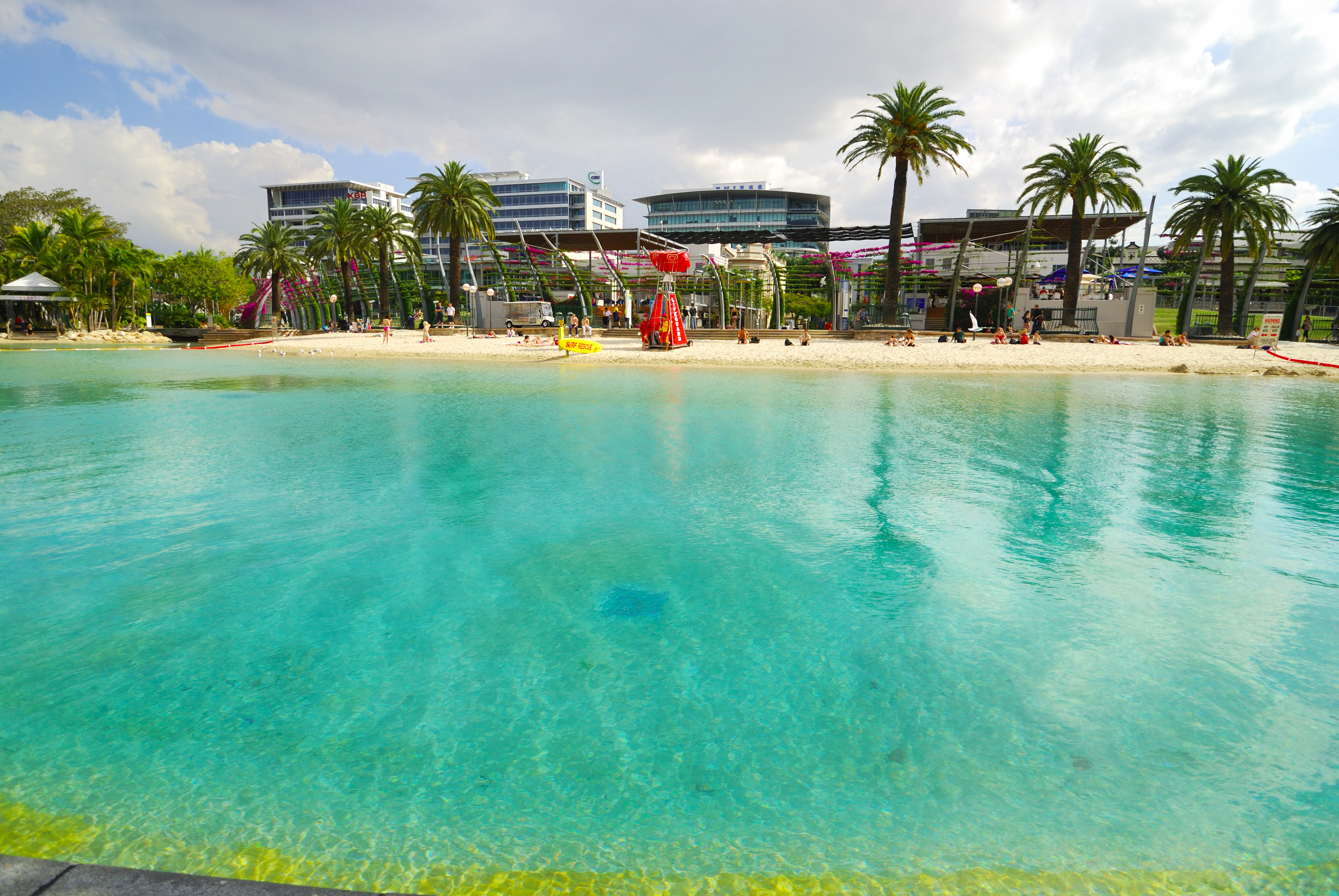

Streets Beach in the South Bank Parklands.
The South Bank precinct in South Brisbane contains many notable attractions.
South Bank Parklands[]
The South Bank Parklands are one of Brisbane's most popular tourist attractions. The parklands are home to many restaurants and café's as well as landmarks such as the Queensland Conservatorium, the Wheel of Brisbane, the Nepal Peace Pagoda, Streets Beach, and the Grand Arbour. Approximately 11,000,000 people visit the South Bank Parklands each year.[28]
Grey Street and Little Stanley Street[]


South Bank Cinemas on Grey Street.
A number of Brisbane's most popular restaurants and fashion boutiques are located on Grey Street, and Little Stanley Street which it runs parallel to.[29][30] The South Bank Cinemas are also located on Grey Street, along with two five star hotels.[31]
Brisbane Convention & Exhibition Centre[]
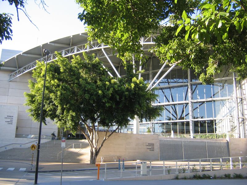
Entrance to Brisbane Convention & Exhibition Centre.
The Brisbane Convention & Exhibition Centre contains 24 meeting and event spaces including four exhibition halls with a combined area of 20,000m² and an auditorium capable of seating 8,000.[32] The venue has received 107 industry awards, making it the most awarded convention centre in Australia.[33] The centre has also been ranked among the top three convention centres world-wide by the Association Internationale des Palais de Congres (AIPC).[33]
Queensland Maritime Museum[]
The Queensland Maritime Museum is located next to the Goodwill Bridge at the southern end of the South Bank Parklands. It houses a two level exhibition building, a library, a dry dock, a lighthouse and several retired vessels.
Queensland Cultural Centre[]


Exterior of the Queensland Gallery of Modern Art.
The Queensland Cultural Centre consists of:
- The Queensland Performing Arts Centre,
- The Queensland Museum and Science Centre,
- The Queensland Art Gallery,
- The Queensland Gallery of Modern Art,
- The State Library of Queensland
Griffith University[]
The South Bank campus of Griffith University includes the Queensland Conservatorium and the Queensland College of Art and the Griffith Film School.
Southbank Institute of Technology[]
The Southbank Institute of Technology spreads over several blocks between the railway line and Merivale Street.
Business[]
Mater Health Services provides a wide range of public and private medical services in the area to the south of the suburb around Mater Hill and close to its border with Woolloongabba.
A number of major corporations have recently established offices in new buildings along Grey Street and Melbourne Street.
See also[]
References[]
- ^ a b c d Australian Bureau of Statistics (31 October 2012). "South Brisbane (Brisbane City) (State Suburb)". 2011 Census QuickStats. http://www.censusdata.abs.gov.au/census_services/getproduct/census/2011/quickstat/SSC31493?opendocument&navpos=220. Retrieved 26 February 2013.
- ^ a b "South Brisbane". Queensland Places. University of Queensland. http://queenslandplaces.com.au/south-brisbane. Retrieved 9 August 2011.
- ^ "PUBLIC GRAMMAR SCHOOL—A SUGGESTION.". The Brisbane Courier (National Library of Australia): p. 3. 28 October 1867. http://nla.gov.au/nla.news-article1288176. Retrieved 9 August 2011.
- ^ "Reflections of State High in the 1920s". History of Brisbane State High School. Brisbane State High School. http://www.brisbaneshs.eq.edu.au/index.php?q=reflections-state-high-1920s. Retrieved 9 August 2011.
- ^ (2 September 2011) "Introducing The Chambers". Connections 9 (2).
- ^ Ford, Garry (2008). "Trams, tramways and termini". Brisbane:Water, Power and Industry Paper No. 20: 62.
- ^ "A MEMORIAL PARK.". The Brisbane Courier (National Library of Australia): p. 7. 7 August 1923. http://nla.gov.au/nla.news-article20648477. Retrieved 6 April 2014.
- ^ "South Brisbane Memorial Park". Monument Australia. http://monumentaustralia.org.au/search/display/92517-south-brisbane-memorial-park. Retrieved 5 April 2014.
- ^ "Allgas Building (entry 15070)". Queensland Heritage Register. Queensland Heritage Council. https://heritage-register.ehp.qld.gov.au/placeDetail.html?siteId=15070. Retrieved 19 June 2013.
- ^ "Collins Place (entry 15071)". Queensland Heritage Register. Queensland Heritage Council. https://heritage-register.ehp.qld.gov.au/placeDetail.html?siteId=15071. Retrieved 19 June 2013.
- ^ "Expo 88 Nepalese Peace Pagoda (entry 19639)". Queensland Heritage Register. Queensland Heritage Council. https://heritage-register.ehp.qld.gov.au/placeDetail.html?siteId=19639. Retrieved 19 June 2013.
- ^ "Plough Inn (entry 15069)". Queensland Heritage Register. Queensland Heritage Council. https://heritage-register.ehp.qld.gov.au/placeDetail.html?siteId=15069. Retrieved 19 June 2013.
- ^ "Coorooman (entry 14999)". Queensland Heritage Register. Queensland Heritage Council. https://heritage-register.ehp.qld.gov.au/placeDetail.html?siteId=14999. Retrieved 19 June 2013.
- ^ "William Jolly Bridge (entry 16450)". Queensland Heritage Register. Queensland Heritage Council. https://heritage-register.ehp.qld.gov.au/placeDetail.html?siteId=16450. Retrieved 15 September 2013.
- ^ "South Brisbane Railway Station (entry 15082)". Queensland Heritage Register. Queensland Heritage Council. https://heritage-register.ehp.qld.gov.au/placeDetail.html?siteId=15082. Retrieved 2013-06-19.
- ^ "Queensland National Bank (former), South Brisbane Branch (entry 16870)". Queensland Heritage Register. Queensland Heritage Council. https://heritage-register.ehp.qld.gov.au/placeDetail.html?siteId=16870. Retrieved 19 June 2013.
- ^ "St. Mary's Catholic Church (Brisbane) (entry 17007)". Queensland Heritage Register. Queensland Heritage Council. https://heritage-register.ehp.qld.gov.au/placeDetail.html?siteId=17007. Retrieved 19 June 2013.
- ^ "Brisbane State High School, Block H (entry 15986)". Queensland Heritage Register. Queensland Heritage Council. https://heritage-register.ehp.qld.gov.au/placeDetail.html?siteId=15986. Retrieved 19 June 2013.
- ^ "Coronation Hotel (entry 15073)". Queensland Heritage Register. Queensland Heritage Council. https://heritage-register.ehp.qld.gov.au/placeDetail.html?siteId=15073. Retrieved 19 June 2013.
- ^ "Former Victoria Bridge Abutment (entry 15078)". Queensland Heritage Register. Queensland Heritage Council. https://heritage-register.ehp.qld.gov.au/placeDetail.html?siteId=15078. Retrieved 19 June 2013.
- ^ "South Brisbane Dry Dock (entry 15076)". Queensland Heritage Register. Queensland Heritage Council. https://heritage-register.ehp.qld.gov.au/placeDetail.html?siteId=15076. Retrieved 19 June 2013.
- ^ "South Brisbane Railway Easement (entry 15068)". Queensland Heritage Register. Queensland Heritage Council. https://heritage-register.ehp.qld.gov.au/placeDetail.html?siteId=15068. Retrieved 19 June 2013.
- ^ "South Brisbane Library (former) (entry 15077)". Queensland Heritage Register. Queensland Heritage Council. https://heritage-register.ehp.qld.gov.au/placeDetail.html?siteId=15077. Retrieved 19 June 2013.
- ^ "St Andrews Anglican Church (entry 15079)". Queensland Heritage Register. Queensland Heritage Council. https://heritage-register.ehp.qld.gov.au/placeDetail.html?siteId=15079. Retrieved 19 June 2013.
- ^ "Somerville House (entry 15080)". Queensland Heritage Register. Queensland Heritage Council. https://heritage-register.ehp.qld.gov.au/placeDetail.html?siteId=15080. Retrieved 19 June 2013.
- ^ "South Brisbane Municipal Chambers (former) (entry 15081)". Queensland Heritage Register. Queensland Heritage Council. https://heritage-register.ehp.qld.gov.au/placeDetail.html?siteId=15081. Retrieved 19 June 2013.
- ^ "Richard Randall's Studio (entry 15074)". Queensland Heritage Register. Queensland Heritage Council. https://heritage-register.ehp.qld.gov.au/placeDetail.html?siteId=15074. Retrieved 5 July 2013.
- ^ http://www.visitsouthbank.com.au/visitor_information
- ^ http://www.southbankcorporation.com.au/grey-street-boulevard
- ^ http://www.southbankcorporation.com.au/little-stanley-street
- ^ http://www.ourbrisbane.com/shopping/centres-and-precincts/grey-street-shopping
- ^ http://www.bcec.com.au/venue-and-services/rooms.aspx
- ^ a b http://www.bcec.com.au/index.aspx
External links[]
- South Brisbane section of Ourbrisbane.com via the Wayback Machine
- University of Queensland: Queensland Places: South Brisbane
| ||||||||||||||
| This page uses content from the English language Wikipedia. The original content was at South Brisbane, Queensland. The list of authors can be seen in the page history. As with this Familypedia wiki, the content of Wikipedia is available under the Creative Commons License. |