| Main | Births etc |
|---|
| The Entrance Central Coast, | |||||||||||||
 The Entrance | |||||||||||||

The Entrance | |||||||||||||
| Population: | 2632 [1] | ||||||||||||
| Postcode: | 2261 | ||||||||||||
| Area: | 1.4 km² (0.5 sq mi) | ||||||||||||
| Location: | |||||||||||||
| LGA: | Wyong Shire | ||||||||||||
| Parish: | Tuggerah | ||||||||||||
| State District: | The Entrance | ||||||||||||
| Federal Division: | Dobell | ||||||||||||
| |||||||||||||
The Entrance is a district centre and town of the Central Coast region of New South Wales, Australia. It is part of the Wyong Shire local government area. At the 2006 census, The Entrance had a population of 2,632 people.[1]
The town occupies an area of land that is bounded by water on three sides. The Entrance gains it name from the channel that runs along much of its northern border that is the entrance to The Tuggerah Lakes. The Entrance has been a popular holiday destination for people since the first guest house was established in 1885.[2]
The area is currently experiencing enormous growth as a result of small holiday cottages that dominated The Entrance for most of the 20th century being replaced by multi-storey units. The region's main tourist attractions are its beaches, lake and town centre. It is also suitably located for day trips to the Hunter Valley vineyards.
History[]
Settlements at the entrance[]
Although the area was previously inhabited by the Darkinjung people, the local Indigenous Australians, it is believed Europeans first discovered it in 1796. It was found by Governor of Tasmania, Colonel David Collins, who had arrived on the First Fleet during the search for an escaped convict woman, Mary Morgan, who was said to be living with the Aborigines to the North of the Hawkesbury River.[3]
The area now known as The Entrance was occupied by Henry Holden in 1828. He occupied 640 acres (259 ha) and was bounded by the Pacific Ocean on the eastern side, Tuggerah Lake on the northern and western sides and extended all the way to the current Toowoon Bay Road. Holden named the property Towoon. In 1835 the deeds were issued to John Edye Manning and he sold the land for £200 to Thomas Cade Battley who renamed the property Terilbah.[4]
In 1850, ownership was transferred to the Taylor Family and it was referred to as Tuggerah Beach. The land remained privately owned until about 1900 when it was divided up among the twelve children of Richard Brown Taylor and Norberta Maria Gertrude (née Watkins). The Taylors donated land to the Roman Catholic Church, The Church of England and The Entrance Public School.[5] Many streets in the area are named after them including Taylor Street, Richard Street, Norberta Street and Victoria Street.[6]
On 15 December 1910, Karagi Receiving Office was opened. Karagi, meaning the entrance, was the Aboriginal name for the point on the south bank of the channel at the Pacific Ocean, a name which has since been officially adopted. On 1 June 1911, Karagi Receiving Office was designated a Post Office. The name Karagi was not popular locally and on 15 November 1911, the English interpretation was adopted.[7]
Growth[]


Bayview guest house
In 1889 the railway line was completed from Sydney to Newcastle[8] and tourism began to develop in the area during the late 19th century following the construction of several guest houses. The first guest house in the area was built at The Entrance North by Mr and Mrs Walter Denniss in 1885 and was called Dunleith Guest House. Bayview Guest House was the first to be opened in the Entrance and was opened in 1900[9] by Mr and Mrs Dening (née Taylor). Pinehurst Guest House was another that was constructed in 1903 by Les Taylor and was by far the largest at that time. By 1912, members of the Taylor family were operating four guest houses at The Entrance.[10]
In March 1920, 200 parcels of land were auctioned after it had become clear that the land in the township needed to be subdivided. Each block of land averaged a selling price of £60 to £80, although some blocks closer to the water sold for as much as £200. Immediately holiday houses began to be built rapidly. It also resulted in a total of 15 guest houses operating soon after, including Lakeside built by Rene Johnson (née Taylor) that was the most exclusive. Although competition was fierce, the guesthouses had high occupancy rates in the booming times.[11] Bayview Avenue and Ozone Street are both named after guest houses that were located at The Entrance.[6]
Despite the growth, the area was still isolated and access was restricted to a wagon on the bush track from Gosford or by a ferry from Wyong. The area was popular among fishermen and prior to 1908 the majority of boats that travelled to The Entrance used Tuggerah Jetty, the remains of which, still exists on the shore of Tuggerah Lake between the entrances to Wyong River and Ourimbah Creek. When Wyong River was dredged in 1908, the boats would take their catch into Wyong.
Transport[]
The construction of Wyong Wharf allowed greater access to The Entrance and the demand for ferry transport boomed. Numerous operators took advantage of the demand and ferry's such as Wyong, Waiwera, Loongana and Maheno were making regular journeys across Tuggerah Lake. In 1922, the bush track to Wyong was opened as a road. By the end of the nineteen-twenties the ferry's were rendered obsolete by buses that could reach The Entrance quickly and cheaply.[12]

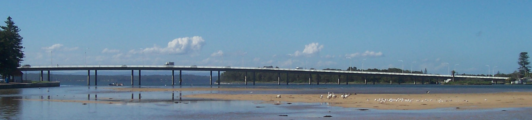
The Entrance Bridge links The Entrance with The Entrance North over The Entrance Channel as part of Wilfred Barrett Drive. It was originally a wooden single lane bridge with bypass bays that allowed traffic travelling in the opposite direction to pass.[13] It was opened in 1934. The original bridge was adequate until 1965 as it only served traffic travelling as far as The Entrance North.
By the end of 1965 the traffic flow over the old bridge at The Entrance increased to such an extent the structure was under constant repair.[3] Work began on the current two lane, concrete structure on 17 July 1967 after a successful tender by Transbridge Pty Ltd. The bridge was opened to traffic on 20 December 1968 and officially opened by the Premier of New South Wales, the Hon. Robert Askin on 18 April 1969.[14]
The Entrance is serviced by Red Bus Services, and the town is the major terminus, with several routes terminating and beginning in Torrens Avenue. Generally, Red Bus Services run every 30 to 60 minutes from 5am to 12am.[15]
Culture[]


Pelican feeding at The Entrance
The Entrance Cinema is another well-known icon. It is located on the corner of The Entrance Road and Bayview Mall. The cinema was opened as The Prince Edward Theatre in 1934 and was immediately popular due to the fire that burnt the other cinema in The Entrance, the Wintergarden Theatre in the same year. The Prince Edward Theatre closed in 1977 but was reopened in 1981 when it was purchased and converted into a smaller cinema. A second screen was added in 1988.[16] The cinema achieved notoriety in 2006 when it refused to screen the film, The Da Vinci Code as it was contrary to the owner's beliefs.[17]
In 1999, The Entrance waterfront was named 'The Pelican Capital of Australia' by Wyong Council to coincide with the opening of a pelican feeding platform as part of the waterfront redevelopment. The daily practice attracts 20,000 visitors annually. The Entrance is the perfect place for fishing. There are many species of fish that can be found in the area such as whiting, flathead, bream, and blackfish.[18]
Notable People[]
- Craig McLachlan - singer & actor, attended The Entrance Public School
- Natalie Imbruglia - singer & actress, attended Our Lady of the Rosary School, The Entrance
Commercial area[]
The Entrance town centre is located predominately along The Entrance Road, extending from Dening Street (named after the original owners of Bayview Guest House.[19]) to The Entrance Bridge.[6] Lakeside Shopping Centre (previously called Lakeside Plaza) containing a Coles supermarket and the post office, is located on the corner of The Entrance Road and Dening Street. The main street of the town (The Entrance Road) has approximately 200 shops, banks and services. Most stores are independent retailers, with only a small number of chain stores in the town. RMS, legal, medical, the library, and political offices are also located within the town. Medicare is co-located with Centrelink in Torrens Avenue. At the northern end of the main street the stores focus on the needs of tourists with fashion, cafes, and restaurants. Carparks for ca. 2000 cars are located throughout the town including Lakeside Shopping Centre, Theatre Lane, Ocean Parade, and Coral Street. The Entrance has two pubs located on The Entrance Road, these being "The Lakes" and "The Entrance". Wyong Shire Council has an office in the town.
Mardi Gras[]
To celebrate the start of the summer tourist season, on the first full weekend in December, The Entrance holds its annual Mardi Gras festival. The first Mardi Gras was held in 1950. Mardi Gras is the major event of the town and district for the year. The festival is named Mardi Gras after the spirit of the carnevals and Mardi Gras of Europe. The event contains a number of events including fun runs, concerts, fire works and displays. The highlight is the parade. This contains numerous floats from local organisations.
References[]
- ^ a b Australian Bureau of Statistics (25 October 2007). "The Entrance (State Suburb)". 2006 Census QuickStats. http://www.censusdata.abs.gov.au/ABSNavigation/prenav/LocationSearch?collection=Census&period=2006&areacode=SSC13371&producttype=QuickStats&breadcrumb=PL&action=401. Retrieved 17 January 2010.
- ^ "the-entrance-waldorf.com.au". Waldorf Apartment Hotel: The Entrance. http://www.the-entrance-waldorf.com.au/theentrance.html. Retrieved 2006-09-11.
- ^ a b "http://theentrance.org.au". Who Found Tuggerah Lake?. http://theentrance.org.au/discover/history. Retrieved 2006-07-18. Cite error: Invalid
<ref>tag; name "tetcm" defined multiple times with different content - ^ Pratt, Eileen (1978) Place Names of the Central Coast. Brisbane Water Historical Society and The Entrance and District Society. p49
- ^ "http://theentrance.org.au/". The Taylors Come To Town. http://theentrance.org.au/discover/history. Retrieved 2006-07-25.
- ^ a b c "http://theentrance.org.au/". Sign Posts To History. http://theentrance.org.au/discover/history. Retrieved 22 August 2006. Cite error: Invalid
<ref>tag; name "tetcmspth" defined multiple times with different content Cite error: Invalid<ref>tag; name "tetcmspth" defined multiple times with different content - ^ "The Entrance". Geographical Names Register (GNR) of NSW. Geographical Names Board of New South Wales. http://www.gnb.nsw.gov.au/place_naming/placename_search/extract?id=TRQlWytLJP. Retrieved 4 August 2013.
- ^ "ahc.gov.au". Australian Heritage Council - Australia's Transport and Communications 1788-1970 (Chapter 5: The Railway Age, 1874-1970). http://www.ahc.gov.au/publications/linking-nation/chapter-5.html#new. Retrieved 4 October 2006.
- ^ Stinson, Edward. A Pictorial History of the Wyong Shire: Volume 1 1979. Wyong Shire Council. ISBN 0-9595599-0-6. Page 142.
- ^ "http://theentrance.org.au/". Tourism. http://theentrance.org.au/discover/history. Retrieved 2006-08-21.
- ^ "http://theentrance.org.au/". Holiday Cottages. http://theentrance.org.au/discover/history. Retrieved 2006-08-21.
- ^ Stinson, Edward. A Pictorial History of the Wyong Shire: Volume 1 1979. Wyong Shire Council. ISBN 0-9595599-0-6. Page 29.
- ^ "wyong.nsw.gov.au". Historical Sites. http://www.wyong.nsw.gov.au/wyongshire/historical_sites.html. Retrieved 2006-08-22.
- ^ Pry, Kathryn. Fenton, Joan. History of Wyong Shire: 1947-1997 1997. Wyong Shire Council. ISBN 0-9587443-0-0. Page 113-114.
- ^ "redbus.com.au". Bus Route Index. Archived from the original on 2006-08-21. http://web.archive.org/web/20060821185814/http://redbus.com.au/busrouteindex.htm. Retrieved 2006-09-12.
- ^ Pry, Kathryn. Fenton, Joan. History of Wyong Shire: 1947-1997 1997. Wyong Shire Council. ISBN 0-9587443-0-0. Page 221.
- ^ "abc.net.au". Da Vinci Code Banned Already. http://www.abc.net.au/news/2006-05-20/da-vinci-code-banned-in-nsw-town/1759078. Retrieved 2006-07-04.
- ^ Callaghan, Paul (2 November 2006). "Why these tourism stars deserve tough love". The Central Coast Sun Weekly (Newcastle Newspapers): pp. 1–2.
- ^ "http://theentrance.org.au/". Shopping. http://theentrance.org.au/. Retrieved 2006-09-12.
Further reading[]
- Edward Stinson (September 1980). A Pictorial History of the Wyong Shire: Volume 2. Wyong Shire. ISBN 0-9595599-1-4.
- Edward Stinson (1994). A Pictorial History of the Wyong Shire: Volume 3 (second edition). Wyong Shire. ISBN 0-9595599-3-0.
- Edward Stinson (May 1983). A Pictorial History of the Wyong Shire: Volume 4. Wyong Shire. ISBN 0-9595599-4-9.
- Edward Stinson (October 1984). A Pictorial History of the Wyong Shire: Volume 5. Wyong Shire. ISBN 0-9595599-5-7.
- Edward Stinson (April 1988). A Pictorial History of the Wyong Shire: Volume 6. Wyong Shire. ISBN 0-9599520-2-0.
| |||||||||||||||||
| This page uses content from the English language Wikipedia. The original content was at The Entrance, New South Wales. The list of authors can be seen in the page history. As with this Familypedia wiki, the content of Wikipedia is available under the Creative Commons License. |