| ||||||||||||||
| Tioga County, Pennsylvania | |
 Tioga County Courthouse
| |
 Location in the state of Pennsylvania | |
 Pennsylvania's location in the U.S. | |
| Founded | October 13, 1812 |
|---|---|
| Named for | Tioga River |
| Seat | Wellsboro |
| Largest borough | Mansfield |
| Area - Total - Land - Water |
1,137 sq mi (2,945 km²) 1,134 sq mi (2,937 km²) 3.2 sq mi (8 km²), 0.3% |
| Population - (2020) - Density |
41,045 37/sq mi (14/km²) |
| Congressional district | 12th |
| Time zone | Eastern: UTC-5/-4 |
| Website | www.tiogacountypa.us |
Tioga County is a county located on the central northern border of the U.S. state of Pennsylvania. As of the 2020 census, the population was 41,045.[1] Its county seat is Wellsboro.[2] The county was created on March 26, 1804, from part of Lycoming County[3] and later organized in 1812.[4] It is named for the Tioga River.
History[]
The county was originally settled by migrants of "Yankee" stock (migrants from New England and the western part of New York who were descended from the English Puritans of colonial New England). With the opening of a rough wagon road to the source of the Tioga River, New England settlers poured over the Allegheny Mountains. Tioga County resembled upstate New York more than it did eastern Pennsylvania, as its population primarily consisted of settlers from New England.[5] Developers and land speculators laid out roads, established post routes, erected public buildings, and invited people to move there. The original settlers were entirely of New England origins or were Yankees from upstate New York, whose families had recent ancestors in New England, with migration taking place in the aftermath of the Revolutionary War. Tioga County was largely culturally contiguous with New England culture, which was influential across the Northern Tier of the United States through its migrants.
In the late 19th and early 20th centuries, the county accepted more immigrants from Ireland, Germany and eastern Europe, who came to work in the coal mines. A number of them were Roman Catholic, introducing more diversity into the mixture of religions here.
Geography[]
According to the U.S. Census Bureau, the county has a total area of 1,137 square miles (2,940 km2), of which 1,134 square miles (2,940 km2) is land and 3.2 square miles (8.3 km2) (0.3%) is water.[6] It is the fourth-largest county in Pennsylvania by land area and fifth-largest by total area. It has a warm-summer humid continental climate (Dfb) and average monthly temperatures in Wellsboro range from 22.8 °F in January to 68.2 °F in July. [1]
Adjacent counties[]
- Steuben County, New York (north)
- Chemung County, New York (northeast)
- Bradford County (east)
- Lycoming County (south)
- Potter County (west)
Demographics[]
| Historical populations | |||
|---|---|---|---|
| Census | Pop. | %± | |
| 1810 | 1,687 | ||
| 1820 | 4,021 | 138.4% | |
| 1830 | 8,978 | 123.3% | |
| 1840 | 15,498 | 72.6% | |
| 1850 | 23,987 | 54.8% | |
| 1860 | 31,044 | 29.4% | |
| 1870 | 35,097 | 13.1% | |
| 1880 | 45,814 | 30.5% | |
| 1890 | 52,313 | 14.2% | |
| 1900 | 49,086 | −6.2% | |
| 1910 | 42,829 | −12.7% | |
| 1920 | 37,118 | −13.3% | |
| 1930 | 31,871 | −14.1% | |
| 1940 | 35,004 | 9.8% | |
| 1950 | 35,474 | 1.3% | |
| 1960 | 36,614 | 3.2% | |
| 1970 | 39,691 | 8.4% | |
| 1980 | 40,973 | 3.2% | |
| 1990 | 41,126 | 0.4% | |
| 2000 | 41,372 | 0.6% | |
| 2010 | 41,981 | 1.5% | |
| U.S. Decennial Census[7] 1790–1960[8] 1900–1990[9] 1990–2000[10] 2010–2020[1] | |||
As of the census[11] of 2000, there were 41,373 people, 15,925 households, and 11,195 families residing in the county. The population density was 36 people per square mile (14/km2). There were 19,893 housing units at an average density of 18 per square mile (7/km2). The racial makeup of the county was 98.11% White, 0.60% Black or African American, 0.23% Native American, 0.30% Asian, 0.01% Pacific Islander, 0.14% from other races, and 0.61% from two or more races. 0.52% of the population were Hispanic or Latino of any race. Residents of Tioga County were of 31.9% English, 23.1% German, 10.1% Irish, 6.0% Polish and 5.3% Italian ancestry.
There were 15,925 households, out of which 30.40% had children under the age of 18 living with them, 57.80% were married couples living together, 8.60% had a female householder with no husband present, and 29.70% were non-families. 24.40% of all households were made up of individuals, and 11.30% had someone living alone who was 65 years of age or older. The average household size was 2.48 and the average family size was 2.93.
In the county, the population was spread out, with 23.70% under the age of 18, 10.60% from 18 to 24, 25.40% from 25 to 44, 24.20% from 45 to 64, and 16.00% who were 65 years of age or older. The median age was 38 years. For every 100 females there were 95.90 males. For every 100 females age 18 and over, there were 92.80 males.
Politics and government[]
| Year | Republican | Democratic | Third party | |||
|---|---|---|---|---|---|---|
| No. | % | No. | % | No. | % | |
| 2020 | 15,742 | 74.51% | 4,955 | 23.45% | 429 | 2.03% |
| 2016 | 13,614 | 73.56% | 3,901 | 21.08% | 992 | 5.36% |
| 2012 | 11,342 | 66.35% | 5,357 | 31.34% | 395 | 2.31% |
| 2008 | 11,326 | 62.48% | 6,390 | 35.25% | 410 | 2.26% |
| 2004 | 12,019 | 68.40% | 5,437 | 30.94% | 115 | 0.65% |
| 2000 | 9,635 | 65.22% | 4,617 | 31.26% | 520 | 3.52% |
| 1996 | 7,382 | 51.18% | 4,961 | 34.39% | 2,082 | 14.43% |
| 1992 | 7,823 | 47.29% | 4,868 | 29.43% | 3,852 | 23.28% |
| 1988 | 9,471 | 66.00% | 4,807 | 33.50% | 72 | 0.50% |
| 1984 | 10,532 | 71.92% | 4,060 | 27.72% | 52 | 0.36% |
| 1980 | 8,770 | 63.33% | 4,273 | 30.85% | 806 | 5.82% |
| 1976 | 8,417 | 58.43% | 5,795 | 40.23% | 193 | 1.34% |
| 1972 | 10,028 | 72.05% | 3,733 | 26.82% | 157 | 1.13% |
| 1968 | 9,298 | 67.07% | 3,488 | 25.16% | 1,077 | 7.77% |
| 1964 | 7,064 | 48.73% | 7,415 | 51.16% | 16 | 0.11% |
| 1960 | 11,082 | 73.04% | 4,076 | 26.86% | 15 | 0.10% |
| 1956 | 10,827 | 76.72% | 3,280 | 23.24% | 6 | 0.04% |
| 1952 | 11,203 | 78.65% | 3,006 | 21.10% | 35 | 0.25% |
| 1948 | 10,016 | 77.03% | 2,986 | 22.97% | 0 | 0.00% |
| 1944 | 10,381 | 75.73% | 3,248 | 23.69% | 79 | 0.58% |
| 1940 | 11,645 | 72.23% | 4,434 | 27.50% | 43 | 0.27% |
| 1936 | 12,567 | 69.40% | 5,442 | 30.05% | 99 | 0.55% |
| 1932 | 9,583 | 75.00% | 3,004 | 23.51% | 191 | 1.49% |
| 1928 | 11,774 | 87.23% | 1,688 | 12.51% | 36 | 0.27% |
| 1924 | 8,452 | 81.22% | 1,271 | 12.21% | 683 | 6.56% |
| 1920 | 9,718 | 83.28% | 1,258 | 10.78% | 693 | 5.94% |
| 1916 | 5,347 | 66.41% | 2,294 | 28.49% | 411 | 5.10% |
| 1912 | 1,895 | 22.40% | 1,901 | 22.48% | 4,662 | 55.12% |
| 1908 | 6,947 | 71.28% | 2,321 | 23.81% | 478 | 4.90% |
| 1904 | 7,410 | 79.32% | 1,541 | 16.50% | 391 | 4.19% |
| 1900 | 7,458 | 71.02% | 2,638 | 25.12% | 406 | 3.87% |
| 1896 | 7,922 | 71.42% | 2,828 | 25.50% | 342 | 3.08% |
| 1892 | 6,706 | 64.77% | 2,921 | 28.21% | 726 | 7.01% |
| 1888 | 7,808 | 69.23% | 2,972 | 26.35% | 499 | 4.42% |
| 1884 | 6,714 | 65.12% | 2,681 | 26.00% | 915 | 8.87% |
| 1880 | 6,018 | 60.17% | 2,815 | 28.14% | 1,169 | 11.69% |
Tioga County is one of the most heavily Republican represented counties in Pennsylvania. This has a long history as Abraham Lincoln reportedly received 78.57% of the county's vote in the 1860 Presidential election.[13] Since Abraham Lincoln the county has voted for the non-Republican presidential candidate only two times. The first was Theodore Roosevelt's 1912 run as a Progressive and the second was Lyndon B. Johnson's landslide in 1964.[14] In 2004, George W. Bush received 12,019 votes (68%) to 5,437 votes (31%) for John Kerry. In 2008 John McCain received 62.7% of the vote.[15] In 2006, Rick Santorum and Lynn Swann both had significant victories in Tioga County despite their defeats statewide. The last two sitting Board of Commissioners have been all Republican candidates, and Tioga County is the only county in Pennsylvania with all three sitting commissioners being from a single party. This was due to the success of write in campaigns conducted by Roger Bunn in 2011 and Mark Hamilton in 2015.
Elected officials[]
United States senator[]
- Robert "Bob" P. Casey, Jr (Democrat)
- Patrick "Pat" J. Toomey (Republican)
United States Congress[]
- Fred Keller (Republican) – 12th Pennsylvania Congressional District (Includes all of Tioga County).
Pennsylvania state senator[]
- Cris Dush – 25th District, Pennsylvania State Senate
Pennsylvania state representative[]
- Clint Owlett (Republican) – 68th District, Pennsylvania House of Representatives
County commissioners[]
- Roger C. Bunn, chair (Republican)
- Erick J. Coolidge (Republican)
- Mark L. Hamilton, vice-chair (Republican)
Court of Common Pleas judge, 4th Judicial District of Pennsylvania[]
- George W. Wheeler (Republican/Democrat)
Magisterial district judge[]
- James E. Carlson – District Court 04-3-02 (Mansfield)
- Robert Repard – District Court 04-3-02 (Wellsboro)
- James Edgecomb – District Court 04-3-01 (Elkland)
District attorney[]
- Krista Deats (Republican)
Register of wills / recorder of deeds[]
- Jane E. Wetherbee (Republican)
Prothonotary / clerk of courts[]
- Marie Seymour (Republican)
County treasurer[]
- Kera Hackett (Republican)
Sheriff[]
- Frank Levindoski (Republican)
Coroner[]
- James L. Wilson (Republican)
Auditors[]
- Rebecca B. Briggs (Republican)
- Elizabeth T. Craig (Republican)
- Amy Kane Perry (Republican)
Education[]

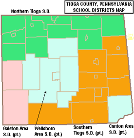
Map of Tioga County, Pennsylvania Public School Districts
Colleges and universities[]
- Mansfield University in Mansfield is a member of the Pennsylvania State System of Higher Education.
Public school districts[]
- Canton Area School District (also in Bradford County and Lycoming County)
- Galeton Area School District (also in Potter County)
- Northern Tioga School District
- Southern Tioga School District (also in Lycoming County)
- Wellsboro Area School District
Private schools[]
As reported by EdNA, Pennsylvania Department of Education, June 2010.
- Covington Community DCC, Covington
- Irvin Comstock Seventh-Day Adventist School, Wellsboro
- Laurel Youth Services, Blossburg
- Lauries Bright Beginnings CCC, Millerton
- Mansfield Area Nursery School, Mansfield
- Maranatha Mission Learning Community Branch 20, Trout Run
- New Covenant Academy, Mansfield
- Presbyterian Child Development Center, Wellsboro
- Stony Fork Mennonite School, Wellsboro
- Trinity Lutheran School, Wellsboro
- Toddler University, Blossburg
- Toddler University, Trinity
- Wellsboro Montessori Children's Center, Wellsboro
- Wesley Academy, Elkland
Public libraries[]
- Blossburg Memorial Library
- Elkland Area Community Library
- Green Free Library – Wellsboro
- Knoxville Public Library
- Mansfield Free Public Library
- Potter-Tioga County Lib System
- Westfield Public Library
Transportation[]
Public transportation is provided by BeST Transit.
Major highways[]
 Future I-99
- US 6
- US 15
- US 15 Bus.
- [[Template:Infobox road/PA/link PA|PA 14]]
- [[Template:Infobox road/PA/link PA|PA 49]]
- [[Template:Infobox road/PA/link PA|PA 249]]
- [[Template:Infobox road/PA/link PA|PA 287]]
- [[Template:Infobox road/PA/link PA|PA 328]]
- [[Template:Infobox road/PA/link PA|PA 349]]
- [[Template:Infobox road/PA/link PA|PA 362]]
- [[Template:Infobox road/PA/link PA|PA 414]]
- [[Template:Infobox road/PA/link PA|PA 549]]
- [[Template:Infobox road/PA/link PA|PA 660]]
Recreation[]
There are three Pennsylvania state parks in Tioga County.
- Hills Creek State Park is several miles north of U.S. Route 6 between Wellsboro and Mansfield in Charleston Township.
- Colton Point State Park and Leonard Harrison State Park are both part of the Pennsylvania Grand Canyon that is carved by Pine Creek.
Communities[]

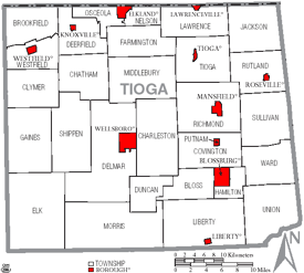
Map of Tioga County, Pennsylvania with Municipal Labels showing Boroughs (red) and Townships (white).
Under Pennsylvania law, there are four types of incorporated municipalities: cities, boroughs, townships, and, in at most two cases, towns. The following boroughs and townships are located in Tioga County:
Boroughs[]
- Blossburg
- Elkland
- Knoxville
- Lawrenceville
- Liberty
- Mansfield
- Roseville
- Tioga
- Wellsboro (county seat)
- Westfield
Townships[]
- Bloss
- Brookfield
- Charleston
- Chatham
- Clymer
- Covington
- Deerfield
- Delmar
- Duncan
- Elk
- Farmington
- Gaines
- Hamilton
- Jackson
- Lawrence
- Liberty
- Middlebury
- Morris
- Nelson
- Osceola
- Putnam
- Richmond
- Rutland
- Shippen
- Sullivan
- Tioga
- Union
- Ward
- Westfield
Census-designated places[]
Census-designated places are geographical areas designated by the U.S. Census Bureau for the purposes of compiling demographic data. They are not actual jurisdictions under Pennsylvania law. Other unincorporated communities, such as villages, may be listed here as well.
- Arnot
- Millerton
Ghost town[]
- Fall Brook
Population ranking[]
The population ranking of the following table is based on the 2010 census of Tioga County.[16]
† county seat
| Rank | City/Town/etc. | Municipal type | Population (2010 Census) |
|---|---|---|---|
| 1 | Mansfield | Borough | 3,625 |
| 2 | † Wellsboro | Borough | 3,263 |
| 3 | Elkland | Borough | 1,821 |
| 4 | Blossburg | Borough | 1,538 |
| 5 | Westfield | Borough | 1,064 |
| 6 | Tioga | Borough | 666 |
| 7 | Knoxville | Borough | 629 |
| 8 | Lawrenceville | Borough | 581 |
| 9 | Arnot | CDP | 332 |
| 10 | Millerton | CDP | 316 |
| 11 | Liberty | Borough | 249 |
| 12 | Roseville | Borough | 189 |
See also[]
- National Register of Historic Places listings in Tioga County, Pennsylvania
References[]
- ^ a b "State & County QuickFacts". United States Census Bureau. http://quickfacts.census.gov/qfd/states/42/42117.html.
- ^ "Find a County". National Association of Counties. http://www.naco.org/Counties/Pages/FindACounty.aspx.
- ^ An outline history of Tioga and Bradford counties in Pennsylvania, Chemung, Steuben, Tioga, Tompkins and Schuyler in New York: by townships, villages, boro's and cities, John L. Sexton. The Gazette Company, 1885, p3. 1885. p. 3. https://archive.org/details/bub_gb_kWlCAAAAYAAJ. "tioga county, pa. sexton."
- ^ "Pennsylvania: Individual County Chronologies". The Newberry Library. 2008. http://publications.newberry.org/ahcbp/documents/PA_Individual_County_Chronologies.htm.
- ^ The Expansion of New England: The Spread of New England Settlement and Institutions to the Mississippi River, 1620–1865, pp. 151-152
- ^ "2010 Census Gazetteer Files". United States Census Bureau. August 22, 2012. http://www2.census.gov/geo/docs/maps-data/data/gazetteer/counties_list_42.txt.
- ^ "U.S. Decennial Census". United States Census Bureau. https://www.census.gov/programs-surveys/decennial-census.html.
- ^ "Historical Census Browser". University of Virginia Library. http://mapserver.lib.virginia.edu.
- ^ Forstall, Richard L., ed (March 24, 1995). "Population of Counties by Decennial Census: 1900 to 1990". United States Census Bureau. https://www.census.gov/population/cencounts/pa190090.txt.
- ^ "Census 2000 PHC-T-4. Ranking Tables for Counties: 1990 and 2000". United States Census Bureau. April 2, 2001. https://www.census.gov/population/www/cen2000/briefs/phc-t4/tables/tab02.pdf.
- ^ "U.S. Census website". United States Census Bureau. https://www.census.gov.
- ^ Leip, David. "Dave Leip's Atlas of U.S. Presidential Elections". http://uselectionatlas.org/RESULTS.
- ^ "David Leip Presidential Election Atlas for 1860". http://uselectionatlas.org/RESULTS/stats.php?year=1860&f=1&off=0&elect=0.
- ^ "Presidential election of 1912 – Map by counties". http://geoelections.free.fr/USA/elec_comtes/1912.htm.
- ^ "President Map – Election Results 2008 – The New York Times". http://elections.nytimes.com/2008/results/president/map.html?scp=1&sq=%22election+map&st=cse.
- ^ Promotions, Center for New Media and. "US Census Bureau 2010 Census". https://www.census.gov/programs-surveys/decennial-census/decade.2010.html.
External links[]
- Tioga County, Pennsylvania
- Map 562 *Augmented by Williams, J. H., Taylor, L. E., and Low, D. J. (1993), Surficial geologic map of major glaciated valleys of Bradford, Tioga, and Potter Counties, Pennsylvania, showing locations of wells, test holes, and data-collection sites, Pennsylvania Geological Survey, 4th ser., Water Resource Report 68.
| |||||||||||||||||

|
| This page uses content from the English language Wikipedia. The original content was at Tioga County, Pennsylvania. The list of authors can be seen in the page history. As with this Familypedia wiki, the content of Wikipedia is available under the Creative Commons License. |