| Main | Births etc |
|---|
| Turzovka | |
|---|---|
| — Town — | |
 |
|

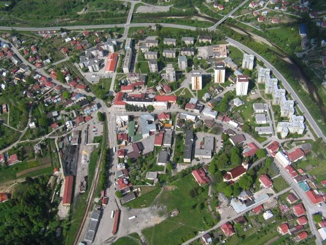
Turzovka |
|

Turzovka |
|
| Coordinates: | |
| Country | |
| Region | Žilina |
| District | Čadca |
| Established | 1598 |
| Government | |
| • Mayor | Miroslav Rejda |
| Area | |
| • Total | 34.98 km2 (13.51 sq mi) |
| Elevation | 522 m (1,713 ft) |
| Population (2011-12-31) | |
| • Total | 7,621 |
| • Density | 217.87/km2 (564.3/sq mi) |
| Time zone | CET (UTC+1) |
| • Summer (DST) | CEST (UTC+2) |
| Postal code | 023 54 |
| Area code | +421-41 |
| Vehicle registration | CA |
Turzovka (Hungarian: Turzófalva, Polish: Turzówka) is a town in the Čadca District, Žilina Region in north-western Slovakia.
History[]
The present-day town was established in 1598 by a palatine of the Thurzo family. It gained town status in 1968.
Geography[]
Turzovka lies at an altitude of 471 metres (1,545 ft) above sea level and covers an area of 34.911 square kilometres (13.5 sq mi).[1] It lies in the Kysuca river valley, surrounded by the mountain ranges of Beskydy and Javorníky.
Demographics[]
According to the 2001 census, the town had 7,854 inhabitants. 96.47% of inhabitants were Slovaks, 0.98% Czech and 0.36% Gypsies.[1] The religious make-up was 94.37% Roman Catholics, 1.86% people with no religious affiliation, and 0.27% Lutherans.[1]
References[]
- ^ a b c "Municipal Statistics". Statistical Office of the Slovak republic. Archived from the original on 2008-01-11. http://web.archive.org/web/20080111223415/http://www.statistics.sk/mosmis/eng/run.html. Retrieved 2008-01-30.
External links[]
| |||||||