| ||||||||||||||
| Van Buren County, Tennessee | |
 Van Buren County Courthouse in Spencer
| |
Location in the state of Tennessee | |
 Tennessee's location in the U.S. | |
| Founded | January 3, 1840 |
|---|---|
| Named for | Martin Van Buren[1] |
| Seat | Spencer |
| Largest town | Spencer |
| Area - Total - Land - Water |
275 sq mi (712 km²) 273 sq mi (707 km²) 1.1 sq mi (3 km²), 0.4% |
| Population - (2020) - Density |
6,168 20/sq mi (8/km²) |
| Congressional districts | 4th, 6th |
| Time zone | Central: UTC-6/-5 |
| Website | https://vanburencountytn.com/ |
Van Buren County is a county located in the U.S. state of Tennessee. As of the 2020 census, the population was 6,168, making it the second-least populous county in Tennessee.[2] Its county seat is Spencer.[3]
History[]
Van Buren County was formed in 1840 from parts of White, Warren and Bledsoe counties. It was named for President Martin Van Buren.[1] The county seat, Spencer, was home to Burritt College, one of the South's first coeducational colleges, during the 19th and early 20th centuries.[1]
Geography[]
According to the U.S. Census Bureau, the county has a total area of 275 square miles (710 km2), of which 273 square miles (710 km2) is land and 1.1 square miles (2.8 km2) (0.4%) is water.[4] The county straddles the western edge of the Cumberland Plateau, with the eastern portion of the county lying atop the Plateau, and the western portion lying on the lower Highland Rim.[1] The Caney Fork, the county's primary drainage, forms part of its northern border with White County. The Rocky River, a tributary of the Caney Fork, forms part of the county's western border with Warren. Cane Creek, another tributary of the Caney Fork, drains the Fall Creek Falls area.


Fall Creek Falls


Hills near Spencer
Big Bone Cave is located in the northwest corner of Van Buren County. It is one of the best-known and most historic caverns in Tennessee. It was mined by prehistoric Indians for gypsum and salts and was the site of the largest saltpeter mine in Tennessee during the War of 1812 and again during the American Civil War. The cave is named for the discovery of the skeleton of a Giant Ground Sloth (Megalonyx jeffersoni) by saltpeter miners in 1811. Many of the wooden saltpeter mining artifacts in the cave remain in a remarkable state of preservation, due to the extreme dryness of the cave.[5][6]
Van Buren County boasts over 850 documented caves (over 3.09 caves per square mile), making it one of the most cave dense regions in the world (nearby White County has over 3.17 caves per square mile).[7]
Adjacent counties[]
- White County (north)
- Cumberland County (northeast)
- Bledsoe County (east)
- Sequatchie County (south)
- Warren County (west)
State protected areas[]
- Big Bone Cave State Natural Area
- Bledsoe State Forest (part)
- Fall Creek Falls State Natural Area (part)
- Fall Creek Falls State Resort Park (part)
Demographics[]
| Historical populations | |||
|---|---|---|---|
| Census | Pop. | %± | |
| 1850 | 2,674 | ||
| 1860 | 2,581 | −3.5% | |
| 1870 | 2,725 | 5.6% | |
| 1880 | 2,933 | 7.6% | |
| 1890 | 2,863 | −2.4% | |
| 1900 | 3,126 | 9.2% | |
| 1910 | 2,784 | −10.9% | |
| 1920 | 2,624 | −5.7% | |
| 1930 | 3,516 | 34.0% | |
| 1940 | 4,090 | 16.3% | |
| 1950 | 3,985 | −2.6% | |
| 1960 | 3,671 | −7.9% | |
| 1970 | 3,758 | 2.4% | |
| 1980 | 4,728 | 25.8% | |
| 1990 | 4,846 | 2.5% | |
| 2000 | 5,508 | 13.7% | |
| 2010 | 5,548 | 0.7% | |
| U.S. Decennial Census[8] 1790-1960[9] 1900-1990[10] 1990-2000[11] 2010-2020[12] 2020[2] | |||
 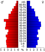 Age pyramid Van Buren County[13] |
2020 census[]
| Race | Number | Percentage |
|---|---|---|
| White (non-Hispanic) | 5,866 | 95.1% |
| Black or African American (non-Hispanic) | 20 | 0.32% |
| Native American | 7 | 0.11% |
| Asian | 10 | 0.16% |
| Pacific Islander | 1 | 0.02% |
| Other/Mixed | 181 | 2.93% |
| Hispanic or Latino | 83 | 1.35% |
As of the 2020 United States census, there were 6,168 people, 2,141 households, and 1,545 families residing in the county.
2010 census[]
As of the 2010 census,[15] there were 5,548 people and 2,096 households in the county. The population density was 20.3 people per square mile (8/km2). There were 2,673 housing units at an average density of 9.8 per square mile (3/km2). The racial makeup of the county was 97.5% White, 0.7% Black or African American, 0.3% Native American, 0.2% Asian, and 0.9% from two or more races. 0.9% of the population were Hispanic or Latino of any race.
There were 2,096 households, out of which 29.3% had children under the age of 18 living with them, 54.9% were married couples living together, 11.7% had a female householder with no husband present, and 28.0% were non-families. 24.3% of all households were made up of individuals, while 30.6% had someone living alone who was 65 years of age or older. The average household size was 2.43. 82.6% of occupied housing units were owner-occupied, meaning that 17.4% were renter-occupied.
In the county, the population was spread out, with 23.2% up to the age of 19, 8.8% from 20 to 29, 12.4% from 30 to 39, 13.4% from 40 to 49, 16.8% from 50 to 59, 14.7% from 60 to 69, and 10.7% who were 70 years of age or older. The median age was 44.5 years. Women make up 50.2% of the population.
The median income for a household in the county was $29,087. The per capita income for the county was $17,160. 24.6% of the population were below the poverty line.
Recreation[]
Van Buren County is home to a portion of Fall Creek Falls State Resort Park.
Communities[]
Town[]
- Spencer (county seat)
Unincorporated communities[]
- Bone Cave
- Cedar Grove
Education[]
Van Buren County Schools operates public schools.
Politics[]
For many decades, Van Buren county was a reliably Democratic county at the presidential level, voting for the Democratic candidate for president in all but two elections from 1880 to 2004. This trend has reversed dramatically in recent years, with Republican candidates winning the county in each of the past four elections. In 2020, Republican Donald Trump won the highest share of the vote for a Republican presidential candidate ever in Van Buren County, earning 80.2% of the vote.
| Year | Republican | Democratic | Third party | |||
|---|---|---|---|---|---|---|
| No. | % | No. | % | No. | % | |
| 2020 | 2,342 | 80.18% | 544 | 18.62% | 35 | 1.20% |
| 2016 | 1,820 | 75.24% | 539 | 22.28% | 60 | 2.48% |
| 2012 | 1,386 | 60.26% | 875 | 38.04% | 39 | 1.70% |
| 2008 | 1,294 | 58.66% | 849 | 38.49% | 63 | 2.86% |
| 2004 | 1,120 | 47.72% | 1,209 | 51.51% | 18 | 0.77% |
| 2000 | 845 | 39.65% | 1,255 | 58.89% | 31 | 1.45% |
| 1996 | 504 | 30.31% | 1,010 | 60.73% | 149 | 8.96% |
| 1992 | 555 | 26.68% | 1,329 | 63.89% | 196 | 9.42% |
| 1988 | 780 | 49.37% | 796 | 50.38% | 4 | 0.25% |
| 1984 | 718 | 46.78% | 810 | 52.77% | 7 | 0.46% |
| 1980 | 499 | 35.54% | 886 | 63.11% | 19 | 1.35% |
| 1976 | 346 | 23.99% | 1,085 | 75.24% | 11 | 0.76% |
| 1972 | 629 | 61.61% | 364 | 35.65% | 28 | 2.74% |
| 1968 | 327 | 29.30% | 282 | 25.27% | 507 | 45.43% |
| 1964 | 293 | 25.30% | 865 | 74.70% | 0 | 0.00% |
| 1960 | 401 | 40.30% | 577 | 57.99% | 17 | 1.71% |
| 1956 | 381 | 38.45% | 602 | 60.75% | 8 | 0.81% |
| 1952 | 393 | 36.12% | 674 | 61.95% | 21 | 1.93% |
| 1948 | 298 | 30.47% | 636 | 65.03% | 44 | 4.50% |
| 1944 | 291 | 35.49% | 526 | 64.15% | 3 | 0.37% |
| 1940 | 318 | 30.20% | 732 | 69.52% | 3 | 0.28% |
| 1936 | 251 | 26.67% | 690 | 73.33% | 0 | 0.00% |
| 1932 | 196 | 23.53% | 613 | 73.59% | 24 | 2.88% |
| 1928 | 257 | 49.71% | 260 | 50.29% | 0 | 0.00% |
| 1924 | 123 | 25.47% | 357 | 73.91% | 3 | 0.62% |
| 1920 | 223 | 38.32% | 351 | 60.31% | 8 | 1.37% |
| 1916 | 151 | 26.58% | 405 | 71.30% | 12 | 2.11% |
| 1912 | 106 | 27.53% | 225 | 58.44% | 54 | 14.03% |
| 1908 | 176 | 34.58% | 329 | 64.64% | 4 | 0.79% |
| 1904 | 160 | 31.25% | 352 | 68.75% | 0 | 0.00% |
| 1900 | 153 | 26.42% | 425 | 73.40% | 1 | 0.17% |
| 1896 | 140 | 24.43% | 419 | 73.12% | 14 | 2.44% |
| 1892 | 89 | 18.09% | 360 | 73.17% | 43 | 8.74% |
| 1888 | 103 | 18.76% | 423 | 77.05% | 23 | 4.19% |
| 1884 | 59 | 14.46% | 348 | 85.29% | 1 | 0.25% |
| 1880 | 60 | 17.60% | 281 | 82.40% | 0 | 0.00% |
See also[]
- National Register of Historic Places listings in Van Buren County, Tennessee
References[]
- ^ a b c d Margaret Binnicker, "Van Buren County," Tennessee Encyclopedia of History and Culture. Retrieved: 19 April 2013.
- ^ a b "2020 Census Data". https://data.census.gov/cedsci/profile?g=0500000US47175.
- ^ "Find a County". National Association of Counties. http://www.naco.org/Counties/Pages/FindACounty.aspx.
- ^ "2010 Census Gazetteer Files". United States Census Bureau. August 22, 2012. http://www2.census.gov/geo/docs/maps-data/data/gazetteer/counties_list_47.txt.
- ^ Thomas C. Barr, Jr., Caves of Tennessee, Tennessee Division of Geology, Bulletin 64, 1961.
- ^ Larry E. Matthews, Big Bone Cave, National Speleological Society, 220 pp, 2006. ISBN 978-1-879961-24-1
- ^ "Tennessee Cave Survey". http://www.subworks.com/tcs/.
- ^ "U.S. Decennial Census". United States Census Bureau. https://www.census.gov/programs-surveys/decennial-census.html.
- ^ "Historical Census Browser". University of Virginia Library. http://mapserver.lib.virginia.edu.
- ^ Forstall, Richard L., ed (March 27, 1995). "Population of Counties by Decennial Census: 1900 to 1990". United States Census Bureau. https://www.census.gov/population/cencounts/tn190090.txt.
- ^ "Census 2000 PHC-T-4. Ranking Tables for Counties: 1990 and 2000". United States Census Bureau. April 2, 2001. https://www.census.gov/population/www/cen2000/briefs/phc-t4/tables/tab02.pdf.
- ^ "State & County QuickFacts". United States Census Bureau. http://quickfacts.census.gov/qfd/states/47/47175.html.
- ^ Based on 2000 census data
- ^ "Explore Census Data". https://data.census.gov/cedsci/table?g=0500000US47175&tid=DECENNIALPL2020.P2.
- ^ "U.S. Census website". United States Census Bureau. https://www.census.gov.
- ^ Leip, David. "Dave Leip's Atlas of U.S. Presidential Elections". http://uselectionatlas.org/RESULTS.
External links[]
- UT Extension office
- Van Buren County Chamber of Commerce
- Van Buren County Schools
- TNGenWeb
- Van Buren County at Curlie

|
White County | Cumberland County |
| |
| Warren County | Bledsoe County | |||
 Van Buren County, Tennessee | ||||
| Sequatchie County |
Template:Van Buren County, Tennessee
|
| This page uses content from the English language Wikipedia. The original content was at Van Buren County, Tennessee. The list of authors can be seen in the page history. As with this Familypedia wiki, the content of Wikipedia is available under the Creative Commons License. |