| Main | Births etc |
|---|
| Vorarlberg | |||
|---|---|---|---|
| — State of Austria — | |||
|
|||
 |
|||
| Country | |||
| Capital | Bregenz | ||
| Government | |||
| • Governor | Markus Wallner (ÖVP) | ||
| Area | |||
| • Total | 2,601.12 km2 (1,004.30 sq mi) | ||
| Population | |||
| • Total | 370,800 | ||
| • Density | 140/km2 (370/sq mi) | ||
| Time zone | CET (UTC+1) | ||
| • Summer (DST) | CEST (UTC+2) | ||
| ISO 3166 code | AT-8 | ||
| NUTS Region | AT3 | ||
| Votes in Bundesrat | 3 (of 62) | ||
| Website | vorarlberg.at | ||


Vorarlberg is the westernmost federal-state (Land) of Austria. Although it is the second smallest in terms of area (Vienna is the smallest) and population (Burgenland is less populated), it borders three countries: Germany (Bavaria and Baden-Württemberg via Lake Constance), Switzerland (Graubünden and St. Gallen) and Liechtenstein. The only Austrian federal state that shares a border with Vorarlberg is Tyrol to the east.
The capital of Vorarlberg is Bregenz (28,000 inhabitants), although Dornbirn (45,000 inhabitants) and Feldkirch (30,000 inhabitants) are larger cities in terms of population. Vorarlberg is also distinct in that it is the only province in Austria that does not speak an Austro-Bavarian, but rather an Alemannic dialect; it therefore culturally has much more in common with its Alemannic-speaking neighbors Switzerland, Liechtenstein and Swabia than with Bavaria and the rest of Austria.
Geography[]
The main rivers in Vorarlberg are the Ill (running through the Montafon and Walgau valleys into the Rhine), the Rhine (forming the border to Switzerland), the Bregenzer Ach and the Dornbirner Ach. One of the shortest rivers is the Galina. Important lakes, apart from Lake Constance are Lüner Lake, Silvretta Lake, Vermunt Lake, Spuller Lake, the Kops Basin and Formarin Lake; the first four were created for the production of hydroelectric energy. However even before the dam for the power plant was built, Lüner Lake was the largest mountain lake in the Alps. Most of this hydroelectric energy is exported to Germany at peak times. At night energy from power plants in Germany is used to pump water back into some of the lakes.
As there are several notable mountain ranges in Vorarlberg, such as the Silvretta, the Rätikon, the Verwall and the Arlberg, there are many famous skiing regions (Arlberg, Montafon, Bregenzerwald) and ski resorts (Lech, Zürs, Schruns, Warth, Damüls, Brand and many more). Damüls is also famous as the municipality with the most annual snowfall worldwide (on average 9.30 meters). The highest mountain is Piz Buin, whose rocky peak of 3,312 meters is surrounded by glaciers. Vorarlberg is supposed to enjoy the greatest scenic diversity within limited confines in the entire Eastern Alps; it adjoins the Western Alps. The distance from Lake Constance and the plains of the Rhine valley across the medium altitude and high alpine zones to the glaciers of the Silvretta range is a mere 90 km.
Administrative divisions[]
Vorarlberg is divided into four large districts, from north to south: Bregenz, Dornbirn, Feldkirch and Bludenz. These districts appear on the automobile license plates in the form of abbreviations: B, DO, FK and BZ.
Economy[]
For several years, the Vorarlberg economy has been performing well above the Austrian average. While the overall Austrian GDP in 2004 rose by a "mere" 2.0% in real terms, Vorarlberg recorded an increase of 2.9%. This came as a surprise, particularly as the major trading partners in Germany and Italy did not fare well. Owing to this robust economic performance, Vorarlberg was able to boost its gross regional product in 2004 to 11.5 billion EUR according to the Economic Policy Department of the Vorarlberg Chamber of Trade. This translates into a nominal increase of 5.0% (cf Austria as a whole +4.0%). The regional product per inhabitant in Vorarlberg is 31,000 EUR, exceeding the Austrian national average by 8%. Vorarlberg and especially the Rhine Valley is one of the wealthiest areas of the world, with a very high standard of living. In addition to the flourishing textile, clothing, electronics, machinery and packing materials industries of the Rhine Valley, there is also a broad agricultural base, especially in the Bregenz Forest (Bregenzerwald), which is noted for its dairy products ("Bregenzerwälder Cheese Route") and tourism. The tourist industry employs a considerable number of Vorarlbergers. The greatest tourist attractions are the mountains and the numerous ski resorts, the largest (and most famous) of which are:
- the Bregenz Forest,
- the Arlberg region (including the high-class ski resorts Lech and Zürs),
- the Brandnertal, and
- the Montafon.
Famous skiers from these regions include Anita Wachter, Egon Zimmermann, Gerhard Nenning, Mario Reiter, Hubert Strolz, Hannes Schneider and the ski-jumper Toni Innauer.[1]
Demographics[]
The population of Vorarlberg is 372,500. The majority (86%) of residents are of Austrian-Germanic stock with a cultural connection with Switzerland and Liechtenstein to the west and Germany to the north. A sizable proportion of the population's ancestors came from the Swiss canton of Valais in migrations of "Walsers", including the Swiss French in the 19th century by invitation during the days of the Austro-Hungarian Empire.
Religion[]
78% of the population is Roman Catholic, which puts Vorarlberg in line with national Austrian average of (73.6%). The second largest religious denomination is Islam which has a share of 8.4%. 7,817 (or 2.2%) of Vorarlberg inhabitants are Protestant.
Language[]
Owing to their location isolated from the rest of Austria, most people in Vorarlberg speak a very distinct German dialect that other Austrians have difficulty understanding. It is one of the Alemannic dialects that are also spoken in Liechtenstein and the Lake Constance Alemannic area. Further Alemannic dialects are spoken in Switzerland as Swiss German, Baden-Württemberg and the Alsace region of France. The dialects in the rest of Austria form part of the Bavarian-Austrian language group. In fact many towns and even villages in Vorarlberg have their own distinct sub-dialects.
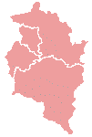
Districts of Vorarlberg. Clockwise from north: Bregenz, Bludenz, Feldkirch, Dornbirn
History[]
Before the Romans conquered Vorarlberg, there were two Celtic tribes settled in this area: the Raeti inhabiting the highlands, and the Vindelici dwelling in the lowlands, i.e. the Lake Constance region and the Rhine Valley. One of the important settlements of the Vindelici was Brigantion (today Bregenz), founded around 500 BC. It was conquered by the Romans in 15 BC.
Vorarlberg was once part of the Roman Empire in the Roman province of Raetia; it then fell under the rule of the Bavarians. Subsequently, the region was settled by the Bavarians and the Lombards and later fell under the rule of the Counts of Montfort until 1525, when the Habsburgs took control.[1]
The historically Germanic province, which was a gathering together of former bishoprics, was still ruled in part by a few semi-autonomous counts and surviving bishoprics until the start of World War I. Vorarlberg was a part of Further Austria, and parts of the area were ruled by the Counts Montfort of Vorarlberg.
Following World War I there was a desire by many in Vorarlberg to join Switzerland.[2] In a referendum held in Vorarlberg on 11 May 1919, over 80% of those voting supported a proposal for the state to join the Swiss Confederation. However this was prevented by the opposition of the Austrian government, the Allies, Swiss liberals, the Swiss-Italians and the Swiss-French.[3][1]
After the Second World War, between 1945 and 1955, Vorarlberg found itself occupied by French troops, along with most of the Tyrol province.
See also[]
- Principle Hope
Notes[]
- ^ a b c The Free Dictionary by Farlex: Voralberg
- ^ 1982 edition of Encyclopaedia Britannica, "History of Austria"
- ^ C2D - Centre d'études et de documentation sur la démocratie directe
External links[]
- Official website
- Internet Portal for Vorarlberg
- Vorarlberg tourism
- Landscape of Vorarlberg
- See all restaurants of Vorarlberg with pictures
- about the dialect in Vorarlberg- in German
| |||||
Template:Vorarlberg
| This page uses content from the English language Wikipedia. The original content was at Vorarlberg. The list of authors can be seen in the page history. As with this Familypedia wiki, the content of Wikipedia is available under the Creative Commons License. |