| Waynesville, North Carolina | |||
|---|---|---|---|
| — Town — | |||
| Overlooking the town of Waynesville | |||
|
|||
 |
|||
| Coordinates: Coordinates: | |||
| Country | United States | ||
| State | North Carolina | ||
| County | Haywood | ||
| Incorporated | 1871 | ||
| Government | |||
| • Mayor | Gavin A. Brown | ||
| Area | |||
| • Total | 7.8 sq mi (20.1 km2) | ||
| • Land | 7.8 sq mi (20.1 km2) | ||
| • Water | 0 sq mi (0 km2) 0% | ||
| Elevation | 2,752 ft (839 m) | ||
| Population (2010) | |||
| • Total | 10,191 | ||
| • Density | 1,191.8/sq mi (460.1/km2) | ||
| Time zone | Eastern (UTC-5) | ||
| • Summer (DST) | EDT (UTC-4) | ||
| ZIP codes | 28738, 28785, 28786 | ||
| Area code(s) | 828 | ||
| FIPS code | 37-71500[1] | ||
| GNIS feature ID | 1023138[2] | ||
| Website | Town of Waynesville | ||
Waynesville is a town in and the county seat of Haywood County, North Carolina, United States.[3] It is the largest town in Haywood County and the largest in Western North Carolina west of Asheville. Waynesville is located about 30 miles (48 km) or 50 km southwest of Asheville between the Great Smoky and Blue Ridge Mountains. As of the 2000 census, the town had a total population of 9,232 with an estimate (by the town government) of 10,000 as of early 2007. Waynesville is located just outside the Pisgah National Forest and is close to the Great Smoky Mountains National Park and the Blue Ridge Parkway. Waynesville and Haywood County are part of the four-county Asheville Metropolitan Statistical Area, currently the 5th largest metropolitan area in North Carolina. It is the third largest town in the MSA behind the cities of Asheville and Hendersonville.
Geography[]
Waynesville is located at (35.483226, -82.994511).[4]
According to the United States Census Bureau, the town has a total area of 7.8 square miles (20.1 km2), all of it land.
Most of the town of Waynesville lies between 2500 and 3000 feet (750~900m) above sea level, and is located in a valley among 6000-foot (1800m) mountain peaks. A USGS survey marker at the old Haywood County Courthouse in downtown Waynesville lists the elevation as 2,752 feet (839 m) above sea level.
Demographics[]
As of the census[1] of 2000, there were 9,232 people, 4,106 households, and 2,545 families residing in the town. The population density was 1,191.8 people per square mile (459.9/km2). There were 4,761 housing units at an average density of 614.6 per square mile (237.2/km2). The racial makeup of the town was 94.42% White, 3.31% African American, 0.54% Native American, 0.16% Asian, 0.08% Pacific Islander, 0.76% from other races, and 0.73% from two or more races. Hispanic or Latino of any race were 2.01% of the population.
There were 4,106 households out of which 23.2% had children under the age of 18 living with them, 45.0% were married couples living together, 13.1% had a female householder with no husband present, and 38.0% were non-families. 34.0% of all households were made up of individuals and 16.0% had someone living alone who was 65 years or older. The average household size is 2.16 and the average family size is 2.71.
In the town the population is spread out with 19.9% under the age of 18, 6.1% from 18 to 24, 25.5% from 25 to 44, 25.8% from 45 to 64, and 22.7% who are 65 years of age or older. The median age is 44 years. For every 100 females there are 87.2 males. For every 100 females age 18 and over, there are 82.9 males.
The median income for a household in the town is $28,296, and the median income for a family is $36,404. Males have a median income of $26,374 versus $21,159 for females. The per capita income for the town is $17,821. 15.5% of the population and 12.6% of families are below the poverty line. Out of the total population, 24.3% of those under the age of 18 and 10.7% of those 65 and older are living below the poverty line.
As of late 2006 the town of Waynesville government estimated the population at 10,000.
History[]
Downtown Waynesville around 1900.
The Town of Waynesville was founded in 1810 by Colonel Robert Love, an American Revolutionary War soldier. He donated land for the courthouse, jail, and public square, and named the town after his former commander in the war, General "Mad" Anthony Wayne.
Waynesville also has a connection to another war. With news of General Robert E. Lee's surrender traveling slowly, the American Civil War continued in Western North Carolina. The final shots of that war, east of the Mississippi River, were fired near Sulphur Springs and General James Martin surrendered honorably on May 9, 1865 (See The "Battle" of Waynesville below.)
The Town of Waynesville was incorporated in 1871. In July 1995 the Towns of Hazelwood and Waynesville merged into one community and continued to grow with a population today of almost 10,000.
Frog Level[]
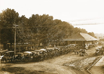
The Waynesville Train Depot in Frog Level sometime in the late 1890s.
Waynesville began to see development after arrival of the railroad in 1884. The agricultural, lumber and tourism industries in Waynesville and Haywood County began to thrive as access to the west was opened up.
The area of Waynesville located along Richland Creek, northwest and down hill from Main Street, was where the railroad tracks were laid. Until this time the area had been essentially a swampland, with a few scattered buildings but no major development. Once the depot was built and the train arrived this section was developed. It was given the name of Frog Level. Frog Level was so named by the local community because of its low-lying location along Richland Creek, the "frog level" when the area flooded.
Downtown and the nearby Frog Level commercial centers of Waynesville continued to be the central focus for social life, transportation, and wholesale and retail businesses through the 1940s. Businesses in the Frog Level area in the 1930s and 1940s included hardware stores, farm supplies, coal sales, auto dealers and garages, furniture stores, wholesale groceries, warehouses and lumber companies, all businesses dependent on the railroad. However, as the automobile became the primary mode of transportation for most residents, the railroad declined in importance. This in turn lead to a shift of business away from Frog Level. The last passenger train arrived in Waynesville in 1949, and freight trains pass through Frog Level twice daily, with most trains continuing on to Sylva.
By the 1980s the railroad in Waynesville had been integrated into the Southern Railway Company system. The first depot burned in 1900, but it was soon replaced with another depot that remained standing until 1987.
Neighborhoods[]

Downtown Waynesville in Summer.


Town of Waynesville Municipal Center
- Downtown - Once the primary retail business center of the town, downtown Waynesville is now home to art galleries, cafes and restaurants, shops, banks, doctors, and the town government/administration buildings.
- Frog Level - The historic district whose name came about because of frequent flooding of Richland Creek. In the 70s and 80s it was known as a seedy part of downtown, mainly due to a now-closed bar called The Tap Room. In recent years, the revitalization of Main Street has spread down into this area. A mural in the area, once a frog sitting on a level, is being replaced by a mural featuring a majority of Folkmoot themes. The historic Murphy Branch of the old Western North Carolina Railroad runs through Frog Level and still carries freight rail traffic from Norfolk Southern Railway which now owns the line.
- Hazelwood - Due to financial troubles, this once independent town ceased to exist and was annexed by Waynesville in 1995.
- Laurel Ridge - The Laurel Ridge neighborhood is connected to a country club of the same name, and features a golf course, pool, tennis courts, and upscale mountain homes.
- West Waynesville - The once industrial part of town. A large shopping center called Waynesville Commons now sits on the site of the old Dayco factory and includes a Wal-Mart Super Center and Best Buy.
- Russ Avenue - The newer business district, which features restaurants, retail stores, auto dealerships, banks, grocery stores, and the like. Russ Avenue is the most traveled surface street in Haywood County.
The "Battle" of Waynesville[]
Waynesville was the scene of the last and perhaps most unusual skirmish in the eastern theater of the American Civil War. On May 6, 1865, Union Colonel William C. Bartlett's 2nd North Carolina (Federal) Mounted Infantry were raiding, pillaging, burning homes and engaging in other activities to undermine the economic base of the area and were attacked at White Sulphur Springs (east of Waynesville) by a detachment of rebels from the Thomas Legion of Highlanders, who had been summoned for help by locals. East of the Mississippi, Thomas' Legion fired "The Last Shot" of the Civil War in White Sulphur Springs, North Carolina. The Legion consisted of soldiers who had served under Jubal A. Early during the Shenandoah Valley Campaigns of 1864, but had been sent back to their native North Carolina mountains to engage in guerrilla warfare against the remaining Union forces. The disoriented Union soldiers retreated into Waynesville, and on the evening of May 6 remaining elements of the Thomas Legion surrounded the town. The soldiers lit numerous bonfires on the ridges above the town and engaged in war chants in an effort to intimidate the Federals. The following day the Confederate commanders Gen. James Green Martin and Col. William Holland Thomas (for whom the Legion was named) negotiated a surrender. These commanders had been made aware that Generals Robert E. Lee and Joseph E. Johnston had already capitulated, and that continued hostilities would prove pointless.
Transportation[]
Waynesville is serviced by two or more freight trains daily via the Norfolk Southern Railway and is connected to Interstate 40 and the rest of Southwestern North Carolina via the Great Smoky Mountains Expressway giving it easy access to Knoxville, Tennessee and Asheville. There is no airport in Haywood County mostly due to its close proximity to the Asheville Regional Airport and Knoxville's McGhee Tyson Airport. Asheville is about a 30 minute drive east, Knoxville is an hour and a half to the west.
Schools[]
- Tuscola High School
- Waynesville Middle School
- Central Elementary School
- Junaluska Elementary
- Hazelwood Elementary
Waynesville Watershed[]
Waynesville’s watershed is located southwest of the town and covers an area of 8,400 acres (34.0 km2) of town-owned land on the headwaters of Allens Creek making it much larger than the town itself (7.9 square miles.) Tributary streams within the watershed flow into the Waynesville Reservoir, a 50-acre (200,000 m2) man-made lake created by a dam on Allens Creek. The reservoir and surrounding watershed are classified by the State of North Carolina as WS-1. This classification is the state’s most stringent and forbids development within the watershed boundary.
Political controversies[]
Waynesville attracted national media attention in 2005 when Chan Chandler, the pastor of East Waynesville Baptist Church, expelled nine church members because they had voted for John Kerry, the Democratic candidate in the 2004 United States presidential election. Forty other members of the church resigned in protest and the pastor was eventually forced to step down under pressure from his congregation and other members of the community.[5]
Film Appearances[]
Cold Mountain, located 15 miles (24 km) southeast of Waynesville within the Pisgah National Forest, was made famous by the novel Cold Mountain by Charles Frazier. A major motion picture based on the novel was produced by Miramax Films in 2003.
The 1996 movie My Fellow Americans was filmed in Western North Carolina. The scene where Jack Lemmon and James Garner are chased from a fast food restaurant parking lot in a car and a giant clown sign crashes through their windshield was filmed at the former Long John Silver's, now a Verizon wireless store, on Russ Avenue in Waynesville.
Actor Gig Young, whose real name is Byron Elsworth Barr is buried in the Green Hill Cemetery.
References[]
- ^ a b "American FactFinder". United States Census Bureau. http://factfinder.census.gov. Retrieved 2008-01-31.
- ^ "US Board on Geographic Names". United States Geological Survey. 2007-10-25. http://geonames.usgs.gov. Retrieved 2008-01-31.
- ^ "Find a County". National Association of Counties. http://www.naco.org/Counties/Pages/FindACounty.aspx. Retrieved 2011-06-07.
- ^ "US Gazetteer files: 2010, 2000, and 1990". United States Census Bureau. 2011-02-12. http://www.census.gov/geo/www/gazetteer/gazette.html. Retrieved 2011-04-23.
- ^ Democrats voted out of church because of their politics, members say, USA Today, May 7, 2005
External links[]
- Official website of the Town of Waynesville, NC
- The Mountaineer Newspaper
- Downtown Waynesville Association
- Waynesville Gallery Association
| ||||||||||||||

| This page uses content from the English language Wikipedia. The original content was at Waynesville, North Carolina. The list of authors can be seen in the page history. As with this Familypedia wiki, the content of Wikipedia is available under the Creative Commons License. |